Antiquariat.de

16 résultats
1758900141AG[Leipzig:, Arkstee und Merkus, 1758]. Kupferstich, Blattmaß: 23,5 x 20 cm. Bildmaß: 19 x 14 cm.
1758900139AG[Leipzig:, Arkstee und Merkus, 1758]. Kupferstich, Blattmaß: 24 x 20 cm. Bildmaß: 20,5 x 17 cm.
171862504Fort Marion Feb. 17 1865. one page. Fine. 12mo. A ms. account of about 70 words unsigned relating an attack on the garrison as they were engaged in improving the ditch; their retreat; and their rally. unknown
178836636London: Printed and Sold by John Nichols. 1788. Folio. Pages 831-839 1 blank. "Numb. 96." at upper left corner at head of title. Disbound light margin spotting else Very Good. <br /> <br /> The Commons addresses requests to assist planters from East Florida who have suffered from its cession to Spain. Several petitions are presented from "Persons who have suffered in their Rights and Properties during the late unhappy Dissentions in America in Consequence of their Loyalty to His Majesty and Attachment to the British Government. Printed and Sold by John Nichols... unknown
178836636London: Printed and Sold by John Nichols. 1788. Folio. Pages 831-839 1 blank. "Numb. 96." at upper left corner at head of title. Disbound light margin spotting else Very Good. <br/><br/> The Commons addresses requests to assist planters from East Florida who have suffered from its cession to Spain. Several petitions are presented from "Persons who have suffered in their Rights and Properties during the late unhappy Dissentions in America in Consequence of their Loyalty to His Majesty and Attachment to the British Government. Printed and Sold by John Nichols... unknown books
178018821genève pellet 1780 -in-4 une carte ancienne gravée sur cuivre (Copper etching) en noir par André, gravée par Arrivet. Format : 31 x 20,5 cm, pour illustrer l'uvre de l'Abbé Guillaume-Thomas Raynal intitulée "l'Histoire philosophique et Politique des Etablissemens et du Commerce des Européens dans les Deux Indes", pli central horizontal normal venant d'un atlas( horizontal centerfold), 1780 Genève Pellet Editeur,
1793PHO-760Paris La Villette 1793. 2 vol. in-8, (4)-336 pp. et (4)-453 pp., relié papier époque avec pièce de titre verte, tranches jaunes , plats frottés , illustré de 3 planches dont 2 dépliantes .
179322643(Wien, Schrämbl, 1793). XXXIX S., 4 Bll., 404 S.; 5 Bll., 427 S. 7 (statt 8) gefalt. Kupfertafeln. Kl.-8°. HLdr. der Zeit mit Rückenschild (etw. berieben und bestoßen). [5 Warenabbildungen]
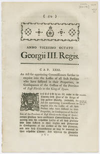
1788WRCAM54472London 1788. 579-584pp. Dbd. Folio. Pinholes at gutter margin. Light tanning. Very good. Very scarce official printing of this Parliamentary act relating to the settlement of compensation for those whose property was lost by the return of Florida to the Spanish in the Treaty of Paris. ESTC locates three copies and OCLC locates a fourth. ESTC N58773. unknown books
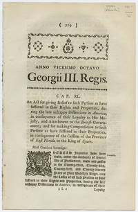
1788WRCAM54471London 1788. 779-787pp. Dbd. Folio. Stab holes at gutter margin. Light tanning. Very good. Very scarce official printing of this act of Parliament that made provisions for those who lost their property when Great Britain ceded Florida back to Spain as a part of the Treaty of Paris in 1783. ESTC locates five copies. unknown books
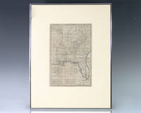
1797139014Paris: Rigobert Bonne 1797. Rare 18th century map of North America by Royal Hydrographer Rigobert Bonne. One page the engraved map extends from Illinois to Florida with one of the earliest insets of Kansas City. Born in the Lorraine region of France French cartographer Rigobert Bonne 1727-1794 was a skilled cartographer and hydrographer and succeeded Jacques Nicolas Bellin as Royal Hydrographer at the Depot de la Marine in 1773. He published many charts for the Depot including some of those for the Atlas Maritimeof 1762. In near fine condition. Matted and framed. The entire piece measures 17 inches by 16 inches. La Louisiane named after Louis XIV of France became a colony of the Kingdom of France in 1682 before passing to Spain in 1763. Louisiana was formed in part of the became part of the Louisiana Purchase from France in 1803. The U.S. would divide that area into two territories the Territory of Orleans which formed what would become the boundaries of Louisiana and the District of Louisiana. Louisiana was admitted as the 18th state of the United States on April 30 1812. Appointed hydrographer of the French Navy at the age of eighteen Jacques-Nicolas Bellin was appointed Hydrographer to the King in 1741. He published numerous sea atlases and charts which would be reprinted into the nineteenth century as well as many maps depicting French colonial territories in the New World. His craftsmanship and commitment to accuracy earned him a distinguished reputation as one of the world's leading cartographers and many other European mapmakers turned to him for source material. Rigobert Bonne unknown
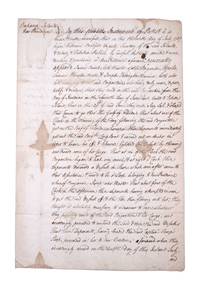
1767351783New Providence Bahamas 1767. 2pp folded folio sheet with integral blank. Old folds minor staining. 2pp folded folio sheet with integral blank. The Brigatine Apollo left the bay of Honduras on 11 June 1767 bound for Rhode Island on a course through the Gulf of Florida. "That about one of the clock in the morning of the day following the said Brigantine got on the reef of Florida whereupon the deponents immediately got out the said Brig.t's long boat and carried out an anchor in order to heave her off & likewise lightened the vessell by throwing over board some of her cargo: That at six of the clock the said brigatine began to leak very much & at eight o'clock these deponents discovered a vessell in shore which soon after came to their assistance & prov'd to be a sloop belonging to New Providence . having attempted in vain to get the said vessell off & the tide then flowing into her they thought it absolutely necessary to endeavor to save whatever they possibly could of the said Brigatine & her cargo and accordingly proceeded to unbend the sails & strip the said vessell . and do hereby solemnly protest aginst the said reef of Florida for all losses damages & expences hitherto sustained thereby ." <br /> <br /> The document does not specify the nature of the cargo going from British Honduras to Rhode Island but was perhaps mahogany or other timber used in colonial New England for cabinet making. unknown
1731189044-1Leiden, P. van der Aa 1731. Kl.8°. (1 w. Bl.), 13 nn. Bll., 290 S.; S. (291) -582, (1 w. Bl.) Mit 2 (wdh.) gest. Titelvign., 9 gef. Kupfern von Soto u. 1 gef. Karte von Florida. Marmor. Lederband der Zeit mit reicher Rückenverg., rotem Rückenschild u. Marmorpapier-Vorsätzen.
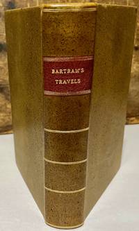
179330176Dublin: For J. Moore W. Jones R. McAllister and J. Rice 1793. Later printing. Leather bound. Very good. Octavo. xxiv 520 pages 11 page index directions to the binder. Frontispiece engraving of Mico Chlucco. Illustrated with 7 plates one folding and one folding map. Later speckled calf leather binding with red leather title label on spine. Newer front and rear end sheets added. Newer head bands top and bottom of text block. Light foxing to frontispiece engraving and title page. Light scattered occasional foxing to the contents. This edition follows the Philadelphia 1791 first edition and the first English edition of 1792. Bartram's classic account of southern natural history native Americans and exploration in the southeastern states during the American Revolution period. <br /> <br /> Howes B 223; Field 94; Sabin 3870; Clark I 197; De Renne Vol. 1 p.257; See Field 96. For J. Moore, W. Jones, R. McAllister, and J. Rice unknown
17237416AMadrid, Oficina Real für N. R. Franco, 1723. 4°. 16 Bll., 268 S., 6 Bll. Flexibler Pergamentband der Zeit mit 2 Schließschlaufen. Vord. Innengelenk aufgeplatzt. 1 Bl. mit Einriß. [2 Warenabbildungen] 2. Auflage.
17236495AMadrid, Franco, 1723. 4°. XXX, II, 268 S., XII S. Pergamentband der Zeit.