[Photograph] [Pensacola, Florida]Biblio.com
1 698 résultats
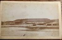
35275Pensacola Florida: Perry Photographer n.d. Photograph. Fair. Photograph. Approximately 8.5" x 5" albumen print on thick card. Photographer imprint on the back: "Perry Photographer Portraits Views Pastels Crayons. Pensacola Florida." Foxing and light brown staining to the photograph. Small mark bottom edge of the image. Light edge wear to the card. "Ft Barancas" written in hand on the back. No information found on the photographer. <br /> <br /> Fort Barrancas located in Pensacola Florida is a historic fort that has been part of the Gulf Islands National Seashore since 1980. It sits on a bluff overlooking Pensacola Bay and was built to protect the United States from foreign invaders. The fort is one of three historic structures in the area along with the Spanish Water Battery and Advanced Redoubt. <br /> The fort was completed in 1844 and is made of 6 million bricks with walls 4 feet thick and 20 feet high. It was used by Spain France Britain and the United States. During the Civil War Confederate soldiers occupied the fort after Union troops moved to Fort Pickens. Fort Barrancas and Fort Pickens exchanged heavy cannon fire during the war. AI Overview. Perry Photographer unknown
0265980437.Ghardcover. Good. Access codes and supplements are not guaranteed with used items. May be an ex-library book. hardcover
1391394534.Ghardcover. Good. Access codes and supplements are not guaranteed with used items. May be an ex-library book. hardcover
026016531X.Ghardcover. Good. Access codes and supplements are not guaranteed with used items. May be an ex-library book. hardcover
1527930424.Gpaperback. Good. Access codes and supplements are not guaranteed with used items. May be an ex-library book. paperback
0260966584.Ghardcover. Good. Access codes and supplements are not guaranteed with used items. May be an ex-library book. hardcover
0266644457.Gpaperback. Good. Access codes and supplements are not guaranteed with used items. May be an ex-library book. paperback
0331254484.Ghardcover. Good. Access codes and supplements are not guaranteed with used items. May be an ex-library book. hardcover
1972ZB394051Florida State University 1972-1999. volumes 6-7; 14; 20-22; 24-29; 32-33. 1972-1999 complete volumes partly bound library markings textually clean & tight price is for the lot. - If you are reading this this item is actually physically in our stock and ready for shipment once ordered. We are not bookjackers. Buyer is responsible for any additional duties taxes or fees required by recipient's country. Photos available upon request. Florida State University unknown
1164650556.Gpaperback. Good. Access codes and supplements are not guaranteed with used items. May be an ex-library book. paperback
0469680784.Ghardcover. Good. Access codes and supplements are not guaranteed with used items. May be an ex-library book. hardcover
143685167X.Gpaperback. Good. Access codes and supplements are not guaranteed with used items. May be an ex-library book. paperback
1911392022Indianapolis: The Bobbs-Merrill Company 1911. Hardcover. Very Good. First edition. Decorative green cloth stamped in yellow. Illustrated by George Kerr. Wear on the board edges bumped corners and rubbing else very good. "The story of how we look from where the dog sits. The Bobbs-Merrill Company hardcover
191318703NY: The New York Book Co. Good with no dustjacket. 1913. Hardcover. Pages are very good and clean. Covers have some moderate to average wear but the book is very sound. Spine is lightly faded. ; Small 8vo 7½" - 8" ; 182 pages . The New York Book Co. hardcover
191141195Indianapolis: Bobbs Merrill 1911. First Edition . Cloth Hard Cover. Fine/No Dust Jacket. Kerr George. Hint of rubbing to corners. 182pp. Color plates including tissue-covered frontispiece by George Kerr. Decorated green cloth printed in light green. Very scarce novel told from the point of view of a dog. Size: 16mo - over 5¾" - 6¾" tall <br/> <br/> Bobbs Merrill hardcover
0331062976.Gpaperback. Good. Access codes and supplements are not guaranteed with used items. May be an ex-library book. paperback
0331306360.Ghardcover. Good. Access codes and supplements are not guaranteed with used items. May be an ex-library book. hardcover
1334779147.Gpaperback. Good. Access codes and supplements are not guaranteed with used items. May be an ex-library book. paperback
0484044575.Ghardcover. Good. Access codes and supplements are not guaranteed with used items. May be an ex-library book. hardcover
1334778965.Gpaperback. Good. Access codes and supplements are not guaranteed with used items. May be an ex-library book. paperback
0656461330.Ghardcover. Good. Access codes and supplements are not guaranteed with used items. May be an ex-library book. hardcover
192140730Washington D.C.: Published by the United States Coast and Geodetic Survey 1921. Large folding nautical chart printed on heavy paper stock. Colored with minor wear. A rare original coastal survey of the south east Florida coastline from Biscayne Bay south of Miami to the northern tip of Islamorada including Key Largo Tavernier and Everglades National Park.<br/> <br/> Established by President Thomas Jefferson in 1807 as the Survey of the Coast the U.S. Coast and Geodetic Survey was the United States' first civilian scientific agency. This agency has followed its mission to survey the U.S. coastline create nautical charts of the coast and help increase maritime safety since its founding and has often played fascinating roles in significant chapters of U.S. history. It served in all theaters of the Civil War in the service of the Union Army and Navy pioneered acoustic exploration in the wake of the sinking of the Titanic and during WWI it worked to detect enemy submarines. In addition this agency worked to survey and produce detailed maps and renderings of the U.S. coast. These nautical survey maps commonly referred to as "T-sheets" provide fascinating insights into the history of the United States coastline which has and will continue to shift. These maps are the most important data source for understanding the physical and ecological characteristics of the U.S. shoreline. The present map of the Florida coastline shows part of the Overseas Railroad prior to its partial destruction and abandonment after a Hurricane in 1935. This map is a highly detailed and accurate sea chart of the Keys region and an important historical view of a developing Florida. Published by the United States Coast and Geodetic Survey unknown
191740708Washington D.C.: Published by the United States Coast and Geodetic Survey 1917. Large folding nautical chart printed on heavy paper stock. Colored with minor wear. A rare coastal survey of Florida from Port Canaveral to Vero Beach including Satellite Beach Melbourne and Palm Bay.<br/> <br/> Established by President Thomas Jefferson in 1807 as the Survey of the Coast the U.S. Coast and Geodetic Survey was the United States' first civilian scientific agency. This agency has followed its mission to survey the U.S. coastline create nautical charts of the coast and help increase maritime safety since its founding and has often played fascinating roles in significant chapters of U.S. history. It served in all theaters of the Civil War in the service of the Union Army and Navy pioneered acoustic exploration in the wake of the sinking of the Titanic and during WWI it worked to detect enemy submarines. In addition this agency worked to survey and produce detailed maps and renderings of the U.S. coast. These nautical survey maps commonly referred to as "T-sheets" provide fascinating insights into the history of the United States coastline which has and will continue to shift. These maps are the most important data source for understanding the physical and ecological characteristics of the U.S. shoreline. The present map is a highly detailed and accurate sea chart of the Florida coast and an important historical view of the developing state. Published by the United States Coast and Geodetic Survey unknown
191740734Washington D.C.: Published by the United States Coast and Geodetic Survey 1917. Large folding nautical chart printed on heavy paper stock. Colored. A rare original coastal survey of Florida from Vero Beach to Jupiter including Fort Pierce Port St. Lucie Stuart and the Hobe Sound with an inset map of the Narrows in the upper left corner.<br/> <br/> Established by President Thomas Jefferson in 1807 as the Survey of the Coast the U.S. Coast and Geodetic Survey was the United States' first civilian scientific agency. This agency has followed its mission to survey the U.S. coastline create nautical charts of the coast and help increase maritime safety since its founding and has often played fascinating roles in significant chapters of U.S. history. It served in all theaters of the Civil War in the service of the Union Army and Navy pioneered acoustic exploration in the wake of the sinking of the Titanic and during WWI it worked to detect enemy submarines. In addition this agency worked to survey and produce detailed maps and renderings of the U.S. coast. These nautical survey maps commonly referred to as "T-sheets" provide fascinating insights into the history of the United States coastline which has and will continue to shift. These maps are the most important data source for understanding the physical and ecological characteristics of the U.S. shoreline. The present map of the Florida coastline was issued before the incorporation of Jupiter Township in 1925 and predates the development of Route 1. A railroad is marked as following the approximate route of the highway. This map is a highly detailed and accurate sea chart of the Jupiter region and an important historical view of a developing Florida. Published by the United States Coast and Geodetic Survey unknown
1998Q-0966590708Inn Route 1998-11-01. Hardcover. New. In shrink wrap. Looks like an interesting title! Inn Route hardcover