Centenary College of LouisianaBiblio.com

1 088 résultats
0365569488.Ghardcover. Good. Access codes and supplements are not guaranteed with used items. May be an ex-library book. hardcover
0366357247.Ghardcover. Good. Access codes and supplements are not guaranteed with used items. May be an ex-library book. hardcover
1396591877.Ghardcover. Good. Access codes and supplements are not guaranteed with used items. May be an ex-library book. hardcover
1391506936.Gpaperback. Good. Access codes and supplements are not guaranteed with used items. May be an ex-library book. paperback
0331112507.Ghardcover. Good. Access codes and supplements are not guaranteed with used items. May be an ex-library book. hardcover
ria9781138123014_inpPaperback / softback. New. New Book; Fast Shipping from UK; Not signed; Not First Edition; The Woodwinds: Perform Understand Teach provides comprehensive coverage about the woodwind family of musical instruments for prospective instrumental music teachers. What sets this book apart is its focus on how to teach the instrumen paperback
0260004103.Ghardcover. Good. Access codes and supplements are not guaranteed with used items. May be an ex-library book. hardcover
0266003370.Gpaperback. Good. Access codes and supplements are not guaranteed with used items. May be an ex-library book. paperback
0260690694.Ghardcover. Good. Access codes and supplements are not guaranteed with used items. May be an ex-library book. hardcover
1998016314Hollywood California U.S.A.: Seven Arts Pr 1998. Book. Fine. Oblong Paperback. First Edition. A Fine copy of this oversized exhibition catalog. Seven Arts Pr Paperback
ria9780367579616_inpPaperback / softback. New. New Book; Fast Shipping from UK; Not signed; Not First Edition; Learn the basics of white noise theory with White Noise Distribution Theory. This book covers the mathematical foundation and key applications of white noise theory without requiring advanced knowledge in this area. paperback
192041176Washington D.C.: Published by the United States Coast and Geodetic Survey 1920. Large folding nautical chart printed on heavy paper stock. Colored. A rare original coastal survey of southern Louisiana coast and includes Pecan Island Lower Mud Lake the Rockefeller Wildlife Refuge and the Mementau River.<br/> <br/> Established by President Thomas Jefferson in 1807 as the Survey of the Coast the U.S. Coast and Geodetic Survey was the United States' first civilian scientific agency. This agency has followed its mission to survey the U.S. coastline create nautical charts of the coast and help increase maritime safety since its founding and has often played fascinating roles in significant chapters of U.S. history. It served in all theaters of the Civil War in the service of the Union Army and Navy pioneered acoustic exploration in the wake of the sinking of the Titanic and during WWI it worked to detect enemy submarines. In addition this agency worked to survey and produce detailed maps and renderings of the U.S. coast. These nautical survey maps commonly referred to as "T-sheets" provide fascinating insights into the history of the United States coastline which has and will continue to shift. These maps are the most important data source for understanding the physical and ecological characteristics of the U.S. shoreline. The present map is a highly detailed and accurate sea chart of the southern Louisiana coast from Pecan Island to the Mementau River and an important historical view of the developing Louisiana. Published by the United States Coast and Geodetic Survey unknown
0886981557New. Brand new and still unused unknown
0886981557.Gpaperback. Good. Access codes and supplements are not guaranteed with used items. May be an ex-library book. paperback
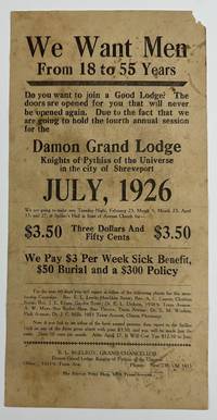
19265509Shreveport: The Service Print Shop July 1926. Good. Broadside 12 x 6 inches. Old folds small chip to upper corner noticeable soiling and staining. An unrecorded broadside advertising a membership drive for the Damon Grand Lodge of the Knights of Pythias of the Universe in Shreveport Louisiana in the midst of the Roaring Twenties. The text asks "Do you want to join a Good Lodge" before asserting that this present membership drive is a unique opportunity: "The doors are opened for you that will never be opened again." The text then relays the price for membership $3.50 and then fifty cents per month and details some of the potential benefits of joining the Knights: "We Pay $3 Per Week Sick Benefit $50 Burial and a $300 Policy." The broadside is signed in type at the bottom by B.L. McElroy Grand Chancellor of the Damon Grand Lodge. Interestingly the Damon Lodge was located 10511/2 Texas Avenue in Shreveport; the present broadside was printed by the Service Print Shop on the same street at 1009 Texas Avenue. As such the print shop was most likely a Black-owned-and-operated enterprise. Another interesting note -- near the bottom several individuals are named as contacts for prospective new members mainly pastors and doctors; most of these men also reside or work on Texas Avenue. A decidedly ephemeral and hyper-local advertisement for a Shreveport lodge of the Knights of Pythias with no copies in OCLC or anywhere we could think to check. The Service Print Shop, July unknown
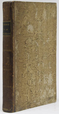
1802264638Paris: Dentu 1802. First edition. With folding engraved map by L. Collin at front with a fanciful depiction of the American west. viii 382 pp. 1 vols. 8vo. Quarter contemporary calf and boards speckled edges. Handsome copy. Blue bookseller ticket of Ch. Chadenat Librairie Américaine et Coloniale Paris. Very good plus. First edition. With folding engraved map by L. Collin at front with a fanciful depiction of the American west. viii 382 pp. 1 vols. 8vo. Howes B-243; Clark II 76; Dionne II 915; Field 99; Sabin 3979; Streeter III 1571; Wagner-Camp 1a Dentu unknown
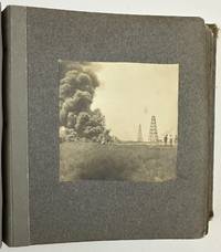
19033176Various locations in Louisiana 1903. About very good. Twelve leaves illustrated with twenty silver gelatin photographs. Contemporary gray cloth photograph album string-tied front cover stamped in gilt "The Kodak Book." Noticeable soiling and rubbing to boards edges worn. Two photographs detached mild wear to a few pictures but overall nice condition. A charming collection of vernacular images of southern Louisiana in the first few years of the 20th century taken by local resident May Hill Wilkinson. Wilkinson has signed the inside front cover in pencil "Mrs. C A Wilkinson May Hill Lake Charles and Jennings." Additionally manuscript notes on the inside front cover a couple of slips inside the album and on the verso of one of the loose photographs also indicate Wilkinson's authorship of the pictures per her daughter Lyllis who indicates the pictures were taken before she was born in Jennings in 1904. Wilkinson's photographs mostly depict scenes on the waters of Lake Charles and Lake Arthur but also include a handful of scenes in the wooded areas around Jennings.<br /> <br /> A particularly striking photograph captures an oil field fire in Evangeline Louisiana according to a later note from Lyllis opposite the photo; Evangeline is only six miles from Jennings and was the site of the first oil strike in Louisiana in September 1901. Wilkinson's photograph captures a billowing cloud of smoke at left with men and oil derricks visible to the right. This is likely one of the earliest vernacular photographs of the Evangeline Oil Field which would bring untold riches to the people of Jennings. A nice mixture of images from a time and place rarely seen in vernacular photographs. unknown
192041170Washington D.C.: Published by the United States Coast and Geodetic Survey 1920. Large folding nautical chart printed on heavy paper stock. Colored. A rare original coastal survey of the southern Louisiana coast and includes Pecan Island Vermilion Bay and Marsh Island.<br/> <br/> Established by President Thomas Jefferson in 1807 as the Survey of the Coast the U.S. Coast and Geodetic Survey was the United States' first civilian scientific agency. This agency has followed its mission to survey the U.S. coastline create nautical charts of the coast and help increase maritime safety since its founding and has often played fascinating roles in significant chapters of U.S. history. It served in all theaters of the Civil War in the service of the Union Army and Navy pioneered acoustic exploration in the wake of the sinking of the Titanic and during WWI it worked to detect enemy submarines. In addition this agency worked to survey and produce detailed maps and renderings of the U.S. coast. These nautical survey maps commonly referred to as "T-sheets" provide fascinating insights into the history of the United States coastline which has and will continue to shift. These maps are the most important data source for understanding the physical and ecological characteristics of the U.S. shoreline. The present map of the Louisiana coastline is notable for the inclusion of Marsh Island which was deeded to the state in 1920 the year this map was produced. It is a highly detailed and accurate sea chart of the Vermilion Bay and an important historical view of the developing Louisiana. Published by the United States Coast and Geodetic Survey unknown
192141179Washington D.C.: Published by the United States Coast and Geodetic Survey 1921. Large folding nautical chart printed on heavy paper stock. Uncolored. A rare original coastal survey of Vermillion Parish including Vermilion Bay Marsh Island Pecan Island White Lake Cote Blanche Bay and Trinity Shoal.<br/> <br/> Established by President Thomas Jefferson in 1807 as the Survey of the Coast the U.S. Coast and Geodetic Survey was the United States' first civilian scientific agency. This agency has followed its mission to survey the U.S. coastline create nautical charts of the coast and help increase maritime safety since its founding and has often played fascinating roles in significant chapters of U.S. history. It served in all theaters of the Civil War in the service of the Union Army and Navy pioneered acoustic exploration in the wake of the sinking of the Titanic and during WWI it worked to detect enemy submarines. In addition this agency worked to survey and produce detailed maps and renderings of the U.S. coast. These nautical survey maps commonly referred to as "T-sheets" provide fascinating insights into the history of the United States coastline which has and will continue to shift. These maps are the most important data source for understanding the physical and ecological characteristics of the U.S. shoreline. The present map of the Louisiana coastline is notable for the inclusion of Marsh Island which was deeded to the state in 1920 the year this map was produced. It is a highly detailed and accurate sea chart of the Vermilion Parish and an important historical view of the developing Louisiana. Published by the United States Coast and Geodetic Survey unknown
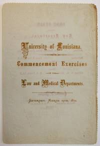
187036136New Orleans 1870. Folded decorative leaf stamped in blind. 3 1 blank pp. Title printed in gilt lettering text in beige lettering. Very Good.<br /> <br /> The University of Louisiana is the predecessor of Tulane University in New Orleans. The commencement program of each department is printed noting the salutatorian and valedictorian and committees of each department. <br /> See OCLC 320842972 1- LSU. unknown
0260021555.Ghardcover. Good. Access codes and supplements are not guaranteed with used items. May be an ex-library book. hardcover
1528050487.Gpaperback. Good. Access codes and supplements are not guaranteed with used items. May be an ex-library book. paperback
0666592314.Ghardcover. Good. Access codes and supplements are not guaranteed with used items. May be an ex-library book. hardcover
1949ZB447296Baton Rouge: ca. 1949. oblong quarto 32 pp. illustrated throughout; minor library markings later plain paper wrappers over original printed paper wrappers good. - If you are reading this this item is actually physically in our stock and ready for shipment once ordered. We are not bookjackers. Buyer is responsible for any additional duties taxes or fees required by recipient's country. Baton Rouge: unknown
1528309561.Gpaperback. Good. Access codes and supplements are not guaranteed with used items. May be an ex-library book. paperback