Mekong Interim CommitteeBiblio.com
11 résultats
X2079<p>Project Documentation: Summary of Trends in the Economy of Thailand Aug.1979 Geomorphology of the Mekong Delta Dec. 1982</p><p>15.5.89 5.2.80 2.2.81 15.2.82 24.9.82 1.6.84</p><p>PRINT Bangkok 1979-84 WL CODE X2079 SIZE 3-24 pp. 210 x 300 mm shtees BOOK WEIGHT 0.200 Kg PACKING WEIGHT 0.200 Kg</p> paperback
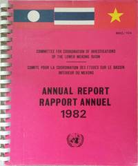
X1246*<p>Annual Report Rapport Annuel 1982: Committee for Coopdination of Investigations of the Lower Mekong Basin MKG/104 PRINT Bangkok 1982 EnglishFrench text WL CODE X1246 SIZE 144 pp. 20 pp. illus. in col. 225 x 280 mm BOOK WEIGHT 0.600 Kg PACKING WEIGHT 0.200 Kg</p> paperback
6206171051.Gpaperback. Good. Access codes and supplements are not guaranteed with used items. May be an ex-library book. paperback
6202533986.Gpaperback. Good. Access codes and supplements are not guaranteed with used items. May be an ex-library book. paperback
6203560154.Gpaperback. Good. Access codes and supplements are not guaranteed with used items. May be an ex-library book. paperback
6203560200.Gpaperback. Good. Access codes and supplements are not guaranteed with used items. May be an ex-library book. paperback
620255133X.Gpaperback. Good. Access codes and supplements are not guaranteed with used items. May be an ex-library book. paperback
6203560197.Gpaperback. Good. Access codes and supplements are not guaranteed with used items. May be an ex-library book. paperback
6203560146.Gpaperback. Good. Access codes and supplements are not guaranteed with used items. May be an ex-library book. paperback
6203560170.Gpaperback. Good. Access codes and supplements are not guaranteed with used items. May be an ex-library book. paperback
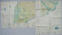
1967203840Washington D.C.: Army Map Service. 1967. Two printed colour adjoining maps 73 x 55.6 cms and 55.6 x 73 cms original folds inked operational annotations to the Quan Long sheet multiple marginal legends noting aerodromes and radio facilities roads railroads and boundaries glossary of terms much of the text is in both English and Vietnamese in very good condition. Detailed U. S. Army maps of the Mekong Delta and Southern Vietnam extending from Rach Gia in the north to the area just south of Quan Long Ca Mau in the south and east including BacLieu and CanTho. The island of Con son is at lower right of the Khanh Hu'ng sheet. Operational notes are inked around Quan Long are marked and the U Minh Forest the impenetrable "forest of darkness" is noted in ink. <br> <br>. . Army Map Service. unknown