(BLANCHARD, Théophile & BARRIERE Frères):Livre Rare Book
1 643 résultats
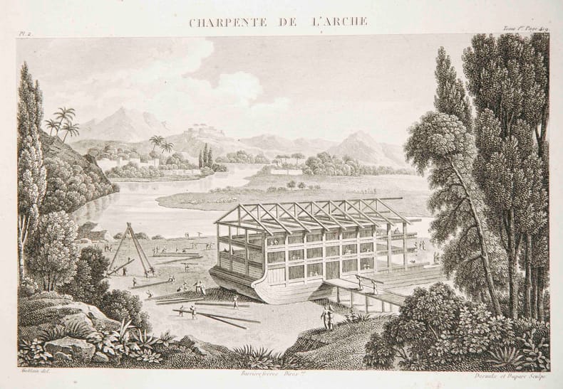
34523aafParis, Barrière frères, s.d. (ca. 1825), in-4to oblong, sans p. de titre + 37 planches gravées, (la gravure: 21x30 cm.) / ( la feuille 29x42 cm.), reliure en demi-cuir, fragile, pet. fente en bas de la charn. supér., plats recouverts de papier marbré, qqs lég. frottements et pet. taches.
Carta di cm. 28x20,5, più i margini. Segni di piegatura senza alcun danno ne macchie.
183 p., 495 fig. n/b et coul. En français et néerlandais. Catalogue d'exposition, Bruxelles, Banque Bruxelles-Lamrt, 3 février-26 mars 199. Inv. Th 62
339 p., nombreuses fig. et tableaux, 23 planches photographiques hors-texte. Travaux du Cercle d'Etudes Numismatiques, volume 10. Inv. 18156.
160 p., nbr. ill. n/b et coul. (Découvertes Gallimard. Archéologie 276). Inv. 11370
357 p., 493 fig. n/b, 24 pl. coul. Catalogue d'exposition. Prähistorische Staatsammlung München, 20 Januar-18 April 1982. Inv. 11306
406 p., 8 pl. Cassé en 2. Inv. 15335
197 + LXX planches hors-texte, fig. dans le texte. Inv. 11024.
65p., 43 pl. (Supplementi 4 alla Rivista di Archeologia). Inv. 15522
349 p., 385 fig. coul. Inv. h 5
385 p., 24 gravures, 1 carte dépl. Demi percaline verte, petites arraches aux coins. Rousseurs. Inv. 17438
42786Musée du Petit Palais.26 Octobre 1983-8 Janvier 1984.In-4,couv.souple ill.en couleurs.320 p.Très nombreuses photos en noir et en couleurs. TBE.
193954541939 Imprimerie de l'Est Chaumont 1939 In8 broché 128 pages
Fine Turkish Paperback. Roy. 8vo. (24 x 17 cm). In Turkish. [viii], 135, [9] p. 1860-1861 Suriye buhrani: Osmanli diplomasisinden bir örnek olay.
Very Good Turkish Paperback. 4to. (27 x 20 m). In Turkish. 44 p., 14 military plans in the end-pocket (no missing). Some foxing on covers and pages, chipped on spine. Otherwise a good copy. 1918 senesinde Türk ordusunun Filistin ve Suriyeden çekilisinde 3. Sv. tümeninin hareketleri. 3 copies in OCLC: 70248831. First and Only Edition.
Fine Turkish Paperback. Cr. 8vo. (20 x 14 cm). In Turkish. 296, [18] p., b/w plates. 1946 Mehabad Kürt Cumhuriyeti. Translated by M. Emin Bozarslan.
14445Four STEREOVIEWS of SYRIA DAMASCUS BEIRUT circa 1900-1910 Published by Keystone view Company. These 4 stereo cards are of good qualities and show a Syrian in Arab outfit near his horse 2 of theother photos show city views cica 1900. Very good condition. unknown books
Very Good English Original color map folded in its papers. Very good. Folded. Atlas folio. (60 x 47 cm). In English. [MAP of FRENCH MANDATE SYRIA and LEBANON] Map of Syria and Lebanon. Scale: 1:1.100.000. No date.
Very Good French Scarce color lithographed tourist map of Syria and Lebanon, showing international boundaries, transportation, archaeological, historical, and military ruins, water features, distances between places and populated places. Relief is shown by hachures, bathymetric tints, and spot heights. Includes 28 attractive drawings in red of tourist sites in Syria and Lebanon: Damas, Palmyre, Afqa, Hama, Homs, Meyrouba, Saida, Beit ed-Dins, Djebail, Led Cedres, Krak des Chevaliers, Massiaf, Antioche, Deir Smane, El Goilla, Aleppo, etc. "Relief is shown by contours and spot heights. Includes 28 drawings of tourist sites in Syria and Lebanon, listing the city. "7 -49". On lower right margin.'". Free French Forces was the government-in-exile led by Charles de Gaulle during the Second World War, and its military forces, that continued to fight against the Axis powers as an Allied nation, following the Fall of France. Set up in London in June 1940, it organized and supported the Resistance in Occupied France, and established a foothold within several French colonies in Africa. Original color lithograph map of Syria and Lebanon. 57x72 cm., on sheet 63x84 cm. In French. Scale: 1:1.000.000. Edition of May 1942.
Very Good Arabic Original chromo-lithograph map in brown tones. On a special paper with an ongoing blindstamped "Regestre Robur" during the borders. Folded. 70x100 cm. In Arabic. Scale: 1 /1.000.000. Chipped on margins, split on folded traces. Slight discoloration and one stain on lower margin. Otherwise a good copy. An attractive and detailed map of Syria shows the capital (as Aleppo n that map), other cities like Damascus, Raqqa, Homs, Latakia, Ayn al-Arab, Idlib, Hama, Deir Ez-Zor, Jarabulus, et alli. And it shows Turkey on the north (as Turkey containing Hatay and Alexandrette), The Mediterranean shores of the land as well as Lebanon and Palestine (and Jerusalem) on the west, Sharq al-Urdun (Jordan) and Iraq on the south and east. It's very detailed on showing the roads spread throughout the land like railways and ancient roads from the Roman period. Additionally this roads can be followed to the other Arabic countries and regions on the map. This map was calligraphed by Kamel Al-Baba, (1905-1991), who was a Lebanese contemporary / modern calligrapher. He is the son of famous calligrapher Mokhtar Al-Baba. Cannot be found in WorldCat.; Not in Library of Congress Map Collection. Very scarce.
Very Good French Eight panels of panoramic photograph folded into original printed light brown card wrappers titled "Souvenir d'Alep (Syrie). / Panoramique d'Alep" and "Editeur Wattar Freres, Alep (Syrie)" on the cover. Open size: 9x112 cm. In French. Contemporarily repaired verso of hinges by tape, overall a fine copy. Scarce wide-angle black and white photo-lithographic panoramic view of one of the oldest and most important cities of the Islamic Middle East, Aleppo of Syria, taken at twilight time, in the 1920s, when the country was under the French Occupation between 1920-22. This attractive photograph was edited and also probably taken by the Wattar Brothers, who were the famous and prolific editors and photographers of Syria and Southeast Anatolia including Kilis, Aintab (today: Gaziantep), etc. The Wattar Freres' descendants were present in Syria until the early 2000s (Serifoglu). This panorama is uncommon, showing many architectural buildings peculiar to Aleppo are no longer in place after the wars, especially the ongoing Syrian Civil War.
Very Good Arabic Paperback. Small 4to. (26 x 18 cm). Text is entirely in Arabic with bilingual title in English and Arabic on cover. 16 p. [Off-print] Research report on urbanism in Islam (Monograph Series No. 3):1) The social forces in the Arab-Syrian cities in the 19th century: The latest period of the Ottoman rule. 2) Stages in formation and development of the social forces in the Syrian cities in the present period. [COMPLETELY ARABIC]. Abdullah Hanna was born in the Syrian village of Deir Attiyah in 1932, and earned a PhD in history from the University of Leipzig in 1965. Blocked from Syrian academia due to his political leanings, Hanna instead became an instructor in Syrian secondary schools. He became a specialist on agrarian history and labour movements in Syria. His works, published in Arabic, include books on intellectual trends in Syria and Lebanon; the Syrian and Lebanese labour movements; anti-fascism in Syria and Lebanon; the agrarian question in Syria and Lebanon; and obstacles to the transition to capitalism. (Arab Center for Research & Policy Studies). Delivered at the Seminar Research Group D: Cities andstructures of power, October 15, 1988. Institute of Oriental and Occidental Studies, Kansai University.
1373614Paris: La revue française de l'élite européenne, 1950 in-4, 116 pages., illustrations. Broché. Numéro consacré au Moyen Orient (Irak, Syrie, Arabie Saoudite, Liban).
1373570Paris: Musée de l'Homme, Museum National d'Histoire Naturelle, 1989 in-4, nombreuses illustrations. Broché, très bon état. Sommaire: Joseph CHELHOD, Un mariage dans le désert de Syrie en 1821. - Elisabeth BOPEARACHCHI, Quelques aspects du culte des nâga dans la littérature cinghalaise ancienne et populaire. - Lajos BOGLAR, L'art des forêts ou la forêt des arts chez les Indiens Piaroa, Venezuela. - Roger SABAN et Marie-Pierre DUPIN, Objets en corne et peau de rhinocéros. - Joaquim GALARZA, Autour du Codex Santa Anita. - Christine HEMMET, La Thaïlande, le pays au million d'amulettes. - Marinella CAROSSO, "Coudre en lin" et "coudre en soie", interprétation des broderies d'un vêtement traditionnel sarde. - Solange THIERRY, Yvette Laplaze (1924-1988).
Original single-sheet steel engraving of a very fine quality. Overall size ca. 215 x 270 mm. Image size ca. 130 x 190 mm. A two-line caption engraved at bottom in elegant handtooled open-face and italic types. Engraved Artist's and Engraver's signatures underneath image. Engraved Publisher's line below. The print is in its original state, trimmed and gilded on three sides. It is printed with warmer ink, somewhat more dramatic in mood, with fine, crisp detail, subtlety and elegance. In overall fine condition. (Some marginal spotting.) Preserved in pH-balanced, acid-free Renaissance archival paper. ~ A delicately executed steel engraving, representing a major illustrative work on 19th century Palestine, Syria, and Asia Minor. William Henry Bartlett (born London, 1809) was one of the foremost illustrators of topography of his generation. He travelled extensively throughout Britain, the Americas, and the Middle East, producing his work on location. In 1854 he made his last trip to the Holy Land; he died of fever on board a French ship on his return voyage to England. Bartlett's primary concern was to extract the picturesque aspects of a place and render "lively impressions of actual sights", as he wrote in the preface to "The Nile Boat" (London, 1849). His work became widely known through the numerous engravings after the original drawings and paintings he made. The interest in these engravings today is as much for the exquisite quality of the rendering and presentation of the architecture of the period, as it is for the representation of the landscape. Published in 1836 by Peter Jackson, Late Fisher, Son & Co. of London, it was originally accompanied by descriptions written by John Carne.