Electronic Navigation Research InstituteBiblio.com

341 résultats
43205438-nnew. unknown
19492082402113503178Not Available 1949. Soft Cover. Fine. Number of books: 14 Not Available paperback
2021SONG981334668XSpringer 2021-03-24. 1st ed. 2021. hardcover. Used: Good. 6.14x0.81x9.21. Buy with confidence. Excellent Customer Service & Return policy. Springer hardcover
2019x-9811370850Springer 2019. Hardcover. New. 300 pages. 9.25x6.10x0.87 inches. Springer hardcover
3975Portland Oregon:: The Company; Press of C. H. Crocker . Fifty-nine halftones on 32 pp. Oblong 8vo dark gray/green pictorial wrappers. The Columbia River and Puget Sound Navigation Company was organized in 1891 by Captain U. B. Scott and John Leary. On p. 1 the company’s real name is revealed by "Compliments of Columbia River and Puget Sound Navigation Co. Portland Oregon" which was nicknamed the White Collar Line. [Portland, Oregon:: The Company; Press of C. H. Crocker, ,. unknown
192459232Washington D.C.: Government Printing Office Hydrographic Office U.S. Navy 1924; 1930. Two vols. 8vo. 608 pp.; 1 32 1 leaves. With1 large folding colour map. 1st vol. in light-green publisher’s buckram black lettering stamped on front cover & spines slight uniform toning darkening to spines shelfwear 2nd vol. w/ self-printed softcovers toning & minor predation minor chipping to fore-edges still VG- set w/ map in bright condition. Second edition of vol. 1 substantially revised & expanded 1st of 2nd of these very scarce coast pilot guides to waters of Indonesia drawing upon British Royal Navy coast pilots Australian Southeast Asian Polynesian and U.S. Navy reports. Prior to modern GPS systems and satellite navigation these regularly updated and revised navigation handbooks provided key sailing instructions. The map outlines the available charts for those covering the difficult sailing conditions through Java the Celebes Borneo Sumatra the Gulf of Siam the Celebes Timor and more. Worldcat locates only 4 copies of the first vol. Yale NYPL BN Mexico Stattsbibliotheck Berlin & 1 copy of the 2nd U of W. Government Printing Office, Hydrographic Office, U.S. Navy, paperback
171959235Washington D.C.: Government Printing Office Hydrographic Office U.S. Navy 1917-1930. Nine vols. 8vo. x 4 470; 4 687 1; ix 1 586; ix 1 750 pp. plus publisher’s ads; ii 38; 5; 1 47; 1 60 3; 1 35 7 leaves. With 4 large folding colour maps. Four uniformly bound in tan publisher’s buckram black lettering front covers & spines minor soiling spotting fore-edges of covers darkening to spines very slight uniform interior toning; remaining Supplement vols. w/ self-printed softcovers toning to fore-edges minor chipping minor soiling chipping still VG set. First edition stated of vol. III and Supplements 2nd editions of other three vols. of these surprisingly scarce coast pilot guides to the Mediterranean Sea encompassing the coasts of Spain Morocco Algeria Tunisia Libya Egypt Palestine Turkey the Balearics and more draw upon British Royal Navy Ottoman Empire & Turkish coast pilots North African Russian & U.S. Navy reports. Prior to modern GPS systems and satellite navigation these regularly updated and revised navigation handbooks provided key sailing instructions. The maps outlines the available charts for the designated areas surrounding the Mediterranean Sea as well as detailing those for the Black Sea volume. Very uncommon to find complete set with all supplements to 1930. Government Printing Office, Hydrographic Office, U.S. Navy, paperback
192059229Washington D.C.: Government Printing Office Hydrographic Office U.S. Navy 1920;1929. Two vols. 8vo. vii 1 4 500 pp.; 2 32 2 leaves. With 1 large folding colour map. First in dark blue publisher’s buckram lettering stamped on front cover & spine minor soiling edgewear slight uniform interior toning 2nd vol. in self-printed softcovers oxidized toning & predation to outer fore-edges front chipped corner still VG- set. First editions of these very scarce coast pilot guides to waters off the West coast of India just after World War I drawing upon British Royal Navy coast pilots and U.S. Navy reports. Prior to modern GPS systems and satellite navigation these regularly updated and revised navigation handbooks provided key sailing instructions often drawing not only from British & Indian sources but also sailing reports from U.S. Navy vessels and those from merchant ships. The map outlines the available charts for the coastline off of Bombay down to Cape Comorin the Maldives and Sri Lanka. Worldcat locates only 2 copies of the scarce supplement. Government Printing Office, Hydrographic Office, U.S. Navy, paperback
2014x-4431544747Springer Verlag 2014. Hardcover. New. 2014 edition. 247 pages. 9.00x6.25x0.75 inches. Springer Verlag hardcover
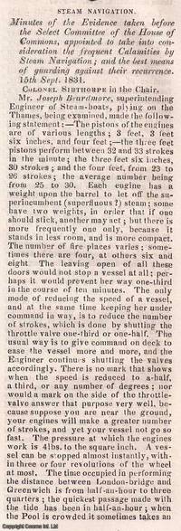
1831350541Knight and Lacey London 1831-32. Card Covers. Very Good Condition. The Mechanics' Magazine issues from November 1831 to January 1832 contained an extensive report on steam navigation accidents documenting the findings of a Select Committee of the House of Commons. This committee was formed to investigate the frequent calamities occurring in steam-powered vessels and to propose solutions to prevent future disasters. The report primarily written by Colonel Sibthorpe the committee chairman ran to approximately 70 columns and covered : Detailed accounts of steamship accidents including causes and consequences ; Technical assessments of steam engine failures and structural weaknesses in vessels ; Safety recommendations including improved boiler designs and operational protocols ; and economic and legislative considerations discussing the impact of regulations on steam navigation. These discussions were crucial in shaping early maritime safety regulations influencing the development of safer steamship designs and operational standards. The Mechanics' Magazine played a vital role in disseminating these findings to engineers shipbuilders and policymakers. The collection consists of the following seven complete issues: No. 433 Nov 26th 1831 to No. 439 Jan 7th 1832. Genuine Original and Packed with Innovation! This weekly magazine isn't just a fragment of history it's a window into the cutting-edge advancements of the Victorian era! Since 1823 The Mechanics' Magazine has tackled revolutionary topics from printing presses to vapor baths hydrostatics and hydraulics. It dives into breakthrough safety measures preventing explosive contaminated air while exploring the mechanics of oxy-hydrogen blowpipes and self-laying rail carriages. Every page crackles with Victorian-era engineering brilliance capturing the relentless drive for invention that shaped the modern world! This is an exclusive standalone issue carefully separated from its original volume; authentic original and uniquely crafted. It is not a reprint or reproduction but a distinct piece in its own right. Preserved in a modern card cover prepared for practicality - an unassuming but serviceable presentation that favours function over finery. Size: 13 x 21 cms. Category: Mechanics' Magazine; New Arrivals; This item may require more postage than the rates shown for delivery outside the UK. If extra postage is required we will contact you before processing your order and you will be given the details and option to decline the extra cost. Knight and Lacey unknown
19692082702114611746Shiroyama Do 1969. Soft Cover. Fine. Number of books: 1 Shiroyama Do paperback
1845114410Bristol: Philip Rose Printer. Very Good with no dust jacket. 1845. Unknown. Pamphlet. Original 1845 Printed Broadside for the Bristol Steam Navigation Company. "Steam Communication between BRISTOL and CARMARTHEN for TENBY & CARMARTHEN". Broadside measuring 11.3" x 9" 28.5cm x 22. 7cm with text typography and an illustration of the STEAMSHIP 'Phoenix' in black. In very good plus condition with a few small marks light creasing where previously lightly folded and a few tiny pinpoints to the top left corner by the first 'S' of steam. Some old faded writing relating to a trip on the ship on the verso which shows through slightly to the left side on the front. This Broadside reads: "Steam communication Between Bristol and Carmarthen For Tenby & Carmarthen The Bristol Steam Navigation Company's Fast and Splendid Steam Ship PHOENIX Lieut . T. Jackson R. N. Commander" Is intended to Sail as follows with Passengers Goods Live Stock etc. affording a most desirable and speedy Communication between the various Places in the County of Carmarthen and the Metropolis via Bristol and the Great Western Railway; also with Manchester and the North via the Gloucester and Birmingham Railway. ". Under this are the Dates and Times and Fares - Cabin 17s ; Children under 12 years of age 9s 6d ; Servants 11s 6d . Deck 8s; Carriage 42s ; Pair Horse Phaeton 31s 6d. ; . Dog 3s ; etc. Notice. - The Proprietors. Will not be accountable for any Cabin Passengers Luggage. Etc. " This broadside provides an interesting and most attractive record of U. K. Maritime Railway and transport history. A wonderful historical ephemeral item in great condition. See Images ; 4to 11" - 13" tall . Philip Rose, Printer, unknown
174845802Paris L'Imprimerie Royale 1748. 4to. Without wrappers. Extracted from "Mémoires de l'Academie des Sciences. Année 1744.". Pp. 462-774 textillustrations. <br/><br/><em>First printing of this importent paper in which Maupertuis proves that the Loxodromic line or Rhumbline is the shortest way between two points on the globe after he had proved by the measuring results that the globe is a spheroid. The paper is of great importence in the history of navigation. </em> unknown
192059233Washington D.C.: Government Printing Office Hydrographic Office U.S. Navy 1920-1930. Seven vols. 8vo. 4 365 1; 584; v 1 4 447 1 pp.; 2 22; 1; 2 57 1; 1 36 2 leaves. With 3 large folding colour maps numerous photo plates elevation views. Three uniformly bound in blue publisher’s buckram gilt lettering stamped on front covers & spines edgewear dustsoiling very slight uniform toning bowing to covers on vol. III some scuffing supplements all w/ self-printed softcovers edgewear rippling toning to fore-edges some predation still a G set w/ maps in bright condition. First editions stated of these uncommon coast pilot guides to Australian waters drawing upon British Royal Navy coast pilots Australian and U.S. Navy reports. Prior to modern GPS systems and satellite navigation these regularly updated and revised navigation handbooks provided key sailing instructions. The maps outlines the available charts for the designated areas surrounding Australia as well as those for the East Indies Pilot. First editions of these Hydrographic Office pilots are quite scarce and seldom seen with the supplements. Government Printing Office, Hydrographic Office, U.S. Navy, paperback
19068656Portland Oregon: The Oregon Railroad & Navigation Co. Fine with no dust jacket. 1906. First Edition. Original Wraps. Map unfolds to about 1 1/2'x5'. Colored semi-topographical map of the Columbia River with towns etc. Really cool!; Map; 4 1/2x9 1/2" . The Oregon Railroad & Navigation Co. paperback
19442005200040Houston : Gulf Publishing Co 1944. First Edition. Hardcover. Very Good. The Army Air Corps: A Rare and fine collection of the Army Air Forces in World War II. Log of Navigation. 7 issues bound as one. Bound in full blue cloth. Good binding and cover. Original pictorial wraps bound in. Clean unmarked pages. Numerous photographs maps comics. Heavily illustrated an interesting periodical. "The approved publication of the AAF Training Command." Includes: "A Camera Trip Through Army Air Forces School Hondo Texas" - a smaller photo-pamphlet; AND Log of Navigation issues: April 1944. Vol. 2 no. 4; May 1944. Vol. 2 no. 5; June 1944. Vol. 2 no. 6; July 1944. Vol. 2 no. 7; September 1944 Vol. 2 no. 9; March 1945. Vol. 3. No. 3. <br> From the former head of the U.S. Air Forces History Division. Houston : Gulf Publishing Co hardcover
2021x-981334668XSpringer Nature 2021. Hardcover. New. 362 pages. 9.25x6.10x9.21 inches. Springer Nature hardcover
181555781New York: Printed for Edmund M. Blunt Oct. 1815. 8vo. xvi 297 86 pp. plus 2 pp. publisher’s ads. Woodcut-engraved front of the Blunt New York Shop 9 of 15 maps & charts 1 w/ partial loss several w/ additional sailing instructions and printed notices pasted-in manuscript sailing instructions and notes on versos of some. Original calf spine & calf on rear cover perished shaken dampstaining & toning still fair reference copy from the library of Captain Thomas Hall II 1804-1829 son of Captain Thomas Hall 1778-1816 who was lost at sea while sailing from Charleston to Boston in Feb. 1829 which his brother Charles Hall 1810-1829 ownership markings on endpapers of both w/ manuscript note on verso of ffep. that this is “good for a pint of ale†facing clippings about new lighthouses ca. 1821 listing the Ten Pound Island stone tower light house first built on the site in 1821. Preserved in brick-coloured linen cloth clamshell slipcase w/ printed label on spine. Eighth edition of this early vital tool for American sea captains and navigators first published in a much shorter version of only 122 pp. in 1796 and the first edition to bear only Edmund Blunt’s name as author. The original commissioned from Captain Lawrence Furlong proved so crude and unusable that Blunt arranged for it to be edited and rewritten. Blunt’s Coast Pilots were the earliest works of their type published in North America to cover the Atlantic Coast of the U.S. with sailing directions tide tables tables of latitudes and longitudes and as this copy shows were often working evolving documents with additional manuscript annotations and printed additions including in this case the Charleston Harbour map which is not included in the binding instructions and supposedly left out of the 8th edition. Printed for Edmund M. Blunt, hardcover
193937919London: HMSO 1939. First Thus Printing. fair. 446 & 275 2-vol. set illus. some color diagrams maps index errata slip boards weak worn soiled and some edge tears. Ink notations and pencil erasures on front endpapers some page discoloration. This is an important snapshot of naval navigation practice at the eve of the Second World War. HMSO hardcover
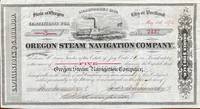
151860240Seattle WA & Portland OR; San Francisco: Oregon Steam Navigation Company OSN Lithographers Britton Rey & Co. May 15 1874. Oblong 8vo. 9.5 x 5.25 in. 1 lithographed stock certificate printed in red & black image of OSN sidewheeler decorative borders signed by Wygant Ainsworth & Thompson at lower fore-edge transfer printed on verso signed by Edwin M. Lewis to Mrs. Kate J. Jones w/ stamps of paid dividends in 1878 and 1880. A nicely lithographed and rare original stock certificate issued in 1874 by Jay Cooke and the Northern Pacific Railroad to raise money for OSN after many of its original stockholders had sold out in 1867 as the Company continued to compete with Ben Holladay’s Pacific Mail Steamship Co. Unfortunately OSN became entangled with the declining financial woes of the Northern Pacific to the extent that by 1879 Henry Villard representing German Bondholders in 1879 purchased the OSN paid off the certificate holders by 1880 and the company disappeared into Villard’s transcontinental railroad. Edwin Lewis in Shasta OR transferred this certificate to Kate J. Jones May 1 1875 and shows the stamps of being paid off in dividends when the Northern Pacific absorbed OSN’s four railroads 26 steamboats and real estate in Portland Astoria The Dalles Umatilla OR and Vancouver WA. Oregon Steam Navigation Company (OSN), Lithographers, Britton, Rey & Co., unknown
1839331758London: Smith Elder and Co 1839. Softcover. Good. First edition. Octavo. Disbound. 49pp. folding map. Lacking wrappers; title page and folding map detached from sewing; good. A scarce report establishes an early point for the English empire’s interest in establishing a steam boat line in India and the methods by which they proposed to go about doing so. Commercial manufacturers and various merchants from Manchester Liverpool and India were enlisted to support the proposal and the report outlines navigational routes estimations of cost and the enthusiasm of changing maritime trading methods up and down the Ganges. The idea for an East India Inland Steam Navigation Company apparently began percolating in 1837 and this report fits nicely within the small pantheon of material devoted to this literature. Not in OCLC. One copy found at the British Library. Smith, Elder and Co unknown
1939RiverPilot<p>HUDSON RIVER NAVIGATION <strong>Godfrey's river and canal pilot</strong>: <strong>useful information for masters pilots mates and yachtmen navigating the Hudson River New York State Barge Canals and Long Island Sound. Compiled by Daisy M and Frank H Godfrey. Rome NY: Republican Printing Company 1939. 8vo 33pp; blue textured paper covers lettered in silver a fine copy overall.</strong></p><p><strong>First and apparently only printing OCLC locating only two copies. Extensive listing of magnetic compass courseCayuga Ls including the Hudson River both North and South bound Oneida Lake Cayuga Lake Seneca Lake Erie Canal Oswego Canal Buffalo Harbor Long Island Sound and New Haven maint entrance to Stratford Point. </strong></p> Republican Printing Company paperback
1913DEMO016711INew York: Dodd Mead 1913. First American edition. Hardcover. Very Good. photos color plates maps. Octavos dark green cloth. 443 376 pages <br/><br/>Dogged by difficulties and beaten to the pole by Amundsen by a month then their luck turned Scott's second and last expedition to the Antarctic was to explore the Ross Sea area and to reach the South Pole. bad. There were no survivors of the polar party. Vol.1 is the Journals of Captain R.F. Scott. Vol.2 is the Reports of the Journeys and the Scientific Work Undertaken by Dr. E.A. Wilson and the Surviving Members of the Expedition. Abundantly illustrated the maps and plates are quite well done and deserve to be appreciated in the freshness and colors of the original. Dodd, Mead hardcover
1924185018Likely Shanghai: no stated publisher c.1924. First edition. Alongside notices amending and repealing existing directions the volume includes the text of four newly propagated and substantial documents concerning the ports of Amoy Yingkou Newchwang Wuhu and Qingdao as well as several non-maritime orders. This copy now deaccessioned was one of at least two sent to the Foreign Office Library in August 1924 by Judge Skinner Turner 1868-1935 the chief justice of the British Supreme Court for China from 1921 to 1927 Skinner's bequest is noted on the bookplate. The library's retained copy held in the FCDO Historical Collection at King's College London is the only other example we have traced. Octavo. Original buff boards brown cloth backstrip front cover lettered in black. Ex-Foreign Office Library with its date label and stamps on boards bookplate accession notation and withdrawal stamp. Covers and contents toned: very good. hardcover