4 résultats
1778234881London: printed for J. Mount T. Page and W. Mount 1778. The Second edition with an Appendix. Engraved title page chipped and defective 2 iii 1 86 pp. 1 vols. Small 4to. Original sewing with back wrapper only small chip at outer edge and stained first two leaves detached; engraved vignette title page waterstained and badly chipped with some loss to imprint. Still a remarkable survival of a rare and fragile book. The Second edition with an Appendix" Engraved title page chipped and defective 2 iii 1 86 pp. 1 vols. Small 4to. A Rare Manual of Navigation 1778. In his modest introduction Falck gives credit to the likes of Cornelius Douwes and Richard Harrison for inventing the method of determining latitude at sea by the use of solar tables. The appendix is a "Description of the Principles and Use of a plain Hadley's Quadrant and how to apply it in real Practice for taking a correct Altitude."<br/><br/>This second edition is much rarer than the first which was published in 1771. It is also a good fifteen pages longer. Falck would have been considerably buoyed by the involvement of Mount and Page one of the foremost publishers of maritime material in eighteenth century London. Especially as the first edition was published at his own expence. ESTCT 59664 British Library only; OCLC: 84682637 2 copies in US printed for J. Mount, T. Page and W. Mount unknown books
1747234865London: Printed for W. and J. Mount and T. Page 1747. Later approximately eleventh edition. Illustrated with woodcuts diagrams and tables. 272 pp. 1 vols. Small 8vo. Modern quarter blue morocco and cloth. Half-title and title leaves silked at upper margin early mild dampstaining to text; a good solid copy. Later approximately eleventh edition. Illustrated with woodcuts diagrams and tables. 272 pp. 1 vols. Small 8vo. First published in 1694 and innumerable times since throughout the 18th-century. Printed for W. and J. Mount, and T. Page unknown books
1773234857Edinburgh: Printed for the Author and for Geo. Robinson . and A. Donaldson 1773. First edition. 14 folding engraved plates numerous diagrams tables. xvi 2 errata 510 pp. 1 vols. 8vo. Contemporary brown calf red leather spine label. Small chip to upper right joint corners bumped; text slightly browned occasional light spotting. An attractive sound copy. First edition. 14 folding engraved plates numerous diagrams tables. xvi 2 errata 510 pp. 1 vols. 8vo. Printed for the Author, and for Geo. Robinson ... and A. Donaldson unknown books
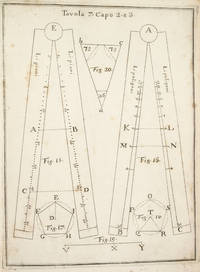
17533742NAPLES:: IGNAZIO RUSSO 1753. FIRST EDITION. Quarto:. 23.6 x 17 cm. 8 56 Collation: a4 A-G4. 15 engraved plates engraved by Filippo de Grado. Bound in contemporary vellum over boards. Foxing. Complete with the 15 engraved plates. Little is known of the author other than that he wrote another book on navigation in 1750. This work on the sector was translated into Spanish in 1758. By the time this book was published the design of the European sector had become standardized. Compare this design for example with that in the fourth edition of the works of Ozanam seventeen years earlier L’usage du compas de proportion 1736. The physical design of Pagnini’s instrument is better with pegs and decorative tenons to hold the two legs in alignment but the scales are essentially identical. The work is well illustrated with engravings showing exactly how a pair of dividers should be used to take the various lateral and transverse measurements. Pagnini provides eight tables that detail the exact markings for each scale. He also provides other material for reference use e.g. he includes not only a table for the construction of the line of metals but also one of their relative weights and their alchemical symbols etc. Tomash & Williams P7; Riccardi ii 236 IGNAZIO RUSSO, unknown books