20 résultats
170293hardcover. 4to cloth. Washington: U.S. Naval Hydrographic Office 1943. vg<br/><br/> unknown books
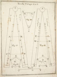
1778234881London: printed for J. Mount T. Page and W. Mount 1778. The Second edition with an Appendix. Engraved title page chipped and defective 2 iii 1 86 pp. 1 vols. Small 4to. Original sewing with back wrapper only small chip at outer edge and stained first two leaves detached; engraved vignette title page waterstained and badly chipped with some loss to imprint. Still a remarkable survival of a rare and fragile book. The Second edition with an Appendix" Engraved title page chipped and defective 2 iii 1 86 pp. 1 vols. Small 4to. A Rare Manual of Navigation 1778. In his modest introduction Falck gives credit to the likes of Cornelius Douwes and Richard Harrison for inventing the method of determining latitude at sea by the use of solar tables. The appendix is a "Description of the Principles and Use of a plain Hadley's Quadrant and how to apply it in real Practice for taking a correct Altitude."<br/><br/>This second edition is much rarer than the first which was published in 1771. It is also a good fifteen pages longer. Falck would have been considerably buoyed by the involvement of Mount and Page one of the foremost publishers of maritime material in eighteenth century London. Especially as the first edition was published at his own expence. ESTCT 59664 British Library only; OCLC: 84682637 2 copies in US printed for J. Mount, T. Page and W. Mount unknown books
40603OREGON RAILWAY AND NAVIGATION COMPANY. THE PACIFIC NORTH-WEST; A GUIDE FOR SETTLERS AND TRAVELERS: OREGON AND WASHINGTON TERRITORY. New York: Land Dept. Northern Pacific Railroad Co. 1882. 8vo. Printed wrappers. Frontispiece plate 81 pages. First edition. Scarce Western promotional travel guide to the Pacific North-West. Addressed prospective settlers and travelers alike this guide consists of historical geographical and agricultural information and discusses at length matters s as commerce climate education taxes prices and the regions of the Pacifi North-West. Each county is described and suggestions are provided to prospective emigrants such as "In mercantile pursuits the opening is good f men of enterprise and capital; but the chances for mere clerks are not good." Farm labor wages in these parts are recorded as being between $25 and $30 per month and lumber mills wages between $60 and $90 per month for first-class hands. It is also noted that "Chinamen work for the railroads and boards themselves at $1.00 a day and in winter take contracts for grubbing brush land." There are ten full-page illustrations which include a two-page "Bird's Eye Vi of Portland Oregon" "Saw Mill on Puget Sound W.T." "Astoria Oregon Entrance to Columbia River" "First Street Portland Oregon" and "Commercia Street Seattle W.T." with folding map of the region Unfolded 28 1/2 x 18 inches in the back. Spine and outer edges of wrappers sunned else good. unknown books
1747234865London: Printed for W. and J. Mount and T. Page 1747. Later approximately eleventh edition. Illustrated with woodcuts diagrams and tables. 272 pp. 1 vols. Small 8vo. Modern quarter blue morocco and cloth. Half-title and title leaves silked at upper margin early mild dampstaining to text; a good solid copy. Later approximately eleventh edition. Illustrated with woodcuts diagrams and tables. 272 pp. 1 vols. Small 8vo. First published in 1694 and innumerable times since throughout the 18th-century. Printed for W. and J. Mount, and T. Page unknown books
193742801London: Golden Cockerel Press 1937. Hardcover. Introduction and notes by Owen Rutter. Illustrations by Lynton Lamb. Complete 2-volume set. Tall 4to. Brown beige and green cloth with gilt spine lettering. 435pp 259pp. Four wood engravings two across each two-page title pages. Very good. Bindings a tad corner and edgeworn and rubbed though internally fine and tight. First of this edition a handsome set of this beautifully-produced pair by the legendary British fine press. Limited to 300 sets this #205. Scarce and lovely. Golden Cockerel Press hardcover books
181539889Lisbon: Simao Thaddeo 1815. hardcover. very good. 144pp. 8vo. Lisbon 1813. Second Edition. BOUND WITH: Taboa da Declinacao do Sol ao Meio Dia no Meridiano da Cidade de Lisboa . IV 64pp. 8vo full leather. Lisbon 1815. Scarce. Very good.<br/><br/> Tables of latitude and longitude for marine navigation.<br/><br/> Simao Thaddeo unknown books
187838742Brazil 1878. Broadside. A few small holes affecting a few letters some folds reinforced on verso additions in manuscript. 20 3/4x29 inches. The Companhia Nacional de Navegação a Vapor replaced the Companhia Brasileira de Navegação a Vapor as the government sponsored line along the southern route in 1872. Montevidio was the furthest stop of this important Brazilian shipping company from which it also provided river service to upper Brazil. The broadside contains a listing of the rates of passage from Rio de Janeiro to Montevideo as well as the limitations and restrictions for passengers which included a prohibition on weapons and flammable materials. unknown books
191827171Washington DC: Government Printing Office 1918. 326 pages; with two folding maps; the later separate Supplement is 11 pages printed on one side only. Front endpaper of the 1918 volume with the presentation stamp "From Frederick C. Hicks Congressman from Long Island." Frederick C. Hicks 1872 - 1925 U.S. Representative from NY and in that office from 1916-1923. Volume approx. 6" x 9 1/4" size; bound in the original cloth covered boards black cover & spine titles. Some edge tips wear & soiling to the binding; one map with closed tear; contents of book and supplement in good condition. First Edition. Hard Cover. Very Good. Government Printing Office hardcover books
182957255Washington: NP. Very Good. 1829. Paperback. Pamphlet disbound 20pp. some foxing good. 20th Congress 2d Session Rep. No. 62. Ho. of Reps. . NP paperback books
188025667New York City: Eastern Office Oregon Railway and Navigation Co.; Franklin Press: Rand Avery & Co. Boston 1880. 59 1 blank pp large 17" x 19" folding Colton color map of Oregon Washington Territory part of Idaho. A few short splits along folds with no loss. Original printed wrapperssoiled and worn. Scattered spotting. A few small chips and wormholes at corners of outer leaves closed tear to title page no text loss. Good.<br/><br/> "To meet the constant and increasing demand for full information as to the climate and resources of both Eastern and Western Oregon the present pamphlet is issued. In this compilation use is made of matter entertained in pamphlets issued by Oregon State Board of Immigration. The reader is given a few of the disinterested opinions of travellers map and tables showing all that may be desired in order to arrive at a correct knowledge of this state as gathered from Facts and Figures."<br/>Adams Herd 1729. Eastern Office, Oregon Railway and Navigation Co.; Franklin Press: Rand, Avery, & Co., Boston unknown books
199622915Erin: Boston Mills Press Stoddart. Fine in Near Fine dust jacket. 1996. Hardcover. 1550461656 . Black and white photographs throughout. First edition. Fine in a very near fine spot of edge wear at the top of the front panel dust jacket. . Boston Mills Press (Stoddart) hardcover books
185854442n.p. n.d. 1858. 8vo pp. 20; self-wrappers; fine. UC-Riverside and AAS only in OCLC. In 1855 while charting the Rio de Plata Basin the United States ship U.S.S. Water Witch was fired upon by a Paraguayan fort killing the helmsman Samuel Chaney. This outraged the U.S. government who along with the U.S. & Paraguay Navigation Company decided to bring the incident to the Supreme Court. In 1858 began the Paraguay Expedition the purpose of which was to demand an apology from the Paraguyan government and to address alleged insults against the Navigation Company. The result of the expedition was that Paraguay apologized the Chaney's family was indemnified and a new advantageous commercial treaty between Paraguay and the United States was forged. <br/><br/> unknown books
18471008098vo slate blue cloth stamped in gilt and blind illustrated with frontispiece and folding charts viii 21 429 3 24 pp.Wear to spine ends spine faded small splits to joints hinges cracked copious nautical notes to endpapers slight aging but text and charts are generally clean and unworn; about very good. This is rare first edition of what is known as "The Atlantic Navigator" which includes detailed sailing instructions for the North and South Atlantic. Includes ten folding charts and much of the text is from various captains and navigators familiar the routes contained in this work. The first numbered section of 21 pages is an 1847 supplement and the catalogue at the rear is dated 1851. Sabin noting 2300 only an 1854 fourth edition. James Imray, books
1883153130Washington DC.: Government Printing Office. 1883. hardcover. very good with no dust jacket; wear to extremities. 8vo. Government Printing Office. hardcover books
18966694Washington. Government Printing Office. 1896. Bound in gilt titled royal blue cloth. Square 8vo. First Edition. Mild scuffing to covers corners gently rubbed mild foxing to prelims. A Very Good copy. Government Printing Office. hardcover books
1868285943Washington: Government Printing Office 1868. Soft Cover. Very Good binding. The Bureau of Navigation Navy Department's booklet General Instructions for Hydrographic Surveyors. Dampstaining to the bottom edge of the second half of the textblock. Writing in ink on the front wrapper. Engraved plate of "Brooke's Deep Sea Sounding Apparatus" at the rear. Blue printed paper wrappers. Very Good. 62 pp. Very Good binding. Government Printing Office unknown books
1882130Washington D.C.: 1882. 32 plates in full color. Very good with light wear. hardcover books
1773234857Edinburgh: Printed for the Author and for Geo. Robinson . and A. Donaldson 1773. First edition. 14 folding engraved plates numerous diagrams tables. xvi 2 errata 510 pp. 1 vols. 8vo. Contemporary brown calf red leather spine label. Small chip to upper right joint corners bumped; text slightly browned occasional light spotting. An attractive sound copy. First edition. 14 folding engraved plates numerous diagrams tables. xvi 2 errata 510 pp. 1 vols. 8vo. Printed for the Author, and for Geo. Robinson ... and A. Donaldson unknown books
17533742NAPLES:: IGNAZIO RUSSO 1753. FIRST EDITION. Quarto:. 23.6 x 17 cm. 8 56 Collation: a4 A-G4. 15 engraved plates engraved by Filippo de Grado. Bound in contemporary vellum over boards. Foxing. Complete with the 15 engraved plates. Little is known of the author other than that he wrote another book on navigation in 1750. This work on the sector was translated into Spanish in 1758. By the time this book was published the design of the European sector had become standardized. Compare this design for example with that in the fourth edition of the works of Ozanam seventeen years earlier L’usage du compas de proportion 1736. The physical design of Pagnini’s instrument is better with pegs and decorative tenons to hold the two legs in alignment but the scales are essentially identical. The work is well illustrated with engravings showing exactly how a pair of dividers should be used to take the various lateral and transverse measurements. Pagnini provides eight tables that detail the exact markings for each scale. He also provides other material for reference use e.g. he includes not only a table for the construction of the line of metals but also one of their relative weights and their alchemical symbols etc. Tomash & Williams P7; Riccardi ii 236 IGNAZIO RUSSO, unknown books
183349821New York: G & C & H Carvill 1833. First Edition. Octavo. Original pebble-grained boards; paper spine title; 1-78-1582pp. Backstrip partially detached ; spine label faded barely legible; text fresh and unmarked - Good or better. Ex-U.S. Naval Lyceum with ink pressure stamp to endpapers and title page with de-accession dated 1927 on verso of title page. Pencil ownership inscription of a "Thos. J. Manning U.S. Navy" at head of title page. Verso of final text leaf prints a brief list of errata. G & C & H Carvill unknown books