87 résultats
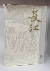
1980133049Shanghai 1980. First Edition. Hardcover. Good/Good. Unpaginated. 38 cm. 85 paintings of the Yangtze listed by author and described at rear. 56 are in colour. Blue hardcover in dustjacket. jacket has tears to edges. Book itself has shelf wear. Small ink notation on jacket flap. Ink inscription on brown front endpaper. Text in English and Chinese. <br/><br/> hardcover
1980BOOKS028140IShanghai:. VG unmarked 10 1/2" x 15" Hardback; DJ-G/VG 2 small taped. 1980. ISBN: tears. 85 Plates 56 color of Chinese paintings. Catalogs: CHINA. Keywords: CHINA YANGTZE RIVER CHINESE ART CHINESE PAINTING. hardcover
192059229Washington D.C.: Government Printing Office Hydrographic Office U.S. Navy 1920;1929. Two vols. 8vo. vii 1 4 500 pp.; 2 32 2 leaves. With 1 large folding colour map. First in dark blue publisher’s buckram lettering stamped on front cover & spine minor soiling edgewear slight uniform interior toning 2nd vol. in self-printed softcovers oxidized toning & predation to outer fore-edges front chipped corner still VG- set. First editions of these very scarce coast pilot guides to waters off the West coast of India just after World War I drawing upon British Royal Navy coast pilots and U.S. Navy reports. Prior to modern GPS systems and satellite navigation these regularly updated and revised navigation handbooks provided key sailing instructions often drawing not only from British & Indian sources but also sailing reports from U.S. Navy vessels and those from merchant ships. The map outlines the available charts for the coastline off of Bombay down to Cape Comorin the Maldives and Sri Lanka. Worldcat locates only 2 copies of the scarce supplement. Government Printing Office, Hydrographic Office, U.S. Navy, paperback
190139096Geneva: Press of W. F. Humphrey n. d. ca 1901. 1901. NEW YORK. First edition. 8" x 20" sheet folded to 10 panels pictorial black and yellow pictorial wrappers illustrated map. One side dedicates two panels to Watkins Glen and the Glen Mountain House Hotel and how to get there two panels provide description of the Glen Mountain House and its history and one panel tells of the Geneva Mineral Lithia Water Spring og Geneva N. Y. its discovery and introduction to the public. The other side dedicates two panels to the steamer trip on Seneca Lake one panel promotes the Nester Hotel in Geneva and its rates of $2.00 t0 $3.00 per day with information on how to reach Seneca Lake. The remaining two panels are the front and rear covers. An old water stain is at the upper portion and affects each panel to some degree and a tiny nick to bottom edge of front panel else a good copy Press of W. F. Humphrey, n. d. (ca 1901). unknown
197448469Bilbao: Servicio de Estudios de la Cámara Imp. Industrial 1974.- 4 VOLS. XXXI 600 p.; XVI 564 p.; VIII 499 p.; XIV 417 p. 1 h.: Profusión de estados cuadros ilustraciones y varios mapas plegados; 4º 24 x 167 cm; Cartulina Ed.- Ya RARO en el mercado. GEOGRAFÃA ECONÓMICA HUMANA Y ECONOMÃAS REGIONALES Libro en español Servicio de Estudios de la Cámara paperback
19692082702114611746Shiroyama Do 1969. Soft Cover. Fine. Number of books: 1 Shiroyama Do paperback
191236542North Yakima: Yakima Commercial Club 1912. 1912. WASHINGTON. 10 1/2" x 7" in color pictorial wrappers. 64 pp. introduction illustrations. Very brief history followed by extensive information on the Yakima Valley to include geography topography climate the Indian Reservation irrigation products produced methods of orchard development live stock dairying transportation communities industries etc. Numerous black and white photographs many full page photos of scenery residential homes buildings agriculture industries public buildings etc. Wrappers disbound from text. Light bleeding to first and last page wrappers lightly soiled and with chipping to top of front wrapper and with tiny fold to tops of page corners. Yakima Commercial Club, 1912. unknown
193731172Imray Laurie Norie & Wilson 1937. 4to. First Edition with frontispiece and plates; blue cloth gilt back a very good bright clean copy. This copy was formerly in the library of The Cruising Association and bears its bookplate on front paste-down and neat blind stamp on title. Traces the history of the firm of Imray and irs successors from 1670 to 1937. VERY SCARCE. Imray Laurie Norie & Wilson, hardcover
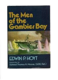
197936377Middlebury VT: Paul S. Eriksson 1979. Hardcover. Introduction by Thomas H. Moorer. Small 4to. Blue cloth spine and tan paper over boards pictorial price-clipped dust jacket. xii 254pp. Illustrations maps map endpapers. Fine/near fine. Tight attractive first edition of this surprisingly uncomon history of this World War Two aircraft carrier. Paul S. Eriksson hardcover
19137087Portland Oregon: Oregon-Washington Railroad & Navigation Co 1913. Fourth Edition. Stiff Illustrated Wrappers. Good. 8vo. Pp. 45 3. Frontis. scenic photograph. Illustrated with black & white halftone photo reproductions and one route map. Color illustrated wraps saddle-stapled. Light soiling and stains mellowed crease to back cover staples a tad oxidized trace of oxidized paperclip to head of the frontis. In sum a bright copy. Revised edition of the enticing 1911 tourism booklet lauding sites natural and man-made from Oregon to Alaska. Includes motoring tours and hiking in Mount Rainier National Park plus lakes and streams to cast the lure. The uncredited color illustrations are dreamy; the photography including a few shots by Asahel Curtis presents keen insight into early 1900s life in the Puget Sound Country. SMITH 7721.<p>Preserved in a removable clear archival pouch with acid-free backing. Oregon-Washington Railroad & Navigation Co unknown
192723896New Haven: Yale University Press 1927. Hardcover. Small 4to. Black cloth. xx 215pp. Frontispiece numerous illustrations. Very good. Slightest bit of edgewear and bit of "flecking" to the cloth but overall tight clean and attractive. First edition limited to 1000 copies. Interesting association copy for this belonged to the noted writer HAROLD BELL WRIGHT 1872-1944 one of the most popular novelists of the early 20th century author of such bestsellers as "The Shepherd of the Hills" 1907 "The Calling of Dan Matthews" 1909 and "The Winning of Barbara Worth" 1911 -- whose descendants parted with much of HBW's personal library in December 2005. Wright was a serious long-time boating enthusiast a fanatical follower of all things nautical whose hobby was designing and building from scratch his own sailboats. A rather uncommon title with an interesting provenance. Yale University Press hardcover
19068656Portland Oregon: The Oregon Railroad & Navigation Co. Fine with no dust jacket. 1906. First Edition. Original Wraps. Map unfolds to about 1 1/2'x5'. Colored semi-topographical map of the Columbia River with towns etc. Really cool!; Map; 4 1/2x9 1/2" . The Oregon Railroad & Navigation Co. paperback
198041070Annapolis: Naval Institute Press 1980. Hardcover. Small 4to. Blue cloth with gilt spine lettering pictorial dust jacket. xxii 448pp. Illustrations. Fine/near fine. A superb and tight first edition of this collection of biographical essays -- with choice autograph addition: Tipped to the front flyleaf is a 5" X 3" heavy stock card signed boldly in black ballpoint by Elmore R. Zumwalt n.p. dated 1986 September 4 in his hand. Fine. Zumwalt was the 19th and final of the naval figures discussed in this reference. Zumwalt 1920-2000 was the American navy's youngest four-star admiral ever and the commander in Vietnam who ordered the use of Agent Orange -- from which his own son contracted cancer. Zumwalt's original transmittal envelope is laid in as well. Naval Institute Press hardcover
1995biblio617Bethesda Md: Defense Mapping Agency Hydrographic / Topographic Center pub no 9 1995. Fine. <p>4to 873p ill maps full red cloth</p> Defense Mapping Agency Hydrographic / Topographic Center, pub no 9 hardcover
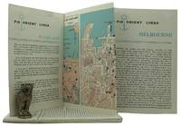
1962161834London: P&O Orient Lines 1962. Ten long single sheets folded into four five or six panels with text on one side and coloured maps on reverse the headings printed in blue & black; small cr. 8vo folded size; all numbered by hand near the top fore-corner of the upper panel with the number whited-out on number 2 Melbourne occasional slight soiling heavier on the Miami folder edges a trifle rubbed; P&O Orient Lines London 1962-1963. The folders were 'produced to assist passengers' and contain a brief history and description of each city including places of interest hotels shopping theatres currency information etc. P&O Orient Lines unknown
1941Alibris.0024602Washington: U S DEPARTMENT OF COMMERCE 1941. Trade paperback. Good. No dust jacket. Signed by previous owner. CONTENTS; TANK VESSELS-GENERAL PROVISIONS-INSPECTION AND CERTIFICATION-REQUIREMENTS FOR HULLS MACHINERY AND EQUIPMENT-LIFE SAVING APPLIANCES-FIRE FIGHTING EQUIPMENT-OPERATION-LICENSED OFFICERS AND CERTIFICATED MEN-SPECIFICATIONS FOR LIFE SAVING APPLIANCES-TRANSPORTATION OF LIQUEFIED INFLAMMABLE GASES. INDEX U S DEPARTMENT OF COMMERCE paperback
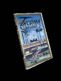
19118633Tacoma: Tacoma Commercial Club and Chamber of Commerce 1911. First edition. 14x8cm 32pp. Full color and sepia photographic illustrations throughout. Single map. Detachable post card/order form present at rear. Staple bound in color lithographed card covers. Some edge rubbing and light wear else near fine. <br /> <br /> Beautiful and scarce promotional booklet a joint effort of the Oregon-Washington Railroad and Navigation Company Bureau of Community Publicity and the Tacoma Commercial Club and Chamber of Commerce. Photos of prominent buildings factories the port Mount Rainier and Stadium High School among others. Includes information on industry and culture of the fast-growing city. <br /> <br /> <br /> OCLC cites 4 holdings only including just 1 in the state of Washington. . Tacoma Commercial Club and Chamber of Commerce unknown
192759236Washington D.C.: Government Printing Office Hydrographic Office U.S. Navy 1927-1930. Three vols. 8vo. x 4 550; viii 4 560 pp.; 1 17 2 leaves. With 4 large folding colour maps 1 w/ toning at fore-edge from being improperly folded some edgewear numerous plates showing lighthouses. Two volumes uniformly bound in red publisher’s cloth gilt lettering front cover & spine darkening to spine fore-edges minor shelfwear dustsoiling minor paint drip at fore-edge 1 vol. Supplement in self-printed softcovers edgewear toning to fore-edges minor predation still VG- set. Third editions revised & updated of vols. I & II first edition of scarce Supplement of these coast pilot guides to South America and Antarctica in the 1920’s. Prior to modern GPS systems and satellite navigation these regularly updated and revised navigation handbooks provided key sailing instructions often drawing not only from Brazilian Argentine and British coast pilots as well as sailing reports from U.S. Navy vessels and those from merchant ships. The first large map delineates the requisite coast pilots for sailing in American waters and charts to be ordered from the Hydrographic Office while the second maps depict the sailing routes. The expanded 3rd edition is quite scarce with 1 copy located of both vols. in Worldcat NYPL. Government Printing Office, Hydrographic Office, U.S. Navy, paperback
1905100722Montreal: Desbarats & Co. 1905. Book. Good. Original Wraps. 8vo - over 7¾" - 9¾" tall. Title continued: With many illustrations of interesting places and scenes also a short description of the Ottawa River and points of interest to the tourist who may make the trip via the Grand River and Rideau Lakes through the most charming scenery in America between Montreal Ottawa and Kingston. 56 p. Folding map - Route of the Ottawa River Navigation Co. 35 illustrations. Covers worn with chips in spine. Top corner stained. A scarce guide book. Desbarats & Co. Paperback
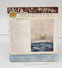
1934155424Sydney Australia: Printed by John Sands Ltd. 1934. Staplebound. Good. 12 p. 24 cm. Stapled. Colour illustration on back and front. B&w photos within. <br/><br/>K.P.M. lists its head and branch offices throught the world illustrates its ships deck diagrams gives timetables general notes itineraries. Printed by John Sands Ltd. unknown
196938798Santa Barbara CA: Coast Navigation School c1969. Black-plastic covered case. Good. Instructional kit for sailing navigation; includes 8 x 8 plastic navigation wheel for calculating speed time and distance and verso plastic Simex Course Converter wheel to find true course from compass bearing with instructions both in black plastic 9 x 9 carry-case plus unmarked folded navigational training map plus hinged parallel rulers tool 12 right-angle tool 360-degree round tool 7-in German steel calipers - all in black hard carry-case. Very good usable conditon. Rare item. <br/><br/>Carry-case case is 9-1/2 x 15 map is 8 x 11 folded 32 x 22 unfolded. Coast Navigation School unknown
1913DEMO016711INew York: Dodd Mead 1913. First American edition. Hardcover. Very Good. photos color plates maps. Octavos dark green cloth. 443 376 pages <br/><br/>Dogged by difficulties and beaten to the pole by Amundsen by a month then their luck turned Scott's second and last expedition to the Antarctic was to explore the Ross Sea area and to reach the South Pole. bad. There were no survivors of the polar party. Vol.1 is the Journals of Captain R.F. Scott. Vol.2 is the Reports of the Journeys and the Scientific Work Undertaken by Dr. E.A. Wilson and the Surviving Members of the Expedition. Abundantly illustrated the maps and plates are quite well done and deserve to be appreciated in the freshness and colors of the original. Dodd, Mead hardcover
192059238Washington D.C.: Government Printing Office Hydrographic Office U.S. Navy 1920; 1930. Two vols. 8vo. viii 4 577 1 pp.; 1 38 1 leaves. With 1 large folding colour map. 1st vol. in green publisher’s buckram gilt lettering stamped on front cover & spine darkening to spine shelfwear deep embossed circular indentation at gutter margin where brass weight held book open; 2nd vol. Supplement in self-printed softcovers toning chipping & tears to spine still G set. Second edition stated of vol. I 1st edition of Supplement vol. of these surprisingly scarce coast pilot guides detailing the sailing directions for the treacherous coasts of Norway & Sweden notoriously treacherous for sailing and powered vessels. Prior to modern GPS systems and satellite navigation these regularly updated and revised navigation handbooks provided key sailing instructions drawing upon British Norwegian Swedish & Danish coast pilots. Worldcat locates only 1 copy of the Supplement U of W. Government Printing Office, Hydrographic Office, U.S. Navy, paperback
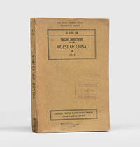
1943172166Washington DC: United States Navy Department Hydrographic Office 1943. First edition first printing pleasingly with all the printed supplement tickets still present and the detailed maps well preserved. Updated chapters offer information on general subjects such as pilotage storm and weather signals quarantine regulations and ocean currents as well as detailed discussion of stretches of river and ocean along China's east coast down to Hong Kong and up the Yangtze. While common institutionally as expected copies are now seldom encountered in commerce. Octavo. With 2 folding maps 2 diagrammatic plates illustrations in text. With all 8 leaves 4 blank of printed supplement tickets bound in at front as issued. Original brown card wrappers spine and front cover printed in black. Ex-Civil Affairs Training School University of Chicago with its ink stamps on front cover and "discard" noted in pencil. Wrappers well preserved first map with stub tear just touching neatline second map split along one fold neatly repaired on verso with archival tape couple of small nicks and chips internally not affecting text: a very good copy. unknown
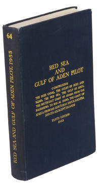
1955ABC_47446London 1955. 8vo. Published for the Hydrographic Department Admiralty Original blue cloth with yellow lettering on the spine and the front board the supplement is loosely inserted at the end of the volume: original printed paper wrappers stapled. With a folding map printed on both sides 2 coloured plates with diagrams printed on both sides 28 plates showing coastlines and occasionally a map many printed on both sides and many some illustrations in text. 2 LI = LIII: II plus 1 1 blank 1 blank 518 1 1 blank pp; Supplement: 20 pp. The essential standard sailing directions for the Red Sea and Gulf of Aden corresponding with zone NP64 on the official Admiralty charts. These nautical works - pilot guides and charts - were published by the United Kingdom Hydrographic Office which provides the necessary hydrographic and marine geospatial data to all kinds of maritime organisations across the world. The publications are not only used by the British Royal Navy but can also be found on board the majority of international merchant ships. The data provided in the pilot guides and other publications are compliant with SOLAS the Safety of Life at Sea treaty guidelines and are updated constantly in weekly "Notices to mariners" and supplements to and new editions of the pilot guides whenever necessary.The present copy is the 10th edition 1955 of the pilot guide with sailing directions and other information on the weather currents radar ranges etc. relating to the Red Sea and Gulf of Aden including the supplement issued in 1957. It includes an erroneous "advertisement to the eight edition" by the Hydrographer of the Navy Rear-Admiral Kenneth St Barbe Collins 1904-1982. The advertisement states that with the publication of "the ninth edition" presumably this volume the previous edition and its supplements are cancelled since the most up-to-date information has been compiled in the new edition and the weekly "Notices to mariners" that appeared after the publication of the 11th edition. The 10th edition of 1955 and its 1957 supplement were made redundant with the publication of the 11th edition in 1967. Each subsequent edition of the pilot supersedes the last which have appeared infrequently depending on newly available information from the mid-19th century until the present day.The front paste-down and recto of the first free endpaper contain a "caution" notice and room for the notation of "supplements and annual summaries of notices to mariners relating to this book" the first two pages are printed on red-pink paper. The binding shows minor signs of wear around the spine and corners of the boards the gutter after page II is somewhat weakened the head edge of the wrappers of the supplement are very slightly browned. Otherwise in very good condition. hardcover