474 résultats
197965988United States 1979. Presumed first edition/first printing. Hardcover. Very good. No dust jacket. viii 801-1333 p. Includes: illustrations diagrams. Volume 2 ONLY. This sumposium was cosponsored by the Defense Mapping Agency and the National Ocean Survey. It was hosted by the Aplied Research Laboratories and held at the University of Texas at Austin. Volume II includes Session IV on Terrestrial Adjustments Session V on Advanced Systems the Closing Session and the Symposium Scrapbook of photographs countries representated and the list of attendees. United States hardcover
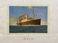
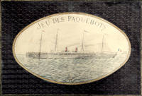
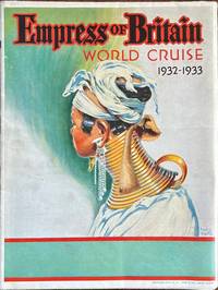
193260328Montreal Canada & Liverpool UK: Canadian Pacific 1932. 4to. which opens into Double Atlas Folio. 42 x 50 in. colour-illustrated on recto and verso with large colour deck plans delineating decks amenities cabins for 1st class and Tourist Class folding map at lower portion indicating the route large colour plate of Empress of Britain on verso numerous photo illustrations. Self-printed colour-illustrated softcovers striking cover art of Southeast Asian woman with neck elongated by gold rings front & back by Frederick J. Hoertz minor edgewear light creasing to folds very slight closed tears at a couple folds still VG bright copy. First edition of this very uncommon and large deck plan for the famed Empress of Empress of Britain a 42000 ton ocean liner specifically built and constructed with double-hull construction for the Northern Trans-Atlantic Route between Quebec and the UK who entered service in 1931. She was the first cruise ship designed for Winter routes when the St. Lawrence River was frozen and when converted for her Round the World cruises she was converted with more luxury cabins. At the height of the Great Depression and following a price increase only 283 passengers sailed in the 1932-1933 Round the World Cruise with 100 leaving the ship in India. Notables included Baron F. De Marwicz 1907-1990 hockey player who led England’s National Team in the 1930 & 1934 World Championships Sir Walter Preston 1875-1946 inventor & engineer Cornelius Vanderbilt IV and famed British author George Bernard Shaw with his wife Charlotte who spent most of the cruise writing rather than taking the port excursions. No copies located in Worldcat of this giant version 2 copies located of smaller piece at Wolfsonian measuring 10 x 11.5 in. Canadian Pacific, paperback
195557750Paris France: Imprimerie Transatlantique 170 bis rue de charonne 1955. 4to. 9.5 x 12.75 in. 20 pp unpaginated. colour-printed throughout which folds out into 46.5 x 25 in. colour poster w/ photo illustrations text and double-page pictorial map on recto. Colour-illustrated softcovers w/ porthole image of the SS Antilles minor creasing to one corner still NF copy. First edition of this marvelously illustrated cutaway deck plan for the SS Antilles which had been completed in 1953 and eventually was placed on the West Indies Cruise service. The SS Antilles or her sister ship the SS Flandre appeared in the stock footge in the 1964 Perry Mason television episode “Nautical Knot†set near Acapulco Mexico. The double-page pictorial map showing her stops in the West Indies was executed by R. Bonnard. The ship hit rocks and caught fire in Lansecoy Bay in 1971 and all were evacuated to the island of Mustique and later rescued by the Queen Elizabeth 2. Imprimerie Transatlantique, 170 bis rue de charonne, paperback
AManPro4FE3-0003696Captain Trip. Audio CD. Used - Very Good. 0x0x0. Very good condition. Comes from non smoking home Captain Trip unknown
Hagman, Tore and PhotograIn Pristine Condition. unknown
2018L3 box714 a1The Future of Ocean Governance and Capacity Development: Essays in Honor of Elisabeth Mann Borgese 1918 - 2002. Edited by International Ocean Institute - Canada. 2018 by Koninklijke Brill NV; Brill Nijhoff. Hardcover 592 pages. Koninklijke Brill NV; Brill Nijhoff. hardcover
2012x-019991589XOxford Univ Pr 2012. Hardcover. New. 602 pages. 9.13x6.57x1.10 inches. Oxford Univ Pr hardcover
2025x-1032745037Routledge 2025. Hardcover. New. 272 pages. 9.00x6.00x9.24 inches. Routledge hardcover
192557372Bremen: Norddeutscher Lloyd Bremen North German Lloyd Hofbuchdruckerei H.M. Hauschild 1925. Oblong 4to. 48 pp unpaginated. With colour frontisp. numerous photo plates decorative borders in green ink. Colour-illustrated softcovers cover art of the Brandenburg Gate in gilt blue blue & gilt borders globe logo at upper fore-edge dustsoiling shelfwear still VG copy. First edition of this scarce ocean liner promotional brochure for the SS Berlin built by Bremer Vulkan and commissioned in Sept. 1925 making the North German Lloyd Run from Bremen - Southampton - Cherbourg - New York. She would make runs until chartered by the Nazi Party in 1939 as a Party Cruise Ship and converted to Hospital Ship during World War II. These photographs show such amenities for first class passengers as spacious promenades salons writing room library nicely appointed staterooms and exercise gym. The accommodations for 2nd & 3rd Class passengers were decidedly poorer. The ship was salvaged by the Soviet Union in 1949 and served as the Admiral Nakhimov a cruise ship transported soldiers to Cuba during the Cuban Missile Crises was later rammed and sunk by the Soviet freighter Pyotr Vasev and 423 of the 1234 on board perished. Norddeutscher Lloyd Bremen, North German Lloyd, [Hofbuchdruckerei H.M. Hauschild], paperback
2019006211UK: Royal Academy of Arts. A Superb UK First Edition & First Printing large format paperback original - The first monograph to bring together works by the artist Humphrey Ocean RA from the early 1970s to the present day with an extensive essay by the art historian and curator Ben Thomas - All my books are always securely packed with plenty of bubblewrap in professional boxes and promptly dispatched within 2-3 days - SIGNED BY HUMPHREY OCEAN - Pictures of the book are available upon request. . Fine. Soft cover. 1st Edition. 1st Printing. 2019. Royal Academy of Arts paperback
1882143690Washington: United States Hydrographic Office 1882. Fair. Washington United States Hydrographic Office 1882/ 1868 and 1869. A very large engraved chart in two sheets combined size approximately 940 × 1230 mm overall total size 954 × 1252 mm with minimal hand-colouring mounted together on linen. Some foxing and light soiling with a few light stains and creases and trifling surface loss from insect damage; light wear to the edges; verso of the linen backing a little waterstained; overall a working map in decent condition. A large United States Navy Hydrographic Office chart with five inset charts showing the anchorages of Walwich Bay Walvis Bay Angra Pequena Lüderitz Bay and St Helena and channels through the Abrolhos and Manoel Luiz Banks. The two sheets incorporate corrections to December 1881 and January 1882 respectively. <p>Pencil annotations show the tracks of three voyages two south-east towards the Cape of Good Hope in March-April and November-December 1883 and one in the opposite direction in April-May 1886 this is identified in the right-hand margin as part of a voyage from Hong Kong to London made by one J.B. Newcomb. A further partial track is given in purple ink dated only 'Route in October November and December'. Lighthouses are highlighted with spots of red and yellow colouring. United States Hydrographic Office unknown
1879365174Published by Order of the Association 1879. First Edition. Illustrated throughout folding map. 88; 24; 45 2; 40;40; 39 1; 50pp. 8vo. Half brown morocco spine sunned. First Edition. Illustrated throughout folding map. 88; 24; 45 2; 40;40; 39 1; 50pp. 8vo. With 10 Annual Reports. The Fifth -Tenth with seperate title-pages and pagination. Published by Order of the Association unknown
17083Paris Unesco 1965-1972; Hamburg Deutsches Hydrographisches Institut 1972. Eight parts and Index in nine. 4to 27.0 x 21.0 cm 7967 pp. I1965: xvi 915; II1966: ix 672; III1966: ix 984; IV1967: x 867; V1968: ix 834; VI1969: ix 1389; VII1971: x 1275; VIII1972: x 833; Index1972: 116; numerous text figures tables and maps. Uniform original printed wrappers. = Rare complete set of one of the main sources of information on the oceanography zoology mainly fish but also crustaceans molluscs etc. botany geography economic resources etc. of the Indian Ocean including the Persian Gulf Bay of Bengal and south to Madagascar and Kerguelen. The subjects are grouped under the following chapters: Marine Biology Marine Chemistry Physical Oceanography and Marine Meteorology Marine Geology and Geophysics Cruise and General Reports together with papers presented by title only. A massive set. Rarely found complete. The index is identical in size and wrapper layout but published in Hamburg. Printed compliments card from UNESCO loosely inserted. Numbers or label on foot of spines small stamp on half-titles; otherwise a very good set. The last volumes and index are rare. unknown
198250512London: MPL Publ. 1982. First Edition; First Printing. Hardcover. Scarce collection of drawings by artist Humphrey Ocean documenting the McCartney/Wings 1976 tour; near fine in glossy illustrated boards no dust jacket as issued; minor bumping to spine ends else a tight square unmarked copy in sound binding; first printing with no later statements; photos on request . MPL Publ. hardcover
1790143934Paris: F. Dufart 1790. Very Good. Paris F. Dufart circa 1790. A hand-coloured engraved map printed surface 378× 415 mm sheet size approximately 420 × 540 mm. 'Gravée par Tardieu l'Ainé . Dessiné par Poirson . Ecrit par Beaublé'. Original folds as issued; some minor uneven tanning; in very good condition. An uncommon chart of the Pacific Ocean and Australia showing magnetic variation and dip drawing on observations made in the course of Pacific voyages after 1775 most notably Cook's third voyage. It is most likely from a duodecimo edition of Buffon's 'Histoire naturelle générale et particulière' around the end of the eighteenth century 'PL. III. Tome XVI' and 'Page 58' are printed in the top margin. It is based on a larger chart in four sheets attributed to Jean-Charles de Borda. The engraver Tardieu is one of half a dozen members of the family working as engravers at the period one of whom P.A.F. Tardieu would engrave the charts published in the official account of the Baudin voyage. F. Dufart unknown
179750776A Geneve Biblioth. Britannique 1797. 8vo. Contemp. marbled boards. Paperlabel with handwritten volume- title on spine. Boards rubbed. In: "Bibliotheque Britannique" Tome cinquieme. Sciences et Arts. A name cut from titlepage no loss of letters. Entire volume offered. 392 pp. 4 folded tables a. 3 folded engraved plates. A faint dampstain to foot of titlepage otherwise clean printed on good paper. Rumford's paper: pp. 97-200 a. 1 engraved folded plate. <br/><br/><em>First printing of the founding paper on Oceanography describing the experiments leading to the discovery of the convection currents in the sea. Cold water at depth in the tropics implies a meriodinal circulation transporting deep water from the polar regions towards the equator. Water cooled at the surface in high latitudes gets denser and hence descends. Parkinson "Breakthroughs" 1797.The volume also contains the first translation of any part into French of JAMES HUTTON "Theory of the Earth &c. Théorie de la Terre avec des preuves & des éclaircissemens; en guatre parties. 1.-2. Extrait.". Pp. 53-73 a. pp. 262-273. </em> hardcover
1940180382February - October 1940. An attractive collection exhibiting the continuation of relatively comfortable commercial sea travel in the early years of the Second World War before the Japanese government requisitioned large numbers of O.S.K. and N.Y.K. vessels for military use. The menus supplement a predominantly Western style of cuisine with occasional Japanese titbits. Passengers on the Brasil Maru were treated to musical performances while they dined. 10 items octavo. Original colour or monochrome card covers 7 with letterpress bifolium fixed with colour string 3 with contents printed direct 1 of these formed from sheet folding into quarters. Light wear especially to largest examples foxing and a little soiling: a very good collection. unknown
8449413087New. Brand new and still unused unknown
8449406986New. Brand new and still unused unknown
1851PACIFICO015869Longman Brown Green and Longmans London. 1851. First edition. Octavo. Two volumes in one: pp xii 352; xii 371. Four chromolithograph plates. Original blue cloth decorated in blind lettered in gilt.On the front free endpaper are two 19th century inscriptions one of which has been crossed through. Some foxing here and there. Head and tail of spine a bit scuffed. Some wear to edges. Very good. Very scarce in the intact publishers' binding. Longman, Brown, Green, and Longmans, London. hardcover
190955870n.p.: Mr. & Mrs. Rutherford 1909-1910. Oblong 4to. 11.5 x 7.5 in. 46 pp unpaginated. on thick gray card stock mounted on green linen hinges at gutter margin. With 56 silver gelatin & albumen photographs 3 hand-coloured 1 RPPC sized from 2.5 x 4.25 in. up to 6.75 x 9.75 in. several of the photos have descriptive text w/in the negative at lower margin some w/ lettering in manuscript below the images; seating chart for dinner with the Viceroy two ALS invitations on letterhead dance card menu and clipping touting the attendees. Recent leather post-binder lettering stamped on front cover occasional fading to a few images some albumen photos w/ wrinkling from being applied to boards occasional edgewear couple minor tears still a VG exemplar; Nine albumen photos sized from 7 x 9.25 in. up to 8.5 x 11 in. uniformly mounted on 11 x 14 in. gray studio board and 8 of the 9 w/ manuscript notes in bold hand on versos minor edgewear a few corners w/ minor wear still a VG set of images. This intriguing souvenir album for a voyage on the SS Prinzess Irene through the Mediterranean and onto India and Singapore opens with photos on shipboard of the Rutherfords and Miss Weir with their small dog companion. They have incorporated three albumen photos of Naples including a panoramic view of Naples St. Martin’s Charterhouse the Neapolitan Monastery and Santa Lucia street. Additional views on shipboard as they sail to India including a view of camels and desert dunes along the Suez Canal. Upon their arrival in Calcutta India they are invited and attend a state diner with Sir Syed Hussain Ali Bahadur b. 1875 the Nawab of Murshidabad two Maharaja’s British officers and Baron Charles Hardinge Viceroy of India with menus and invitation included and a mounted hand-coloured view of the Nawab. The menu featured Filets de Canetons au Foie Gras Mousses de Volaille Petits Rolls Mayonnaise Plum Cake Bavarois Chocolat Pistache and Macedonian Champaign while the musical accompaniment featured old favorites of Teddy Bear’s Picnic Die Meistersinger by Wagner ballet music from Faust and compositions by Rosse. Street scenes of markets native dress elephants owning the road as well as several different wagons pulled by horses camels and oxen. Also included are albumen views of pilgrims washing in the Ganges at Benares Varanasi Hawa Mahal or Palace of the Winds at Jeypore street scene in Jeypore depicts oxen market buildings by Bourne & Shepard whose images were marketed throughout India by agents and wholesale distributors. From there the trio voyage onto Singapore shown in images of Kampong Bugis along the Kallang River with a native in their boat with thatched homes built on stilts; a bustling port views along palm tree lined streets a bustling market scene elephants washing as well as a particularly striking scene of oxen pulling a large loaded woven cart. The nine separate views include albumen photos of the entrance gate to the Taj Mahal a detail shot the inner courtyard and screen around the the tombs of Shah Jehan and Mumtaz Mahal three striking and large albumen photos of the Thanjavur temple site including the Brihadishavara Temple and the monumental Gopuras gateways and finally the Pearl Mosque. The SS Prinzess Irene was an 18000 ton lier launched in 1900 for North German Lloyd was seized in 1917 in the United States renamed the USS Pocahontas and eventually sold back to North German Lloyd in 1922 first renamed the Bremen and then the Karlsruhe and sailing until 1932. Mr. & Mrs. Rutherford, hardcover
200877505Harry N. Abrams Distribution. New. 2008. Paperback. 1905711123 . FREE UPGRADE to Courier/Priority Shipping Upon Request - IN STOCK AND IMMEDIATELY AVAILABLE FOR SHIPMENT - Flawless copy brand new pristine never opened -- Text in English. 192 pp. With 218 ills. 211 col. . 24 x 20 cm. -- with a bonus offer-- . Harry N. Abrams (Distribution) paperback
18972210164<p><i>Comprising two coloured map board 66 x 99 cm folding down to 32.5 x 49.5 cm one cloth hinge broken; 14 route cards; a barometer dial 19 x 19 cm with gilt metal spinning arrow some abrading from use; eight painted white metal playing pieces in the form of ships contained in the original small box one piece not original; 16pp booklet of instructions bound in original light green printed wrappers; all contained in the original box 35 x 52 x 5 cm; the hinged lid with a large coloured lithograph title label showing the 'Normandie' leaving port at full steam some minor abrasions but overall in good condition.</i><br /></p><p><i>Jue des Paquebots</i> was something new to games when it was published in 1897 as each player moves their boats on large maps exactly replicating the routes taken by two major French shipping lines. </p><p>The game includes two large folding boards designated 'Carte A' which illustrates the Atlantic shipping lines the other 'Carte B' with the shipping lines leaving Marseilles in the direction of the Black Sea the Indian Ocean and the Pacific. Rather pointedly the instructions state that the two maps include only the French shipping lines of the Messageries Maritimes and the Cie Générale Transatlantique the United Kingdom then the leading maritime nation is neither shown on the maps nor mentioned. </p><p>The players first decide which map they are going use and then select or bid one of the Itinerary cards 8 for map A and 6 for map B. The aim of each player is to complete the journey indicated by their itinerary and then make the return voyage; the first player to complete this double crossing wins. However the number of stopovers is not equal for each different itinerary in play. In order to equalise the chances of winning the players with the fewer ports of call have to repeat their journey a second or even a third time if necessary until the number of ports visited or passed by them in these different routes equates to the number of ports of the busiest route.</p><p>The routes all follow those which the two major French shipping companies plied. These include final destinations at Yokohama Australia New Zealand Zanzibar Odessa Buenos Ayres New York and the Antilles. </p><p>Each player places a ship playing piece at port at the beginning of their route. The first player now spins the Barometer Dial which has outer and inner instructions that allows them to advance out of port when their turn come around again the arrow is again spun and the player can read the inner line of instructions and so advance 1 2 or 3 ports along their route. However there are also stops on the Barometer Dial that include Damage - where you go back to the previous port and pay a token to the bank; Heavy Fog - where you are left stranded until the next round; Collision - this allows another turn of the dial but it the result is 50/50 chance of being sunk and thrown out of the game - you can pay for another ships so all is not lost; Call for Distress - also misses a turn; Shipwreck - something like collision although you can start out again with a new ship and no fine; Rescue - also causes the player to miss a turn; lastly and somewhat topical there is Quarantine - here the player misses a turn and also has a second spin of the arrow to determine if you can go into port or not.</p><p>The lid of the box illustrates the Cie Général Transatlantique liner La Normandie that plied the North Atlantic to New York in the summer and the south Atlantic in the winter - the ship sports a US flag on the foremast and the makers initials on the aft mast. Built in 1886 it was the largest and fastest liner of the company and was originally named 'Ville de New York.' It was also lit by electricity and could carry 1000 passengers and became the model for several sister ships built to the same plan.</p><p>The maker Charles Watilliaux succeeded the games manufacturer Coqueret in 1874 and for the next 35 years became a major publisher and manufacturer of board games and toys until their acquisition by Revenaz & Tabernat. His registered initials were 'W.X.' which is slightly modified for the flag on the box lid as C.W.X.</p> Watilliaux, éditeur.
1755ABC_474521755. Manuscript of 24 pages 6 printed maps on cardboard. This wonderful logbook details the journey of a French captain from Manila to the Maluku Islands in todays Indonesia. The journey took place during the months of March to May of 1755. The captain of the ship recounted with great detail the events of every day of the journey with detailed daily accounts of the weather winds manoeuvres of the ship its departures anchorages and precise coordinates at every point of the journey. The captain furthermore had a keen eye for the geographical and nautical details along the journey. He recounted the exact locations of for example sandbanks and bays where ships and their crews can take provisions and fresh water. The accounts are detailed and captivating: "After our boats were back on board we set sail . in the afternoon to moor under the old Portuguese fort on the Solor island Indonesia the winds for the tide were fresh at 1:34 a.m. . sand and gravel and then I went back to mooring. The pavilion of the fort . the village is under the said fort at 3 cables from us .". The captain goes on to describe the geographical features of the islands as well as other places en route with great detail. Curiously we find inscriptions in Spanish and the names of one don Phelipe Qui who describes himself as el piloto and one Padre Don Estevan de Melo. The latter might be identical with Don Estevan Roxas y Melo a native of Lima Peru and secretary to the Archbishop of Manila Rodriguez since 1736. Roxas y Melo was part of the 1751 reconstruction of the Cathedral of Manila working under the auspice of the Italian architect Juan de Uguccioni.The logbook comes with six printed maps partly illustrating the journey of the captain pasted on contemporary cardboard. They depict the Bay of Sulavesi with the city of Bantang Pitcairn the coast of New Guinea the coast of Queensland the Santa Cruz Islands in the present-day Solomon Islands and Alejandro Selkirk Island. The plates stem from the French translation of James Hawkesworths An Account of the Voyages Hawkesworth Relation des voyages entrepris par ordre de sa Majesté Britannique actuellement regnante; pour faire des découvertes dans l'hemisphère meridional Paris 1774.Some holes on the first sheet not affecting the text. Small water damage some slighlty affecting the text. Remnants of seals on last page. Otherwise in good condition. unknown