INDIA - LINDEMAN & COBiblio.com
221 résultats
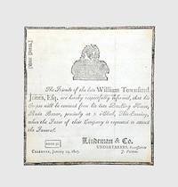
1807122432Calcutta: Star Press 24 January 1807. Haunting piece of Company-rule ephemera announcing the funeral of William Townsend Jones c.1757-1807 attorney on the council of the Supreme Court of Judicature at Fort William the highest court of British India from its foundation in 1774 until 1862. Jones's name is now usually connected with his indictment in December 1789 for flogging to death one Sheriut Allah the brother of his durwan gate-porter whom he suspected of stealing one of his dogs which was "an unlikely crime for a Muslim" Franklin. He was acquitted by the Supreme Court who concluded that Sheriut Allah had died by suicide by eating opium. The affair arose only two years after the impeachment of Warren Hastings in 1787 whose fall from grace had begun with a similar miscarriage of justice involving the execution of a native East India Company administrator Nandakumar. Jones is also a recurring character in the recently published diaries of Calcutta surveyor and builder Richard Blechynden 1759-1822 which reveal that he was also rumoured to have killed another of his servants his mater sweeper. The undertaker Peter Lindeman 1771-1856 of Scottish descent worked from premises at 144 Durrumtollah; from 1803 the Calcutta Missionaries held services in his house on Cossitollah Street until the completion of a new chapel at Lall Bazar in 1809 of which he became a trustee. Single sheet of laid paper 130 x 139 mm printed on one side. Mourning border motif of urn on an altar. Contemporary signature "T. R. R" on verso shaved; the leaf sometime removed from an album or mount adhesive markings and 3 strips of adhesive paper verso 3 faint creases from folding minute hole to one intersection of folds. In excellent condition. Franklin "Orientalist Jones": Sir William Jones Poet Lawyer and Linguist 1746-1794 pp. 300-1; Robb "Memory Place and British Memoirals in Early Calcutta" in Rashkow et al. eds Memory Identity and the Colonial Encounter in India online accessed 4/11/2017; see further Robb ed. Sex and Sensibility: Richard Blechynden's Calcutta Diaries 1791-1822 online. unknown
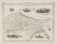
1851200119AG1851. London & New York John Tallis & Company 1851. Original steel engraving / Vintage map. Drawn and engraved by John Rapkin. Partly hand-coloured. Illustrations by A.H. Wray and Engraved by J.H. Kernot. Plate Size: 31.5 cm x 25 cm. Sheet Size: 37.2 cm x 27.2 cm. Vintage 19th century map in very good condition. Beautifully bordered map of northern India from Cambay to Chittagong and Aracan in the Bay of Bengal. The political subdivisions are colourfully included marking out independent Nepal and Bhutan. The regions of Jemer Malwa Allahabade and Assam can also be seen on the map along with the names of many towns and cities The regions rivers including the Ganges are shown and relief is depicted with hachuring. John Tallis 7 November 1817 3 June 1876 was an English cartographic publisher. His company John Tallis and Company published views maps and atlases in London from roughly 1838 to 1851. Tallis set up as a publisher with Frederick Tallis in Cripplegate in 1842; the business moved to Smithfield in 1846 and was dissolved in 1849. From 1851 to 1854 Tallis operated as John Tallis and Company. He started The illustrated news of the world and national portrait gallery of eminent personages in 1858 selling it for £1370 in 1861; it folded in 1863. Wikipedia The most important project John Tallis undertook was the 'Illustrated Atlas' from 1851. The original map we offer here was part of this exceptional Atlas and all the maps it contained are still today considered as the last reminder of an era of lavish map production. Tallis worked the project together with John Rapkin 1815-1876 and it was Rapkin's style and talent that we have to thank for when we marvel at these maps today. What makes these maps so special is the detail of engraved vignettes that surround the map and often show indigenous scenes people in their environment and even more so historical buildings or historical views of towns and cities architecture and landscape. The project of 'The Illustrated Atlas' was designed to be finished just in time for the anxiously awaited "Great Exhibition of the Works of Industry of All Nations" or The Great Exhibition sometimes referred to as the Crystal Palace Exhibition in reference to the temporary structure in which it was held was an international exhibition that took place in Hyde Park London from 1 May to 11 October 1851. It was the first in a series of World's Fairs exhibitions of culture and industry that became popular in the 19th century and it was a much anticipated event. The Great Exhibition was organized by Henry Cole and Prince Albert husband of the reigning monarch Queen Victoria. It was attended by numerous notable figures of the time including Charles Darwin Samuel Colt members of the Orléanist Royal Family and the writers Charlotte Brontë Charles Dickens Lewis Carroll George Eliot and Alfred Tennyson. Music for the opening was under the direction of Sir George Thomas Smart and the continuous music from the exhibited organs for the Queen's procession was "under the superintendence of William Sterndale Bennett". Wikipedia unknown
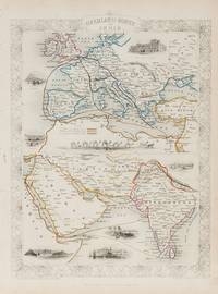
1851200124AG1851. London & New York John Tallis & Company 1851. Original steel engraving / Vintage map. Drawn and engraved by John Rapkin. Partly hand-coloured. Illustrations by H. Warren and Engraved by J. Rogers. Plate Size: 34.5 cm x 34 cm. Sheet Size: 27.2 cm x 37.4 cm. Vintage 19th century map in very good condition. Published in the Illustrated Atlas And Modern History Of The World Geographical Political Commercial & Statistical Edited By R. Montgomery Martin. Beautifully bordered and fascinating double map of the overland route between Britain and India. The upper map shows Europe and the links - both land and sea - running from England through to Alexandria Egypt. The routes are; the 'Mail Steam Packet Route' which runs around Gibraltar through Malta and onto Egypt; the 'Marseilles Overland Route' that runs across France to Marseilles and onto Alexandria via Malta and; the 'German Overland Route' that runs through across Belgium Germany before reaching Trieste and then onto the Mediterranean and then Egypt. The second map shows the differing routes on the next part of the journey - either across the Turkish controlled Middle East and through the Persian Gulf or down the Red Sea and across the Indian Ocean. What the map clearly illustrates is the importance attached to India 'Hindoostan' in the Imperial mind and the need for secure communication and transport links which necessitated control of certain choke points on the link such as Gibraltar Malta Suez etc. John Tallis 7 November 1817 3 June 1876 was an English cartographic publisher. His company John Tallis and Company published views maps and atlases in London from roughly 1838 to 1851. Tallis set up as a publisher with Frederick Tallis in Cripplegate in 1842; the business moved to Smithfield in 1846 and was dissolved in 1849. From 1851 to 1854 Tallis operated as John Tallis and Company. He started The illustrated news of the world and national portrait gallery of eminent personages in 1858 selling it for £1370 in 1861; it folded in 1863. Wikipedia The most important project John Tallis undertook was the 'Illustrated Atlas' from 1851. The original map we offer here was part of this exceptional Atlas and all the maps it contained are still today considered as the last reminder of an era of lavish map production. Tallis worked the project together with John Rapkin 1815-1876 and it was Rapkin's style and talent that we have to thank for when we marvel at these maps today. What makes these maps so special is the detail of engraved vignettes that surround the map and often show indigenous scenes people in their environment and even more so historical buildings or historical views of towns and cities architecture and landscape. The project of 'The Illustrated Atlas' was designed to be finished just in time for the anxiously awaited "Great Exhibition of the Works of Industry of All Nations" or The Great Exhibition sometimes referred to as the Crystal Palace Exhibition in reference to the temporary structure in which it was held was an international exhibition that took place in Hyde Park London from 1 May to 11 October 1851. It was the first in a series of World's Fairs exhibitions of culture and industry that became popular in the 19th century and it was a much-anticipated event. The Great Exhibition was organized by Henry Cole and Prince Albert husband of the reigning monarch Queen Victoria. It was attended by numerous notable figures of the time including Charles Darwin Samuel Colt members of the Orléanist Royal Family and the writers Charlotte Brontë Charles Dickens Lewis Carroll George Eliot and Alfred Tennyson. Music for the opening was under the direction of Sir George Thomas Smart and the continuous music from the exhibited organs for the Queen's procession was "under the superintendence of William Sterndale Bennett". Wikipedia unknown
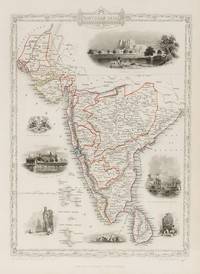
1851200109AG1851. London & New York John Tallis & Company 1851. Original steel engraving / Vintage map. Drawn and engraved by John Rapkin. Partly hand-coloured. Illustrations by A.H. Wray and Engraved by J.H. Kernot. Plate Size: 31.8 cm x 25.5 cm. Sheet Size: 37.2 cm x 27.2 cm. Vintage 19th century map in very good condition. Beautiful map of the southern Indian subcontinent from Sinde at the mouth of the Indus Estuary in the north down through Gujerat Bejapor and Mysore and down into the Carnatic region in the south. Hydrabad and Circars border the Bay of Bengal. Ceylon is also included in the map as are the Laccadive and Maldive islands in the Indian Ocean. Relief is depicting with hachuring. The major cities such as Bombay Sernigapatam and Madras are shown as are the rivers - including the Godavery and Beema rivers. This was an India dominated by the East India Company the British joint-stock company that came to rule large areas of India with its private armies exercising military power and seizing administrative functions. Formed in the early 1600s to compete with the Dutch for trade and commerce in the East the company rose to account for half of the world's trade at one point. Company rule in India lasted until 1858 when following the Indian Rebellion of 1857 the Government of India Act 1858 led to the British Crown's assuming direct control of the Indian subcontinent in the form of the new British Raj. The company was dissolved in 1874 as a result of the East India Stock Dividend Redemption Act passed one year earlier as the Government of India Act had by then rendered it vestigial powerless and obsolete. The official government machinery of British India assumed the East India Company's governmental functions and absorbed its navy and its armies in 1858. Wikipedia John Tallis 7 November 1817 3 June 1876 was an English cartographic publisher. His company John Tallis and Company published views maps and atlases in London from roughly 1838 to 1851. Tallis set up as a publisher with Frederick Tallis in Cripplegate in 1842; the business moved to Smithfield in 1846 and was dissolved in 1849. From 1851 to 1854 Tallis operated as John Tallis and Company. He started The illustrated news of the world and national portrait gallery of eminent personages in 1858 selling it for £1370 in 1861; it folded in 1863. Wikipedia The most important project John Tallis undertook was the 'Illustrated Atlas' from 1851. The original map we offer here was part of this exceptional Atlas and all the maps it contained are still today considered as the last reminder of an era of lavish map production. Tallis worked the project together with John Rapkin 1815-1876 and it was Rapkin's style and talent that we have to thank for when we marvel at these maps today. What makes these maps so special is the detail of engraved vignettes that surround the map and often show indigenous scenes people in their environment and even more so historical buildings or historical views of towns and cities architecture and landscape. The project of 'The Illustrated Atlas' was designed to be finished just in time for the anxiously awaited "Great Exhibition of the Works of Industry of All Nations" or The Great Exhibition sometimes referred to as the Crystal Palace Exhibition in reference to the temporary structure in which it was held was an international exhibition that took place in Hyde Park London from 1 May to 11 October 1851. It was the first in a series of World's Fairs exhibitions of culture and industry that became popular in the 19th century and it was a much anticipated event. The Great Exhibition was organized by Henry Cole and Prince Albert husband of the reigning monarch Queen Victoria. It was attended by numerous notable figures of the time including Charles Darwin Samuel Colt members of the Orléanist Royal Family and the writers Charlotte Brontë Charles Dickens Lewis Carroll George Eliot and Alfred Tennyson. Music for the opening was under the direction of Sir George Thomas Smart and the continuous music from the exhibited organs for the Queen's procession was "under the superintendence of William Sterndale Bennett". Wikipedia unknown
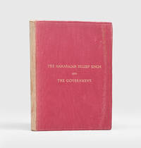
1884189408London: Printed by the Ballatyne Press "For Private Circulation" 1884. Duleep Singh reclaims his throne First and only edition privately issued of this controversial presentation of the maharajah's grievances against the British Government's claims to the Punjab. Decidedly uncommon around 14 copies traced institutionally just a couple at auction. An excellent copy of a fragile fugitive and highly desirable work here in a variant binding to the black skiver usually encountered. The child king Duleep Singh 1838-1893 Maharajah of Lahorewas carried into exile following defeat in the Second Anglo-Sikh War 1848-9 converting to Christianity in 1854 obtaining a royal audience and becoming "an immediate success" with the Queen and eventually settling in Elveden Suffolk with Bamba Müller his "part-Ethiopian part-German" ODNB wife who he had met in Cairo when returning from his mother's funeral in India; "Duleep Singh loved Elveden and rebuilt the church cottages and the school. His fame as a shooter of game was revived in the grounds of the great estate". However "amid European glamour the spirit that had tasted sovereignty was hibernating somewhere in the mind of Duleep Singh. Prompted initially by his mother then by his cousin Thakur Singh Sandhanwalia and finally by the supposed prophecies of the tenth Sikh guru Duleep Singh began a battle with the British government asserting the illegality of the annexation of the Punjab and demanded to be reinstated as maharajah. In 1886 he tried to return to India to place himself as the prophesied head of the Sikh people but was arrested at Aden. Here he was received back into the Sikh faith". From Paris he made himself the centre of various plots to overthrow British rule in the Punjab scheming with Russian and Irish revolutionaries to force the Khyber Pass but all of these conspiracies came to nothing. Increasingly dogged by ill health he sought a reconciliation with Victoria who "responded with a full pardon through the secretary of state on 1 August 1890". He died in Paris in 1893 and was carried back to his beloved Elveden and buried in the graveyard of St Andrew's and St Patrick's Church. The present work represents the historical groundwork to his campaign for reinstatement to the throne and was distributed solely to those who he felt could be of influence to that end. It was "compiled partly from historical sources and partly from private information and documents furnished" Preface by Duleep Singh himself and encompasses a sketch of the early history of the Punjab; a biographical narrative of the Maharajah; and an explanation "of the peculiar Relations in which the Maharajah stands towards the Government and the causes of the differences between them". Octavo. pp. viii 183. Original moderate red cloth over flexible boards title gilt to the front cover single fillet blind panel to both covers grey-blue decorative endpapers. Slightly rubbed the spine sunned; endpapers a little browned pale toning to the text-block else a very good copy. hardcover
181215101AB1812. 12thyear second part off 2. Leipzig Fleischer 1812. 13 : 9 cm. XVII 306 pages with engraved title-page 9 7 folded engraved plates. Contemporary boards slipcase. This volume treats extensive with India culturell economicly historical etc. The plates show landscape temples plants people etc. - Binding a bit rubbed. - Text in German. hardcover
1866MDIanIND15<p>Simla: Printed At The Simla Advertiser Press; Wallace Cotton & Co. 1866. 1866. 8vo. pp. 3 p.l. 70 1 leafads on orange paper. tipped-in notice at p. 73. contemporary half roan leather label on upper cover binding worn & rubbed label chipped lacking rear flyleaf. several contemporary ms. notes. Hardcover.</p> Simla: Printed At The Simla Advertiser Press; Wallace, Cotton, & Co., 1866. hardcover
1844INDIA014500John Murray London. 1844. New edition of a book originally published in 1828. Small octavo. Two volumes: pp viii 311 1 adverts; iv 304. Double-column text. Period binding of quarter tan calf with raised bands gilt rules green morocco title labels marbled boards.Contemporary 1845 ownership signature on each title-page. Covers rubbed at the edges. Spines rubbed and faded. A very good set. John Murray, London. hardcover
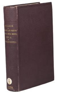
1878ABC_45484London: George E. Eyre & William Spottiswoode colophon 1878. Contemporary cloth title in gold on spine. Large 8vo. First and only edition of a catalogue of the material held in the London India Office that was produced by the Indian Surveys for the East India Company. The catalogue was printed by order of her Majesty's Secretary of State for India in council. It is a key reference work for all studies on the East India Company era in Indian and British history.Shelf mark on spine library plate on front paste-down Scheepvaartmuseum Amsterdam. Slight foxing on the first and last couple pages. Otherwise in very good condition.l Kaul Early writings on India: a union catalogue of books on India in the English language published up to 1900 and available in Delhi libraries 1975 92. George E. Eyre & William Spottiswoode (colophon), hardcover
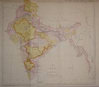
18717187London: House of Commons 1871. Lithographed colour-printed map 32 x 35 cms cut close to printed area blank verso; prepared by the India Office for their annual report: East India Progress and Condition. Statement exhibiting the moral and material progress and condition of India .; shows developing railway nework including railways proposed and under construction. Map House of Commons unknown
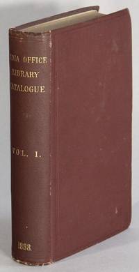
188869822London: printed by Eyre and Spottiswoode printers to the Queen's Most Excellent Majesty 1888. 8vo pp. 4 567 1; original brown cloth gilt-stamped spine; near fine. Without the separately printed Index and Supplements. This is the first in a series of catalogues that ran until 1937. It is the only catalogue of western books in the India Office. Other volumes included books in Sanskrit Hindistani Hindi Panjabi Pushtu Sindhi Bengali Oriya Assamese Marathi Gujarati and Persian languages. printed by Eyre and Spottiswoode, printers to the Queen's Most Excellent Majesty unknown
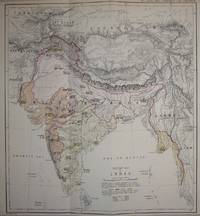
18737191London: House of Commons 1873. Lithographed colour-printed map 31 x 28 cms blank verso; prepared by the India Office for their annual report: East India Progress and Condition. Statement exhibiting the moral and material progress and condition of India .. Map House of Commons unknown
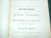
1898011601India: India 1898. 10 budget estimates of the Irrigation Branch for 1897-98. Rajputana. Baluchistan. Upper Burma. Lower Burma. Bengal. North-Western Province and Oudh. Punjab. Madras. Bombay. Bombay-Sind. Each section has a separate title page. 318pp in all. Bound in cloth backed printed boards. Spine sellotaped boards rubbed library stamp and number cancellation stamp. Although worn binding in good condition. Internally some tanning pages in good clean condition throughout. A good clean copy. Hardcover. Good Plus. Quarto. India Hardcover