Caribbean Research InstituteBiblio.com
754 résultats
0265890950.Ghardcover. Good. Access codes and supplements are not guaranteed with used items. May be an ex-library book. hardcover
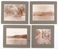
51-4293Circa 1902. Gray card mount 5x6". Photograph 3½x4¾". "Queen's Arch Port of Spain Trinidad B.V.I." written on card verso.Gray card mount 5x6". Photograph 3½x4¾". "View of St. Piere sugar mill and plantation to the right of the City of St. Piere. Martinique B.V.I." written on the card verso.Gray card mount 5x5". Photograph 3½x3". "Alabama anchorage" written on the front of the card mount and "The city of St. Piere and Harbor with Mt. Pelee to the left." written on card verso.Gray card mount 5x6". Photograph 3¼x3". "Alabama crew catching a shark in Culebra Harbor Virgin Islands. Jan 27th 1902." writ Circa 1902 unknown
1851200111AG1851. London & New York J & F. Tallis 1851. Original steel engraving / Vintage map. Drawn and engraved by John Rapkin. Partly hand-coloured. Illustrations by H. Warren and Engraved by J. Rogers. Plate Size: 25 cm x 35 cm. Sheet Size: 27 cm x 37.4 cm. Vintage 19th century map in very good condition. A beautiful map of the West Indies: from the Bahamas in the North near the southern tip of Florida down to Barbados and Trinidad of the coast of Colombia. Cuba Jamaica Hispaniola San Domingo and Haiti Porto Rico the Virgin Islands and the myriad of smaller islands throughout the Caribbean Sea are also included. The Mosquito Coast in modern Nicaragua Guatemala and the Panama isthmus can also be seen. Relief depicted with hachuring. The major towns and cities across this region such as Havana Kingston and Port Royal Port Republican Port-au-Prince and Cartagena are also shown. A depiction of native peasants and a medallion complete this pleasant map. John Tallis 7 November 1817 3 June 1876 was an English cartographic publisher. His company John Tallis and Company published views maps and atlases in London from roughly 1838 to 1851. Tallis set up as a publisher with Frederick Tallis in Cripplegate in 1842; the business moved to Smithfield in 1846 and was dissolved in 1849. From 1851 to 1854 Tallis operated as John Tallis and Company. He started The illustrated news of the world and national portrait gallery of eminent personages in 1858 selling it for £1370 in 1861; it folded in 1863. Wikipedia The most important project John Tallis undertook was the 'Illustrated Atlas' from 1851. The original map we offer here was part of this exceptional Atlas and all the maps it contained are still today considered as the last reminder of an era of lavish map production. Tallis worked the project together with John Rapkin 1815-1876 and it was Rapkin's style and talent that we have to thank for when we marvel at these maps today. What makes these maps so special is the detail of engraved vignettes that surround the map and often show indigenous scenes people in their environment and even more so historical buildings or historical views of towns and cities architecture and landscape. The project of 'The Illustrated Atlas' was designed to be finished just in time for the anxiously awaited "Great Exhibition of the Works of Industry of All Nations" or The Great Exhibition sometimes referred to as the Crystal Palace Exhibition in reference to the temporary structure in which it was held was an international exhibition that took place in Hyde Park London from 1 May to 11 October 1851. It was the first in a series of World's Fairs exhibitions of culture and industry that became popular in the 19th century and it was a much anticipated event. The Great Exhibition was organized by Henry Cole and Prince Albert husband of the reigning monarch Queen Victoria. It was attended by numerous notable figures of the time including Charles Darwin Samuel Colt members of the Orléanist Royal Family and the writers Charlotte Brontë Charles Dickens Lewis Carroll George Eliot and Alfred Tennyson. Music for the opening was under the direction of Sir George Thomas Smart and the continuous music from the exhibited organs for the Queen's procession was "under the superintendence of William Sterndale Bennett". Wikipedia unknown
19484800Washington: Kaufman Press 1948. Paperback. Very Good. folding map xix 259p. Original wrapper. External Trade Bulletin No. 3. <br/><br/> Kaufman Press paperback books
197324847Bridgetown Barbados: CADEC 1973. Second Edition. Quarto 27.5cm.; original white pictorial staplebound wrappers printed in green and black; 59pp.; illus. Mild dust soiling else Fine. Guide and objectives of the Consultation as formed by the Caribbean Conference of Churches. Originally published as a report of the first Consultation held in 1971. CADEC unknown books
1860WRCAM48522Antigua but actually Philadelphia: R.B. Eldridge & Co. 1860. Lithographic sheet map 20 1/2 x 26 1/2 inches. Backed with contemporary blue paper. Light foxing and toning. A few small tears in margins. Very good. An unusual lithographic edition of Norie's 1827 revision of this handsome chart lithographed by Wagner & McGuigan in Philadelphia. A statement in the cartouche reads: "Presented by R.B. Eldridge Antigua to Captain Andrew Tyler." The captain's name is accomplished in manuscript. R.B. Eldridge is not listed in Tooley's DICTIONARY OF MAPMAKERS and appears to be unrelated to publisher of charts George Eldridge. It seems most likely that he was rather an Antigua merchant who commissioned a reprint of the chart for complimentary distribution to sea captains. A handsome piece. R.B. Eldridge & Co. unknown books
19464801Washington: Caribbean Commission 1946. Paperback. Good. folding map index xi 148p. Original wrapper. Minor damping. Crop Inquiry Series No. 1. <br/><br/> Caribbean Commission paperback books
186246424Concord MA 1862. First Separate Edition. Octavo 24cm.; side-stitched self-wrappers; 15pp.; text printed in double columns. Wrappers separated and rather ragged along extremities the whole dust-soiled; Good only. Originally delivered as a lecture before being published in the abolitionist newspaper "The Pine and Palm" also known as the "Weekly Anglo-African". Sanborn a member of the "Secret Six" who provided funding to John Brown in the 1850s describes the effects of the emancipation of slaves in the West Indies noting that no violence broke out nor did it lead to an economic depression as had been predicted by Confederate propaganda. See "A Guide to the Study of British Caribbean History 1763-1834" 1932 p. 548; LCP AFRO-AMERICANA 9085; SABIN 76248. unknown books
197323404London: Caribbean Situationist July 1973. First edition thus. Wraps. Very good. Poster folded into quarters 36" x 23" approx. unfolded. Verso lightly toned; moderate wear to edges and fold lines. Creasing to corners. Very good. <br/><br/>Poster reproducing translated text by Khayati originally published in Internationale Situationniste and subsequently as a brochure in 1971 Ford 167. Illustrated with black and white photographs of Kingston Jamaica; Trinidad; and Hungary. Lower right corner includes a blank space intended to advertise a record shop where an LP of the text apparently spurious would be available. Uncommon. OCLC odes not locate a copy though there does appear to be on at Michigan. Caribbean Situationist paperback books
First edition, [2], 78, [2]pp., slight foxing of first few leaves, folding table, disbound. In reply to "An Address to the Members of the New Parliament, on the proceedings of the Colonial Department.....", which held that if slaves were freed they would not work, and as a consequence the colonialist's properties would fall into decay through lack of labourers. This pamphlet denies that the proceedings of the Colonial Department on the matter of Caribbean slavery had been injudicious and unauthorised. Ragatz, p.451; Sabin, 69410.
5300CARIBBEAN TRAVEL JOURNAL. Diary. 101 pages. The Caribbean. c. 1908-9. The handwritten journal belonging to C. B. Benson of Hudson New York. The diary recounts Benson’s experience on an organized cruise group visit to Caribbean locations such as St. Thomas Puerto Rico Kingston Jamaica Caracas Venezuela Panama City Panama Port of Spain Trinidad and Martinique. Benson records his experiences in each location including his impressions of the town the locals sights he visited and local travel. He visited forts a school churches a mill a sugar plantation and Carnival celebrations. Benson took his tour during the era of colonial rule the attitudes of which infuse both his experiences and observations. Based on his mention of an earthquake in Kingston Jamaica taking place a year or two before he travelled in 1908 or 1909. “…St. Thomas where we arrived about 6 A.M. mid morning Jan 26 is one of the Virgin group and we found her framed and frescoed in the principal churches. Columbus in 1493 gave the group of 100 islands rocks and…which comprise the group. St. Thomas is 13 miles in length and 3 miles in width at its broadest. And I guess we walked the length of it speaking broadly and in the abstract at this distance.The heat of the tropical sun also takes its toll and blurs our ideas of time and distance somewhat. The town of Charlotte Amelia contains 13000 inhabitants – merchants and black babies and they are all dressed in their Sunday best to receive us properly.Thursday morning at 8 we went ashore at Porto sic Rico.Returning thro the village streets we stopped at the market place and noticed the display of fruits in baskets a couple of men seated on low stools with blacks in front of them.a native woman…was entertaining us in the middle of the road with a dance.When passing the island of Haiti.‘Do you know why we do not stop at the Island of Haiti’ ‘No’ There are cannibals there there are so many fat people aboard you would lose your wife’ At St Thomas the American council held open house and received some of us who dared to invade this solitude.An hour’s railroad ride which was made interesting by stops at every little…and station where the bare legged boy with the oil gun in hand squirted oil…bearings sic of the cars and engine. As it was before the 17 miles came to an end the rear axle of the parlor car so called because it had leather covered reclining seats caught fire. But when this happened we were nearly at the end of our journey and we were not delayed much. At the sugar plantation where we detrained we found we had some distance to walk down…to the sugar mill. As there was no path and the sticky wet ground to soil made worse by the heavy rain of the night before.A sugar mill is never a clean place.The process is somewhat intricate but way he likened to the process of brewing.The cane piled up in the yard is boiled in a number of vats then is run off with barrels and in a black and solid state in shipped to the Refineries at New York. The fiber of the cane is then hardened and dried and is fed to the furnaces to boil…cane. After return to the town San Juan we visited the shops. Walked out to the fort at the entrance of the harbor. The town is excellently policed and paved in the principal streets with telegram blocks.As this day was Thursday we concluded that every day was wash day for the native women and girls who for want of other diversions spend most of their time in this form of dissipation. Even the balconies of the main public street filled with traffic of street cars carriages and drays had their fill of wash some of which are found laying in the street having been carried down by the wind. No one had appropriated it as yet; and we did not add it to our collection of souvenirs. At the officers quarters I applied for a permit of the officer of the day to enter the fort ‘San Cristobal’ the fort commanding the entrance to the harbor.The fort was like most forts. The high tower gave a commanding view of the town and harbor. Then we visited the Governor’s Palace. In the Reception Room hanging on opposite sides facing each other are life sized oil paintings of McKinley & Cleveland. In the garden were some large palms tropical ferns a fountain &.Jan 29. early in the morning we were at Kingston in Jamaica. The channel is narrow and tortuous but well… Taking a local pilot we soon…opposite it…of three vessels one of which was the Princess Louise that was caught in the hurricane here three years ago and…the larger of the three vessels was trying to pick up the light from the light house which had been blown down. This destruction of the hurricane.After driving about a mile thru the city the destruction to the buildings & pavements made by the earthquake here a year or two ago half of the city seems to be in ruins and no attempt has been made apparently to rebuild & restore the city. Thousands of lives were lost here at that time which did immense damage to the fruits. Most of the uninhabitable part of the island belongs to the United Fruit Company a Boston Corporation who ships immense quantities of bananas from Port Antonio. Owing to recent destruction by fire of Hotel Litchfield our stop at the port of San Antonio and stay of night at the Hotel was omitted. An excursion across the island by train to Mandeville was arranged in its place.The town of Colon in its principle streets are paved with brick and appear clean. We noticed many buzzards. The air was clear and there was a delightful cool breeze blowing.We stopped at all of the stations going to Panama and noted the wonderful impressions made by the Sanitary Commission. The well ventilated and screened houses. The plan for disposal of garbage the open drainage the cleared lands…But of course the facts are here – bug and drain – all working to the mutual exclusion of some ideas to the American white employers. Therefore after a few months they must have a reaction in the States to…and detach themselves from all absorbing facts. The fighting for life against…fires. Most things are…between the white employers and the black employees. So we find the ‘White Bar’ and the ‘Black Bar’ ‘The White Employees’ ‘The Silver White Employees’ &c as signs on the cars intended to carry workmen back and forth from the works.Caracas the capital of Venezuela is about 3000 ft up but the sun in the middle of the day we found very hot.Plaza Bolivar was decorated with rows of colored electric lights. They are preparing for the Carnival season which ushers in Lent in Catholic countries. The market place had counters for dry goods highly colored handkerchiefs etc. Another section was devoted to fruits vegetables etc. We noticed some very large apricots. Mr. Bolivar apparently has done a great deal for his native town. He has given his name – while the people furnished the funds – for the largest parks a street and the coinage of the plutocrats.The Spaniard the…Hildago -in his easy subjugation of the…pleasure loving tropical savage has replaced the native of simple taste and left in his place the mongrel half-breed with all the vices of the conqueror and none of the virtues of the…Indian savage…â€. The diary is in very good condition. It is mostly written in pencil but is quite legible. hardcover books
9211212650.Gpaperback. Good. Access codes and supplements are not guaranteed with used items. May be an ex-library book. paperback
1528327918.Gpaperback. Good. Access codes and supplements are not guaranteed with used items. May be an ex-library book. paperback
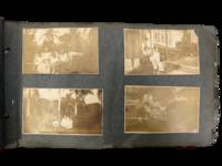
1914231551914. Caribbean photograph album likely compiled by a person connected to the Panama Canal Zone and the Caribbean documenting how steamship mobility port circulation and U.S. imperial presence linked Jamaica Venezuela Trinidad Barbados Cuba Puerto Rico the Bahamas Florida and Panama in the years after the canal opened. The felt cover lettered "PANAMA" and bearing the Seal of the Canal Zone places the album within the new travel geography created by U.S. control of the Canal Zone and the canal's 1914 opening when Panama became a central hinge between Atlantic and Pacific movement and a major point of contact between North American travelers and Caribbean port cities. Photos show passengers on steamers and docks markets and streets forts and government buildings and repeated encounters between white visitors and Afro Caribbean and mixed-heritage residents across multiple colonial and semi-colonial settings.<br /> <br /> Panama Canal Zone travel photograph album. Caribbean and circum-Caribbean locations including Kingston Jamaica; La Guaira and Caracas Venezuela; Trinidad; Key West and Palm Beach Florida; Havana Cuba; Barbados; Panama City Balboa and Colón Panama; Nassau Bahamas; and San Juan Puerto Rico. Likely circa mid 1910s to early 1920s. Oblong felt-covered album measuring 6.5" x 11" with "PANAMA" stitched in large letters on the front cover and photographs pasted to grey leaves. Contains more than 160 black-and-white photographs most approximately 2.5 x 4.5 inches many with handwritten captions identifying locations activities and occasional names. The sequence opens in Kingston with captions including "Kingston JA" and "on the steamer" then moves through island and mainland stops; "Port of Spain Trinidad" "Market at Barbados" "Rapid Transit Barbados" "Havana Cuba" "San Juan Porto Rico" "Morro Castle" "Balboa" and "Colon R.P." Repeated figures especially a young college-aged woman and an older woman appear throughout. Notable images include a group of locals in shallow water at Barbados sifting for tossed coins from rowboats; a large crowd scene in San Juan gathered for what appears to be a public speech or civic event; battlements cannon and stone defenses in Havana; vernacular dwellings and children in impoverished conditions in Balboa; posed visitor photographs in what is labeled a "bull ring"; and numerous street dockside market and architectural views that juxtapose local populations with hotels public buildings ruins and newer urban construction.<br /> <br /> The album's historical force comes from the way it captures the social landscape of Caribbean travel under early twentieth-century U.S. power. After 1914 the Canal Zone intensified Panama's role within a wider American maritime sphere while Caribbean travel increasingly moved through port infrastructures shaped by empire commerce military strategy and tourism; this album records that world at eye level with photographs of docks steamers fortifications government sites public squares and local street life rather than limiting themselves to family snapshots alone. At the same time the images preserve the unequal human encounters built into that system especially where visitors photograph Black children boatmen market crowds and working neighborhoods as part of the travel experience. Felt cover worn and soiled with losses at edges and stitching strain; leaves brittle with chipping and tears; photographs generally present and legible with silvering fading corner wear and occasional losses or lifting. Overall fair to good condition. A substantial early twentieth-century visual record of Canal Zone connected Caribbean travel with dense captioning and wide geographic reach from Jamaica and Barbados to Havana San Juan and Panama. unknown
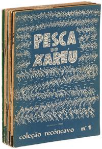
1955593625Bahia Brasil: Livraria Progresso 1955. Softcover. Very Good. First editions. Illustrated by Caribé. Nine volumes lacking the 10th Orixás. Slim octavos. Stapled wrappers. Text in Portuguese. Moderate tanning and wear wrappers with some foxing and soiling topedges with a small splash of white paint sound and near very good. Each volume prints illustrations by Caribé from the Bahia State Museum as well as text by Caribé Odorico Tavares Vasconcelos Main José Pedreira or Carlos Eduardo. Each also has a number stamp on the copyright page from an unknown limitation. The titles are: A pesca do xaréu; Pelourinho; O jogo da capoeira; Feira de água de meninos; Festa do bonfim; Conceicão da praia; Festa de yemanjá; Rampa do mercado; and Temas de candomblé. Livraria Progresso unknown
3639697065.Gpaperback. Good. Access codes and supplements are not guaranteed with used items. May be an ex-library book. paperback
9788532658654VOZES. new. Description anavailable VOZES unknown
241 p., illus. Hardcover Good condition; cloth boards faded
1933biblio313Universidad Nacional de Tucuman. With autograph dedication from the author. 708 pp. Cover and spine have wear on edges. Binding is quite original interior in immaculate condition. A. Baiocco & Cia paperback
Madrid, 1954 ["Cuadernos de Historia de las Relaciones Internacionales y Política Exterior de España"]. 4to.; 84 pp. Cubiertas originales.
38546317-75Ediciones B. Used - Very Good. Former library copy. Pages intact with possible writing/highlighting. Binding strong with minor wear. Dust jackets/supplements may not be included. Includes library markings. Stock photo provided. Product includes identifying sticker. Better World Books: Buy Books. Do Good. Ediciones B unknown
México, 1937. 4to.; 16 hojas sin paginar. Ejemplar corto de márgenes inferiores con pérdida de algunas letras en una hoja. Cubiertas mudas en cartulina.
2008500074105BUCHET CHASTEL 2008 444 pages 20 2x3x13 4cm. 2008. Broché. 444 pages.