Caribbean Examinations CouncilBiblio.com

248 résultats
1408517027.Gpaperback. Good. Access codes and supplements are not guaranteed with used items. May be an ex-library book. paperback
DADAX1408517027OXFORD UNIVERSITY PRESS 2014-11-01. Revised ed. paperback. New. 7.69x0.36x10.50. Buy with confidence. Excellent Customer Service & Return policy. OXFORD UNIVERSITY PRESS paperback
1408520982.Gbundle. Good. Access codes and supplements are not guaranteed with used items. May be an ex-library book. unknown
1408520958.Gbundle. Good. Access codes and supplements are not guaranteed with used items. May be an ex-library book. unknown
1408516659.Gbundle. Good. Access codes and supplements are not guaranteed with used items. May be an ex-library book. unknown
1408517612New. Brand new and still unused unknown
1408517647.Gpaperback. Good. Access codes and supplements are not guaranteed with used items. May be an ex-library book. paperback
1408517612.Gpaperback. Good. Access codes and supplements are not guaranteed with used items. May be an ex-library book. paperback
1408522454.Gbundle. Good. Access codes and supplements are not guaranteed with used items. May be an ex-library book. unknown
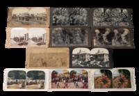
1890231711890. Stereoview archive of the post-emancipation Caribbean showing how the islands were marketed to western viewers through plantation labor export agriculture civic spectacle and catastrophe. As a group these photos function not only as an ethnographic travel archive but as evidence of the visual economy that followed slavery. The British West Indies moved through emancipation in 1834 to 1838 the French Caribbean in 1848 Puerto Rico in 1873 and Cuba in 1886 yet plantation production remained central to regional life well into the early twentieth century. These stereoviews preserve a colonial way of seeing in which Black and Afro-Caribbean labor rural discipline and extractive agriculture remained the background condition of "tropical" beauty and commercial modernity. Cuba's sugar economy in particular expanded through the nineteenth century and slavery was not abolished there until 1886 while Weyler's later reconcentration policy during the Cuban War of Independence violently reorganized rural life. Martinique after 1848 likewise shifted into new labor regimes including imported workers from India and China.<br /> <br /> Archive of 11 stereoview cards late 1890s to early 1900s depicting Cuba Jamaica Martinique Puerto Rico and the Dominican Republic. Most black and white with a few colorized. Each measure 3.5" x 7". All with captions on the margins. "Reconcentrado Farming Scene Province of Havana Cuba" links agricultural production to the brutal displacements of Spain's reconcentration campaign; "Cutting sugar cane Montego Bay Jamaica W.I." records cane labor in a colony where emancipation had not ended plantation dependency; and "Harvesting Coconuts Porto Rico" likewise frames Caribbean land through export work rather than local life. Other views extend that economic framing through cacao and coffee scenes while the paired Havana cards shift into urban leisure and public display including "Beautiful Central Park Havana Cuba" and "Holiday in Havana Cuba" the latter with both Cuban and American flags visible a telling image of the new imperial order after 1898. The disaster views from Martinique and the Lesser Antilles show how stereoview publishers also turned Caribbean destruction into consumable spectacle. the Morne Rouge card is accompanied on the reverse by the grim printed text "Dead bodies which were to be seen in Morne Rouge." while the wider context is the 1902 eruptions of Mount Pelée in Martinique and La Soufrière on Saint Vincent two catastrophes that killed roughly 30000 and 1600 people respectively and devastated local communities and agriculture.<br /> <br /> Some corner wear light toning scattered surface and edge wear. Overall very good condition. This collection gives direct visual representation of Caribbean history Atlantic slavery and emancipation plantation labor and U.S. imperial expansion in the circum-Caribbean preserving the transition from slavery to post-abolition labor. unknown
1408520397.Gbundle. Good. Access codes and supplements are not guaranteed with used items. May be an ex-library book. unknown
1408516349.Gbundle. Good. Access codes and supplements are not guaranteed with used items. May be an ex-library book. unknown
33966London: John Murray Albemarle Street 1826. First edition 2 78 2pp. slight foxing of first few leaves folding table disbound. In reply to "An Address to the Members of the New Parliament on the proceedings of the Colonial Department." which held that if slaves were freed they would not work and as a consequence the colonialist's properties would fall into decay through lack of labourers. This pamphlet denies that the proceedings of the Colonial Department on the matter of Caribbean slavery had been injudicious and unauthorised. Ragatz p.451; Sabin 69410. London: John Murray, Albemarle Street, 1826 unknown
1408519933.Gbundle. Good. Access codes and supplements are not guaranteed with used items. May be an ex-library book. unknown
0265890950.Ghardcover. Good. Access codes and supplements are not guaranteed with used items. May be an ex-library book. hardcover
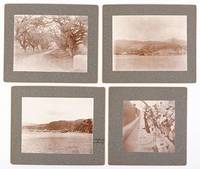
51-4293Circa 1902. Gray card mount 5x6". Photograph 3½x4¾". "Queen's Arch Port of Spain Trinidad B.V.I." written on card verso.Gray card mount 5x6". Photograph 3½x4¾". "View of St. Piere sugar mill and plantation to the right of the City of St. Piere. Martinique B.V.I." written on the card verso.Gray card mount 5x5". Photograph 3½x3". "Alabama anchorage" written on the front of the card mount and "The city of St. Piere and Harbor with Mt. Pelee to the left." written on card verso.Gray card mount 5x6". Photograph 3¼x3". "Alabama crew catching a shark in Culebra Harbor Virgin Islands. Jan 27th 1902." writ Circa 1902 unknown
1851200111AG1851. London & New York J & F. Tallis 1851. Original steel engraving / Vintage map. Drawn and engraved by John Rapkin. Partly hand-coloured. Illustrations by H. Warren and Engraved by J. Rogers. Plate Size: 25 cm x 35 cm. Sheet Size: 27 cm x 37.4 cm. Vintage 19th century map in very good condition. A beautiful map of the West Indies: from the Bahamas in the North near the southern tip of Florida down to Barbados and Trinidad of the coast of Colombia. Cuba Jamaica Hispaniola San Domingo and Haiti Porto Rico the Virgin Islands and the myriad of smaller islands throughout the Caribbean Sea are also included. The Mosquito Coast in modern Nicaragua Guatemala and the Panama isthmus can also be seen. Relief depicted with hachuring. The major towns and cities across this region such as Havana Kingston and Port Royal Port Republican Port-au-Prince and Cartagena are also shown. A depiction of native peasants and a medallion complete this pleasant map. John Tallis 7 November 1817 3 June 1876 was an English cartographic publisher. His company John Tallis and Company published views maps and atlases in London from roughly 1838 to 1851. Tallis set up as a publisher with Frederick Tallis in Cripplegate in 1842; the business moved to Smithfield in 1846 and was dissolved in 1849. From 1851 to 1854 Tallis operated as John Tallis and Company. He started The illustrated news of the world and national portrait gallery of eminent personages in 1858 selling it for £1370 in 1861; it folded in 1863. Wikipedia The most important project John Tallis undertook was the 'Illustrated Atlas' from 1851. The original map we offer here was part of this exceptional Atlas and all the maps it contained are still today considered as the last reminder of an era of lavish map production. Tallis worked the project together with John Rapkin 1815-1876 and it was Rapkin's style and talent that we have to thank for when we marvel at these maps today. What makes these maps so special is the detail of engraved vignettes that surround the map and often show indigenous scenes people in their environment and even more so historical buildings or historical views of towns and cities architecture and landscape. The project of 'The Illustrated Atlas' was designed to be finished just in time for the anxiously awaited "Great Exhibition of the Works of Industry of All Nations" or The Great Exhibition sometimes referred to as the Crystal Palace Exhibition in reference to the temporary structure in which it was held was an international exhibition that took place in Hyde Park London from 1 May to 11 October 1851. It was the first in a series of World's Fairs exhibitions of culture and industry that became popular in the 19th century and it was a much anticipated event. The Great Exhibition was organized by Henry Cole and Prince Albert husband of the reigning monarch Queen Victoria. It was attended by numerous notable figures of the time including Charles Darwin Samuel Colt members of the Orléanist Royal Family and the writers Charlotte Brontë Charles Dickens Lewis Carroll George Eliot and Alfred Tennyson. Music for the opening was under the direction of Sir George Thomas Smart and the continuous music from the exhibited organs for the Queen's procession was "under the superintendence of William Sterndale Bennett". Wikipedia unknown
9211212650.Gpaperback. Good. Access codes and supplements are not guaranteed with used items. May be an ex-library book. paperback
1528327918.Gpaperback. Good. Access codes and supplements are not guaranteed with used items. May be an ex-library book. paperback
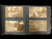
1914231551914. Caribbean photograph album likely compiled by a person connected to the Panama Canal Zone and the Caribbean documenting how steamship mobility port circulation and U.S. imperial presence linked Jamaica Venezuela Trinidad Barbados Cuba Puerto Rico the Bahamas Florida and Panama in the years after the canal opened. The felt cover lettered "PANAMA" and bearing the Seal of the Canal Zone places the album within the new travel geography created by U.S. control of the Canal Zone and the canal's 1914 opening when Panama became a central hinge between Atlantic and Pacific movement and a major point of contact between North American travelers and Caribbean port cities. Photos show passengers on steamers and docks markets and streets forts and government buildings and repeated encounters between white visitors and Afro Caribbean and mixed-heritage residents across multiple colonial and semi-colonial settings.<br /> <br /> Panama Canal Zone travel photograph album. Caribbean and circum-Caribbean locations including Kingston Jamaica; La Guaira and Caracas Venezuela; Trinidad; Key West and Palm Beach Florida; Havana Cuba; Barbados; Panama City Balboa and Colón Panama; Nassau Bahamas; and San Juan Puerto Rico. Likely circa mid 1910s to early 1920s. Oblong felt-covered album measuring 6.5" x 11" with "PANAMA" stitched in large letters on the front cover and photographs pasted to grey leaves. Contains more than 160 black-and-white photographs most approximately 2.5 x 4.5 inches many with handwritten captions identifying locations activities and occasional names. The sequence opens in Kingston with captions including "Kingston JA" and "on the steamer" then moves through island and mainland stops; "Port of Spain Trinidad" "Market at Barbados" "Rapid Transit Barbados" "Havana Cuba" "San Juan Porto Rico" "Morro Castle" "Balboa" and "Colon R.P." Repeated figures especially a young college-aged woman and an older woman appear throughout. Notable images include a group of locals in shallow water at Barbados sifting for tossed coins from rowboats; a large crowd scene in San Juan gathered for what appears to be a public speech or civic event; battlements cannon and stone defenses in Havana; vernacular dwellings and children in impoverished conditions in Balboa; posed visitor photographs in what is labeled a "bull ring"; and numerous street dockside market and architectural views that juxtapose local populations with hotels public buildings ruins and newer urban construction.<br /> <br /> The album's historical force comes from the way it captures the social landscape of Caribbean travel under early twentieth-century U.S. power. After 1914 the Canal Zone intensified Panama's role within a wider American maritime sphere while Caribbean travel increasingly moved through port infrastructures shaped by empire commerce military strategy and tourism; this album records that world at eye level with photographs of docks steamers fortifications government sites public squares and local street life rather than limiting themselves to family snapshots alone. At the same time the images preserve the unequal human encounters built into that system especially where visitors photograph Black children boatmen market crowds and working neighborhoods as part of the travel experience. Felt cover worn and soiled with losses at edges and stitching strain; leaves brittle with chipping and tears; photographs generally present and legible with silvering fading corner wear and occasional losses or lifting. Overall fair to good condition. A substantial early twentieth-century visual record of Canal Zone connected Caribbean travel with dense captioning and wide geographic reach from Jamaica and Barbados to Havana San Juan and Panama. unknown
1955593625Bahia Brasil: Livraria Progresso 1955. Softcover. Very Good. First editions. Illustrated by Caribé. Nine volumes lacking the 10th Orixás. Slim octavos. Stapled wrappers. Text in Portuguese. Moderate tanning and wear wrappers with some foxing and soiling topedges with a small splash of white paint sound and near very good. Each volume prints illustrations by Caribé from the Bahia State Museum as well as text by Caribé Odorico Tavares Vasconcelos Main José Pedreira or Carlos Eduardo. Each also has a number stamp on the copyright page from an unknown limitation. The titles are: A pesca do xaréu; Pelourinho; O jogo da capoeira; Feira de água de meninos; Festa do bonfim; Conceicão da praia; Festa de yemanjá; Rampa do mercado; and Temas de candomblé. Livraria Progresso unknown
3639697065.Gpaperback. Good. Access codes and supplements are not guaranteed with used items. May be an ex-library book. paperback
9788532658654VOZES. new. Description anavailable VOZES unknown