248 résultats
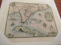
1821200023AG1821. Paris Brué 1821. Original engraving. Plate Size: 50.5 cm x 36.1 cm. Sheet Size: 68 cm x 54.1 cm. Original map. Very good condition. Extra wide margins. Some minor foxing along sheet edges. Discreet author's blind stamp with 'Carte Encyprotipe' and initials 'AB' embossed in top corner of map. Centre-fold as issued. Border with longitudinal and latitudinal information. Detailed early map of the Caribbean from an early edition of Brue's Atlas Universel Pl.35. Rich detail in Florida the Gulf Coast Central America. The eye is drawn to Cuba among the islands of the 'Grandes' and 'Petites' Antilles. As demonstrated by the map's political divisions and colourings Mexico has yet cede control of what will become Texas. Nouva Espagne and Nouv Grenade show that the aged and tottering Spanish empire has still to fall in Central and South America. The division of Hispaniola into its Haitian and Dominican parts is also shown. The great port cities of the infant United States - Charlestown Savannah and New Orleans - can be seen along the seaboard. Bermuda is shown breaching the map's top border. Reference keys and explanatory annotations and four scale-bars in lower left corner of map. Decorative title in top right corner of map. Adrien-Hubert Brué 1786 - 1832 was a renowned French cartographer. Between 1810 and 1830 Brué established himself as one of the most important French cartographers and it was during this period that his two most important works were published: Grand Atlas Universel in 1815 and Atlas Universel in 1822 which ran to several editions. Atlas Universel was published as a continuation to Grand Atlas Universel. Brués maps or cards as they were referred to at the time were characterized by the high degree of accuracy with which they were produced and the meticulous attention to detail employed in their crafting. This was possible due to Brués application of copper plate intaglio to the process of mapmaking or as Nouvelles Annales des Voyages et des Sciences Géographiques had it: by applying to the making of cards this ingenious process of drawing on copper itself. Alexandre von Humboldt the President of the Société de géographie de Paris praised the accuracy of his work and clarity that is all the more pleasing to the eye. He also was quick to update his maps with the latest scientific discoveries and nautical measurements. Wikipedia unknown
5300CARIBBEAN TRAVEL JOURNAL. Diary. 101 pages. The Caribbean. c. 1908-9. The handwritten journal belonging to C. B. Benson of Hudson New York. The diary recounts Bensons experience on an organized cruise group visit to Caribbean locations such as St. Thomas Puerto Rico Kingston Jamaica Caracas Venezuela Panama City Panama Port of Spain Trinidad and Martinique. Benson records his experiences in each location including his impressions of the town the locals sights he visited and local travel. He visited forts a school churches a mill a sugar plantation and Carnival celebrations. Benson took his tour during the era of colonial rule the attitudes of which infuse both his experiences and observations. Based on his mention of an earthquake in Kingston Jamaica taking place a year or two before he travelled in 1908 or 1909. St. Thomas where we arrived about 6 A.M. mid morning Jan 26 is one of the Virgin group and we found her framed and frescoed in the principal churches. Columbus in 1493 gave the group of 100 islands rocks andwhich comprise the group. St. Thomas is 13 miles in length and 3 miles in width at its broadest. And I guess we walked the length of it speaking broadly and in the abstract at this distance.The heat of the tropical sun also takes its toll and blurs our ideas of time and distance somewhat. The town of Charlotte Amelia contains 13000 inhabitants merchants and black babies and they are all dressed in their Sunday best to receive us properly.Thursday morning at 8 we went ashore at Porto sic Rico.Returning thro the village streets we stopped at the market place and noticed the display of fruits in baskets a couple of men seated on low stools with blacks in front of them.a native womanwas entertaining us in the middle of the road with a dance.When passing the island of Haiti.Do you know why we do not stop at the Island of Haiti No There are cannibals there there are so many fat people aboard you would lose your wife At St Thomas the American council held open house and received some of us who dared to invade this solitude.An hours railroad ride which was made interesting by stops at every littleand station where the bare legged boy with the oil gun in hand squirted oilbearings sic of the cars and engine. As it was before the 17 miles came to an end the rear axle of the parlor car so called because it had leather covered reclining seats caught fire. But when this happened we were nearly at the end of our journey and we were not delayed much. At the sugar plantation where we detrained we found we had some distance to walk downto the sugar mill. As there was no path and the sticky wet ground to soil made worse by the heavy rain of the night before.A sugar mill is never a clean place.The process is somewhat intricate but way he likened to the process of brewing.The cane piled up in the yard is boiled in a number of vats then is run off with barrels and in a black and solid state in shipped to the Refineries at New York. The fiber of the cane is then hardened and dried and is fed to the furnaces to boilcane. After return to the town San Juan we visited the shops. Walked out to the fort at the entrance of the harbor. The town is excellently policed and paved in the principal streets with telegram blocks.As this day was Thursday we concluded that every day was wash day for the native women and girls who for want of other diversions spend most of their time in this form of dissipation. Even the balconies of the main public street filled with traffic of street cars carriages and drays had their fill of wash some of which are found laying in the street having been carried down by the wind. No one had appropriated it as yet; and we did not add it to our collection of souvenirs. At the officers quarters I applied for a permit of the officer of the day to enter the fort San Cristobal the fort commanding the entrance to the harbor.The fort was like most forts. The high tower gave a commanding view of the town and harbor. Then we visited the Governors Palace. In the Reception Room hanging on opposite sides facing each other are life sized oil paintings of McKinley & Cleveland. In the garden were some large palms tropical ferns a fountain &.Jan 29. early in the morning we were at Kingston in Jamaica. The channel is narrow and tortuous but well Taking a local pilot we soonopposite itof three vessels one of which was the Princess Louise that was caught in the hurricane here three years ago andthe larger of the three vessels was trying to pick up the light from the light house which had been blown down. This destruction of the hurricane.After driving about a mile thru the city the destruction to the buildings & pavements made by the earthquake here a year or two ago half of the city seems to be in ruins and no attempt has been made apparently to rebuild & restore the city. Thousands of lives were lost here at that time which did immense damage to the fruits. Most of the uninhabitable part of the island belongs to the United Fruit Company a Boston Corporation who ships immense quantities of bananas from Port Antonio. Owing to recent destruction by fire of Hotel Litchfield our stop at the port of San Antonio and stay of night at the Hotel was omitted. An excursion across the island by train to Mandeville was arranged in its place.The town of Colon in its principle streets are paved with brick and appear clean. We noticed many buzzards. The air was clear and there was a delightful cool breeze blowing.We stopped at all of the stations going to Panama and noted the wonderful impressions made by the Sanitary Commission. The well ventilated and screened houses. The plan for disposal of garbage the open drainage the cleared landsBut of course the facts are here bug and drain all working to the mutual exclusion of some ideas to the American white employers. Therefore after a few months they must have a reaction in the States toand detach themselves from all absorbing facts. The fighting for life againstfires. Most things arebetween the white employers and the black employees. So we find the White Bar and the Black Bar The White Employees The Silver White Employees &c as signs on the cars intended to carry workmen back and forth from the works.Caracas the capital of Venezuela is about 3000 ft up but the sun in the middle of the day we found very hot.Plaza Bolivar was decorated with rows of colored electric lights. They are preparing for the Carnival season which ushers in Lent in Catholic countries. The market place had counters for dry goods highly colored handkerchiefs etc. Another section was devoted to fruits vegetables etc. We noticed some very large apricots. Mr. Bolivar apparently has done a great deal for his native town. He has given his name while the people furnished the funds for the largest parks a street and the coinage of the plutocrats.The Spaniard theHildago -in his easy subjugation of thepleasure loving tropical savage has replaced the native of simple taste and left in his place the mongrel half-breed with all the vices of the conqueror and none of the virtues of theIndian savage. The diary is in very good condition. It is mostly written in pencil but is quite legible. hardcover
1947ZB573157Port-of-Spain Trinidad British West Indies: 1947-1959 passim. Volume 1 Numbers 6 August 1947-12; Volume 2 complete in 12 issues; Volume 3 complete in 12 issues; Volume 4 Numbers 1-11; Volume 5 Numbers 2-4 6 8-12; Volume 6 Numbers 1-6; Volumes 7 Numbers 1-4 6-12; Volume 8 Numbers 1-3 6-12; Volume 9 Numbers 1-11; Volume 10 Numbers 1 3-12; Volume 11 complete in 12 issues; Volume 12 complete in 5 issues; Volume 13 complete in 12 issues; all in original paper wrappers some have library markings overall a good group. - If you are reading this this item is actually physically in our stock and ready for shipment once ordered. We are not bookjackers. Buyer is responsible for any additional duties taxes or fees required by recipient's country. Photos available upon request. Port-of-Spain, Trinidad, British West Indies: unknown
1977biblio106<p>This copy on the Equadoran artist's work is very fresh condition. Strikingly beautiful is the book in itself with its poignant imprinted cover portrait but this copy does not appear to have been read and has only very minor exterior fading and the marginal dust jacket shelving wear from the passage of thirty-six years. There are seventy color reproductions in the latter part of the text and commmentary by Pablo Neruda and others.</p><p>Photo on request.</p> Ediciones Nauta hardcover
1956ZB705138Caracas: Instituto Caribe de Antropologia y Sociologia . 1956-1999. Whole Numbers 1 through 64 66 through 71 73 through 92 only; library markings but sound and good or better copies in original paper wrappers. - If you are reading this this item is actually physically in our stock and ready for shipment once ordered. We are not bookjackers. Buyer is responsible for any additional duties taxes or fees required by recipient's country. Photos available upon request. Caracas: Instituto Caribe de Antropologia y Sociologia ... unknown
1942ZB382805Cascade: Trinidad and Tobago Medical Associations 1942-70. volumes 4#2; 6#2; 11#1-2; 12#1/2; 13#1/2; 17#1/2; 21#1/4; 21#1/4; 23#1/4; 26#1/4; 30#1/4; 31/32#1/4 original paper wrappers minor library markings & with some bibliographic data corrected in pen; good; Price is for the lot. - If you are reading this this item is actually physically in our stock and ready for shipment once ordered. We are not bookjackers. Buyer is responsible for any additional duties taxes or fees required by recipient's country. Photos available upon request. Cascade: Trinidad and Tobago Medical Associations unknown
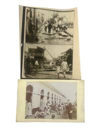
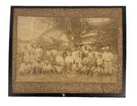
1928219181928. Puerto Rico during the early 20th century photo archive including the 1928 hurricane and colonial era life. Archive contains 3 silver gelatin photos with 2 photos being on one sheet. Each measure 8.5" x 11" to 5" x 9". One press photograph features two stacked photojournalistic images showing scenes of destruction in San Juan following the catastrophic hurricane of September 13 1928 one of the most devastating natural disasters to hit the island. The other photograph likely taken in the late 1910s is a mounted studio or missionary-style image depicting a white man standing in front of a long arched tenement-style structure surrounded by dozens of Puerto Rican women men and children many of the children barefoot and wearing minimal or tattered clothing. The larger image appears staged or observational and likely documents poverty in the aftermath of the U.S. acquisition of Puerto Rico following the Spanish-American War. The 1928 hurricane later named the San Felipe Segundo hurricane made landfall as a Category 5 storm killing over 300 people and rendering tens of thousands homeless. The press release photo captures the stark aftermath: corrugated roofs torn from buildings telephone poles shattered and citizens-both children and laborers-wandering through the wreckage-strewn streets of San Juan. These images reflect not only the physical devastation of the hurricane but also the lack of infrastructural resilience in a colony still reeling from U.S. economic control widespread poverty and racialized neglect by the mainland. The second image provides an unvarnished glimpse into the social realities of Puerto Rican life under U.S. rule during the 1910s. After the Foraker Act of 1900 and the Jones Act of 1917 which made Puerto Ricans U.S. citizens without granting them full constitutional rights the island experienced increasing political disenfranchisement and economic dependency. The presence of the white man-possibly a government official missionary or educator-visually underscores the racial and colonial dynamics at play. The surrounding community members including many children without shoes or shirts reflect systemic inequality and the enduring impacts of U.S. colonial policy on public health housing and education. Some edge wear tape on margins of smaller image and original editor's markings en verso to press photo. Overall very good condition. unknown
1853604771853. London: Printed by W. Clowes and Sons 1853. London: Printed by W. Clowes and Sons 1853. The First Compilation of the Laws of St. Lucia Saint Lucia. Laws at Present in Force in the Island of St. Lucia. London: Printed by W. Clowes and Sons 1853. vi 388 pp. Octavo 9-1/2" x 6". Contemporary calf with early rebacking red and black lettering pieces and small paper location label to spine upper lettering piece and endpapers renewed. Moderate rubbing to extremities some scuffing and edgewear to boards gilt red and black lettering pieces light toning to text internally clean. Ex-library. Old shelf label at head of spine small embossed stamps to boards inkstamp Bibliothek des Reichsgerichts to title page. A solid copy of a scarce title. $450. With index and side-notes. Saint Lucia was discovered by Columbus in 1502. The first group of colonists from England were massacred by the Caribs but the French succeeded in colonizing the island in 1642. It passed between France and Great Britain a number of times and became a British possession in 1803. It became independent and joined the Commonwealth in 1979. As one would suspect traces of French law remain in the island's legal system. The Reichsgerichtsbibliothek Imperial Court of Justice Library was at its peak Germany's largest and most important law library with 170000 works in its collection before the outbreak of the First World War. OCLC locates 9 copies in North America. Sweet & Maxwell A Legal Bibliography of the British Commonwealth 7:341. unknown
190530136London: Adam and Charles Black 1905. First edition. With 74 very fine and attractive colourplates from the paintings of Archibald Stevenson Forrest each with a captioned guard. Tall thick 8vo in the publisher's original pale blue cloth the upper cover and spine both decorated with ships craps clouds and sunbursts in brown ivory and gilt and with gilt lettering t.e.g. ix 272 4 ads pp. A handsome copy the plates all fine and bright some very occasional and light foxing within the text the lovely decorated binding is solid and firm with very little sign of wear but with a bit of mellowing to the spine front endpaper with cosmetic only spitting at the still-strong hinge. FIRST EDITION AND ONE OF THE MORE ELUSIVE TITLES IN BLACK'S TRAVEL SERIES A LOVELY BOOK IN FIRST AND ONLY EDITION. The blue seas and sun-drenched islands of the West Indies served as wonderful inspiration for both pen and paintbrush in this hard to find gem. Jamaica receives the lion's share of attention but other subjects include Barbadoes St. Lucia Dominica St. Thomas and Martinique. Archibald Forrest wonderfully captures the bright colourful scenery and colourful peoples of these tropic isles. Adam and Charles Black hardcover
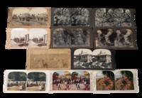
1890231711890. Stereoview archive of the post-emancipation Caribbean showing how the islands were marketed to western viewers through plantation labor export agriculture civic spectacle and catastrophe. As a group these photos function not only as an ethnographic travel archive but as evidence of the visual economy that followed slavery. The British West Indies moved through emancipation in 1834 to 1838 the French Caribbean in 1848 Puerto Rico in 1873 and Cuba in 1886 yet plantation production remained central to regional life well into the early twentieth century. These stereoviews preserve a colonial way of seeing in which Black and Afro-Caribbean labor rural discipline and extractive agriculture remained the background condition of "tropical" beauty and commercial modernity. Cuba's sugar economy in particular expanded through the nineteenth century and slavery was not abolished there until 1886 while Weyler's later reconcentration policy during the Cuban War of Independence violently reorganized rural life. Martinique after 1848 likewise shifted into new labor regimes including imported workers from India and China.<br /> <br /> Archive of 11 stereoview cards late 1890s to early 1900s depicting Cuba Jamaica Martinique Puerto Rico and the Dominican Republic. Most black and white with a few colorized. Each measure 3.5" x 7". All with captions on the margins. "Reconcentrado Farming Scene Province of Havana Cuba" links agricultural production to the brutal displacements of Spain's reconcentration campaign; "Cutting sugar cane Montego Bay Jamaica W.I." records cane labor in a colony where emancipation had not ended plantation dependency; and "Harvesting Coconuts Porto Rico" likewise frames Caribbean land through export work rather than local life. Other views extend that economic framing through cacao and coffee scenes while the paired Havana cards shift into urban leisure and public display including "Beautiful Central Park Havana Cuba" and "Holiday in Havana Cuba" the latter with both Cuban and American flags visible a telling image of the new imperial order after 1898. The disaster views from Martinique and the Lesser Antilles show how stereoview publishers also turned Caribbean destruction into consumable spectacle. the Morne Rouge card is accompanied on the reverse by the grim printed text "Dead bodies which were to be seen in Morne Rouge." while the wider context is the 1902 eruptions of Mount Pelée in Martinique and La Soufrière on Saint Vincent two catastrophes that killed roughly 30000 and 1600 people respectively and devastated local communities and agriculture.<br /> <br /> Some corner wear light toning scattered surface and edge wear. Overall very good condition. This collection gives direct visual representation of Caribbean history Atlantic slavery and emancipation plantation labor and U.S. imperial expansion in the circum-Caribbean preserving the transition from slavery to post-abolition labor. unknown
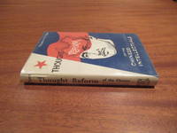
1960025662Hong Kong: Hong Kong University Press / Oxford University Press / Institute of Pacific relations 1960. First Edition First Printing . Hardcover. Near Fine/Near Fine Dustjacket. Xiii 247. Orange Cloth. One Of 2000 Copies Of The First Printing But This Copy With Printed $5 Us Price At Bottom Of Front Flap So Perhaps An American Issue. Slight Signs Of Usage To Book And Dj. Inscribed To Mr. And Mrs. Z. T. Nyi Zau Tsung Nyi Of Los Angeles "With High Esteem And Respect". Information From His Archives At Usc: Theodore H.E. Chen Ph.D. 1939 Was Chairman Of Usc's Department Of Asian Studies From 1940 To 1968 And From 1960 To 1971 He Directed The East Asian Studies Center In Support Of Which He Had Obtained The First Federal Grants. Chen Also Secured Outside Funding For A Project To Help Train And Advise High School Teachers Of Chinese And Japanese. A Native Of Fuzhou China Chen Was President Of Fukien Christian University In 1946 And 1947 While On Leave To Participate In Postwar Rehabilitation. He Also Helped Organize Tunghai University In Taiwan As A Representative Of The United Board Of Christian Colleges. He Was The Author Of Nine Books Including Thought Reform Of Chinese Intellectuals And Maoist Educational Revolution And Chinese Education. Dr Chen Hits An Easy Target; The Worst Governments Are Those Who Try To Control What And How People Think And How And Where They Communicate Because Their Leaders Have An Excess Of The Oldest Disease Of Officials Crap-In-The-Brain Which Prevents Them From Engaging In Exchanges Of Facts And Ideas. <br/> <br/> Hong Kong University Press / Oxford University Press / Institute of Pacific relations hardcover
1916biblio1324<p>This is an unusual first printing from 1916---extremely rare in this propitious 100-year anniversary a year featuring the reopening of normal relations and the visit of the U.S. President. This volume which describes in prase charts and photos the favorable advantages of 1916 Cuba may be one of the few that exist in the original state---there do not appear to be any offered in the marketplace making it an ideal addition to any collection of historical Cuba-related items.</p><p>Photos on request.</p> Foreign Publishing Company hardcover
1890208021890. Unidentified photographers two albumen photographs of Black laborers circa 1890s to early 1900s document agricultural and skilled work performed by African Americans in the decades following emancipation when systems of sharecropping and tenant farming structured rural economies across the American South and parts of the Caribbean. These images provide visual evidence of labor organization racial hierarchy and economic dependency that persisted after the formal end of slavery with large groups of Black workers shown in relation to white overseers or employers. One photograph presents approximately forty five Black men gathered around three centrally seated white men emphasizing supervisory roles and social stratification within plantation labor systems. The clothing of the workers including cotton shirts loose trousers and wide brimmed hats reflects adaptation to agricultural work in hot climates while a smaller number of individuals in jackets and pocket watches suggests internal distinctions within Black labor communities. The second image depicts six Black carpenters engaged in coordinated manual work at an outdoor shop indicating the presence of skilled trades alongside agricultural labor.<br /> <br /> Group of two albumen photographs mounted on original cardstock measuring approximately 8 x 9.5 inches and 10 x 12 inches. The larger photograph shows an outdoor woodworking scene with six men using tools including a hammer and saw working under a thatched structure suggestive of southern or Caribbean environments. The second photograph shows a large assembled group of plantation workers with three white men seated at center. Faint pencil annotations appear in the margins of one mount. Both photographs retain strong compositional clarity with figures arranged to emphasize both collective labor and hierarchical relationships.<br /> <br /> These photographs contribute to the study of post emancipation Black life by documenting how agricultural dependency and limited access to capital shaped labor conditions into the late nineteenth and early twentieth centuries. The plantation scene illustrates the persistence of racially stratified labor organization while the carpentry image provides evidence of skilled Black tradesmen operating within local economies often without institutional support or pathways to independent enterprise. The visual contrast between collective field labor and artisanal work expands the interpretive scope of the archive situating these images within broader histories of labor race and economic transition following the end of slavery. Edge wear and minor chipping to mounts with noticeable foxing to one image primarily at the margins; images remain legible and structurally intact. Overall good condition. unknown
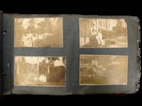
1914231551914. Caribbean photograph album likely compiled by a person connected to the Panama Canal Zone and the Caribbean documenting how steamship mobility port circulation and U.S. imperial presence linked Jamaica Venezuela Trinidad Barbados Cuba Puerto Rico the Bahamas Florida and Panama in the years after the canal opened. The felt cover lettered "PANAMA" and bearing the Seal of the Canal Zone places the album within the new travel geography created by U.S. control of the Canal Zone and the canal's 1914 opening when Panama became a central hinge between Atlantic and Pacific movement and a major point of contact between North American travelers and Caribbean port cities. Photos show passengers on steamers and docks markets and streets forts and government buildings and repeated encounters between white visitors and Afro Caribbean and mixed-heritage residents across multiple colonial and semi-colonial settings.<br /> <br /> Panama Canal Zone travel photograph album. Caribbean and circum-Caribbean locations including Kingston Jamaica; La Guaira and Caracas Venezuela; Trinidad; Key West and Palm Beach Florida; Havana Cuba; Barbados; Panama City Balboa and Colón Panama; Nassau Bahamas; and San Juan Puerto Rico. Likely circa mid 1910s to early 1920s. Oblong felt-covered album measuring 6.5" x 11" with "PANAMA" stitched in large letters on the front cover and photographs pasted to grey leaves. Contains more than 160 black-and-white photographs most approximately 2.5 x 4.5 inches many with handwritten captions identifying locations activities and occasional names. The sequence opens in Kingston with captions including "Kingston JA" and "on the steamer" then moves through island and mainland stops; "Port of Spain Trinidad" "Market at Barbados" "Rapid Transit Barbados" "Havana Cuba" "San Juan Porto Rico" "Morro Castle" "Balboa" and "Colon R.P." Repeated figures especially a young college-aged woman and an older woman appear throughout. Notable images include a group of locals in shallow water at Barbados sifting for tossed coins from rowboats; a large crowd scene in San Juan gathered for what appears to be a public speech or civic event; battlements cannon and stone defenses in Havana; vernacular dwellings and children in impoverished conditions in Balboa; posed visitor photographs in what is labeled a "bull ring"; and numerous street dockside market and architectural views that juxtapose local populations with hotels public buildings ruins and newer urban construction.<br /> <br /> The album's historical force comes from the way it captures the social landscape of Caribbean travel under early twentieth-century U.S. power. After 1914 the Canal Zone intensified Panama's role within a wider American maritime sphere while Caribbean travel increasingly moved through port infrastructures shaped by empire commerce military strategy and tourism; this album records that world at eye level with photographs of docks steamers fortifications government sites public squares and local street life rather than limiting themselves to family snapshots alone. At the same time the images preserve the unequal human encounters built into that system especially where visitors photograph Black children boatmen market crowds and working neighborhoods as part of the travel experience. Felt cover worn and soiled with losses at edges and stitching strain; leaves brittle with chipping and tears; photographs generally present and legible with silvering fading corner wear and occasional losses or lifting. Overall fair to good condition. A substantial early twentieth-century visual record of Canal Zone connected Caribbean travel with dense captioning and wide geographic reach from Jamaica and Barbados to Havana San Juan and Panama. unknown
17970006092<p>Boston: S. Hall and Thomas & Andrews 1797. First Edition. Hardcover. Good. 7 Maps. Octavo new full brown calf red spine label new endpapers minor foxing. Ex libris Robert Breck in 1798 on title-page and on flyleaf minor repairs to folds of frontispiece folding map. . <br /><br />Capt. Thomas Hutchins the U. S. General Geographer supplied his notes to assist Morse the "Father of American Geography" in the completion of this work. This copy includes the map of "Georgia Western Territory" which was not incorporated in many of the copies. Howes M839; Evans 32509; not in Graff; Sowerby 3964; Sabin 50923 John Carter Brown 3902; Buck ILLINOIS 53. Contains 7 maps.</p> S. Hall, and Thomas & Andrews hardcover
18560006868New York: D. Appleton 1856. First edition. Hardcover. fine. 12mo xii 412 pages original light brown embossed cloth. <br/><br/>These observations are related in a series of 61 letters. These were originally composed in Spanish then translated into English by Joseito. "I have thereby been enabled to impart entirely new data and reliable information instead of merely copying from books already known. . I applied myself to natives who besides an intimate knowledge of affairs in general possessed a sound judgment and an investigating disposition. It has beeen indeed a very happy incident to have found them. . That part of my work which treats on judicial matters and the secrets of the management of the tribunals will especially attract the attention of my readers. - Introductory Letter." Sabin 17816; Treiles BIBLIO. CUBANA vo. 4 p.17. D. Appleton hardcover
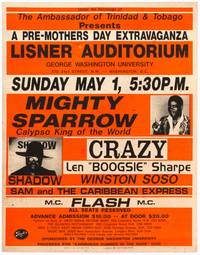
1988564096Landover Maryland / Washington D.C.: Special Effects Inc. / George Washington University 1988. Softcover. Very Good. Poster. Measuring 22" x 28". Printed in orange and black on thick coated card stock. Staple holes some foxing and soil a very good copy of a scarce poster advertising a 1988 performance by some of the world's greatest Calypso artists. Special Effects Inc. / George Washington University unknown
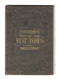
185578137New York: G.W. & C.B. Colton 1855. Hand-colored lithograph map of the Caribbean showing Florida and Central America with insets of Bermuda and the city and harbor of Havana. This example is colored according to national allegiance with British territories in red Spanish in yellow and so on.<br />  <br /> The map is printed on a 17†x 14 ¾†sheet of banknote paper and folds into brown cloth-covered boards with gilt titles. Some light foxing with a few small spots. There is a bit of creasing along the right margin not affecting the image. The boards are rubbed and faded with some light soiling as well. G.W. & C.B. Colton unknown
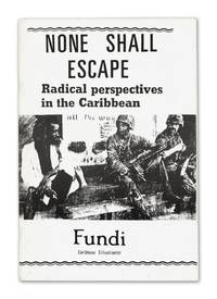
140948802London: News from Everywhere 1988. First edition. Fine. First edition. 21 pp. Staple bound in publisher's printed wraps. Fine condition; lacking folding map originally laid in. Rare with only nine copies located in OCLC. Ford 245.<br /> <br /> <p>The key text of the one-man Caribbean Situationist movement which was inspired by the '60s Paris-centered avant garde Marxist group the Situationist International. It comprises the three essays "Radical Perspectives in the Caribbean" "What Padmore Passed Through" about Pan-Africanist leader George Padmore and "The Adventures of Westmoreland" about labor struggles in a southwestern parish in Jamaica. News from Everywhere unknown
9210210492New. Brand new and still unused unknown
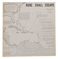
140948116London: Caribbean Situationist 1973. First edition. Original pressing. Vinyl LP in sleeve complete with both poster inserts. Very Good album deep scratch to first track of Side 1 other than that the wear is light; tiny nick to label on Side 1. Sleeve Near Mint slightly bumped bottom corner very slight rubbing and toning. Hint of foxing to the map poster else the posters are Fine folded in fours as issued.<br /> <br /> <p>A very rare spoken word album of sorts by the Jamaican refrigerator repairman and labor organizer Joseph Edwards under the nom de plume Fundi the Caribbean Situationist. He was inspired by the French-based radical Marxist group The Situationist International who played an important role in the May 1968 student revolt in Paris there were also Scandinavian British and American grouplets that were forever clashing with co-founder Guy Debord in Paris. to start a one-man Caribbean offshoot combining Debord's philosophy with Rastafarianism Trotskyism Black Power and syndicalism. A fascinating document of avant garde politics and media analysis in the Third World during the 1970s. Caribbean Situationist unknown
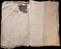
1898List2965United States and Caribbean 1898. Approximately twenty-nine pieces: logbook of eighty-four double-sided pages measuring 13 x 20 inches; eight letters seventeen documents and forms and three pieces of miscellany. Much wear and significant damage to logbook including water damage mildew and tearing; log book overall fair to good minus. Other materials good to very good. Overall good. William Higgins 1791–1872 was a farmer sea captain and owner of and investor in ships from Bowdoinham Maine. According to the Maine Maritime Museum which holds his family papers Higgins’ ships traded mainly in lumber which they took from Wilmington North Carolina to the Caribbean.<br /> <br /> Offered here is a logbook recording the travels of several of Higgins’ ships particularly the brigs Mary Jane and Llewellyn alongside related documents and personal letters. The logbook dating between 1832 and 1836 extensively documents the course wind data and weather remarks for travels of the ships between east coast US port cities and various locations in the Caribbean including Barbados St. Thomas and Martinique. The logbook also contains a copy of astronomer and mathematician Elijah Burritt’s illustration “A Plan of the Solar System Exhibiting its Relative Magnitudes and Distances†engraved by W. G Evans and printed in 1835 by F.J. Huntington.<br /> <br /> The letters and documents date from 1830 to 1867 and are also mostly business-related including an insurance document for the brig William Parrington a roll of sailors enlisted to work on a six-month journey between the Caribbean and the US in 1845 a bill of sale for ¼ stake in the brig Mary Jane and receipts and logs for items including various liquors sugar molasses casks and so on. One letter from a young man in Wilmington requests advice on how to start his own business in the style of Higgins’; other letters concern family matters. One interesting undated document is a writ addressed to the Marshal of the District of Maine concerning a lawsuit filed against Higgins and Rufus Carr master of the William Parrington by Zachrisson Nelson Co. The suit alleged that Carr acting as an agent for the ship’s owners that is Higgins had agreed to an affreightment involving shipping from Jamaica to Spain to New York but had then “wholly neglected and refused to do soâ€.<br /> <br /> Of interest to scholars of maritime history and trade in the mid-19th century. unknown
1592026339Frankfurt am Main 1591 1592. Original Antique Map . Single Sheet. Near Fine. Laid Paper. Size: Image And Border Approximately 17 7/8 Inches X 1M.5 Inches 45.2 Cm X 36.75 Cm. Debry Printed His Voyage To Virginia In 1590 As Part I Of His Works But Burden Mapping Of North America Provides No Record That A 1592 Printing Exists. This Map Has No Center Fold But Contemporary Engravings Exist Of The Offices Of The Great 17Th Century Cartographic Publishers With Row Upon Row Of Flat Drawers For Storage Of Single Maps; It Would Be Unreasonable To Believe That None Of These Unbound Maps Survived. This Appears To Be One Of Them Although The Consensus Of Modern Dealers Is That No Unfolded Large Map First Published In A Book Can Exist. Although We Have Been Unable To Locate A 1592 German Edition Of Debry We Believe This Is A Map As Issued In The 1592 German Edition Of De Bry Which Was First Published In 1591 And Subsequently Reprinted In 1592 And 1594 And In The Seventeenth Century. Small Cartouche At Lower Left Monogram With Text "Caesavece Matis. Privilegio Mdxcii" In The Plate Added After Original 1591 Printing. This Is An Unfolded Sheet Which Was Never Bound In A Book; A Strong Impression Without Damage And With Old Light Partial Coloring. Once Quite Aged Then Professionally Cleaned De-Acidified And Mounted Loosely With Archival Materials By A Museum-Experienced Conservator In About 2000. Scarce. And Now 430 Years Later It's Depicting A Hangout For Orangutans. <br/> <br/> unknown