MOREAU de SAINT-MERY (Médéric Louis Elie);Livre Rare Book
754 résultats
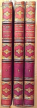
18758011L. Guerin et Cie Paris 1875 4 vol. 3 vol. grand in-8 de 4 ff.n.ch. XXXI 446 pp., 2 ff.n.ch. 466 pp. et 2 ff.n.ch. 502 pp. + un atlas in-folio de 1 f.n.ch. (titre) 30 feuillets 1 f.n.ch. (table), demi-chagrin de l'époque, dos à nerfs orné.
177514603par la Compagnie Trévoux 1775 4 vol. 4 vol. in-12 de 6 ff.n.ch. (titre et préface) 394 pp. 1 f.n.ch., 1 f.n.ch. (titre) 428 pp., 1 f.n.ch. (titre) 346 pp. et 1 f.n.ch. (titre) LX 356 pp. 1 f.n.ch. (table), veau fauve de l'époque, dos à nerfs orné, pièces de titre et de tomaison, tranches rouges (certains mors restaurés et accroc à une coiffe).
FIRST AND ONLY EDITION OF THIS ATLAS OF THE BRITISH WEST INDIES, published in France during the Seven Years' War (also known as the "French and Indian War".) xii, 171 pp + engraved title and THIRTEEN FINE MAPS, of which 8 are folding (complete). Also illustrated with ten headpieces, nine of which depict the entry into a major port. Includes Jamaica (with several maps), Barbuda, St. Kitts, Nevis, the Virgin Islands, Anguilla, Antigua, the Lucayes (now the Bahamas), and Bermuda. 4to (26 x 20.3 cm). Attractively bound in contemporary calf, with the ARMS OF KING LOUS XV OF FRANCE EMBLAZONED IN GILT ON FRONT AND BACK COVERS. Binding restored at head and tail of spine, and very solid. Small, faint marginal stain to engraved title-page, else INTERNALLY FINE AND BRIGHT, WITH MAPS AND TEXT VERY FRESH. Sabin 4553. RARE AND IMPORTANT.
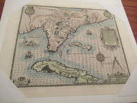
1592026339Frankfurt am Main 1591 1592. Original Antique Map . Single Sheet. Near Fine. Laid Paper. Size: Image And Border Approximately 17 7/8 Inches X 1M.5 Inches 45.2 Cm X 36.75 Cm. Debry Printed His Voyage To Virginia In 1590 As Part I Of His Works But Burden Mapping Of North America Provides No Record That A 1592 Printing Exists. This Map Has No Center Fold But Contemporary Engravings Exist Of The Offices Of The Great 17Th Century Cartographic Publishers With Row Upon Row Of Flat Drawers For Storage Of Single Maps; It Would Be Unreasonable To Believe That None Of These Unbound Maps Survived. This Appears To Be One Of Them Although The Consensus Of Modern Dealers Is That No Unfolded Large Map First Published In A Book Can Exist. Although We Have Been Unable To Locate A 1592 German Edition Of Debry We Believe This Is A Map As Issued In The 1592 German Edition Of De Bry Which Was First Published In 1591 And Subsequently Reprinted In 1592 And 1594 And In The Seventeenth Century. Small Cartouche At Lower Left Monogram With Text "Caesavece Matis. Privilegio Mdxcii" In The Plate Added After Original 1591 Printing. This Is An Unfolded Sheet Which Was Never Bound In A Book; A Strong Impression Without Damage And With Old Light Partial Coloring. Once Quite Aged Then Professionally Cleaned De-Acidified And Mounted Loosely With Archival Materials By A Museum-Experienced Conservator In About 2000. Scarce. And Now 430 Years Later It's Depicting A Hangout For Orangutans. <br/> <br/> unknown