CARIBE [Hector Julio Paride Bernabo]Biblio.com
248 résultats
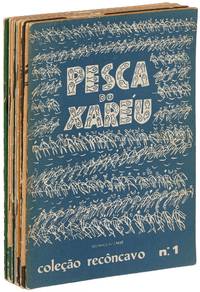
1955593625Bahia Brasil: Livraria Progresso 1955. Softcover. Very Good. First editions. Illustrated by Caribé. Nine volumes lacking the 10th Orixás. Slim octavos. Stapled wrappers. Text in Portuguese. Moderate tanning and wear wrappers with some foxing and soiling topedges with a small splash of white paint sound and near very good. Each volume prints illustrations by Caribé from the Bahia State Museum as well as text by Caribé Odorico Tavares Vasconcelos Main José Pedreira or Carlos Eduardo. Each also has a number stamp on the copyright page from an unknown limitation. The titles are: A pesca do xaréu; Pelourinho; O jogo da capoeira; Feira de água de meninos; Festa do bonfim; Conceicão da praia; Festa de yemanjá; Rampa do mercado; and Temas de candomblé. Livraria Progresso unknown
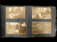
1914231551914. Caribbean photograph album likely compiled by a person connected to the Panama Canal Zone and the Caribbean documenting how steamship mobility port circulation and U.S. imperial presence linked Jamaica Venezuela Trinidad Barbados Cuba Puerto Rico the Bahamas Florida and Panama in the years after the canal opened. The felt cover lettered "PANAMA" and bearing the Seal of the Canal Zone places the album within the new travel geography created by U.S. control of the Canal Zone and the canal's 1914 opening when Panama became a central hinge between Atlantic and Pacific movement and a major point of contact between North American travelers and Caribbean port cities. Photos show passengers on steamers and docks markets and streets forts and government buildings and repeated encounters between white visitors and Afro Caribbean and mixed-heritage residents across multiple colonial and semi-colonial settings.<br /> <br /> Panama Canal Zone travel photograph album. Caribbean and circum-Caribbean locations including Kingston Jamaica; La Guaira and Caracas Venezuela; Trinidad; Key West and Palm Beach Florida; Havana Cuba; Barbados; Panama City Balboa and Colón Panama; Nassau Bahamas; and San Juan Puerto Rico. Likely circa mid 1910s to early 1920s. Oblong felt-covered album measuring 6.5" x 11" with "PANAMA" stitched in large letters on the front cover and photographs pasted to grey leaves. Contains more than 160 black-and-white photographs most approximately 2.5 x 4.5 inches many with handwritten captions identifying locations activities and occasional names. The sequence opens in Kingston with captions including "Kingston JA" and "on the steamer" then moves through island and mainland stops; "Port of Spain Trinidad" "Market at Barbados" "Rapid Transit Barbados" "Havana Cuba" "San Juan Porto Rico" "Morro Castle" "Balboa" and "Colon R.P." Repeated figures especially a young college-aged woman and an older woman appear throughout. Notable images include a group of locals in shallow water at Barbados sifting for tossed coins from rowboats; a large crowd scene in San Juan gathered for what appears to be a public speech or civic event; battlements cannon and stone defenses in Havana; vernacular dwellings and children in impoverished conditions in Balboa; posed visitor photographs in what is labeled a "bull ring"; and numerous street dockside market and architectural views that juxtapose local populations with hotels public buildings ruins and newer urban construction.<br /> <br /> The album's historical force comes from the way it captures the social landscape of Caribbean travel under early twentieth-century U.S. power. After 1914 the Canal Zone intensified Panama's role within a wider American maritime sphere while Caribbean travel increasingly moved through port infrastructures shaped by empire commerce military strategy and tourism; this album records that world at eye level with photographs of docks steamers fortifications government sites public squares and local street life rather than limiting themselves to family snapshots alone. At the same time the images preserve the unequal human encounters built into that system especially where visitors photograph Black children boatmen market crowds and working neighborhoods as part of the travel experience. Felt cover worn and soiled with losses at edges and stitching strain; leaves brittle with chipping and tears; photographs generally present and legible with silvering fading corner wear and occasional losses or lifting. Overall fair to good condition. A substantial early twentieth-century visual record of Canal Zone connected Caribbean travel with dense captioning and wide geographic reach from Jamaica and Barbados to Havana San Juan and Panama. unknown
9211212650.Gpaperback. Good. Access codes and supplements are not guaranteed with used items. May be an ex-library book. paperback
1528327918.Gpaperback. Good. Access codes and supplements are not guaranteed with used items. May be an ex-library book. paperback
2005G0435988018I3N00Heinemann International Literature and Textbooks 2005. Paperback. Good. Pages can have notes/highlighting. Spine may show signs of wear. ~ ThriftBooks: Read More Spend Less.Dust jacket quality is not guaranteed. Heinemann International Literature and Textbooks paperback
1408509059New. Brand new and still unused unknown
1408508982.Gpaperback. Good. Access codes and supplements are not guaranteed with used items. May be an ex-library book. paperback
1408509059.Gpaperback. Good. Access codes and supplements are not guaranteed with used items. May be an ex-library book. paperback
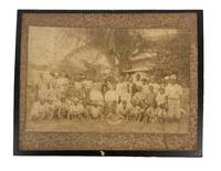
1890208021890. Unidentified photographers two albumen photographs of Black laborers circa 1890s to early 1900s document agricultural and skilled work performed by African Americans in the decades following emancipation when systems of sharecropping and tenant farming structured rural economies across the American South and parts of the Caribbean. These images provide visual evidence of labor organization racial hierarchy and economic dependency that persisted after the formal end of slavery with large groups of Black workers shown in relation to white overseers or employers. One photograph presents approximately forty five Black men gathered around three centrally seated white men emphasizing supervisory roles and social stratification within plantation labor systems. The clothing of the workers including cotton shirts loose trousers and wide brimmed hats reflects adaptation to agricultural work in hot climates while a smaller number of individuals in jackets and pocket watches suggests internal distinctions within Black labor communities. The second image depicts six Black carpenters engaged in coordinated manual work at an outdoor shop indicating the presence of skilled trades alongside agricultural labor.<br /> <br /> Group of two albumen photographs mounted on original cardstock measuring approximately 8 x 9.5 inches and 10 x 12 inches. The larger photograph shows an outdoor woodworking scene with six men using tools including a hammer and saw working under a thatched structure suggestive of southern or Caribbean environments. The second photograph shows a large assembled group of plantation workers with three white men seated at center. Faint pencil annotations appear in the margins of one mount. Both photographs retain strong compositional clarity with figures arranged to emphasize both collective labor and hierarchical relationships.<br /> <br /> These photographs contribute to the study of post emancipation Black life by documenting how agricultural dependency and limited access to capital shaped labor conditions into the late nineteenth and early twentieth centuries. The plantation scene illustrates the persistence of racially stratified labor organization while the carpentry image provides evidence of skilled Black tradesmen operating within local economies often without institutional support or pathways to independent enterprise. The visual contrast between collective field labor and artisanal work expands the interpretive scope of the archive situating these images within broader histories of labor race and economic transition following the end of slavery. Edge wear and minor chipping to mounts with noticeable foxing to one image primarily at the margins; images remain legible and structurally intact. Overall good condition. unknown
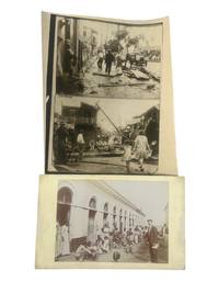
1928219181928. Puerto Rico during the early 20th century photo archive including the 1928 hurricane and colonial era life. Archive contains 3 silver gelatin photos with 2 photos being on one sheet. Each measure 8.5" x 11" to 5" x 9". One press photograph features two stacked photojournalistic images showing scenes of destruction in San Juan following the catastrophic hurricane of September 13 1928 one of the most devastating natural disasters to hit the island. The other photograph likely taken in the late 1910s is a mounted studio or missionary-style image depicting a white man standing in front of a long arched tenement-style structure surrounded by dozens of Puerto Rican women men and children many of the children barefoot and wearing minimal or tattered clothing. The larger image appears staged or observational and likely documents poverty in the aftermath of the U.S. acquisition of Puerto Rico following the Spanish-American War. The 1928 hurricane later named the San Felipe Segundo hurricane made landfall as a Category 5 storm killing over 300 people and rendering tens of thousands homeless. The press release photo captures the stark aftermath: corrugated roofs torn from buildings telephone poles shattered and citizens-both children and laborers-wandering through the wreckage-strewn streets of San Juan. These images reflect not only the physical devastation of the hurricane but also the lack of infrastructural resilience in a colony still reeling from U.S. economic control widespread poverty and racialized neglect by the mainland. The second image provides an unvarnished glimpse into the social realities of Puerto Rican life under U.S. rule during the 1910s. After the Foraker Act of 1900 and the Jones Act of 1917 which made Puerto Ricans U.S. citizens without granting them full constitutional rights the island experienced increasing political disenfranchisement and economic dependency. The presence of the white man-possibly a government official missionary or educator-visually underscores the racial and colonial dynamics at play. The surrounding community members including many children without shoes or shirts reflect systemic inequality and the enduring impacts of U.S. colonial policy on public health housing and education. Some edge wear tape on margins of smaller image and original editor's markings en verso to press photo. Overall very good condition. unknown
1408516497.Gbundle. Good. Access codes and supplements are not guaranteed with used items. May be an ex-library book. unknown
197324847Bridgetown Barbados: CADEC 1973. Second Edition. Quarto 27.5cm.; original white pictorial staplebound wrappers printed in green and black; 59pp.; illus. Mild dust soiling else Fine. Guide and objectives of the Consultation as formed by the Caribbean Conference of Churches. Originally published as a report of the first Consultation held in 1971. CADEC unknown
38547920like new. unknown
5120783-nnew. unknown
5120783like new. unknown
1942ZB382805Cascade: Trinidad and Tobago Medical Associations 1942-70. volumes 4#2; 6#2; 11#1-2; 12#1/2; 13#1/2; 17#1/2; 21#1/4; 21#1/4; 23#1/4; 26#1/4; 30#1/4; 31/32#1/4 original paper wrappers minor library markings & with some bibliographic data corrected in pen; good; Price is for the lot. - If you are reading this this item is actually physically in our stock and ready for shipment once ordered. We are not bookjackers. Buyer is responsible for any additional duties taxes or fees required by recipient's country. Photos available upon request. Cascade: Trinidad and Tobago Medical Associations unknown
1947ZB588037Port-of-Spain Trinidad British West Indies: 1947-1951. Volumes 1 through 4 only; ex library all in later cloth the second volume lacks original paper sides but others retained good. - If you are reading this this item is actually physically in our stock and ready for shipment once ordered. We are not bookjackers. Buyer is responsible for any additional duties taxes or fees required by recipient's country. Port-of-Spain, Trinidad, British West Indies: hardcover
1947ZB573157Port-of-Spain Trinidad British West Indies: 1947-1959 passim. Volume 1 Numbers 6 August 1947-12; Volume 2 complete in 12 issues; Volume 3 complete in 12 issues; Volume 4 Numbers 1-11; Volume 5 Numbers 2-4 6 8-12; Volume 6 Numbers 1-6; Volumes 7 Numbers 1-4 6-12; Volume 8 Numbers 1-3 6-12; Volume 9 Numbers 1-11; Volume 10 Numbers 1 3-12; Volume 11 complete in 12 issues; Volume 12 complete in 5 issues; Volume 13 complete in 12 issues; all in original paper wrappers some have library markings overall a good group. - If you are reading this this item is actually physically in our stock and ready for shipment once ordered. We are not bookjackers. Buyer is responsible for any additional duties taxes or fees required by recipient's country. Photos available upon request. Port-of-Spain, Trinidad, British West Indies: unknown
9766001251.Gpaperback. Good. Access codes and supplements are not guaranteed with used items. May be an ex-library book. paperback
1821200023AG1821. Paris Brué 1821. Original engraving. Plate Size: 50.5 cm x 36.1 cm. Sheet Size: 68 cm x 54.1 cm. Original map. Very good condition. Extra wide margins. Some minor foxing along sheet edges. Discreet author's blind stamp with 'Carte Encyprotipe' and initials 'AB' embossed in top corner of map. Centre-fold as issued. Border with longitudinal and latitudinal information. Detailed early map of the Caribbean from an early edition of Brue's Atlas Universel Pl.35. Rich detail in Florida the Gulf Coast Central America. The eye is drawn to Cuba among the islands of the 'Grandes' and 'Petites' Antilles. As demonstrated by the map's political divisions and colourings Mexico has yet cede control of what will become Texas. Nouva Espagne and Nouv Grenade show that the aged and tottering Spanish empire has still to fall in Central and South America. The division of Hispaniola into its Haitian and Dominican parts is also shown. The great port cities of the infant United States - Charlestown Savannah and New Orleans - can be seen along the seaboard. Bermuda is shown breaching the map's top border. Reference keys and explanatory annotations and four scale-bars in lower left corner of map. Decorative title in top right corner of map. Adrien-Hubert Brué 1786 - 1832 was a renowned French cartographer. Between 1810 and 1830 Brué established himself as one of the most important French cartographers and it was during this period that his two most important works were published: Grand Atlas Universel in 1815 and Atlas Universel in 1822 which ran to several editions. Atlas Universel was published as a continuation to Grand Atlas Universel. Brués maps or cards as they were referred to at the time were characterized by the high degree of accuracy with which they were produced and the meticulous attention to detail employed in their crafting. This was possible due to Brués application of copper plate intaglio to the process of mapmaking or as Nouvelles Annales des Voyages et des Sciences Géographiques had it: by applying to the making of cards this ingenious process of drawing on copper itself. Alexandre von Humboldt the President of the Société de géographie de Paris praised the accuracy of his work and clarity that is all the more pleasing to the eye. He also was quick to update his maps with the latest scientific discoveries and nautical measurements. Wikipedia unknown
1408517469.Gpaperback. Good. Access codes and supplements are not guaranteed with used items. May be an ex-library book. paperback
1408509075.Gpaperback. Good. Access codes and supplements are not guaranteed with used items. May be an ex-library book. paperback
1408509083.Gpaperback. Good. Access codes and supplements are not guaranteed with used items. May be an ex-library book. paperback