196 résultats
Mappa del 1850 di Australia e Polinesia di F. V. Stulpnagel. Autore: F. V. Stulpnagel Data: 1850 Tecnica: Incisione su rame Dimensione della pagina: 31x39,5 cm Dimensione dell'incisione: 30x38,5 cm Condizioni: Ottime Map of 1850 of Australia and Polinesia by F. V. Stulpnagel. Author: F. V. Stulpnagel Date: 1850 Technique: copper engraving Leaf Dimension: 31x39,5 cm Engraving Dimension: 30x38,5 cm Conditions: Very good conditions.
In folio. Dim. 58x43 cm. Pp. 4. Numero del 11 febbraio 1903 di questo raro quotidiano fondato a Roma nel 1901 e chiuso nel 1973. All'interno: Rottura delle relazioni tra Menelich e il Ministro di Francia, Rivolta a Berlino, La Polinesia francese devastata dai cicloni, La condanna di Rubino ai lavori forzati a vita, Catania, Caserta, Avellino, Siracusa, La sentenza del Tribunale di Torino sul processo Stampa Poli Pantaleoni, delitto misterioso di Roma in via XX settembre, pubblicità d'epoca. In buone condizioni. Raro. Brossura editoriale in buone condizioni generali con lievi usure ai margini e dorso. Piegature e qualche piccolo strappo. All'interno le pagine si presentano in buone condizioni con rare fioriture. Piegature. Number of the 11st of february 1903 of this scarce daily newspaper established in Rome in 1901 and closed in 1973. Inside: Crack of relations between Menelich and the Ministery of FRance, Riot in Berlin, French Polinesia devasted by rain, the condamnation of Rubino, Catania, Caserta, Avellino, Siracusa, La sentence fo the Trial of Torino about trial Stampa Poli Pantaleoni, mysterious murder of Rome in via XX settembre, advertisings. In good conditions. Scarce copy Editorial cover in good general conditions slightly worn in the edges and spine. Foldings and some little tears. Inside pages are in good conditions with occasional foxings.
86, [2] pp., ill. a colori n.t.; 19 cm. Leg. edit. Piccola etichetta alla prima pagina. Buono
Wien, Museum für Völkerkunde, s.d. (anni ‘60), in-8, br., pp. 38. Con ill. in b.n. e nota bibliografica.
(Napoli, Vincenzo Orsino, 1787), in-8, privo di legatura, pp. 330 (su 332). Primo volume (su 6) dell'edizione napoletana apparsa fra il 1787 e il 1790. Mancano le prime 2 cc. bb. e le cc. iniziali contrassegnate in nn. romani (XVI), con occhietto e frontespizio. Il testo s'interrompe in fine alla lettera "G" dell'elenco alfabetico degli associati. E' presente una brunitura ai margini interni, che diventa più evidente nella seconda metà del volume.
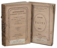
1863ABC_47184Papeete: Imprimerie du Gouvernement 1863. Original publisher's printed wrappers. Small 8vo. With two original photographs in the 1863 edition both reproducing maps one showing the islands Tahiti and Moorea and the other showing archipels which were then under French protectorate. 2 volumes. With: 2 IDEM. Annuaire des établissements français de l'Océanie et du Protectorat des Iles de la Société et dépendances pour l'an 1864 title on the front wrapper: Annuaire de Taïti pour 1864.Papeete Imprimerie du Gouvernement October 1864. Two very rare issues of an administrative annual periodical in the form of an almanac on Tahiti Moorea and other parts of French Polynesia printed in Papeete the capital of French Polynesia and Tahiti. In 1842 the French proclaimed the protectorate over the islands and atolls in the different archipelagos of French Polynesia including Tahiti which is the most populous island. Both issues contain a calendar in addition to the many pages listing various members of the local and colonial government and judiciary. Both issues also contain demographic information about the population and trade including lists showing who has a patent on what tables on the import and export in the port of Papeete but also tables showing the different rates for posting letters from Polynesia through the colonial mail service. Besides this administrative information the yearbooks also contain geographical information on the Society Islands both the Windward Islands or Îles du Vent including Tahiti and Moorea and the Leeward Islands or Îles Sous le Vent among others Bora-Bora and Raiatea the Marquesas Islands and the archipelago of Tuamotu besides some small remarks on others places in Oceania.With the blind-tooled stamp of Carlos Bailly-Balliere C. Bailly Balliere Libreria Estranjera y Nacional Madrid" on both title pages with some contemporary labels mounted on the front wrapper and spine reading "E" and "1"; "C" and "3". Wrappers are a little worn some soiling on the back wrapper of the 1863 issue a light crease in the front wrapper of the 1863 issue book blocks cracked and therefore some leaves are a little or almost loose. The 1863 issue is slightly foxed also on the leaves on which the photographs are mounted but not affecting the maps. Otherwise in good condition. Both annuals are very rare and seldomly offered for sale.l O'Reilly & Reitman 10283 & 10284. Imprimerie du Gouvernement, unknown
192659231Washington D.C.: Government Printing Office Hydrographic Office U.S. Navy 1926-1928. Two vols. 8vo. xxxii 4 788; ix 1 619 pp. With 5 large folding colour maps 2 double-sided. Uniformly bound in light-green publisher’s buckram gilt lettering stamped on front covers & spines slight uniform toning darkening to spines shelfwear still VG set w/ maps in bright condition. Third editions revised & expanded of these coast pilot guides to waters of the South Pacific Southeast Asia and Australasia encompassing New Zealand New Guinea the Gilbert Caroline Marshall Fiji Samoan Hawaiian New Hebrides and Indonesian Islands drawing upon British Royal Navy coast pilots Australian Southeast Asian Polynesian and U.S. Navy reports. Prior to modern GPS systems and satellite navigation these regularly updated and revised navigation handbooks provided key sailing instructions. The map outlines the available charts for the entire Pacific. Government Printing Office, Hydrographic Office, U.S. Navy, hardcover
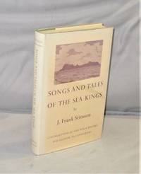
195728122Salem:: Peabody Museum of Salem 1957. First Printing of the First US Edition. a Fine tight copy in a Near Fine dust jacket with a hint of fading to the spine. With the subtitle “Interpretations of the oral literature of Polynesia” this is a book of excellent format in which J. Frank Stimson presents interpretations of several tales and legends and of some ninety chants. Most of the original song and tales were transcribed by him Stimson on the island of Raivavae in the Austral group on several islands of the Tuarnotuan archipelago or upon his beloved Tahiti. Most of the tales and songs selected by Marshall are from the Tuamotuan Islands gathered during the Bishop Museum Tuamotuan Expedition of 1929-1931 on which Stimson served as linguist and I as ethnologist and leader and on the follow-up during the Bishop Museum Mangarevan Expedition of 1934. The value of the material transcribed by Stimson lies in the recording of the sources and the fact that we know when where from whom and under what circumstances each legend chant and genealogy was transcribed. Peabody Museum of Salem, unknown
in-8, 251 pp., illustrations, broché, couv. ill. Bel exemplaire. [WE-1]
Book is in excellent condition with barely discernable wear to covers only. Binding is solid and square, covers have sharp corners, exterior shows no notable blemishes, text/interior is clean and free of marking of any kind. 23 page staple bound book with color covers, b&w drawings and photos providing an intro to the subject. Sections include Wood carving in Polynesia, The evolution of Maori carving, Wood carvers and their tools, The human figure, Spirals, Carved houses, Hei-Tiki.
Austral or Tubuai Islands - Raivavae From a French Government Survey, 1901. London Published at the Admiralty 19th Dec. 1904, under the Superintendence of Captain A. Mostyn Field, Hydrographer. Small corrections: 1923. Autore: Admiralty Charts. Luogo: Austral or Tubuai Islands - Polynesia. Anno: '900. Tecnica: incisione. Dimensioni: 482x652 mm
Borabora Island From a French Government Survey, 1886. London Published at the Admiralty, 7th Oct. 1890, under the Superintendence of Captain W.J.L. Wharton, Hydrographer. Interesting of Borabora Island, one of the Society Island. The map is important to comprehend the development of the island that today is one of the celebrated island of Polynesia. Small corrections: 1926. Autore: Admiralty Charts. Luogo: Borabora Island - Polynesia - Society Islands. Anno: 1886 [1926]. Tecnica: incisione. Dimensioni: 652x483 mm
Hao Island - the Bow Island of Captain Cook, and the La Harpe of M. Bougainville, Capt.n F.W. Beechey. In H.M.S. Blossom, 1825. In the upper right corner of the chart insert of Entrance to Hao Lagoon, By M.r Thomas Elson, Master of H.M.S. Blossom. London Published according to Act of Parliament at the Hydrographical Office of the Admiralty, Mar. 12th 1833. Small corrections: 1931. Autore: Admiralty Charts. Luogo: Hao Island - Tuamotu - Polynesia. Anno: '900. Tecnica: incisione. Dimensioni: 286x387 mm
Islands in the South Pacific Ocean - Easter Island or Rapa Nui From a Chilean Government Chart of 1918. In the left corner of the chart insert of Cook Bay or Hanga Roa From a Chilean Government Chart of 1918. In the right corner of the chart insert of Hutuiti Anchorage From a Chilean Government Chart of 1918. In the right side of the chart insert of Sala y Gomez From a Chilean Government Chart of 1918. London Published at the Admiralty, 20th Jan. 1876, under the Superintendence of Capt. F.J. Evans, Hydrographer. Small corrections. Autore: Admiralty Charts. Luogo: Easter Island Rapa Nui - Polynesia. Anno: 1876 [1924]. Tecnica: incisione. Dimensioni: 459x625 mm
Passes and Anchorages in Tuamotu or Low Archipelago. In the left side of the chart insert of Rarola Pass and Anchorage From the French Government Survey, 1904, Makemo I.N.E. Pass and Anchorages From the French Government Survey, 1874. With additions from the United States Government Survey, 1899. In the upper middle part of the chart insert of Tahanea I. Passes From the French Government Survey, 1902. London Published at the Admiralty 9th July 1907, under the Superintendence of Rear Admiral A. Mostyn Field, Hydrographer.Small corrections: 1920. Folded editorially. Autore: Admiralty Charts. Luogo: Tuamotu Islands - Polynesia - Pacific Ocean. Anno: 1907 [1920]. Tecnica: incisione. Dimensioni: 619x977 mm
Port Phaeton and Approaches From the latest French Government Charts. London Published at the Admiralty, 9th Nov. 1900, under the Superintendence of Rear Admiral Sir W.J.L. Wharton, Hydrographer. Small corrections: 1922. Autore: Admiralty Charts. Luogo: Tahiti - Society Islands - Polynesia. Anno: 1900 [1922]. Tecnica: incisione. Dimensioni: 484x649 mm
Raoul or Sunday I. Surveyed by Capt. H.M. Denham, assisted by Lieut: J. Hutchison, J.W. Smith, Mast. E. Wilds, F. Hixson, & F. Howard Sec. Masters 1854. In the left side of the chart insert of CMacauley I. From a Sketch Survey by the Ass. Surveyor General of New Zealand in 1887, Curtis I. From a Sketch Survey by the Ass. Surveyor General of New Zealand in 1887. London Published at the Admiralty, May 4th 1863, under the Superintendence of R. Adm. Washington, Hydrographer. Small corrections: 1930. Autore: Admiralty Charts. Luogo: New Zealand - Kermadec Group - Polynesia - Pacific Ocean. Anno: 1863 [1930]. Tecnica: incisione. Dimensioni: 471x670 mm
Sketches of Anchorages in the Tuamotu or Low Archipelago chiefly taken from the French Government charts to 1907. In the left side of the chart insert of Lagoon Entrance, Manihi Entrance, Avatoru Entrance, Tiputa Entrance, North passage to Rotoava , Passes into Amanu Atoll From the United States Goverment Chart, 1902, Pakaka Pass From the United States Government Chart, 1902. In the right side of the chart Lagoon Entrance, Amyot Bay, Mururoa Island, Fangahina I. From the United States Government Chart, 1902, Pakaka to Seignelay P.t.London Published at the Admiralty 9th July 1907, under the Superintendence of Rear Admiral A. Mostyn Field, Hydrographer. Small corrections: 1931. Autore: Admiralty Charts. Luogo: Tuamotu Islands - Polynesia - Pacific Ocean. Anno: 1907 [1931]. Tecnica: incisione. Dimensioni: 595x480 mm
Suvarov Islands From Sketch Surveys by Comm.r F.H. Lewin and Lieut. C.V. Marsden, assisted by Lieut. T.F.H. Marriott and Sub.-Lieut. L.F. Royston. H.M.S. "Veronica"1920. The Lagoon Entrance from a Survey by Lieut. A.L. Truscott, assisted by Lieut.ts C.F.L. Watson and J.W. Nash. H.M.S. "Pylades" 1900. In the upper right corner of the chart insert of Lagoon Entrance, from a Survey by Lieut. A.L. Truscott, assisted by Lieut.ts C.F.L. Watson and J.W. Nash. H.M.S. "Pylades" 1900, with additions from a Sketch Survey by Comm.r F.H. Lewin and Lieut. C.V. Marsden, H.M.S. "Veronica"1920. London Published at the Admiralty 2nd May 1922 under the Superintendence of Rear Admiral Fred.k C. Learmonth, Hydrographer. Folded editorially. Autore: Admiralty Charts. Luogo: Suwarrow Island - Polynesia. Anno: 1922. Tecnica: incisione. Dimensioni: 652x989.
Teavarua or Uturoa Harbour From the French Survey 1859. With corrections to 1910. In the left side of the chart insert of Fare Harbour in Huahine Island From the French Survey, 1886. London Republished at the Admiralty March 10th 1869 under the Superintendence of Capt. G.H. Richards Hydrographer. Teavarua Harbour also called Uturoa, near the northern end and on the eastern side of Raiatea, is the port most frequented and one of the best anchorages. The village is the residence of the Queen and the seat of government; it extends a mile along the shore, commercing nearly a mile northward of the pass; and the port is the space between the barrier reef and the fringing reef. (Pacific Islands Pilot, Vol. II, p. 123) It is a very interesting map because it lead to comprehend the development of the area. Small corrections: 1930. Autore: Admiralty Charts. Luogo: Raiatea Island - Society Islands - Polynesia. Anno: 1869 [1930]. Tecnica: incisione. Dimensioni: 609x483 mm
Gallimard 1989, In-4 broché, 255 pages. Superbes photos en couleurs. Trés bon état.
Brescia, 1971, 8vo stralcio con copertina posticcia muta, pp. 97/116 con una cartina, 7 figure e 7 illustrazioni fotografiche. - !! ATTENZIONE !!: Con il termine estratto (o stralcio) intendiamo riferirci ad un fascicolo contenente un articolo, completo in se, sia che esso sia stato stampato a parte utilizzando la stessa composizione sia che provenga direttamente da una rivista. Le pagine sono indicate come "da/a", ad esempio: 229/231 significa che il testo è composto da tre pagine. Quando la rivista di provenienza non viene indicata é perché ci è sconosciuta. - !! ATTENTION !!: : NOT A BOOK : “extract” or “excerpt” means simply a few pages, original nonetheless, printed in a magazine. Pages are indicated as in "from” “to", for example: 229/231 means the text comprises three pages (229, 230 and 231). If the magazine that contained the pages is not mentioned, it is because it is unknown to us.
18512027AG1851. London & New York J & F. Tallis 1851. Original steel engraving / Vintage map. Drawn and engraved by John Rapkin. Partly hand-coloured. Plate Size: 35.7 cm x 25.8 cm. Sheet Size: 37.5 cm x 27.3 cm. Vintage 19th century map in very good condition. John Tallis 7 November 1817 3 June 1876 was an English cartographic publisher. His company John Tallis and Company published views maps and atlases in London from roughly 1838 to 1851. Tallis set up as a publisher with Frederick Tallis in Cripplegate in 1842; the business moved to Smithfield in 1846 and was dissolved in 1849. From 1851 to 1854 Tallis operated as John Tallis and Company. He started The illustrated news of the world and national portrait gallery of eminent personages in 1858 selling it for £1370 in 1861; it folded in 1863. Wikipedia The most important project John Tallis undertook was the 'Illustrated Atlas' from 1851. The original map we offer here was part of this exceptional Atlas and all the maps it contained are still today considered as the last reminder of an era of lavish map production. Tallis worked the project together with John Rapkin 1815-1876 and it was Rapkin's style and talent that we have to thank for when we marvel at these maps today. What makes these maps so special is the detail of engraved vignettes that surround the map and often show indigenous scenes people in their environment and even more so historical buildings or historical views of towns and cities architecture and landscape. The project of 'The Illustrated Atlas' was designed to be finished just in time for the anxiously awaited "Great Exhibition of the Works of Industry of All Nations" or The Great Exhibition sometimes referred to as the Crystal Palace Exhibition in reference to the temporary structure in which it was held was an international exhibition that took place in Hyde Park London from 1 May to 11 October 1851. It was the first in a series of World's Fairs exhibitions of culture and industry that became popular in the 19th century and it was a much anticipated event. The Great Exhibition was organized by Henry Cole and Prince Albert husband of the reigning monarch Queen Victoria. It was attended by numerous notable figures of the time including Charles Darwin Samuel Colt members of the Orléanist Royal Family and the writers Charlotte Brontë Charles Dickens Lewis Carroll George Eliot and Alfred Tennyson. Music for the opening was under the direction of Sir George Thomas Smart and the continuous music from the exhibited organs for the Queen's procession was "under the superintendence of William Sterndale Bennett". Wikipedia unknown
Paris, Horizons de France, 1958. In-8 carré broché, couverture illustrée rempliée de 158 pages. Nombreuses photos en noir, dans et hors texte. Bon état