[New Jersey].Biblio.com
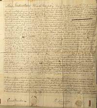
Early Fire Insurance in New Jersey Manuscript Signed One of the first Assessments prepared for the Mount Holly Fire Insurance Company for a home in Borden Town NJ
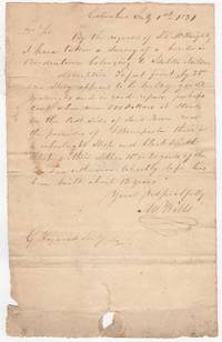
183145385<p>Columbus NJ 1831. Very good folded edge wear & tear light soiling minor fading. 1 pp. 6.5 x 10.5 inches. July 1st 1831 with integral address to G Haywood Secretary of the Mount Holly Fire Insurance Company. Signed survey for the home of Isabella Neilson of Bordentown. The Mount Holly Fire Insurance Company was incorporated in 1831.<br /><br />"By the request of J.L.W. Knight I have taken a Survey of a house in Bordentown belonging to Isabella Neilson. description 30 feet front by 25 one story appears to be built of good materials and in good repair perhaps cost when new 500 Dollars it stands on the East Side of said Town near the premises of Bonnparl their is a wheelwright Shop and black smith within 15 or 20 yards of the house otherwise tolerably safe has been built about 12 years."</p>
Kaaterskill Books, ABAA/ILAB · États-Unis100,00 $US≈ 84,61 €