GAIMARD (Joseph-Paul) & MAYER (Auguste).Livre Rare Book

125 résultats
1842LBW-4934[1842-1856]. 312 x 404 mm.
1855LBW0394fNew York, 1855. 402 x 327 mm.
1820LBW-4474[circa 1820]. 238 x 377 mm.
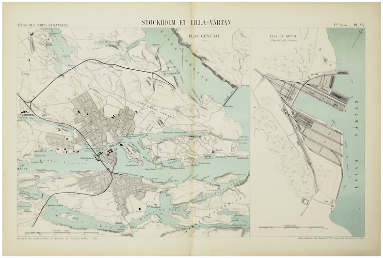
1884LBW-5469Paris, Auto. Marchadier et Cie, 1884. 285 x 459 mm.
1900LBW-8937[vers 1900]. 329 x 422 mm, marges comprises.
1842LBW-4883[1842-1856]. 312 x 400 mm.
1883LBW-5468Paris, Auto. Marchadier et Cie, 1883. 285 x 452 mm.
18071146838Weimar, Landes-Industrie-Comptoir, 1807. 6, 109, (1) S. (Bibl. der neuesten u. wichtigsten Reisebeschreibungen 34). Kart. d. Zeit (gering fleckig, o. d. Reihentitel).
1844R100063898Arthus Bertrand. 1844. In-8. Broché. Etat passable, Plats abîmés, Dos abîmé, Rousseurs. 450+6 pages - papier jauni - tampons sur la page de titre - annotation à l'encre sur la page de faux titre - plats désolidarisés - dos absent, ouvrage désolidarisé - déchirures sur les plats - étiquette collée sur le 1er plat.. . . . Classification Dewey : 948-Scandinavie
1857231345Copenhagen: L'Imprimerie de Thiele 1857. First edition. 22 plates. 10 pp. text. 1 vols. Folio. Contemporary boards. Spine perished boards detached. Internally Fine. First edition. 22 plates. 10 pp. text. 1 vols. Folio. L'Imprimerie de Thiele unknown
1857231345Copenhagen: L'Imprimerie de Thiele 1857. First edition. 22 plates. 10 pp. text. 1 vols. Folio. Contemporary boards. Spine perished boards detached. Internally Fine. First edition. 22 plates. 10 pp. text. 1 vols. Folio. L'Imprimerie de Thiele unknown books
189490706Villefranche, Imprimerie Fontaine, Auray et Guillemin 1894 Grand in-4. Sous chemise carton à lacets, marouflée percaline cachou, report auteurs et titre en lettres argent sur le premier plat, dos muet, 1 volume broché, premier plat de couverture illustré en couleurs, XII-174 pp. et un appendice de 11 pp. notes photographiques, avec de nombreuses photocollographies dans le texte, d'après les procédés spéciaux de la maison Thévoz de Genève. Dos passé, lacets arrachés, intérieur frais.
1829621295Berlin, Reimer, 1829. VIII, 350 S., 1 Bl. Errata. Mit 2 kolorierten gefalteten Kupferkarten, 3 gefalteten lithographierten Tafeln u. 2 Falttabellen. Halbleder d. Zeit mit Rückenschild (leicht berieben, Ecken bestoßen, Einriß im Rücken ausgebessert). [3 Warenabbildungen]
18971307677Christiana (Oslo), Udgiverens Forlag, (etwa 1897). Quer-4to (ca 26,5 : 34 cm). 12 Tafeln (11 in Ton- u. 1 in Chromolithographie: Adolf Tidemand pinx. - Photogr. af Wischmann - Lithogr. af Em. Baerentzen lith. Inst.), 14 Bl. m. Titel, Widmung, Inhalt u. dreispaltigen Texten in Norwegisch, Englisch u. Französisch. Späterer Hlwdbd m. neuen Vorsätzen (Deckel etwas berieben, Blattränder leicht finger- u. braunfleckig, Seidenpapier-"Hemdchen" teilw. eingerissen u. geknickt).
1862123449- Une feuille 23 x 33 cm. Légèrement défraîchie. Taches.
1900644411 Oplag, original full cloth with colour-lithograph on the frontcover, H. Abel's Kunstforlag, Christiana, s.d. [ circa 1900 ], 25 ff.
18271806210648xbvkCopenhagen, Schultz, 1827. (4) 203 pages; 1 engraved wholepage diagramm, 1 engraved plate. - Gilt-titled decorative half-leather binding with colourful marbled panels, all edges black; 8vo.(ca. 19 x 11 cm).
18371306940Kopenhagen, Schubothe, 1834 - 1837. Zus. etwa 1600 S., 2 mehrf. gefaltete Stammtaf. Hldrbde d. Zeit m. reicher Rückenvergoldung (beschabt, Ecken bestoßen, Exlibris, Besitzvermerke, durchgehend braunfleckig, Bd 1 m. 3 S. Notizen a. Vorsatz u. Vorbl., einige Bl. m. kl. Nässerand; Bd. 3 m. handschriftl. Runenalphabet a. Vorbl.)
1892105331892 Paris, Rouam et Cie éditeurs, 1892; in-4°, demi-chagrin bleu roi, dos à nerfs, titre doré, fleuron doré et initiales H.B. entrelacées dorées en pied, couverture illustrée par Laurent-Gsell conservée, non rogné sauf en tête (teintée en bleu); ( 2)ff. faux-titre, frontispice), 252pp. Illustré dans le texte ou à pleine page de bois gravés.
18161311452Greifswald, F. W. Kunike, 1816. Kl.-4to. 2 Bl., S. 9 - 14. Rücken-Broschur.
1876147836Kjobenhavn. Immanuel Rées Forlag. (1876). Ca. 220 n. n. pages. With a lot of illustrations (woodcuts). Half-leather binding. (Parially rubbed. Some pages are repaired). 19x14 cm
1851200100AG1851. London Edinburgh & Dublin J & F. Tallis 1851. Original steel engraving / Vintage map. Drawn and engraved by John Rapkin. Partly hand-coloured. Illustrations by H. Warren and engravings by J.B. Allen. Plate Size: 25 cm x 34 cm. Sheet Size: 27.4 cm x 37.4 cm. Vintage 19th century map in very good condition. Published in the Illustrated Atlas And Modern History Of The World Geographical Political Commercial & Statistical Edited By R. Montgomery Martin. Beautiful and interesting map of Denmark: the Jutland Peninsula and the surrounding islands such as Zealand and Funen in the Baltic and the North Sea. The political subdivisions of Denmark are delineated and the towns and cities including Copenhagen Aarhus and Odense are shown. Off the east coast the Cattegat strait is identified. The southern coast of Sweden is shown as are the German coasts in the lower part of the map Hanover Mecklenburg and Prussia The Danish royal coat-of-arms can be seen in the upper right corner of the map. John Tallis 7 November 1817 3 June 1876 was an English cartographic publisher. His company John Tallis and Company published views maps and atlases in London from roughly 1838 to 1851. Tallis set up as a publisher with Frederick Tallis in Cripplegate in 1842; the business moved to Smithfield in 1846 and was dissolved in 1849. From 1851 to 1854 Tallis operated as John Tallis and Company. He started The illustrated news of the world and national portrait gallery of eminent personages in 1858 selling it for £1370 in 1861; it folded in 1863. Wikipedia The most important project John Tallis undertook was the 'Illustrated Atlas' from 1851. The original map we offer here was part of this exceptional Atlas and all the maps it contained are still today considered as the last reminder of an era of lavish map production. Tallis worked the project together with John Rapkin 1815-1876 and it was Rapkin's style and talent that we have to thank for when we marvel at these maps today. What makes these maps so special is the detail of engraved vignettes that surround the map and often show indigenous scenes people in their environment and even more so historical buildings or historical views of towns and cities architecture and landscape. The project of 'The Illustrated Atlas' was designed to be finished just in time for the anxiously awaited "Great Exhibition of the Works of Industry of All Nations" or The Great Exhibition sometimes referred to as the Crystal Palace Exhibition in reference to the temporary structure in which it was held was an international exhibition that took place in Hyde Park London from 1 May to 11 October 1851. It was the first in a series of World's Fairs exhibitions of culture and industry that became popular in the 19th century and it was a much-anticipated event. The Great Exhibition was organized by Henry Cole and Prince Albert husband of the reigning monarch Queen Victoria. It was attended by numerous notable figures of the time including Charles Darwin Samuel Colt members of the Orléanist Royal Family and the writers Charlotte Brontë Charles Dickens Lewis Carroll George Eliot and Alfred Tennyson. Music for the opening was under the direction of Sir George Thomas Smart and the continuous music from the exhibited organs for the Queen's procession was "under the superintendence of William Sterndale Bennett". Wikipedia unknown
1831879Stralsund, Wilhelm Trinius, 1831. XXXVI, 211 S. Mit 4 lithogr. Tafeln von Fahlcrantz u. 1 lithogr. Porträt als Frontisp. Priv. HLdr. d. Zt. mit RVergold.
18941508149Leipzig, 1894. 7, 1. S. weiß, 70 S., 1 Bl. Br. (Titelbl. angestaubt).
18451264141Leipzig, J. J. Weber, 1845. 4 Bl., 334 S., 1 Bl. u. 4 Bl., 336 S. Hlwdbde d. Zeit m. Rverg. (leicht berieben, Name auf einem Vortitel "Beathe Lobkowitz", Stempel a. d. Titeln, 1 Titel schwach braunrandig, meist etwas, teilw. aber auch etwas stärker braunfleckig).