Denmark, Scott EBiblio.com

619 résultats
2013DADAX1118513088Wiley 2013-01-04. 1. hardcover. New. 6.30x1.25x9.30. Buy with confidence. Excellent Customer Service & Return policy. Wiley hardcover
SONG1119013992Wiley 2015-03-16. Volume 86 ed. hardcover. Used: Good. 6.10x1.20x9.00. Buy with confidence. Excellent Customer Service & Return policy. Wiley hardcover
2008DADAX0231197640Columbia University Press 2020-08-18. hardcover. New. 5.60x1.00x8.60. Buy with confidence. Excellent Customer Service & Return policy. Columbia University Press hardcover
Morten StrangeIn Pristine Condition. unknown
2006x-1573316679Blackwell Pub 2006. Paperback. New. volume 1087 edition. 389 pages. 8.75x5.75x0.75 inches. Blackwell Pub paperback
DADAX1119013992Wiley 2015-03-16. Volume 86 ed. hardcover. New. 6.10x1.20x9.00. Buy with confidence. Excellent Customer Service & Return policy. Wiley hardcover
2011SONG0470889071Wiley 2011-09-06. 1. hardcover. Used: Good. 6.40x1.90x9.10. Buy with confidence. Excellent Customer Service & Return policy. Wiley hardcover
Per Himmelstrup, edIn Pristine Condition. Some copies available at discounted price due to slight damage $24.50. unknown
2014__1118841905John Wiley & Sons Inc 2014. Hardcover. New. 464 pages. 9.50x6.25x1.25 inches. John Wiley & Sons Inc hardcover
2020x-0231197640Columbia Univ Pr 2020. Hardcover. New. 316 pages. 8.50x5.50x1.00 inches. Columbia Univ Pr hardcover
ria9789813234307_inpHardback. New. New Book; Fast Shipping from UK; Not signed; Not First Edition; This book discusses the subject of turbulence encountered in coastal and civil engineering.The primary aim of the book is to describe turbulence processes including transition to turbulence; mean and fluctuating flows in channels/pipes hardcover
a78822Kobenhavn 1789. In Danish. 12mo. 52pp plus Bilager 1-15 later boards with cloth spine and handwritten title label on front. Danish bibliothek stamp crossed out on front pastedown. VG some foxing. Scarce. . hardcover
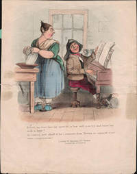
16-6399London: W. Spooner 377 Strand circa 1838-1840. Handcoloured lithograph. 31 x 24.5cm.Sheet size. Centerfold with old repair British Museum:William Kohler: 22 Denmark Street Soho address on prints of 1838-1840 some possibly earlier.William Spooner:Print publisher specialising in lithographs of a semi-popular and humorous character many for children. His activity in the print trade ran from 1831 to 1850 after which he moved onto book publishing.From the collection of Frederic Gale Ruffner Jr. the founder of Gale Research Detroit. .0 London: W. Spooner, 377 Strand, circa 1838-1840 unknown
2013__1118835220John Wiley & Sons Inc 2013. Hardcover. New. volume 83 edition. 552 pages. 9.25x6.25x1.25 inches. John Wiley & Sons Inc hardcover
2013__1118674251John Wiley & Sons Inc 2013. Hardcover. New. volume 81 edition. 584 pages. 9.50x6.25x1.50 inches. John Wiley & Sons Inc hardcover
2013__1118674286John Wiley & Sons Inc 2013. Hardcover. New. volume 82 edition. 672 pages. 9.25x6.50x1.50 inches. John Wiley & Sons Inc hardcover
ria9781836080008_inpMultiple-component retail product. New. New Book; Fast Shipping from UK; Not signed; Not First Edition; FIDIC 2017 Contracts Companion - Revised 3 volume set is a guide for anyone involved in preparing administering or contributing to the FIDIC suite of contracts 2017 edition. unknown
33859527like new. unknown
35096152like new. unknown
1171386like new. unknown
Q-0412614804Routledge. Paperback. New. New. In shrink wrap. Looks like an interesting title! Routledge paperback
1171386-nnew. unknown
1780200039AG1780. Paris De l'Isle et Buache 1780. Original hand-coloured engraving. Plate Size: 64.4 cm x 48.7 cm. Sheet Size: 66.6 cm x 52.7 cm. Original map. In very good condition with the slightest traces of browning only. A very detailed and interesting map of Denmark - the Jutland peninsula and the archipelago of islands such as Funen Zealand and Bornholm- and the and southern Sweden. The Duchies of Brem and Meckelbourg and Pomeranie on the German coast can be seen in the lower part of the map. The cities of Hamburg Copenhagen and Rostock are included on the map. Relief is depicted pictorially. The sand banks and shallows along the coasts are also depicted. Block of annotative French text lies within the Baltic Sea. Guillaume Delisle 1675-1726 was a renowned mapmaker who led the reform of French cartography. A brother of the astronomer Joseph-Nicolas Delisle and a student of the astronomer Jean-Dominique Cassini Delisle learned to fix accurate positions by astronomical observation. The accuracy of his continental outlines and his reduction of gross errors in determining lines of longitude were considerable improvements over earlier maps. His earliest works published in 1700 were a pair of globes terrestrial and celestial maps of the continents and a world map in hemispheres. He prepared about 100 maps and wrote on mensuration and ancient geography. At 27 Delisle was admitted into the French Académie Royale des Sciences an institution financed by the French state. After that date he signed his maps with the title of "Géographe de l'Académie". Five years later he moved to the Quai de l'Horloge in Paris a true publishing hub where his business prospered. In 1718 he was the first to become chief geographer to the king. Encylopedia Britannica unknown
2011__0470638435John Wiley & Sons Inc 2011. Hardcover. New. volume 76 edition. 584 pages. 9.50x6.25x1.50 inches. John Wiley & Sons Inc hardcover