Denmark, Scott EBiblio.com
619 résultats
DADAX111928144XWiley 2016-06-20. 1. hardcover. New. 6.30x2.00x9.30. Buy with confidence. Excellent Customer Service & Return policy. Wiley hardcover
1963mon0003749499Mouton & Co. 1963T. hardcover. Good. 2.2000 9.6000 6.6000. Mouton & Co. hardcover
2019__1119456665John Wiley & Sons Inc 2019. Hardcover. New. 750 pages. 9.25x6.25x1.50 inches. John Wiley & Sons Inc hardcover
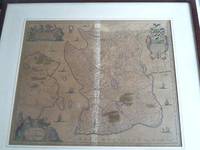
1680200040AG1680. Amsterdam F. de Wit c.1680. Original hand-coloured engraving. Plate Size: 58.1 cm x 48.8 cm. Sheet Size: 63.8 cm x 53 cm. Original map. In very good condition with only the slightest hints of browning to outer margns only. This beautifully engraved chart shows the main Danish islands of Funen and Zealand plus the eastern coastline of the Jutland peninsula and a little of southern Sweden. The major Danish cities like Copenhagen Aarhus and Odense are shown on the map. The map is filled with minute detail of fortresses cities towns and tiny villages. Relief depicted pictorially The lower right corner of the map bears a stunningly decorative cartouche featuring the Danish royal coat-of-arms and a Classical scene of putti and merfolk frolicking in the sea with the god Mercury in the foreground. A small compass rose lies off the Schleswig Holstein coast in the Colberger Heide. Frederick de Wit 1629/1630 1706 was a Dutch cartographer and artist who drew printed and sold maps. By 1648 during the height of the Dutch Golden Age De Wit had moved from Gouda to Amsterdam. As early as 1654 he had opened a printing office and shop under the name "De Drie Crabben" the Three Crabs which was also the name of his house on the Kalverstraat. In 1655 De Wit changed the name of his shop to the "Witte Pascaert" the White Chart. Under this name De Wit and his firm became internationally known. The first cartographic images that De Wit engraved were a plan of Haarlem that has been dated to 1648. The first charts engraved by De Wit were published in 1654 under the "De Drie Crabben" address. The first map that was both engraved and dated by De Wit was that of Denmark: "REGNI DANIÆ Accuratissima delineatio Perfeckte Kaerte van 't CONJNCKRYCK DENEMARCKEN" in 1659. His first world maps "NOVA TOTIUS TERRARUM ORBIS TABULA AUCTORE F. DE WIT" and Nova Totius Terrarum Orbis Tabula appeared around 1660. His Atlas began to appear around 1662 and by 1671 included anywhere from 17 to 151 maps each. In the 1690s he began to use a new title page "Atlas Maior" but continued to use his old title page. His atlas of the Low Countries first published in 1667 was named Nieuw Kaertboeck van de XVII Nederlandse Provinciën and contained 14 to 25 maps. De Wit quickly expanded upon his first small folio atlas which contained mostly maps printed from plates that he had acquired to an atlas with 27 maps engraved by or for him. By 1671 he was publishing a large folio atlas with as many as 100 maps. After Frederick de Wit's death in 1706 his wife Maria continued the business for four years printing and editing De Wit's maps until 1710. However as De Wit's son Franciscus was already a prosperous merchant by this time and had little interest in his father's business he did not take over the publishing house. In 1710 Maria sold the firm at auction. At the auction most of the atlas plates and some of the wall map were sold to Pieter Mortier whose publishing company grew to become one of the largest cartography publishing houses of the 18th century. The 27 chart plates from his 1675 Sea atlas were sold at the 1710 auction to the Amsterdam print seller Luis Renard who published them under his own name in 1715 and then sold them to Rennier and Joshua Ottens who continued to publish them until the mid-1700s. Wikipedia unknown
1999x-185075974XSheffield Academic Pr 1999. Hardcover. New. 1st edition. 272 pages. 9.50x6.25x1.00 inches. Sheffield Academic Pr hardcover
1m5313Janssonius Amsterdam um 1650. Teilcolorierte Karte im Kupferstich mit 3 Kartuschen mit Figurendarstellungen wie Putten sowie einem Wappen. Gesamtgröße 76cm x 655 cm. Größe der Darstellung 546 cm x 453 cm. Unter Passepartout und unter Glas gerahmt Karte gebräunt/in Falz etwas aufgehellt. - Maßstabsangaben in deutschen und französischen Meilen - unknown
T.K. DerryNot in perfect condition. unknown
AdityaBooks-9781118513088Wiley. New. Wiley unknown
AdityaBooks-9781118509418Wiley. New. Wiley unknown
AdityaBooks-9781118513088Wiley. New. Wiley unknown
AdityaBooks-9781118509418Wiley. New. Wiley unknown
1660441AG1660. Amsterdam Blaeu c.1660. Beautifully handcoloured Original Engraving copper engraving with the decorative and pictoresque Cartouches. Beautifully framed. Size of Frame with map: 66.5 cm x 80 cm. Map itself measures: 44 cm x 58 cm. Excellent condition of this beautiful original 18th century map of this area in Denmark. Framed Handcoloured ! Professionally cleaned historical map beautifully and professionally mounted/restored on see-through acid-free paper. Willem Janszoon Blaeu also abbreviated to Willem Jansz. Blaeu was a Dutch cartographer atlas maker and publisher. Blaeu was born at Uitgeest or Alkmaar. As the son of a well-to-do herring salesman he was destined to succeed his father in the trade but his interests lay more in Mathematics and Astronomy. Between 1594 and 1596 as a student of the Danish astronomer Tycho Brahe he qualified as an instrument and globe maker. In 1600 he discovered the second ever variable star now known as P Cygni. Once he returned to Holland he made country maps and world globes and as he possessed his own printing works he was able to regularly produce country maps in an atlas format some of which appeared in the Atlas Novus published in 1635. In 1633 he was appointed map-maker of the East Indian Company. He was also an editor and published works of Willebrord Snell Descartes Adriaan Metius Roemer Visscher Gerhard Johann Vossius Barlaeus Hugo Grotius Vondel and the historian and poet Pieter Corneliszoon Hooft. He died in Amsterdam. He had two sons Johannes and Cornelis Blaeu who continued their father's mapmaking and publishing business after his death in 1638. Prints of the family's works are still sold today. Original maps are rare collector items. The Dutch painter Johannes Vermeer of Delft 1632-1675 holds a position of great honor among map historians. Several of his paintings illustrate maps hanging on walls or globes standing on tables or cabinets. Vermeer painted these cartographical documents with such detail that it is often possible to identify the actual maps. Evidently Vermeer was particularly attached to a Willem Blaeu - Balthasar Florisz van Berckenrode map of Holland and West Friesland as he represented it as a wall decoration in three of his paintings. Though no longer extant the map's existence is known from archival sources and second edition published by Willem Blaeu in 1621 titled "Nova et Accurata Totius Hollandiae Westfriesiaeq. Topographia Descriptore Balthazaro Florentio a Berkenrode Batavo". Vermeer must have had a copy at his disposal or the earlier one published by Van Berckenrode. Around 1658 he showed it as a wall decoration in his painting "Officer and Laughing Girl" which depicts a soldier in a large hat sitting with his back to viewer talking with a smiling girl who holds a glass in her hand. Bright sunlight bathes the girl and the large map on the wall. Vermeer's gift for realism is evidenced by the fact that the wall map mounted on linen and wooden rods is identifiable as Blaeu's 1621 map of Holland and West Friesland. He captures all of its characteristic design decoration and geographic content." His maps formed the bulk of the Atlas Maior that became a collector's item in Amsterdam. One of Blaeu's globes was purchased at auction by Maarten Magielse a Dutch salesman for the record price of 60.000 euro about $80.000. Magielse is now renting it to the globe museum in Vienna where it is being exhibited. Wikipedia unknown
2002x-1841273147Sheffield Academic Pr 2002. Hardcover. New. 1st edition. 242 pages. 9.25x6.25x0.75 inches. Sheffield Academic Pr hardcover
2019x-1119456622John Wiley & Sons Inc 2019. Hardcover. New. 750 pages. 9.25x6.25x1.00 inches. John Wiley & Sons Inc hardcover
1993x-0415087600Routledge 1993. Hardcover. New. 1st edition. 335 pages. 9.75x6.50x1.00 inches. Routledge hardcover
Abrahamowitz, FinnIn Pristine Condition. unknown
2019__1119374545John Wiley & Sons Inc 2019. Hardcover. New. 750 pages. 9.20x6.40x1.50 inches. John Wiley & Sons Inc hardcover
2016__1119211212John Wiley & Sons Inc 2016. Hardcover. New. 1st edition. 1360 pages. 9.00x6.50x2.50 inches. John Wiley & Sons Inc hardcover
2017__1119281415John Wiley & Sons Inc 2017. Hardcover. New. 726 pages. 9.25x6.25x1.75 inches. John Wiley & Sons Inc hardcover
2018__1119308933John Wiley & Sons Inc 2018. Hardcover. New. 800 pages. 9.00x6.00x1.25 inches. John Wiley & Sons Inc hardcover
2004x-0205404561Allyn & Bacon 2004. Paperback. New. 2nd edition. 588 pages. 9.00x7.00x1.00 inches. Allyn & Bacon paperback
2018__1119374537Wiley 2018. Hardcover. New. 633 pages. 9.00x6.00x1.25 inches. Wiley hardcover
2019__1119456584John Wiley & Sons Inc 2019. Hardcover. New. 750 pages. 9.25x6.25x1.50 inches. John Wiley & Sons Inc hardcover
2018__1119308925John Wiley & Sons Inc 2018. Hardcover. New. 635 pages. 9.00x6.00x1.50 inches. John Wiley & Sons Inc hardcover
178956256Hamburg 1789. With four folding charts in vol. I. Pp.2 xxx 14 contents 578; xii 2 contents 556. 2 vols. 8vo. Contemporary quarter calf and boards. Rubbed. About very good. With four folding charts in vol. I. Pp.2 xxx 14 contents 578; xii 2 contents 556. 2 vols. 8vo. First and only edition of this important documentary source publishing letters and papers of Frederick IV of Denmark Queen Anna Sophia of Dänemark correspondence with the King of Prussia as well as texts concerning Copenhagen the judiciary police and city council changes in the Danish language etc.<br /> <br /> A further continuation volume appeared in 1790. unknown