Antiquariat.de
Tuzla.
Tuzla, J. Petrovic [ca. 1914]. Farb. Karte. 9 x 14 cm. Knickspuren.
1 592 résultats
Tuzla, J. Petrovic [ca. 1914]. Farb. Karte. 9 x 14 cm. Knickspuren.
Fine English Paperback. Pbo. Roy. 8vo. (24 x 17 cm). Title in English, French, German, and Arabic; text in Turkish. 10 p. Turkish newspapers and journals publishes in Bulgaria.= Die türkischen Zeitungen und Zeitschriften die in Bulgarien herausgegeben werden.= Journaux et revues Turcs parus en Bulgare.
New English Paperback. Pbo. Roy. 8vo. (24 x 17 cm). In English. 290 p. Articles in Italian, German, French and English. Main contents: Multicultural and Multilingual Istanbul; Language Contacts in South-Eastern Europe from the late 18th to the early 20th centuries; The Influence of Turkish on the modern Balkan languages.
As New English Paperback. Pbo. Mint. Roy. 8vo. (24 x 17 cm). 3 volumes set: (819 p.; [cLxxxii], 832 p.; 779 p.). Turkish emigrations from the Balkans. Documents.= Emigrations Turques des Balkans. Documents.= Rumeli'den Türk göçleri. Belgeler. 3 volumes set.
Very Good English Paperback. Pbo. Roy. 8vo. (23 x 6 cm). In English. 50 p. Turkish - Greek relations and the Balkans. A historian's evaluation of today's problems.
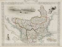
1851200055AG1851. London and New York J & F. Tallis 1851. Original steel engraving / Vintage map. Drawn and engraved by John Rapkin. Partly hand-coloured. Illustrations by H. Warren and engraved by J. Rogers. Plate Size: 32.5 cm x 26 cm. Sheet Size : 37.4 cm x 27.3 cm. Vintage 19th century map in very good condition. Published in the Illustrated Atlas And Modern History Of The World Geographical Political Commercial & Statistical Edited By R. Montgomery Martin. Beautiful and interesting map of South East Europe. Much of the Balkans was then under the control of the Ottoman Turks. The region is delineated into the historic - and future - nations and states including Croatia Herzegovina Bosnia Serbia Albania Macedonia northern Greece Bulgaria Walachia in Romania and Moldova. Russia can be seen extending down into the areas around the Black Sea. Hapsburg-Austria and the heel of the Italian peninsula is shown. Corfu Cyprus and the Greek islands can be seen lying of the archipelago. Gallipoli Sea of Marmara the Bosporus and Constantinople/Istanbul and Asia Minor/Anatolia are shown in the lower right corner. John Tallis 7 November 1817 3 June 1876 was an English cartographic publisher. His company John Tallis and Company published views maps and atlases in London from roughly 1838 to 1851. Tallis set up as a publisher with Frederick Tallis in Cripplegate in 1842; the business moved to Smithfield in 1846 and was dissolved in 1849. From 1851 to 1854 Tallis operated as John Tallis and Company. He started The illustrated news of the world and national portrait gallery of eminent personages in 1858 selling it for £1370 in 1861; it folded in 1863. Wikipedia The most important project John Tallis undertook was the 'Illustrated Atlas' from 1851. The original map we offer here was part of this exceptional Atlas and all the maps it contained are still today considered as the last reminder of an era of lavish map production. Tallis worked the project together with John Rapkin 1815-1876 and it was Rapkin's style and talent that we have to thank for when we marvel at these maps today. What makes these maps so special is the detail of engraved vignettes that surround the map and often show indigenous scenes people in their environment and even more so historical buildings or historical views of towns and cities architecture and landscape. The project of 'The Illustrated Atlas' was designed to be finished just in time for the anxiously awaited "Great Exhibition of the Works of Industry of All Nations" or The Great Exhibition sometimes referred to as the Crystal Palace Exhibition in reference to the temporary structure in which it was held was an international exhibition that took place in Hyde Park London from 1 May to 11 October 1851. It was the first in a series of World's Fairs exhibitions of culture and industry that became popular in the 19th century and it was a much-anticipated event. The Great Exhibition was organized by Henry Cole and Prince Albert husband of the reigning monarch Queen Victoria. It was attended by numerous notable figures of the time including Charles Darwin Samuel Colt members of the Orléanist Royal Family and the writers Charlotte Brontë Charles Dickens Lewis Carroll George Eliot and Alfred Tennyson. Music for the opening was under the direction of Sir George Thomas Smart and the continuous music from the exhibited organs for the Queen's procession was "under the superintendence of William Sterndale Bennett". Wikipedia unknown
199434859(Stuttgart, Radius, 1994). 93 S., 1 Bl. 8° (20,5 x 12,5 cm). Original-Karton.
RO30007549Git le coeur. non daté. In-18. Broché. Bon état, Couv. convenable, Dos satisfaisant, Intérieur frais. 143 pages.. . . . Classification Dewey : 949.6-Balkans
1956246965Gütersloh : Bertelsmann, 1956. 463 S. ; 8 Originalleinen mit Original-Schutzumschlag.
19102631-21Trebinje, Alekovic [ca. 1910]. Farblith. Karte. 8, 7 x 14 cm. In gutem Zustand. [2 Warenabbildungen]
19952711809210ybvkMünchen, Cormoran-Verlag, 1995. 212 Seiten, durchgehend farbig bebildert und mit 16 geographischen Karten; Fester, farbig illustrierter Originaleinband mit Deckel- und Rückentitel; Folio (ca. 34 x 22 x 2 cm; ca. 1,7 kg.).
78160aafGeneve, Kundig, 1944, gr. in-8vo, 154 p., ill. on plates (colored maps) + large folded map, original wrappers.
19633720Belgrad, (Slobodan Jovic), 1963. 104 S., 1 Bl. 1 mehrf. gefalt. Karte 8°. OKart. (Gebrssprn., etw. fleckig).
Very Good Turkish Original illustrated cloth bdg. Cr. 8vo. (20 x 14 cm). In Turkish. 3 volumes set: (476, [2] p.; 539 p.; 511, [1] p.), b/w portraits. 3 volumes set: Vol. 1: Köraga Sokagi (Anlati). Vol. 2: Ak yüzün simgeleri (Siirler). Vol. 3: Günesin gözlükleri (Çocuklara siirler). All works of Mercan.
201113691Kiepenheuer&Witsch, Köln, 2011. 263(1) Seiten, OPappband m. OU, von Altaras voll signiert. Signed by the author. Privater Name aV. Good copy. First german edition.
1980K781Zürich, Orell Füssli, 1980. Erste deutsche Ausgabe. Schönes Exemplar.
1944R2611-94Lpz.,Meiner (1944). kl.4°. XV,127 S. Mit 8 farb. u. 8 schw.-w. Bildtaf. Illustr. Obrosch., leicht bestoßen u. angestaubt, sonst in gutem Zustand. - Schriftenreihe der Deutsch-Bulgarischen Gesellschaft e.V. Bd.3
19941219395PN. New. 1994. Reprint Edition. Soft Cover. Date is copyright date; this is a later reprint edition . PN paperback
1994271150PN. New. 1994. Soft Cover. Date is original print. This is a reprint edition . PN paperback
6207842316.Gpaperback. Good. Access codes and supplements are not guaranteed with used items. May be an ex-library book. paperback
ria9786207842315_inpPaperback. New. New Book; Fast Shipping from UK; Not signed; Not First Edition; Of a special interest are tilings in hyperbolic n-space. The present work studies tilings in hyperbolic n-space of arbitrary dimension by polytopes. The best behaved tilings are the face-to-face tilings by convex polytopes. The main res paperback
B9786207842315Paperback / softback. New. paperback
64696, Brepols, 2022 Paperback, 302 pages, Size:156 x 234 mm, Illustrations:4 maps b/w, Language: English. ISBN 9782503593722.
197622846Leipzig, Verlag E. A. Seemann, 1976. 4°; 366 Seiten, 354 Abbildungen; Orig.-Leinen mit Orig. Folienumschlag (im Schutzkarton) Umschlag randrissig, Folierung an den Rändern teils gelöst, Pappkarton gebräunt und eingerissen
198419315Leipzig ; Jena ; Berlin : Urania-Verlag, 1984. 268 S. : zahlr. Ill. (z.T. farb.), Kt. Gr. 8°. 1. Aufl., 1. - 20. Tsd. OLwd mit SU.