GARZONI Pietro (1645-1735).MareMagnum

116 résultats
Venezia, Appresso Gio. Manfrè, 1717, in-4, piena pergamena floscia coeva, titolo calligrafato al dorso, pp. (8), 673, (43). Bella marca tipografica incisa al frontespizio (fenice che risorge dalle fiamme inquadrata fra 2 cornucopie, motto: "post fata resurgo"), 17 eleganti testate inc. in rame da Abbiati ed Antenore Luciani, capilettera e finali xilografici. Dedicatoria al doge Cornaro ed al Consiglio dei dieci, che permise la pubblicazione della 1ª parte dell'opera ("In tempo della Sacra Lega contro Maometto IV e 3 suoi successori, Gran Sultani de' Turchi": sulla guerra di Morea contro i Turchi) con decreto liberatorio, nel 1705. Pubblico storiografo della Repubblica dal 1692 e per ben 25 anni, Garzoni dovette attendere fino al 1717 per pubblicare questa 2ª parte, che si arresta prima del 1714, colla perdita della Morea da parte di Venezia. Ottimo esemplare.
"Comprised in twenty-six maps showing the various divisions of the world as known to the ancients composed from the most authentic sources with an index of the ancient and modern names." - from title page. Includes the following maps: Orbis Veteribus Notus; Roma; Italia Meridionalis; Athenae; Peloponnesus et Attica; Graecia Septentrionalis; Insuleae Maris Aeg Aei; Macedonia, Thracia, Illyria, Moesia, et Dacia; Britannia; Insuleae Britannicae; Gallia; Germania; Vindelicia, Noricum, Rhaetia, Pannonia, et Illyricum; Hispania; Africa Septentrionalis; Aegyptus; Asia Minor; Palaestina; Syria; Armenia, Mesopotamia, Assyria, et Babylonia; Arabia; Imperium Persicum; Indiae. Fold-out map entitled 'Central Italy with the Adjacent Countries from the Peutingerian Tables, constructed about A.D. 393'. Extensive 44-page index of place names. Hand done colour outlines to most maps. Average external wear. 1.5" opening to upper corner of front free endpaper. Toning to endpapers. Gilt titling clearly legible upon backstrip. Binding sound. A quality copy of this wonderful reference. Book
8vo., Second Impression, with frontispiece, 26 plates and a full-page map, small neat inscription on front free endpaper; decorative red cloth gilt, gilt back, fore-edges lightly dust-soiled else a very good, bright, clean copy in price-clipped dustwrapper, the latter very lightly age-soiled and rubbed at extremities. Published in the same month as the first edition. SCARCE IN ANYTHING LIKE THIS CONDITION.
8vo., First Edition, with frontispiece, 26 plates and full-page map; handsomely bound in full dark red crushed morocco, sides with gilt frame border, back with raised bands, second and fourth compartments ruled and lettered in gilt, all other compartments tooled in gilt, gilt top, hand-made endpapers, ribbon marker, gilt from upper board and backstrip mounted on new and separate leaves at front, a most attractive copy ideal as a gift or for presentation. An elegant copy of Fermor's classic account of his travels in the Southern Peloponnese.
8vo., First Edition thus, with frontispiece, 26 plates and full-page map; red cloth, upper board blocked in gilt, gilt back, a near fine copy in price-clipped, very lightly browned dustwrapper, the latter chafed at head and tail of backstrip. With personal armorial bookplate on front paste-down. Published simultaneously with the first edition. SCARCE IN THIS CONDITION.
8vo., First Edition, with decorative endpapers; black cloth, backstrip lettered in silver, a near fine copy in dustwrapper. The long-awaited third volume of Fermor's masterly trilogy, narrating his journey from the Hook of Holland to Constantinole in the early 1930s. Fermor was working on the text until his death, and they appear here edited by his literary executors.
192920616Athènes, chez l’auteur, imprimerie Lahure Paris, 1929, e.o. numérotée sur vergé anglais. Broché, couverture rempliée, bien complet de la jaquette, 23 cm x 28,5 cm, 181 pages, 28 planches hors-texte sous serpente dont 7 aquarelles en couleur et photographies sépia en héliogravure, dessins in-texte, 1 carte hors-texte. Texte, illustrations in et hors-texte et photographies de F. Perilla, bibliographie. Légers accrocs sur la jaquette sinon bon état. Voyage en Grèce continentale et dans le Péloponnèse à l’époque des Francs, du Moyen-Age et de Byzance
New English Original bdg. HC. 4to. (31 x 22 cm). In English. 544 p., ills. Ottoman Chrysochou (Mid-19th century). This volume presents the thirteen 19th-century fiscal censuses of the district of Hrisofi (Chrysochou) on the north-western side of Cyprus and joins the other two editions containing the censuses of the neighbouring kazas of Kouklia and Paphos released in 2015 and 2016 respectively. It covers the period from 1825 to 1848. The sources, although concerning taxation, trace the demographic and social status of the population in the mid-19th century, providing opportunities for further comparisons with sources of this type, both older and newer. Research fields can therefore be extended to other periods too, and can be directed at exploring issues that explain conversions to Islam, population movements, etc. The fiscal registers we examined reveal the picture that emerges from official administrative data of the Ottoman Empire, a picture that is no different from that described by Western travellers who visited the island, inspired by an interest in its glorious past in antiquity.
New English Paperback. Roy. 8vo. (24 x 17 cm). In English. 264 p. Population and agricultural production in Ottoman Morea. Preface Settlements and Population in the Morea (1645) Kythera under the Ottomans (1715-1718) Evliya Çelebi on Viticulture and the Wines of the Peloponnese and Crete The Testimony of the Ottoman Tax Registers on Viticulture and Wine-production in the Peloponnese (15th-18th c.) Megaris and the History of Viticulture in the Region (16th-18th c.) Viticulture in the Kaza of Tripolitsa (16th-18th c.) Olive Cultivation in the Ottoman Peloponnese Bibliography Index.
239p. plates.map.bibliography.index Book
Compact but comprehensive and well illustrated tourist guide to the sites of ancient Corinth and objects in the Museum Undated (c 1975 ?)26p. text +56p.plates,diagrams.maps Book
Compact but comprehensive and well illustrated tourist guide to the sites of ancient Corinth and objects in the Museum [ c.1975 ] )26p. text+56p.plates,diagrams.maps Book
1992LFA-126744641Un ouvrage de 246 pages, format 115 x 220 mm, illustré, broché couverture couleurs, publié en 1992, Guides Visa - Hachette, bon état
Portfolio containing documents outlining a proposed housing/ holiday home development called Arkadiko Chorio on the east coast of Arcadia in the Peloponnese, Brochure [16p.] diagrams plans. maps. Brochure
2023x-3031245970Palgrave Macmillan 2023. Hardcover. New. 150 pages. 8.50x6.00x0.50 inches. Palgrave Macmillan hardcover
2000mon0003993450Palgrave Macmillan 3/1/2023 12:00:01 AM. hardcover. Good. 0.6299 8.5433 6.1417. Palgrave Macmillan hardcover
1881T114438Berlin, Weidmannsche Buchhandlung 1881 176pp., original 1881-edition, 24cm., original softcover, pages are still uncut, text is clean and bright, good condition, T114438
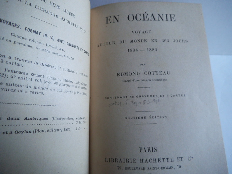
9942Voyage autour du monde en 360 jours 1884-1885 Mention de deuxième édition. In12 demi-chagrin vert foncé à nerfs, titre, fers dorés, filets à froid charnière intérieure toile verte. Faux-titre,frontispice,titre,390 pages,48 gravures hors-texte,4 cartes dont une dépliante.Paris Hachette & Cie 1895.Bornéo-Sarawas, Krakatau, volcans de Java, Australie, Queensland, de Sydney à Melbourne, Tasmanie, Npuvelle Calédonie, Nouvelles Hébrides, Tahiti, Morea, à travers le pacifique, Californie et Mexique, de Mexico à St Nazaire.Bornéo-Sarawas, Krakatau, volcans de Java, Australie, Queensland, de Sydney à Melbourne, Tasmanie, Npuvelle Calédonie, Nouvelles Hébrides, Tahiti, Morea, à travers le pacifique, Californie et Mexique, de Mexico à St Nazaire. Bornéo-Sarawas, Krakatau, volcans de Java, Australie, Queensland, de Sydney à Melbourne, Tasmanie, Nouvelle Calédonie, Nouvelles Hébrides, Tahiti, Morea, à travers le pacifique, Californie et Mexique, de Mexico à St Nazaire.
168649367Venezia 1686. 8vo. 165x11 cm. Contemp. full vellum. Halftitle-page. Engraved Title-page the Lion of St. Mark. 82371 blank2- Indice pp. and 41 of 42 double-page folded engraved maps and plans bird's-eye views or plans of fortified towns and places etc. Internally fine and clean. Printed on good paper. A fine copy. <br/><br/><em>Second edition the first 8vo-edition issued the same year as the first in folio describing the Venetian campaign for the reconquest of the Peloponnese or Morea from which Venice had been almost completely excluded since the Turkish conquest of the Greek island in 1458."As is often the case with Coronelli's work the contents may vary with each example as plates were added subtracted or changed as the editor saw fit" Rodney Shirley "Maps in the Atlases of the british Library" T.Coro-1a - listing only 39 maps and views for this copy.Coronelli Vincenzo Maria an Italian geographer and draughtsman was born at Venice about 1650. From 1681-1683 he worked in Paris on a pair of 3.85 meter diameter globes for Louis XIV which are now in the National Library in Paris. On his return to Venice he was made cosmographer of the Republic and founded the Academy of Argonauts the first Geographical Society. In 1702 he became general of his order. </em> hardcover
Comprehensive, illustrated survey of the major archeological sites in southern Grece. 217p. platues, diagrams.maps.bibliography.index. Book
341p. map bibliography,index. Exceptionally neat, crisp copy, ffep missing else fine. Book
23971Ecole Française d'Athènes/Paris, Librairie Philosophique J. Vrin, 1963. 23 x 28, 81 pp., 20 planches en N/B, 23 figures, broché, non coupé, très bon état.
Athènes 1982. In-4 broché de 208 pages illustrées + cartes. Très bon état
Carta geografica della Morea, il bella e particolare coloritura coeva. Inserita in "Mercurio geografico overo Guida Geografica in tutte le parti del Mondo conforme le Tavole Geografiche del Sansone Baudran de Cantelli Data in luce con direttione, e cura di Gio. Giacomo de Rossi nella sua stamperia in Roma alla Pace all'insegna di Parigi con Priu: del S. Pont" edita a Roma alla fine del '600. Restauri nella parte centrale ed al margine in basso
2005100150833LES BELLES LETTRES 2005 362 pages 13 4x2 2x20 2cm. 2005. Broché. 362 pages.