Dhamo, Dhorka und Refik Veseli (Illus.)Antiquariat.de

9 résultats
19742144031Tirana: Shtepia Botuese '8 Nentori' 1974. 63 Seiten. Mit zahlreichen Abbildungen. Quer-Gr. 8° (22,5-25 cm) Orig.-Broschur. [Softcover / Paperback].
1933MILI0382Roma, Novissima (1933). gr.-8°, 16 S., klammergeh., OKart., außen und innen an den Rändern leicht verschmutzt.
1973HC10-797New York, Dodd, Mead, 1973. original cloth large 8vo, xv, 238 pages with maps and illustrations, copy signed by the author, a good copy
19831610041371xbvkTokyo, Showa 57 (1983). 114 unnumbered pages on glossy paper, photographically illustrated throughout. - Publisher's grey softcover with Dustjacket; 4to.(ca. 29 x 21 cm).
1976GC10-470Thessaloniki, Inst. for Balkan Studies, 1976. original cloth binding, gr.-8?, 151 pages, Includes index ; a very good copy
1914A111-097Wien, Kaiserlich-K?nigliches Milit?r-Geographisches Institut, 1914. Hochformat, ca. 42 x 55 cm, Ausgabe: mehrf?rbig; Zustand: gut +
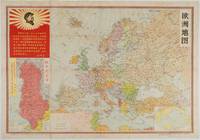
1968223179Beijing.: 地图出版社.Ditu chubanshe. First Impression. 1968. Coloured political map of Europe with inset key scale 1:10000000 the two inset maps show the location of Europe in the world and a large inset map of Albania with a separate inset key scale of 1:1 200000. Inset image illustration of Mao Zedong with a long quote. Text in simplified Chinese characters 53.6cm x 77.2cm. Some browning and foxing small holes at fold points a number of folds skillfully repaired with washi on the reverse a bright copy of a scarce map. OCLC shows only one copy held in Hangzhou Public Library and none outside China. An interesting map featuring Albania the only state to align with China rather than with the USSR during the Sino-Soviet split. In an echo of the quote by Mao about how the masses will always oppose revisionism Albania denounced Soviet revisionism. The alliance with China provided Albania with economic and political backing and provided China with a strategic ideological foothold in Europe as the Soviet bloc slowly fragmented. It is interesting to note that the inset map of Albania includes a sea lane marking noting the distance between Guangzhou and Durres on the coast of Albania. . 地图出版社.[Ditu chubanshe]. unknown
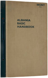
194321161951943. London: Box 99 Western Central District Office New Oxford Street W.C.1 August 1943 - January 1944. Five parts within printed card wrappers in Navy shoestring-bound original cloth folder with lettering on front cover; highly illustrated with folding maps charts and diagrams; near-fine.Extremely rare top secret publication. The first part gives information on Albania 'pre-invasion'; the second part outlines the country 'post-invasion' issued in August 1943. The third part is the Map Section which is followed by two supplements the last of which with the sub-title Political and Local Directory. All we were able to find out about this perfectly disguised publisher is that they used the same street address as for the Who's Who in Nazi Germany. In June 1940 the newly created British Special Operations Executive SOE was given the task of encouraging resistance movements in Italian-occupied areas. Albania was of foremost interest because of its geostrategic position and large sometimes militant resistance against the Italian occupants. One of the most eminent local resistance leaders and SOE allies was Major Abaz Kupi. The autobiography of Julian Amery an operative on the Balkans and in AlbaniaApproach March 1973 might shed more light on these operations which led to the liberation of Albania. Library Hub locates five parts at LSE four parts in the British Library and three parts only at Oxford. hardcover