8 résultats
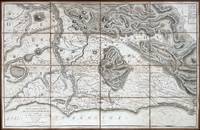
161860225Rome: Venance Monaldini Librarie Place d’Espagne No. 79 1816-1821. Four works. 1st -- Large dissected copper-engraved map dissected & mounted on linen 35.5 x 22.75 in. slight foxing edgewear closed tears at corner folds a couple folds w/ archival repair tape on verso over linen; 2nd & 3rd - 8vo. 63 1; 15 1 pp. With large folding copper-engraved frontisp. highlighting section of the pantogram. Original marbled wrappers very slight chipping head & foot of spine; 4th -- large 3-sheet “Pantogram†or panoramic view of Rome 63 x 8.75 in. all preserved together in open-backed slipcase wrapped in patterned blue paper printed cover label manuscript pricing information & title in ink some scuffing & edgewear still an overall VG set. Second edition of the large dissected map of Rome and surrounding countryside fourth edition of the two-in-one handbook illustrating the coast along the Tyrrhenian Sea from Lake Bracchiano to Mount Circe and inland to the Central Apennines foothills. Sickler’s 1773-1836 Panoramic elevated view of Rome with text key above identifying churches monuments and historical locations in 19th-Century Rome together with the map and handbooks here were key references for those taking the Grand Tour following the Napoleonic Wars which had devastated much of the Continent. Pietro Ruga 1772-1850 was a noted Italian engraver printmaker furniture designer and architectural draftsman best remembered for his maps and pocket panoramic views of Rome. Venance Monaldini Librarie, Place d’Espagne, No. 79, unknown
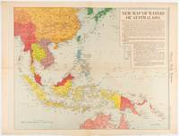
1619180757Chicago.: Chicago Daily Tribune. December 161942. Printed colour map on a single newspaper leaf 41.6 x 52.8 cm; 45 x 60 cm sheet inset legends marginal browning and at the folds but remarkably bright in very good condition. Map of Southeast Asia published in the Chicago Daily Tribune "The World's Greatest Newspaper" delineating the Pacific theatre of war with a detailed text legend. "This is a new war map of the far east showing an important part of southeastern Asia and Australasian waters from a station in which according to Prime Minister Curtin of Australia a United States fleet will operate." Interestingly New Guinea is marked as British rather than as an Australian administrative region which it became following the Treaty of Versailles. <br> <br>"… the historic Chicago Tribune was an innovator in color inks and printing but also a pioneer in bringing colorful art in the form of illustrations photographs cartoons and advertisements to the average person in an everyday medium." see The Janet A. Ginsburg Chicago Tribune Collection Michigan State University Libraries. . Chicago Daily Tribune. unknown
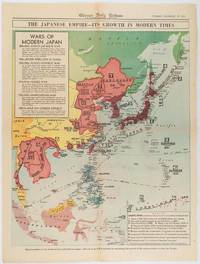
1619180755Chicago.: Chicago Daily Tribune. December 161941. Printed colour map on a single newspaper leaf 50 x 41.5 cm; 60 x 45 cm sheet two inset legends marginal browning and at the folds but remarkably bright in very good condition. Map of the Japanese Empire published in the Chicago Daily Tribune "The World's Greatest Newspaper" on December 16th 1941 9 days after the bombing of Pearl Harbour. The two legends list the "Wars of Modern Japan" from 1894 with territorial gains marked noting that "Each seizure of mainland areas has given Japan new field of raw materials." <br> <br>"… the historic Chicago Tribune was an innovator in color inks and printing but also a pioneer in bringing colorful art in the form of illustrations photographs cartoons and advertisements to the average person in an everyday medium." see The Janet A. Ginsburg Chicago Tribune Collection Michigan State University Libraries. . Chicago Daily Tribune. unknown
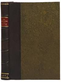
16642341508London: Excudebat J.F. James Flesher pro Jona Hart 1664. First Thus. Hard Cover. Near Fine/No Jacket. Rebound with new end sheets: brown leather spine marbled paper over boards red morocco spine label gilt titles and rules. Binding tight pages clean and unmarked. 1664 Hard Cover. viii 230 pp. Last text page misnumbered 216. Descartes's fundamental and originating work of the modern era in Western philosophy bound together with a work by one of the Utrecht Cartesians Lambert van Velthuysen. This is the first British printing of the Meditations though it does not include Descartes's 'Objections and Replies' as many editions do. Velthuysen was connected by marriage to Descartes's friend Henry Regnier and corresponded with scientists and philosophers such as von Leeuenhoek Spinoza and Leibniz. The work included here shows the influence of Thomas Hobbes - unsurprising given that Velthuysen is credited with translating Leviathan into Dutch. John Locke may have met Velthuysen while in Utrecht in 1684/85 and had eight titles by Velthuysen in his personal library including the Rheims edition of the present title. Bound into this volume are two plates not called for in either work which may be taken from the Hart printing of Principia Philosophia which was published the same year. Wolf 736 Wing D1133a. Excudebat J.F. [James Flesher] pro Jona Hart hardcover
1692Alibris.0018045Francofurti Ad Moenum: Frederici Knochii 1692. Ultima editio cum optimis colla. Full leather. Good. No dust jacket as issued. . Good. Scarce edition. Worldcat locates only 1 copy. Spine well worn and chipped. Moderate foxing throughout Includes: illustrations diagrams. On the rear endpaper is an Armorial bookplate of the Princes of Liechtenstein "Ex Libris Liechtensteinianis" above arms with chain of the Order of the Golden Fleece associated with Prince Franz Joseph II 1906-1989. Frederici Knochii hardcover
16876047<p>Das von den Türcken lang-gequälte nun durch die Christen neu-bescelte Königreich Hungarn Theodoro Tscherning; maps by Martin Stier. Published by Martin Endter Nuremberg 1687. First Edition. 16mo up to 6½" tall. 464pp. fold out dedication to the Holy Roman Emperor Leopold I dated 1687 with detailed engraving of a double-headed eagle holding a scepter and orb; 12 folding maps as called for; index 12pp. Individual maps removed and placed together form one large map. Half leather over marbled boards banded spine red edges. Browning to title page and light toning thereafter. Maps are in very good to fine condition. Partial split to leather at outer upper hinge and partial crack to inner hinge. In very good condition.</p><p>The Kingdom of Hungary long tormented by the Turks now blessed by the Christians. According to the attached XII most accurate maps clearly handled and provided with the newest most remarkable events extending up to the present time. A brief presentation and description of the Hungarian cities fortresses and castles including the neighboring lands of Austria Moravia Carinthia Carniola Styria Bosnia Dalmatia Croatia Slavonia Bulgaria Transylvania etc.</p><p>Published during a pivotal era for the Habsburgs shortly after the 1683 Battle of Vienna and the same year 1687 as the Battle of Mohács which helped solidify Habsburg control over Hungary.</p> Martin Endter hardcover
168424285Edo Tokyo: Hyoshiya Ichirobe Hayashi-shi Yoshinaga First month 1684 But Third month 1680. A large woodcut map of Edo Tokyo with fine handcolouring on joined and folded paper. The map is breathtaking in its detail and features many paintings of important landmarks temples bridges and people who are often pictured working or fishing from boats on the waterways running through Tokyo. A stunning and very rare woodblock map beautifully and unusually handcoloured. Roads blocks buildings open areas canals and waterways are all vividly laid out on this huge and most impressive map. 123.5 by 149.5 cm. folded within paper covers folds to 28 by 18 cm now preserved in a fine clamshell box. A remarkably well preserved and very rare item with some light rubbing due to age and as to be expected. A bit of old worming or light soiling and occasional small repairs but in all quite astonishing in its quality and beautifully preserved with bright and vivid colour and detail. AN EXTRAORDINARY ITEM REMARKABLE FOR BOTH ITS CARTOGRAPHIC DETAIL AND ITS ARTISTIC BEAUTY. The wood block printing shows land tenures of Daimyo and Hatamoto. It also shows temples and shrines includes a distance chart and descriptive listing of Daimyo showing crests and halberds. There is also a inset of the eastern portion of Edo. Hyoshiya Ichirobe (Hayashi-shi Yoshinaga) unknown
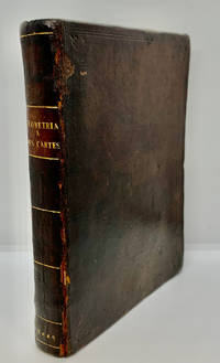
16491000378<p>Geometria à Renato Des Cartes Anno 1637 Gallicè edita; nunc autem Cum Notis Florimondi de Beaune In Curiâ Blaesensi Consiliarii Regii In linguam Latinam versa & commentariis illustrata Operá atque studio Francisci à Schooten Leydensis in Academiâ Lugduno-Batavâ Matheseos Professoris Belgicè docentis. Lugduni Batavorum Leiden: Ex Officinâ Ioannis Maire 1649. First separate and first Latin edition of "La Géometrie". 18th-century leather binding with spine lettering wear to corners and ends but binding is firm. Occasional foxing. The previous owner was John Fitzwilliam died 1699 who was elected fellow of Magdalen in 1661 and became the librarian there in 1662. He would become tutor to Lady Rachel Wriothesley later Lady Russell whose husband Lord Russel was executed under the Rhy House Plot to assassinate King Charles II. The work for a time was part of the private library of Makree Castle in Collooney Ireland but was later owned by the celebrated collector philanthropist Harrison Horblit. "The work was the first to propose the idea of uniting algebra and geometry into a single subject and invented an algebraic geometry called analytic geometry which involves reducing geometry to a form of arithmetic and algebra and translating geometric shapes into algebraic equations. For its time this was ground-breaking. It also contributed to the mathematical ideas of Leibniz and Newton and was thus important in the development of calculus." $12000.00</p> hardcover