11 983 résultats
200,00
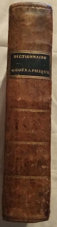
1810WOC-1373ou description des quatre parties du monde, par Vosgien. Nouvelle édition augmentée et entièrement refondue, renfermant les changements survenus par suite des différents traités, jusques et y compris celui de Vienne, du mois d'octobre 1809 par Giraud. Cet ouvrage est orné de six Cartes géographiques, et suivi de Tableau de réduction des francs en livres tournois, et des livres tournois en francs. Lyon, Chez Tournachon-Molin, Libraire, 1810. Fort in-8 (21x5x13cm) relié demi veau marron, dos orné de filets dorés, titre doré sur cuir noir, coins légèrement écornés, et manque dans le coin supérieur de 4 pages. 788pp. 80€
44 pages, colour street maps. eng
(Mini Map Series). eng
96 pages, maps, index. eng
VG folded map, no publication date. 10155. eng
136 pages, illustrated, includes articles on the Blue Nile, polar bears, early American humans, the Fiordland national park, Lake Wobegon (Garrison Keillor) and Shipton's Arch. eng
5th edition. Good paperback. Covers creased. 10602. eng
264 pages, colour maps, index. eng
VG folded map, no publication date.10093. eng
24 pages, street maps. eng
Undated, colour map. eng
Undated, map mounted on cloth, some fraying at edges. eng
Undated, paper map with some tape repairs. eng
In colour. eng
Colour map. eng
colour maps, index, inscription of a previous owner on the inside front cover. eng
1st edition. Very good condition folded picture map and guide. ISBN 0951886908 50969. eng
Undated, map mounted on cloth. eng
Undated, closed tears to map. eng
Undated, colour map. eng
4 volume set, over 80 pages, illustrated, includes articles on the Kobe Earthquake, coastal pollution, ozone depletion and Pakistan. eng
252 pages, maps, figures, appendix, index, name of a previous owner on the front endpaper. (The Human Geographies Secondary Series ; Book 1) eng