BAEDEKER, Karl [Cartography - Germany]Biblio.com
125 résultats
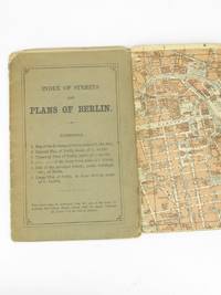
18935233Leipsic: Karl Baedeker 1893. Stiff Printed Wraps. Good. Wagner & Debes. 16mo. Pp. 11 street index 6 fold-out color maps. Saddle stapled green-gray printed wrap. Wrap fold split effaced pencil notes edges rubbed and soiled. Map corners creased. Pocket-size visitor's street guide in English with superb cartography by the firm of Eduard Wagner & Ernst Debes from the publisher's golden age under Fritz Baedeker. Preserved in a clear archival sleeve. Karl Baedeker unknown
1807Map960Paternoster Row London: Longman Hurst Rees & Orme 1807. 1st Edition 1st Printing. No Binding. Fine. Original early 19th century MAP of ALPINE COUNTRY from The North Sea to the border of AUSTRIA On MERCATORS PROJECTION BY AARON ARROWSMITH. A FINE AND DARK IMPRESSION. Original folding plate printed on heavy paper dated 1804. A scarce example and in fine un-coloured original condition. SOME FOXING. 41x27cms. Double-page folding map. <br/> <br/> Longman, Hurst, Rees & Orme unknown
1807Map959Paternoster Row London: Longman Hurst Rees & Orme 1807. 1st Edition 1st Printing. No Binding. Good. Original early 19th century MAP of ALPINE COUNTRY from The North Sea to the border of Switzerland On MERCATORS PROJECTION BY AARON ARROWSMITH. A FINE AND DARK IMPRESSION. Original folding plate printed on heavy paper dated 1804. A scarce example and in fine un-coloured original condition. SOME FOXING. 41x27cms. Double-page folding map. <br/> <br/> Longman, Hurst, Rees & Orme unknown
1848Map 474London: George Virtue 1848. No Binding. Vg. 10.75"x 8.25" Later hand-colour. Original steel engraving <br/> <br/> George Virtue unknown
1807Map951Paternoster Row London: Longman Hurst Rees & Orme 1807. 1st Edition 1st Printing. No Binding. Fine. Folio - over 12 - 15" tall. Original early 19th century uncoloured MAP OF THE SEVEN UNITED PROVINCES BY AARON ARROWSMITH. A DARK IMPRESSION. BUT DAMP EVIDENCE TO THE PAPER. Original folding plate covering SPAIN AND PORTUGAL printed on heavy paper dated 1807. A scarce example and in fine un-coloured original condition. An occasional light foxing mark. 41x27cms. Double-page folding map. engraved by COOPER.A LOVELY COPY. paper watermark dated 1808 <br/> <br/> Longman, Hurst, Rees & Orme unknown
1842Map 818Edinburgh: A&C Black 1842. No Binding. Fine/uncoloured. Beautiful steel engravings from Encyclopaedia Britanica Seventh edition dated 1842. Plates CCCXVIII and CCXIX 1-2 . Fine examples with no wear. Trifle foxing. 270x380mm. Engraved by Sidney Hall Bloomsbury. Published by A. & C. Black. <br/> <br/> A&C Black unknown
1842Map 816Edinburgh: A&C Black 1842. No Binding. Fine/uncoloured. Beautiful steel engravings from Encyclopaedia Britanica Seventh edition dated 1842. Plates CCCXVIII and CCLXIV-V .Fine examples with no wear. 270x380mm. Engraved by Sidney Hall Bloomsbury. Published by A. & C. Black. <br/> <br/> A&C Black unknown
1842Map 809Edinburgh: A&C Black 1842. No Binding. Fine/uncoloured. Beautiful steel engravings from Encyclopaedia Britanica Seventh edition dated 1842. Plates CCLXXVIII -1 and 2 .Fine example with no wear. 410x260mm. Engraved by Sidney Hall Bloomsbury. Published by A. & C. Black. <br/> <br/> A&C Black unknown
1842mAP 813Edinburgh: A&C Black 1842. No Binding. Fine/uncoloured. Beautiful steel engravings from Encyclopaedia Britanica Seventh edition dated 1842. Plates CCCXVIII and CCCXIX .Fine example with no wear. 270x380mm. Engraved by Sidney Hall Bloomsbury. Published by A. & C. Black. <br/> <br/> A&C Black unknown
1848Map 303London: George Virtue 1848. No Binding. Vg. 10.75"x 8.25" Later hand-colour. Original steel engraving <br/> <br/> George Virtue unknown
1869Map 725Ordnance Survey Office 1869. 1st Edition . Hardback. Vg. Folding map. Folding dissected map in 18 sections the rare first series edition laid on linen and cased in the original green cloth boards 6.75 x 4.5 inches with a hand-written paper label. Surveyed 1860-1871 and published in1869. Small grid of adjoining maps for the one inch and six inch series pasted to inside cover. 25x19 inches with hand-coloured roads. A nice copy a couple of small red ink marks otherwise clean with no wear or loss. There were 132 sheets for the complete Scottish ordnance maps and a second edition appeared in in 1898-1904 with coloured parishes. The one inch maps were based on larger scale surveys of 1843-1878 and published between 1856 and 1895. <br/> <br/> Ordnance Survey Office hardcover
1875Z032London: William Collins Sons and Company 1875. Second Edition . Hardback. Vg. small 8vo. BEING A CONCISE DESCRIPTIONS OF THE CHIEF PLACES OF INTEREST IN THE METROPOLIS ii 192 iipp. 58 illustrations by Sargent and Others and a Clue-Map by Bartholomew one section has a long closed tear with no loss. Advert end-papers. Orig. dec. brown cloth blocked in black and gilt. The British Library has an earlier edition of 1871. <br/> <br/> William Collins, Sons, and Company hardcover
1873GT173Exeter: H. Besley & Son 1873. 1st Edition . No Binding. Vg. Folding map. 54x41 cms.A single sheet folding bl/wh. map of Dartmoor laid on white linen backing within a small booklet. Pasted label 'DARTMOOR' Nd but National Lib. of Scotland states 1873. Scarce local map 2 only Copac with local names and details to the locations on the moor. <br/> <br/> H. Besley & Son unknown
1848Map 353London: George Virtue 1848. No Binding. Vg. 10.75"x 8.25" Later hand-colour. Original steel engraving <br/> <br/> George Virtue unknown
1848Map 824London: George Virtue 1848. re-issue . No Binding. Vg. 21 x 27 cms. Original un-coloured state with the later railway lines added since the first issue in 1832. Finely engraved views of Norfolk. A nice original dark impression steel engraving. <br/> <br/> George Virtue unknown
1848Map 825London: George Virtue 1848. re-issue . No Binding. Vg. 21 x 27 cms. Original un-coloured state with the later railway lines added since the first issue in 1832. Finely engraved views of Northamptonshire. A nice original dark impression steel engraving. <br/> <br/> George Virtue unknown
1848Map 399London: George Virtue 1848. No Binding. Vg. 10.75"x 8.25" Later hand-colour. Original steel engraving <br/> <br/> George Virtue unknown
1848Map 595London: George Virtue 1848. No Binding. Fine. 10.75"x 8.25" Later hand-colour. Original steel engraving <br/> <br/> George Virtue unknown
1848Map 821London: George Virtue 1848. re-issue . No Binding. Vg. W. Hughes. 27 x 21 cms. Original un-coloured state first issue in 1832. Finely engraved map of London spanning Harrow in the west to Barking in the east Wimbledon in the south to Finchley in the north. A nice original steel engraving with a dark impression. Some pencil lines on the reverse not affecting map <br/> <br/> George Virtue unknown
1843Map872London: Longman Hurst Row Orme & Co. 1843. 1st issue . Cloth. Vg. WALKERS COUNTY MAP SERIES. nd c1843. Folding map of KENTlaid on linen and dissected into 15 sections. Out-line hand-colour coloured woods and railway lines. Enclosed in a card case with a decorative paper label. Covers worn otherwise an attractive travellers map in a very clean condition. 34 x41 cms.13 x 16 inches <br/> <br/> Longman, Hurst, Row, Orme & Co. hardcover
1839W043Eton: E. Williams 1839. New and improved edition . Hardback. Fair. large 8vo. xviii 847 i adpp. Folding frontis. plate of the Solar system.; astronomical folding plate; folding plate of Athens. Lacks Rome and Syracuse plates. Title-page and frontis. loose and binding worn. READING/ REFERENCE COPY ONLY. <br/> <br/> E. Williams hardcover
1842Map 805Edinburgh: A&C Black 1842. No Binding. Fine/uncoloured. Folding plate of the two hemispheres. Beautiful steel engraving from Encyclopaedia Britanica Seventh edition dated 1842. Plate CCLXII. Fine example with no wear. Couple of small fox marks. Engraved by S. Hall Bury Str. Bloomsbury. Australia is named 'Australia and New Holland'. 400x280mm. <br/> <br/> A&C Black unknown
1890Map 728Scotland: Ordnance Survey Office 1890. 1st Edition . Hardback. Vg. Folding map. Folding map dissected in 18 sections the rare first series edition laid on linen and cased in the original green cloth boards 6.75 x 4.5 inches with a hand-written paper label. Surveyed 1859 -1863 and published in1890. Small grid of adjoining maps for the one inch and six inch series pasted to inside cover. 25x19 inches with hand-coloured roads. A nice copy with no wear or loss. There were 132 sheets for the complete Scottish ordnance maps and a second edition appeared in in 1898-1904 with coloured parishes. The one inch maps were based on larger scale surveys of 1843-1878 and published between 1856 and 1895. <br/> <br/> Ordnance Survey Office hardcover
1867Map 731Scotland: Ordnance Survey Office 1867. 1st Edition . Hardback. Vg. Folding map. Folding map dissected in 18 sections the rare first series edition laid on linen and cased in the original green cloth boards 6.75 x 4.5 inches with a hand-written paper label. Surveyed 1859-1864 and published in1867. Small grid of adjoining maps for the one inch and six inch series pasted to inside cover. 25x19 inches with hand-coloured roads. A nice copy with no wear or loss. There were 132 sheets for the complete Scottish ordnance maps and a second edition appeared in in 1898-1904 with coloured parishes. The one inch maps were based on larger scale surveys of 1843-1878 and published between 1856 and 1895. <br/> <br/> Ordnance Survey Office hardcover
1876Map 729Scotland: Ordnance Survey Office 1876. 1st Edition . Hardback. Vg. Folding map. Folding map dissected in 18 sections the rare first series edition laid on linen and cased in the original green cloth boards 6.75 x 4.5 inches with a hand-written paper label. Surveyed 1860-1871 and published in1876. Small grid of adjoining maps for the one inch and six inch series pasted to inside cover. 25x19 inches with hand-coloured roads. A nice copy with no wear or loss. There were 132 sheets for the complete Scottish ordnance maps and a second edition appeared in in 1898-1904 with coloured parishes. The one inch maps were based on larger scale surveys of 1843-1878 and published between 1856 and 1895. <br/> <br/> Ordnance Survey Office hardcover