148 résultats
183917778Boston & Paris: David H. Williams 1839. 10 maps some with several to the sheet; with handcolored maps including: Roman Empire; Italy; Greece; Asia Minor; The World exhibiting the Countries mentioned in the Old Testament; Journeyings of the Israelites from Egypt to Canaan; Judah and Israel with the Division of the Twelve Tribes; Palestine or the Holy Land; Ancient Jerusalem with its Environs; Map Illustrative of the Travels of St. Paul; approx. 9 1/2" x 11 1/2" size; yellow printed paper coverd paper stock binding; covers very worn chipped & stained; maps are on a softer paper; detached from the binding and occasionally foxed some edgewear; overall maps in good condition and an interesting early American Christian religion & education atlas. Improved Edition. Soft Cover. Good. David H. Williams Paperback books
189927283Ottawa: issued by authority of Hon. Clifford Sifton 1899. Only edition English issue there was also an issue in Swedish; folio pp. 10; includes 5 color maps partly double-p.; original printed wrappers; inside wrappers with information on the trade centers of Canada population and agricultural statistics; some spotting and staining of the wrappers but generally very good. <br/><br/> issued by authority of Hon. Clifford Sifton unknown books
1889262371889. WOLVERTON'S ATLAS OF MONMOUTH COUNTY. EATONTOWN MAP 1889. A 20-inch by 30-inch hand-colored map of Eatontown also showing Monmouth Park and Oceanport. Probably one of the best early maps of Eatontown ever made. $150.00. unknown books
1889262421889. WOLVERTON'S ATLAS OF MONMOUTH COUNTY. HOWELL TOWNSHIP 1889 MAP. A 20-inch by 30-inch hand-colored map of Howell Township showing West Farms Fairfield Farmingdale Jerseyville Turkey Blue Ball Greenville Runyons Bethel and Squankum. $150.00. unknown books
1889262381889. WOLVERTON'S ATLAS OF MONMOUTH COUNTY. MILLSTONE TOWNSHIP 1889 MAP. A 20-inch by 30-inch hand-colored map of Millstone Township also showing the Navesink section of Middletown Township. $150.00. unknown books
1945139955Beverly Hills CA: United Artists 1945. Vintage pressbook for the 1945 film. <br/><br/>Ernie Pyle Meredith is a journalist who enlists in the US Army during WWII. During his tour of duty in Africa and Italy he documents the effects of war on the human condition illuminating catastrophe the consequences of combat and new partnerships in times of crisis all from a first-person narrative. The real Pyle won a Pulitzer Prize in 1944 for his war correspondence. <br/><br/>Nominated for four Academy Awards. <br/><br/>14x 21 inches. 22 pages and a laid-in ad sheet saddle stapled in monochrome wrappers folded horizontally as issued. Very Good plus with spine rubbing a few spine chips and light foxing overall. United Artists unknown books
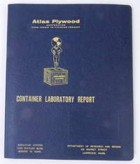
195627405Boston 16 Mass: Atlas Plywood Corporation 1956. Boards. Near Fine. 9 1/2 x 11 3/8 inches dimensions of tabbed loose leaf binder. Fourteen 8 x 10 inch approximate photographs plus "title page" photograph. Boards. A loose leaf binder with photographs depicting testing of crates and the attendant necessary equipment. Photos show a "large revolving drum" construction shop a compression machine what looks like a drop test chassis with crate affixed two photos of several men in a laboratory using a microscope and several other instruments a blueprint in progress two closeup images of instruments including a mullen tester a very large press used to compress pieces of plywood together testing in action and several other images. No doubt used as a sales tool demonstrating how thoroughly the company could build and test crates for reliable performance.<br/><br/>The tenth edition of Industrial Research Laboratories of the United States 1956 locates the Atlas Plywood Corporation's Department of Research and Design at 431 Market Street Lawrence Mass. the same address as on the card cover of this folder hence our approximate dating. Atlas Plywood Corporation unknown books
4042Crew of the Atlas 3 Space Shuttle. Large over-sized signed FDC from the day of the launch November 3 1994. Envelope measures 5x12" and is decorated with a brightly colored decal commemorating the launch. Signed by the entire crew "McMonagle" "Brown" "Ochoa" Tanner" "Parazynski" and "Clervoy." Very attractive. unknown books
1876010487London: George Philip & Son 1876. Hardcover. VG. 8vo publishers brown pebbled cloth gilt vignette and titles front gilt spine titles corners moderately worn binding firm all maps extant. Apparently unused internals near fine George Philip & Son hardcover books
195026144New York New York: Hagstrom Company 1950. 102 pages; illustrated with color maps and in black and white throughout. Also providing the Land Owners in Nassau County House numbers in Queens County Cemeteries street index and advertisements for Long Island businesses. Approx. 12 1/4" x 17" size sepia-tone paper illustrated covers & plastic spiral binding. Some edge tips wear and old staining to covers; first leaf detached and present; contents clean and in very good condition. With useful demographic property development history information for Long Island's Nassau & Queens counties. Second Edition. Spiral Bound. Very Good. Hagstrom Company paperback books
1983245329London 1983. Special Collector's edition for the Royal Geographical Society of the Times Atlas of the World. Illus. 226 pp. 1 vols. Folio. Bound in publisher's blue morocco with Seal of the Royal Geographic Society on front cover a.e.g. moire endpapers. Fine. Special Collector's edition for the Royal Geographical Society of the Times Atlas of the World. Illus. 226 pp. 1 vols. Folio. unknown books
1879781391879. Atlas volume. MAPS ACCOMPANYING PROCEEDINGS OF A BOARD OF OFFICERS APPOINTED TO EXAMINE INTO AND REPORT UPON THE CASE OF FITZ-JOHN PORTER. Washington: Government Printing Office 1879. Twenty-two folding maps and one folding letterpress description. Bound in contemporary three-quarter brown leather with marbled sides. Bookplate and ink stamp of William Crowninshield Endicott on front endpapers. The leather parts of the binding are very deteriorated and the top board is detached. One map no. 18 has a skillful paper repair at the inside margin. Another map no. 22 is just starting on a few folds. And a few maps have some occasional light foxing and splits along seams. Otherwise the plates are quite crisp and clean. Very good plates in an as-is binding. unknown books
195925043Moscow U.S.S.R.: MVD Ministry of Internal Affairs USSR 1959. viii 191 pages; useful index. Very well-printed lithographed color maps and charts. With geographic maps maps and charts of the solar system physical features climate world and country-by-country maps; more than half of the atlas concerns the then-U.S.S.R; text entirely in Cyrillic. Laid-in is an article from the NY Times Jan. 28 1973: 'Chinese Names for Towns in Siberia are Eliminated.' The volume approx. 10 3/4" x 15" size; bound in red cloth gilt cover and spine titles dulled; some edge tips wear and rubbing to the boards; contents clean maps' coloring bright and in very good condition. . First Edition. Hard Cover. Very Good. MVD (Ministry of Internal Affairs USSR) hardcover books
1972293032Calcutta: Ministry of Education & Youth Services Government of India 1972. Hard Cover. Very Good binding. This folio atlas is 22 x 16.5" and is comprised of 35 double page plates some of which are folded. Housed in a blue binder which has the beginnings of separation at the front joint but which is holding well. The boards are lightly soiled but the maps are fine with no ownership or other marks.~~The atlas covers inter alia rainfall soils land use crops groundwater river basins and irrigation. Very Good binding. Ministry of Education & Youth Services | Government of India unknown books
318424Edinburgh: W. & A.K. Johnston nd. 24th Edition 240000th. With a tipped in 1842 Map of South America as Frontispiece. Folio. Bound in three quarters modern half brown mottled calf. Fine. 24th Edition 240000th. With a tipped in 1842 Map of South America as Frontispiece. Folio. W. & A.K. Johnston unknown books
18826274Chicago and Toledo: H.H. Hardesty & Co 1882. Hard Cover. Small Folio. Illustrated containing large scale copper plate maps of each state and territory of the United States and the provinces of Canada together with a complete reference map of the world topographical and railroad map of the United States thirteen comprehensive maps of Bible geography covering all the countries of Bible history with classified pronunciative index of each map printed in colors from plates secured by letters patent producing the clearest typographical effect of any known engraved plates accompanied by a general survey of the world history of the United States-History of each state and territory of the United States outline map and history of Lawrence County Ohio. Containing a condensed history of the County; Biographical sketches; general statistics; miscellaneous matters etc. Frontispiece depicts Geysers in the Yellowstone Valley 60 of 61maps present lacking #44 &45 which is the United States the five folding maps are on stubs and printed on a much thinner paper with the map of New York laid in closed tear on map #164 small loss at lower edge of map #165. Re-backed and cornered in brown leather retaining original gilt stamped brown cloth endpapers renewed. A very good copy with excellent maps. <br/><br/> H.H. Hardesty & Co hardcover books
1910138694Berlin: Ferd. Dümmlers Verlagsbuchhandlung 1910. Octavo two volumes in one: pp. 1-6 1-241 242: blank; 1-2: title leaf for volume 2 243 244-475 476: blank rebound in three-quarter green pebbled leather and decorated boards all edges stained black marbled endpapers. First edition. Penon a utopian nation is created in a huge basin in the Atlantic Ocean. Its founder has discovered the original power neutral force which makes all things possible. Penon conquers the world and forms a world state. With limitless power over mind and matter the Penonites employ bioengineering to redesign the planet and its inhabitants the race problem is solved by making the Negro and Asiatic races white. An intellectual aristocracy administers the world state but the real power is in the hands of the mind and mood-reading Kialus division which knows everyone's thoughts desires inclinations and wishes. ". the ne plus ultra of technological utopias ." - Kretzmann 1936 p. 114. Kretzmann The Pre-War German Utopian Novel 1890-1914 pp. 114-18; p. 210. Negley Utopian Literature 50. Bloch 2002 262. Rebound without the publisher's advertisements pp. 477-82 spine faded to brown a very good copy. #138694 Ferd. Dümmlers Verlagsbuchhandlung unknown books
189459354Springfield: L. J. Richards 1894. First Edition. folio bound in contemporary cloth stained especially the rear board and endpaper spine repaired by back tape. Little water stain in the margins of the title page but the maps are nice and clean and bright. 34 colored double page maps in all. L. J. Richards unknown books
6302New York nd ca.1855: D. Appleton & Co. Hard Cover. Folio. 228 text pages 56pp index with sixty-one elegantly engraved and colored maps with comparative scales. Maps are from the London sheets published by H.G. Collins. Internally clean and bright; bound in original cloth covered boards spine is 3/4 brown calf renewed to style; red leather lettering piece on spine gilt; new endpapers. A very good copy maps are fine. <br/><br/> D. Appleton & Co hardcover books
17616573Eton: J. Pote 1761. Hardcover. Very Good. 4to 224 x 175mm. 2 64pp. 26 of index. 26 engraved folding maps. Later half calf over marbled boards; some light edgewear; old repair to one map on verso some pencil notations in margins of several maps; a very good copy. Armorial bookplate of Eton collector F. Manley Sims and with the stamp of his Eton Collection on title page. Pomponius Mela was among the earliest of Roman geographers. This present work written circa AD 43 was first published at Milan in 1471. The short work De situ orbis libri III. occupies less than one hundred pages of ordinary print. It is laconic in style and deficient in method but of pure Latinity and occasionally relieved by pleasing word-pictures. Excepting the geographical parts of Plinyís Historia naturalis where Mela is cited as an important authority the De situ orbis is the only formal treatise on the subject in Classical Latin. The general views of the De situ orbis mainly agree with those current among Greek writers from Eratosthenes to Strabo. <br/><br/> Eton: J. Pote hardcover books
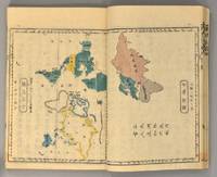
1837891931837. JAPANESE ATLAS Ichikawa Tôkei. KOKUGUN ZENZU 2 volumes. Nagoya Edo Ôsaka Kyôto. Eirakuya Tôshirô et al. Preface dated 1837. String-bound Japanese-style fukuro-toji printed paper title labels. Original yellow covers. Covers are a bit soiled with ownership labels. Internal occasional marginal worming. Printed in color woodblock throughout an interesting atlas of the traditional governing divisions of Edo-era Japan. unknown books
1871894281871. ATLAS Bridgeman E.C. translated by Mitsukuri Genpo 箕作阮甫. RENPO SHIRYAKU 連邦å²ç•¥ 2 vols. Tôkyô Zodiacal date of Meiji 4 1871. String-bound Japanese-style fukuro-toji. An interesting work by Bridgeman the Chinese missionary originally published in Chinese but here marked for reading as Japanese kanbun. Thus not a translation as we might understand the term but a long standing aid for literate Japanese to understand the original classical Chinese. With a number of bw and some color maps of the USA along with a text describing US history culture economics etc. A bit of cover soiling outside and the scattered signs of insect damage internally but overall a very good copy. Upon comparison to the original Japanese edition of 1861 there is not much to choose between them. unknown books
180828750Paris: P. Didot l'ainé 1808. Engraved frontispiece and 33 double-page hand-colored tables incorporating 21 smaller maps including a world map and a map of America. 1 vols. Folio. Contemporary quarter morocco and boards worn. Beautiful immaculate copy. Engraved frontispiece and 33 double-page hand-colored tables incorporating 21 smaller maps including a world map and a map of America. 1 vols. Folio. P. Didot l'ainé unknown books