(ATLAS)Biblio.com
156 résultats
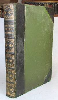
190752208London: The Amalgamated Press c. 1907. 4to. viii 32 284 pp. Contemporary possibly publisher's green half morocco over green cloth sides spine gilt top edge gilt. 3 colour plates of flags 210 map colour sheets mostly comprising double page maps but including single page maps and plans the 32 pages towards the rear also featuring numerous colour maps and diagrams. Covers worn but sound the front hinge weakened though it is still holding contents generally pretty good. London: [The Amalgamated Press] unknown
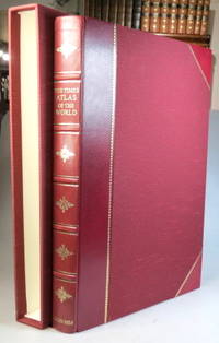
199937957London: Times Books; The Folio Society 1999. Limited edition no. 810 of 1000 copies folio 67 249 220 4 pp. 123 double page and one single page coloured map. Maroon half goatskin slipcase a couple of minor marks to the spine ends otherwise a lovely copy. (London: Times Books; The Folio Society unknown
193872459Chicago: Rand McNally & American Hotel Register Co. 1938. First edition of this merging of two American atlases. Folio 10 1/2 x 16 inches. The Rand McNally section is pp. 1-52 at the beginning and pp. 52-105 at the end. All maps printed in blue and red. The Leahy section starts in the middle and runs from p. 1 to p. 112 and with two more pages. These maps are entirely printed in black and much of the section is take up with listing for hotels in various states. Publisher's green cloth with gilt cover lettering Leahy's. The text block was originally stapled into the covers but has since come loose from the staples but the text block is entirely secure. A very good copy of an unusual publication.As both companies were headquartered in Chicago it is easy to imagine a friendly lunch at which this was discussed. Rand McNally & American Hotel Register Co. hardcover
1988199800Lond. John Bartholomew & Times Bks. 1988. Elephant folio. Or.bds. Dustjacket. xlvii123 colour plates 228pp. Index-gazatteer. Fine copy. A splendid reference atlas. Lond. John Bartholomew & Times Bks. unknown
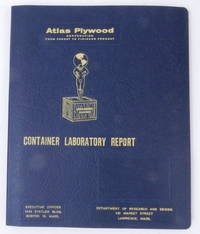
195627405Boston 16 Mass: Atlas Plywood Corporation 1956. Boards. Near Fine. 9 1/2 x 11 3/8 inches dimensions of tabbed loose leaf binder. Fourteen 8 x 10 inch approximate photographs plus "title page" photograph. Boards. A loose leaf binder with photographs depicting testing of crates and the attendant necessary equipment. Photos show a "large revolving drum" construction shop a compression machine what looks like a drop test chassis with crate affixed two photos of several men in a laboratory using a microscope and several other instruments a blueprint in progress two closeup images of instruments including a mullen tester a very large press used to compress pieces of plywood together testing in action and several other images. No doubt used as a sales tool demonstrating how thoroughly the company could build and test crates for reliable performance.<br /> <br /> The tenth edition of Industrial Research Laboratories of the United States 1956 locates the Atlas Plywood Corporation's Department of Research and Design at 431 Market Street Lawrence Mass. the same address as on the card cover of this folder hence our approximate dating. Atlas Plywood Corporation unknown
191656549Washington D.C. & Juneau A.T.: Superintendent of Documents U.S. Surveyor General’s Office 1916. Oblong Atlas Folio. 24 x 19 in. 14 colour maps 1 large folding 17.25 x 41.5 in. Printed softcovers stapled and paper reinforcement at gutter margin some minor toning & soiling to fore-edges edgewear to spine minor scuffing and a couple removed label ghosting still VG- bright copy. First edition of this remarkably scarce plat map atlas for the Matanuska coal fields and township sites surveyed by Walker & McDaniel during their surveys following those on the Kenai Peninsula. By 1912 with the act establishing Alaska as a U.S. Territory and in 1914 the authorization to construct an Alaska Railroad there became an increased need and demand for coal. The Matanuska mines located about 45 miles northeast of Anchorage first began production in 1916 and would stay in continuous production through both World War I and World War II and well into the 20th Century re-opening again in the 21st Century. Not only do these maps show available government lease sites for coal mines but also available Township sites for homesteaders as required by the original Homestead Acts of 1866 and the 1916 Act for Alaska requiring surveys and resurveys to accurately determine boundaries of unsold railroad lands and identify their boundaries. Worldcat locates 2 copies Anchorage Museum & Univ. of Calgary; See: Catalogue of the Public Documents of the Sixty-Fourth Congress Index Vol. 13 1922 p. 74; C. Albert White A History of the Rectangular Survey System 1983 p. 189. Superintendent of Documents, U.S. Surveyor General’s Office, paperback
194225894New York: Wilson Distilling Company Inc 1942. Fine. Unusual WWII era die cut atlas consisting of four circular panels printed on front and back with the 2 hemispheres of the globe in color on the front panels. These open to 2 panels of color illustrations featuring Wilson's Whiskey elegantly presented on a silver tray in front of a globe with the tag lines "No Better Whiskey in the World . Wilson That's All".<br /> <br /> The verso opens to 4 panels of printed text under the heading "Do You Know That" with interesting facts about nations around the world including this unusual information concerning Australia: "About one third of the adult population owns property and four fifths possess bank accounts."!<br /> <br /> Opens to 24 x 6 1/4"; folds to 6 x 6 1/4". Fine condition very bright and clean. Not found on Trove. OCLC: 1086382147 records only one copy at the Newberry Library. Wilson Distilling Company Inc unknown
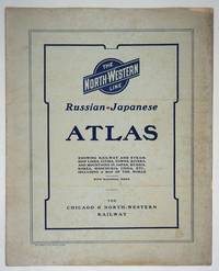
190427334Chicago: Rand McNally and Company; Chicago and North Western Railway Company 1904. First printing. Staplebound Wraps. Very good condition. Maps of the Russo-Japanese War five maps with a key printed in the margins comprised by the North-Western Line on inside front cover b&w World map; Asia; Eastern China; Japan and Korea all in color and 'the Only Double-Track Railway Between Chicago and the Missouri River and the Route of the Overland Limited' inside the back cover b&w. <br /> <br /> OCLC: 928938679 at Newberry Library Baskes Collection. Small folio printed paper wrappers grey covers with blue titles on front/back. Maps in color and b&w. Covers dusty slt. chip on foredge original folds. Rand McNally and Company; Chicago and North Western Railway Company unknown
1906867321906. ATLAS. ATLAS OF THE TOWNS OF REVERE AND WINTHROP SUFFOLK COUNTY MASS. Boston: Whitman & Howard 1906. Folio. 22". Double page maps measure 32" by 22". All plans are drawn to a scale of 150 feet to one inch except index map. Includes street index outline and index map and 25 double-page maps. Interiors are in good condition with some light staining throughout at head and spine pencil or ink annotations to title page and plates 3 4 5 8. Exteriors are fair with heavily worn half-leather with black cloth boards and gilt-stamped edges. A good copy. unknown
1922830191922. Ordnance Survey Southampton. 1922. Landscape 4to. Maroon cloth gilt to upper board. 24 linen-backed colour maps each measuring 75 x 35 cm. Extremities a llittle rubbed; a little mild soiling and some surface scratch marks to boards with discolouration to cloth at bottom edge of rear board; small white paint spots to spine. All maps clean and sound. hardcover
1980122499New York: Times Books 1980. Hardcover. fine. Comprehensive edition. xl227pp. Folio. Illustrated with coloured maps and photos. Original black cloth with gilt lettering on front cover and spine in dust jacket. Fine condition. 1980 Times Books hardcover
1970129115London: Thames and Hudson 1970. Hardcover. Fine. London Thames and Hudson 1970s facsimile edition/ 1645 and 1654. Folio xvi pages plus 115 double-page maps 5 in colour and 2 facsimile colour title pages all plates printed one side of each leaf only. Half morocco and cloth; tiny light mark to the leading edge; endpapers slightly discoloured by the leather turn-ins; essentially a fine copy with the lightly scuffed slipcase. Number 26 of only 500 copies; with an introduction by R.V. Tooley. Thames and Hudson hardcover
195910437Cleveland OH: Bloch and Compant 1959. First edition. Hard Cover. Very Good mild ex-library. Folio pp 10 per volume. Full set consists of Set 1: North America feat. maps produced in 1757; Set II: South America feat. maps produces 1753-57; Set III: Mexico Central America and the West Indies feat. maps produced 1754-58; Set IV: Africa feat. maps produced 1738-46; and Set V: Asia feat maps produced 1748-52. In very good condition only minor library markings. This series is a good set of old reference maps from around the world. Bloch and Compant hardcover
199414585Stockholm: SNA Publishing 1994. First edition. Blue Full Leather With Gilt Lettering. Very good condition but mild ex-library. Folio pp. 160. Indexed profusely illustrated in b/w and color. A very nice ex-library copy of this scarce volume of the National Atlas of Sweden. SNA Publishing hardcover
199414586Stockholm: SNA Publishing 1994. First edition. Blue Full Leather With Gilt Lettering. Very good condition but mild ex-library. Folio pp. 160. Indexed profusely illustrated in b/w and color. A very nice ex-library copy of this scarce volume of the National Atlas of Sweden. SNA Publishing hardcover
197058684Taipei Taiwan: Ch’eng Wen Publishing Co. P.O. box 22605 1970. Folio. 8.25 x 13.25 in. 112 pp. With 84 colour maps & diagrams many double-page. Blue linen gilt lettering on spine NF copy. First Taipei Ch’eng Wen reprint edition of this uncommon atlas first issued by Harvard University press in 1935. The colour maps trace China’s geography and political development from 1900 B.C. through 1930 with detailed maps charting the evolution of Asia and Asiatic empires. Of particular interest are the two final maps tracing the Chinese diaspora throughout the world and specifying population numbers of Chinese-Americans in the U.S. between the Wars. Ch’eng Wen Publishing Co., P.O. box 22605, unknown
190763122Chicago & New York: George F. Cram 55-61 Market Street 1907. Folio. 12.25 x 15 in. 160 pp. Illustrated title in blue. Over 100 photo illustrations maps colour maps many double-page with Cram’s Kansas 51.5 x 31.5 inch map in full colour laid-in minor soiling faint markings from glue offsetting where previously attached to rear pastedown. Dark forest-green coloured publisher’s cloth silver lettering & decoration embossed on front cover minor soiling minor wear to corners slight bumping head & foot of spine light restoration back cover still a VG- copy. First edition of this rare Cram’s reference atlas replete with colour World maps and maps of the individual states and many different local cities including Omaha Minneapolis St. Paul St. Louis Chicago and others. The section on Kansas includes two colour maps depicting manufacturing and mechanical industries by counties as well as statistical map showing live stock and dairy products. The photos depict the Kansas oil fields brick yards in Pittsburg KS; oil tank farms in Neodesha Strawboard Factory in Coffeyville streets in Atchison and other areas across the state. The atlas is also unusually complete with the very scarce giant oversize colour Kansas map typically missing from these Cram’s local history reference atlases. George F. Cram, 55-61 Market Street, hardcover
195059129Portland OR: Multnomah County Assessor’s Office ca. 1950. Oblong folio. 21 x 13.5 in. 1 1-71 74 leaves as issued. Including Multnomah County key map w/ 73 whiteprint diazo process maps all w/ borders key map w/ small closed tear at lower fore-edge w/ ghosting from old removed scotch tape now neatly repaired on verso. Original black cloth post-binder gilt lettering stamped on front cover 3 nickel-plates screwposts at gutter margin minor rubbing still VG copy. First edition thus of this exceedingly scarce plat map atlas for Multnomah County Oregon surveyed and issued after the famed May 30 1948 Memorial Day flood destroyed Vanport the Wartime Housing Authority of Portland project still existing following V-J Day 3 years earlier. The Vanport community housed the majority of African-American residents in Oregon who were prevented through racist real estate covenants and local ordinances from moving elsewhere prior to the flood and afterwards 1000’s were confined to the Albina area of North Portland. In addition the ongoing highway project for Highway 99 or the Pacific Highway is still demarcated without reference to I-5 which after the 1956 Highway Act would eventually serve to sever North Portland and eliminate entire neighborhoods when later completed. These maps offer an essential snapshot of development in Post-War Portland and guide to neighborhoods and land developments radically changed by expansion of the Portland Airport Interstate Construction and more. Worldcat locates 1 copy OR Hist. Soc. Lib. incorrect collation. Multnomah County Assessor’s Office, hardcover
192955692Portland OR & Tacoma WA: Metsker the Map Man 1929. Oblong atlas folio. 18 x 14.5 in. 45 leaves cyanotype blueprints. Including 44 detailed blueprint plat maps consistently dated 1929 1 large folding key map sized 24.5 x 14.25 in. Publisher’s flexible simulated calf post-binder gilt lettering title stamped on front cover burgundy-coloured silk more pastedowns neat typed label affixed to upper fore-edge of spine minor rubbing shelfwear NF copy. First edition thus of this exceedingly scarce Marion County Metsker plat map atlas providing invaluable historical and genealogical data for 1920s Salem Turner Silverton Stayton and as far north as the area around Aurora Oregon. The index provides specific names and locations for Donation Land Claims Fruit Farms and Tracts including logging and sawmill tracts as well as cities towns and suburban additions. Metsker 1881-1966 civil engineer and mapmaker began working as a teenager with his father in a Winlock WA sawmill by 1900 and later by 1910 ahd become a draftsman in an engineering office in Tacoma WA followed during the next 15 years by stints at engineering firms in Seattle Tacoma and Portland before striking out on his own as a mapmaker surveyor and mapmaker during the Roaring 20s. Metsker’s maps were sold by subscription and updated on an ongoing basis so the subscribers were supposed to throw out the earlier versions of the maps and replace them in the succeeding decades. They all received heavy use and the earliest versions created in the 1920s and 1930s are by far the scarcest of the atlases produced by the firm. Worldcat locates 3 copies of the 1929 Multnomah County Library OHS State Library of Oregon. Metsker the Map Man, unknown
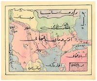
1910ABC_47241Ottoman Empire 1910. Gold-stamped cloth with the tughra of Mehmed V ruled 1908-18 on the front board when reading right to left and "Album" on the back board the front when reading left to right with an inscription below the tughra and the European numerals 16 and 2 flanking an ornament below the inscription the whole framed by 4 large floral cornerpieces. Oblong 4to 26.5 x 19.5 cm. 14 leaves with 10 pen-and-ink maps hand coloured with watercolours. Tissue guards. An album of hand-drawn maps forming an atlas of the western mostly European parts of the Ottoman Empire with legends in Ottoman Turkish written in the Arabic script. The overview map shows Albania Kosovo Macedonia and the Ottoman controlled northern parts of Greece coloured together with Thrace and the northwest parts of Anatolia shown treating them as a single unit while Serbia and Bulgaria like the small parts of territories outside Ottoman control are coloured separately. Most of the other maps give more detailed views of some of these regions including the Bosporus the Dardanelles Halkidiki Chalcidice Albania etc. but there is also a map of Crete not in the overview map.In fine condition. hardcover
190953081Seattle & Berkeley CA: Ellis A. Davis 1909. Folio. 190 pp. Illust. & decorated title 100s of photo illusts. over 100 colour maps many double page 1 very large folding colour map tipped-in on rear pastedown a couple minor closed tears at creases. Red cloth silver lettering & decoration embossed on front cover minor bumping to corners bumping & minor fraying head & foot of spine very faint tidemark to fore-edges still a VG- copy very clean and bright textblock. First edition of this well-illustrated commercial atlas intended to promote the Pacific Northwest during the Alaska-Yukon Exposition carefully listing most of the major and minor cities their counties industries local products and 100s of photos of buildings logging railroads shipping and more. The atlas includes detailed economic statistical maps of Oregon Washington and Idaho; street maps of Spokane WA Portland OR Seattle WA Boise ID and more. The large folding colour map at rear is of Oregon State -- these atlases were also issued with Idaho Washington and Oregon & Washington colour maps separately. Ellis A. Davis, hardcover
194764270Portland OR: Oregon Blue Print Co. 1947-1959. Oblong atlas folio. 21 x 17.5 in. 52 leaves not contiguously numbered. all dyazo-print whjteprint maps w/ first consisting of a large folding “Oswego Oregon Street Map†many leaves w/ creasing corners worn some with closed tears secured at gutter margin w/ 4 brass split-pins over thick brown paper stock still a VG- exemplar. First edition thus of this exceedingly rare realty atlas for Oswego Oregon chronicling its’ explosive growth following World War II prior to the consolidation with surrounding suburbs and renaming as the City of Lake Oswego in 1960. These real estate atlases were sold in installments to Lake Oswego & Portland area real estate agents land use boards and public institutions with installments appearing from 1947-1959 but the Oswego atlas sheets are far scarcer than even the very rare Portland issues. Oswego and surrounding suburbs such as Alto Park Acres Forest Hills Lake Grove Rainbow Terrace Uplands Crest and Woodmont were all developed initially by the Ladd Estate Company which first platted the area with Paul C. Murphy overseeing the design with the aid of of Frederick & John Olmsted to create a park like setting around the Lake. This atlas with key map opening details the evolution from 1947-1959 the street-by-street and plat-by-plat of the surrounding area providing essential information on the emergence of these suburbs from the original donation land claims as the city grew from about 1500 to over 10000 by 1959. The more than 100 new residential plats created from the original donation land claims throughout the Lake Oswego area including the plats on the south side of South Shore Drive which created the Palisades Neighborhood and just prior to the July 2 1959 annexation which brought all of Oswego Lake parts of Lake Grove Palisades and others in the Lake Grove Sanitary District all evolve through these maps. Researchers can trace the evolution of the Portland-Salem Expressway later called the Baldock Freeway and further developed into the I-5 corridor alongside Lake Oswego along with the rapid growth of the area. Original Donation Land Claims are clearly demarcated including those of Charles Brown Bryant Waters Carman Albert Durham and many others. Oregon Blue Print Co. was established on SE Hawthorne in Portland OR by the early 1940’s and were the printers for the Pittmon maps which were extensively used and continually updated in the Portland area. Under Walter & Min Underwood the company focused on blueprinting and engineering plans as well as land promotion brochures and street maps. Company still remains family owned. It appears that later versions of the Oswego Oregon Street Map were used as land promotion brochures and some early versions do survive in holdings of Lake Oswego City Government and 1 in OHS but no other examples are located in Worldcat. No similar versions of this atlas have survived in institutional holdings that this cataloguer could identify accurately. See: Mid-Century Lake Oswego: A Look at Lake Oswego’s Modern Developments 1935-1965 August 2010. Oregon Blue Print Co., hardcover
19762859.1973<p>1976 Institute of Mediaeval Music hardcover; no dust jacket; lightcover wear; pages clean/tight; good condition</p> Institute of Mediaeval Music hardcover
198340060Fulton County Historical and Genealogical Society. VG/NONE. 1983. Hardcover. Oversize hardcover facsimile copy of original 1895 publication. Covers very clean bright with minimal wear; hinges sound uncracked; pages tight clean. Title on cover differs from title page and reads thus: Standard Atlas of Fulton County Illinois 1895.; . Fulton County Historical and Genealogical Society, hardcover
1934FG 3180-6Paris France: Horizons De France 1934. IN FRENCH - CAN NOT SHIP OVERSEAS BECAUSE OF SIZE unless you want to pay the Shipping & Illustrated -- Email for Pictures. Hard Cover. Good/No Jacket. Elephant Folio - over 15" - 23" tall. Horizons De France Hardcover