132 résultats
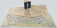
1880220946Japan. Circa 1880. Coloured bird's eye view map 38.3 x 52cm with original envelope somewhat worn folded colour map with neat washi repairs to the verso 39.2 x 127.7cm black and white diagram 28.2 x 52.8cm colour illustrated book 27.7 x 20cm 28 double-folded leaves four hole string binding title label on front cover with minor chips. Covers discoloured and worn but holding firmly internally bright and clean. This collection of three historical maps one diagram and an original envelope offers a detailed view of land use and planning in the Tsu’u region of Okayama Prefecture during the early Meiji period. The area had a long history of human habitation with fertile soil and abundant water sources. From the beginning of the Edo period in the 17th century land in the area was progressively reclaimed leading to an expansion of agricultural land. <br> <br>The collection comprises the following five items: <br>Detailed Map of Hayashima Shinden Village in Tsu’u County Bitchū 備中國都宇郡早嶋新田村明細地圖 <br>Land Division Map untitled in Japanese <br>Diagram of Natsukawa Village Primary School in Tsu’u County Okayama 備中國都宇郡撫川村小學校見取繪圖 <br>Pictorial Map of Additionally Registered Lands 地積追番雛形繪圖 <br>Original envelope with title <br> <br>Item 1 shows the divisions of rice-growing land in Hayashima Shinden Village with area measurements and registration numbers. Water channels are coloured in blue. <br>Item 2 is a large map showing land divisions in an adjacent area of Hayashima although it does not have a title. <br>Item 3 is a diagram of a primary school established in Natsukawa at the beginning of the Meiji period probably in the 1870s. An existing Buddhist temple and its compound were used for the school. The diagram identifies a fenced school yard pupils’ entrances to the classrooms at the rear and a flagpole standing beside the school gate. <br>Item 4 is a beautifully drawn bird’s-eye view map showing a settlement with a temple and shrine along a river surrounded by mountains forests and rice paddies. Item 5 is the original envelope titled Hayataka Village Map and most likely belongs with Item 4. . unknown
18872111902153000594Kawai Do 1887. Soft Cover. Fine. Number of pages: 26 pages including the cover Size: about 16 x about 11.5 cm wide Number of books: 1 Kawai Do paperback
18952082402113504749Not Available 1895. Soft Cover. Fine. Number of books: books Not Available paperback
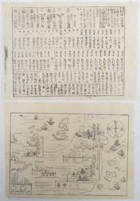
1865214219Japan. No date. Circa1865. Two small black and white woodblock kawaraban prints 22 x 29cm. Some worming but generally good. These two kawarabans showcase the Mōri family who held dominion over Chōshū in western Japan for more than 250 years. In the first kawaraban the main castle of Lord Mōri in Hagi along with smaller territories in Fuchu and Tokuyama are depicted featuring illustrations of their castles and residences. Sea surrounds their territories with their boats and other ships visible on the water. <br> <br>The second sheet provides a comprehensive list of the members of the Mōri family and their followers detailing their names and the levels of their earnings. Nearly one hundred names are listed providing insight into the structure and hierarchy within the Mōri family and its associated domains. These kawarabans offer valuable historical insights into the Mōri family's influence and organization during their reign over Chōshū. . unknown
18732111902156202536Not Available 1873. Soft Cover. Fine. Number of books: 3 Not Available paperback
18852111902160201161Kamiina Nagano Prefecture 1885. Soft Cover. Fine. Volume: 1 Kamiina, Nagano Prefecture paperback
18912111902160500796Not Available 1891. Soft Cover. Fine. Number of copies: Yamagata Prefecture Not Available paperback