[Maine]Biblio.com

244 résultats
192041272Washington D.C.: Published by the United States Coast and Geodetic Survey 1920. Large folding nautical chart printed on heavy paper stock. Uncolored. A rare original coastal survey of Maine from Little River to Petit Manan including Milbridge Addison Great Wass Island Preserve Jonesport Machias and an inset map of Moose-a-Bec Bar and Pig Island in top left corner.<br/> <br/> Established by President Thomas Jefferson in 1807 as the Survey of the Coast the U.S. Coast and Geodetic Survey was the United States' first civilian scientific agency. This agency has followed its mission to survey the U.S. coastline create nautical charts of the coast and help increase maritime safety since its founding and has often played fascinating roles in significant chapters of U.S. history. It served in all theaters of the Civil War in the service of the Union Army and Navy pioneered acoustic exploration in the wake of the sinking of the Titanic and during WWI it worked to detect enemy submarines. In addition this agency worked to survey and produce detailed maps and renderings of the U.S. coast. These nautical survey maps commonly referred to as "T-sheets" provide fascinating insights into the history of the United States coastline which has and will continue to shift. These maps are the most important data source for understanding the physical and ecological characteristics of the U.S. shoreline. The present map is a highly detailed and accurate sea chart of coastal Maine and an important historical view of the developing state. Published by the United States Coast and Geodetic Survey unknown
192041281Washington D.C.: Published by the United States Coast and Geodetic Survey 1920. Large folding nautical chart printed on heavy paper stock. Uncolored. A rare original coastal survey of Maine from Nash Island to Cross Island including Jonesport Jonesboro Great Wass Island Preserve and Bucks Harbor.<br/> <br/> Established by President Thomas Jefferson in 1807 as the Survey of the Coast the U.S. Coast and Geodetic Survey was the United States' first civilian scientific agency. This agency has followed its mission to survey the U.S. coastline create nautical charts of the coast and help increase maritime safety since its founding and has often played fascinating roles in significant chapters of U.S. history. It served in all theaters of the Civil War in the service of the Union Army and Navy pioneered acoustic exploration in the wake of the sinking of the Titanic and during WWI it worked to detect enemy submarines. In addition this agency worked to survey and produce detailed maps and renderings of the U.S. coast. These nautical survey maps commonly referred to as "T-sheets" provide fascinating insights into the history of the United States coastline which has and will continue to shift. These maps are the most important data source for understanding the physical and ecological characteristics of the U.S. shoreline. The present map is a highly detailed and accurate sea chart of coastal Maine from Cross Island to Nash Island and an important historical view of the developing state. Published by the United States Coast and Geodetic Survey unknown
192141280Washington D.C.: Published by the United States Coast and Geodetic Survey 1921. Large folding nautical chart printed on heavy paper stock. Colored. A rare original coastal survey of Maine from Petit Manan to Quoddy Roads including Harrington Addison Jonesport and Machias.<br/> <br/> Established by President Thomas Jefferson in 1807 as the Survey of the Coast the U.S. Coast and Geodetic Survey was the United States' first civilian scientific agency. This agency has followed its mission to survey the U.S. coastline create nautical charts of the coast and help increase maritime safety since its founding and has often played fascinating roles in significant chapters of U.S. history. It served in all theaters of the Civil War in the service of the Union Army and Navy pioneered acoustic exploration in the wake of the sinking of the Titanic and during WWI it worked to detect enemy submarines. In addition this agency worked to survey and produce detailed maps and renderings of the U.S. coast. These nautical survey maps commonly referred to as "T-sheets" provide fascinating insights into the history of the United States coastline which has and will continue to shift. These maps are the most important data source for understanding the physical and ecological characteristics of the U.S. shoreline. The present map is a highly detailed and accurate sea chart of coastal Maine from Quoddy Roads to Petit Manan and an important historical view of the developing state. Published by the United States Coast and Geodetic Survey unknown
192041288Washington D.C.: Published by the United States Coast and Geodetic Survey 1920. Large folding nautical chart printed on heavy paper stock. Colored. A rare original coastal survey of Portsmouth Harbor including Kittery Point New Castle Island and Portsmouth.<br/> <br/> Established by President Thomas Jefferson in 1807 as the Survey of the Coast the U.S. Coast and Geodetic Survey was the United States' first civilian scientific agency. This agency has followed its mission to survey the U.S. coastline create nautical charts of the coast and help increase maritime safety since its founding and has often played fascinating roles in significant chapters of U.S. history. It served in all theaters of the Civil War in the service of the Union Army and Navy pioneered acoustic exploration in the wake of the sinking of the Titanic and during WWI it worked to detect enemy submarines. In addition this agency worked to survey and produce detailed maps and renderings of the U.S. coast. These nautical survey maps commonly referred to as "T-sheets" provide fascinating insights into the history of the United States coastline which has and will continue to shift. These maps are the most important data source for understanding the physical and ecological characteristics of the U.S. shoreline. The present map is a highly detailed and accurate sea chart of Portsmouth Harbor and an important historical view of developing New Hampshire and Maine. Published by the United States Coast and Geodetic Survey unknown
192241276Washington D.C.: Published by the United States Coast and Geodetic Survey 1922. Large folding nautical chart printed on heavy paper stock. Colored. Bisected into two maps. A rare original coastal survey of Maine including Boothbay Harbor Bath and Georgetown.<br/> <br/> Established by President Thomas Jefferson in 1807 as the Survey of the Coast the U.S. Coast and Geodetic Survey was the United States' first civilian scientific agency. This agency has followed its mission to survey the U.S. coastline create nautical charts of the coast and help increase maritime safety since its founding and has often played fascinating roles in significant chapters of U.S. history. It served in all theaters of the Civil War in the service of the Union Army and Navy pioneered acoustic exploration in the wake of the sinking of the Titanic and during WWI it worked to detect enemy submarines. In addition this agency worked to survey and produce detailed maps and renderings of the U.S. coast. These nautical survey maps commonly referred to as "T-sheets" provide fascinating insights into the history of the United States coastline which has and will continue to shift. These maps are the most important data source for understanding the physical and ecological characteristics of the U.S. shoreline. The present map is a highly detailed and accurate sea chart of coastal Maine from Boothbay Harbor to Bath and an important historical view of the developing state. Published by the United States Coast and Geodetic Survey unknown
192041287Washington D.C.: Published by the United States Coast and Geodetic Survey 1920. Large folding nautical chart printed on heavy paper stock. Colored. A rare original coastal survey of Maine at East Penobscot Bay including the Fox Islands Deer Isle Stonington and Isle Au Hunt.<br/> <br/> Established by President Thomas Jefferson in 1807 as the Survey of the Coast the U.S. Coast and Geodetic Survey was the United States' first civilian scientific agency. This agency has followed its mission to survey the U.S. coastline create nautical charts of the coast and help increase maritime safety since its founding and has often played fascinating roles in significant chapters of U.S. history. It served in all theaters of the Civil War in the service of the Union Army and Navy pioneered acoustic exploration in the wake of the sinking of the Titanic and during WWI it worked to detect enemy submarines. In addition this agency worked to survey and produce detailed maps and renderings of the U.S. coast. These nautical survey maps commonly referred to as "T-sheets" provide fascinating insights into the history of the United States coastline which has and will continue to shift. These maps are the most important data source for understanding the physical and ecological characteristics of the U.S. shoreline. The present map is a highly detailed and accurate sea chart of East Penobscot Bay and an important historical view of developing Maine. Published by the United States Coast and Geodetic Survey unknown
192041284Washington D.C.: Published by the United States Coast and Geodetic Survey 1920. Large folding nautical chart printed on heavy paper stock. Colored. A rare original coastal survey of the Kennebec and Sheepscot Rivers including Bath Georgetown Boothbay and Wiscasset.<br/> <br/> Established by President Thomas Jefferson in 1807 as the Survey of the Coast the U.S. Coast and Geodetic Survey was the United States' first civilian scientific agency. This agency has followed its mission to survey the U.S. coastline create nautical charts of the coast and help increase maritime safety since its founding and has often played fascinating roles in significant chapters of U.S. history. It served in all theaters of the Civil War in the service of the Union Army and Navy pioneered acoustic exploration in the wake of the sinking of the Titanic and during WWI it worked to detect enemy submarines. In addition this agency worked to survey and produce detailed maps and renderings of the U.S. coast. These nautical survey maps commonly referred to as "T-sheets" provide fascinating insights into the history of the United States coastline which has and will continue to shift. These maps are the most important data source for understanding the physical and ecological characteristics of the U.S. shoreline. The present map is a highly detailed and accurate sea chart of the Kennebec and Sheepscot Rivers and an important historical view of developing Maine. Published by the United States Coast and Geodetic Survey unknown
192941282Washington D.C.: Published by the United States Coast and Geodetic Survey 1929. Large folding nautical chart printed on heavy paper stock. Colored. A rare original coastal survey of Maine from Monhegan Island to Cape Elizabeth including Bristol Damariscotta Wiscasset Boothbay Georgetown Harpswell Bath Brunswick Freeport Yarmouth and Portland.<br/> <br/> Established by President Thomas Jefferson in 1807 as the Survey of the Coast the U.S. Coast and Geodetic Survey was the United States' first civilian scientific agency. This agency has followed its mission to survey the U.S. coastline create nautical charts of the coast and help increase maritime safety since its founding and has often played fascinating roles in significant chapters of U.S. history. It served in all theaters of the Civil War in the service of the Union Army and Navy pioneered acoustic exploration in the wake of the sinking of the Titanic and during WWI it worked to detect enemy submarines. In addition this agency worked to survey and produce detailed maps and renderings of the U.S. coast. These nautical survey maps commonly referred to as "T-sheets" provide fascinating insights into the history of the United States coastline which has and will continue to shift. These maps are the most important data source for understanding the physical and ecological characteristics of the U.S. shoreline. The present map is a highly detailed and accurate sea chart of coastal Maine around Portland and an important historical view of the developing state. Published by the United States Coast and Geodetic Survey unknown
196126558London: Hodder and Stoughton. Near Fine in Near Fine dj. 1961. First Edition. Hardcover. price-clipped nice tight clean copy just the teensiest bumping to the lower front corner; the jacket is virtually flawless downgraded from Fine only because of the price-clipping and a touch of soiling to the rear panel. "John Soames is thirty years old and physiologically speaking alive. But by some trick of fate he has never become conscious. He is awoken and brought to full consciousness by a surgeon's knife a newborn baby with the body of a healthy young man." Basis for the 1970 British-American film of the same name starring Terence Stamp and Robert Vaughn; a critical and box-office disappointment on its original release the film has gained a bit of a retrospective cult reputation with one online critic calling it "a dark gem and a worthy pretender to the British horror hall of fame." Uncommon in the first edition all the more so in such outstanding condition. . Hodder and Stoughton hardcover
19389734London: John Murray 1938. Sara Delano Roosevelt's copy of her son's biography with her initials "SDR" in pencil to the front free end paper from the collection of Frederick Baldwin Adams a relative of FDR and his mother. Sara Delano Roosevelt clearly read the book with close interest as indicated by the marginal pencil lines scattered throughout the text. As these annotations are fairly extensive albeit heavily concentrated in the latter two-thirds of the book which concentrate on F.D.R.'s political career 1910s-1930s it is difficult to identify Sara's precise points of interest although there is the odd occurrence. For example on p.96 a less-encountered double-line is pencilled next to a sentence regarding F.D.R.'s embarkation on a new destroyer the Dyer during the First World War on which occasion "since he was sailing under secret orders neither his wife nor his mother could see him off" perhaps a difficult memory that stuck in Sara's mind. More broadly sections concerning family friends and commentary regarding F.D.R.'s political achievements appear to have elicited the most interest. A touching relic indicative of Sara's famous devotion and steadfast support for her son whom she lived to see elected three times as President of the United States. An account of the life and character of President Franklin Delano Roosevelt by family friend writer and music critic Basil Maine 1894-1972. The present copy comes from the Franklin Delano Roosevelt collection of Frederick Baldwin Adams Jr 1910-2001 the son of Ellen Walters Delano who was a first cousin to President Roosevelt. Adams became a passionate bibliophile who served as director of the Pierpont Morgan Library in New York City for two decades and compiled a significant personal collection relating to F.D.R. In 1969 he married his third wife who was a Swedish princess and with whom he shared the final years of his life in France. Adams' move to France explains the presence of his books in the United Kingdom. First edition. Publisher's original pink cloth with titles in gilt to the spine. Illustrated with nine black and white photographs. Panels of the original dustwrapper loosely laid in along with a newspaper obituary of Sir Sayaji Rao Indian ruler of Baroda who was a guest at the White House in 1934. A very good copy the binding square and firm with a little fading to the spine. The contents with toning to two text pages resulting from the insertion of the newspaper cutting are otherwise excellent throughout. Please contact Christian White Rare Books Ltd for more information or images of this item 1938 John Murray hardcover
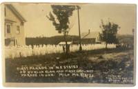
1923177341923. Clement Studio Ku Klux Klan march in Milo Maine 1923 documents the public visibility of the 1920s Klan revival in a rural Northeastern town. The image records the first daylight Ku Klux Klan parade and the first Klan parade in New England held during Milo's centennial celebration on September 3 1923. Its research value lies in its direct visual evidence of white supremacist performance anti-Catholic and anti-immigrant intimidation and the spread of Klan organizing beyond the South during the interwar period.<br /> <br /> Clement Studio. Ku Klux Klan march Milo Maine. Milo Maine: Clement Studio September 3 1923. Black-and-white silver gelatin real photo postcard. 5.25 x 3.5 inches. The photograph shows hooded Klansmen in white robes marching through Milo with several participants carrying American flags. The Metropolitan Museum of Art records a related Clement Studio image with the negative inscription: "First Parade in N.E. States of Ku Klux Klan. Milo. Maine Sept 3. 1923. Centennial Celebration."<br /> <br /> The photograph belongs to the period when the revived Klan used parades recruitment flags robes and public ceremony to normalize racial religious and nativist exclusion. In Maine Klan activity particularly targeted Catholic and immigrant communities including French Canadian and Irish populations while also drawing on national anti-Black anti-Jewish and anti-immigrant ideology. Minor small stain along upper margin not affecting image; very good. A stark local record of the Klan's Northeastern expansion and its use of daylight public spectacle as intimidation. unknown
192141274Washington D.C.: Published by the United States Coast and Geodetic Survey 1921. Large folding nautical chart printed on heavy paper stock. Colored. A rare original coastal survey of Maine around Casco Bay including Cape Elizabeth Portland Yarmouth Freeport and Harpswell.<br/> <br/> Established by President Thomas Jefferson in 1807 as the Survey of the Coast the U.S. Coast and Geodetic Survey was the United States' first civilian scientific agency. This agency has followed its mission to survey the U.S. coastline create nautical charts of the coast and help increase maritime safety since its founding and has often played fascinating roles in significant chapters of U.S. history. It served in all theaters of the Civil War in the service of the Union Army and Navy pioneered acoustic exploration in the wake of the sinking of the Titanic and during WWI it worked to detect enemy submarines. In addition this agency worked to survey and produce detailed maps and renderings of the U.S. coast. These nautical survey maps commonly referred to as "T-sheets" provide fascinating insights into the history of the United States coastline which has and will continue to shift. These maps are the most important data source for understanding the physical and ecological characteristics of the U.S. shoreline. The present map is a highly detailed and accurate sea chart of Casco Bay and an important historical view of developing Maine. Published by the United States Coast and Geodetic Survey unknown
192041271Washington D.C.: Published by the United States Coast and Geodetic Survey 1920. Large folding nautical chart printed on heavy paper stock. Colored. A rare original coastal survey of Penobscot Bay including Belfast Isleboro Deer Isle Stonington North Haven Vinalhaven Rockland Camden and Rockport.<br/> <br/> Established by President Thomas Jefferson in 1807 as the Survey of the Coast the U.S. Coast and Geodetic Survey was the United States' first civilian scientific agency. This agency has followed its mission to survey the U.S. coastline create nautical charts of the coast and help increase maritime safety since its founding and has often played fascinating roles in significant chapters of U.S. history. It served in all theaters of the Civil War in the service of the Union Army and Navy pioneered acoustic exploration in the wake of the sinking of the Titanic and during WWI it worked to detect enemy submarines. In addition this agency worked to survey and produce detailed maps and renderings of the U.S. coast. These nautical survey maps commonly referred to as "T-sheets" provide fascinating insights into the history of the United States coastline which has and will continue to shift. These maps are the most important data source for understanding the physical and ecological characteristics of the U.S. shoreline. The present map is a highly detailed and accurate sea chart of Penobscot Bay and an important historical view of developing Maine. Published by the United States Coast and Geodetic Survey unknown
192041279Washington D.C.: Published by the United States Coast and Geodetic Survey 1920. Large folding nautical chart printed on heavy paper stock. Colored. A rare original coastal survey of St. George River and the Muscle Ridge Channel including Thomaston Cushing and St. George.<br/> <br/> Established by President Thomas Jefferson in 1807 as the Survey of the Coast the U.S. Coast and Geodetic Survey was the United States' first civilian scientific agency. This agency has followed its mission to survey the U.S. coastline create nautical charts of the coast and help increase maritime safety since its founding and has often played fascinating roles in significant chapters of U.S. history. It served in all theaters of the Civil War in the service of the Union Army and Navy pioneered acoustic exploration in the wake of the sinking of the Titanic and during WWI it worked to detect enemy submarines. In addition this agency worked to survey and produce detailed maps and renderings of the U.S. coast. These nautical survey maps commonly referred to as "T-sheets" provide fascinating insights into the history of the United States coastline which has and will continue to shift. These maps are the most important data source for understanding the physical and ecological characteristics of the U.S. shoreline. The present map is a highly detailed and accurate sea chart of Maine and an important historical view of the developing state. Published by the United States Coast and Geodetic Survey unknown
192041277Washington D.C.: Published by the United States Coast and Geodetic Survey 1920. Large folding nautical chart printed on heavy paper stock. Colored. A rare original coastal survey of West Penobscot Bay including Camden Rockport Rockland the Fox Islands and Islesboro.<br/> <br/> Established by President Thomas Jefferson in 1807 as the Survey of the Coast the U.S. Coast and Geodetic Survey was the United States' first civilian scientific agency. This agency has followed its mission to survey the U.S. coastline create nautical charts of the coast and help increase maritime safety since its founding and has often played fascinating roles in significant chapters of U.S. history. It served in all theaters of the Civil War in the service of the Union Army and Navy pioneered acoustic exploration in the wake of the sinking of the Titanic and during WWI it worked to detect enemy submarines. In addition this agency worked to survey and produce detailed maps and renderings of the U.S. coast. These nautical survey maps commonly referred to as "T-sheets" provide fascinating insights into the history of the United States coastline which has and will continue to shift. These maps are the most important data source for understanding the physical and ecological characteristics of the U.S. shoreline. The present map is a highly detailed and accurate sea chart of Penobscot Bay and an important historical view of developing Maine. Published by the United States Coast and Geodetic Survey unknown
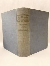
191151933Atlanta Ga: Self Published 1911. First Edition. Hardcover. Very good. 680p quarto illustrated. "It was her husband's request that she should collect qnd publish the story of his Congressional and Legislative life as connected with Georgia politics from 1874 during more than 20 years of public service in State and National Legislature" Salley Eugenia Brown's copy with her ownership signature on the front fly leaf. Brown 1862-1942 Miss Brown the daughter of Joseph E Brown Civil War Governor of Georgia. Martha "Pat" Simmons Garroway of Sargentville Maine related the story of Sally as a little girl watching General Sherman's troops march through Atlanta. Later she summered in Sargentville Mine and had a house at the end of Caterpillar Hill Road where it intersects with Reach Road. Inner hinges cracked but a surprisingly very good copy. <br/><br/> Self Published hardcover
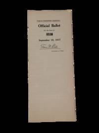
1917199681917. Putting forth a vote on the ballot to the citizens of Hiram Maine US concerning women's suffrage. Unfolded sheet is 25" x 9". September 10 1917. There are five amendments in total on the ballot with Proposed Amendment No.1 reading: "The right to vote or to hold office shall not be denied or abridged on account of sex." In 1917 the Maine Suffrage Amendment was defeated by a vote of 40000 to 20000 but by 1919 Maine became the third New England state to ratify the federal amendment and when a referendum vote was held Maine women won the right to vote in presidential elections. Also includes Proposed Amendment No.4 which proposed amendments to Article 7 of the Constitution regarding the rollout of American troops in WWI. A quarter-folded sheet with very minor age-toning to extremities and creases. Has facsimile signature of Maine Secretary of State Frank W. Ball on recto. In very good condition overall. unknown
196110537GOLDMANN WILHELM 1961. 1. hardcover. GOLDMANN, WILHELM hardcover
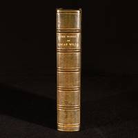
1949977Q25London and Glasgow : Collins 1949 . Leather. Near Fine. 8.5" by 5.5". None. A sumptuous Sangorski & Sutcliffe bound copy of the collected works of Oscar Wilde comprising his much celebrated novels plays poetry and other writings. Bound by Sangorski & Sutcliffe in half crushed morocco with cloth boards. The second impression of this "New Collected Edition" published by Collins. An anthology of the collected works of Oscar Wilde including his poetry plays essays and stories. Notable mentions include 'The Picture of Dorian Gray' 'The Importance of Being Earnest' 'The Sphinx' The Ballad of Reading Gaol' and more. Edited and with an introduction by G. F. Maine. Illustrated with a frontispiece of the author from a painting by Toulouse-Lautrec. Bound by Sangorski & Sutcliffe in half crushed morocco with cloth boards. Externally excellent with a few light marks to boards and spine. Slight fading to spine as is common with calf of this colour. Internally firmly bound. Pages are bright and clean with just one or two spots to the fore edge. Near Fine Collins hardcover
192041290Washington D.C.: Published by the United States Coast and Geodetic Survey 1920. Large folding nautical chart printed on heavy paper stock. Colored. A rare original coastal survey of Portland Harbor including Cape Elizabeth Westbrook and Portland.<br/> <br/> Established by President Thomas Jefferson in 1807 as the Survey of the Coast the U.S. Coast and Geodetic Survey was the United States' first civilian scientific agency. This agency has followed its mission to survey the U.S. coastline create nautical charts of the coast and help increase maritime safety since its founding and has often played fascinating roles in significant chapters of U.S. history. It served in all theaters of the Civil War in the service of the Union Army and Navy pioneered acoustic exploration in the wake of the sinking of the Titanic and during WWI it worked to detect enemy submarines. In addition this agency worked to survey and produce detailed maps and renderings of the U.S. coast. These nautical survey maps commonly referred to as "T-sheets" provide fascinating insights into the history of the United States coastline which has and will continue to shift. These maps are the most important data source for understanding the physical and ecological characteristics of the U.S. shoreline. The present map is a highly detailed and accurate sea chart of Portland Harbor and an important historical view of developing Maine. Published by the United States Coast and Geodetic Survey unknown
19155545Portland ME: Lefavor-Tower Co 1915. First Editions. Hardcover. Near Fine to Very Good Textblocks Fine. No DJ. First Editions. Hardcover. Arguably the more important collection of Maine related Civil War papers. Includes several essays from Joshua Chamberlain the capture of Mobile AL and Richmond VA an essay on "Colored Troops" the "Attitude of Women" about the war etc. Uncommon to find as a complete set and this one was clearly "built". Volume Four bears a presentation inscription to the Paris Hill Library N.B. there are no library markings from Henry W. Lyon "The first paper Hamlin Centennial Celabration will interest all citizens of Paris Hill." Overall a handsome set. Light shelf/edge wear tips of Vol. 3 gently bumped spine of Vol. 3 shows light toning Vol. 3 shows lightening at front lower corner Vol. 4 shows lightening spot near tail presentation inscription at fep of Vol. 4 bookplate lifted from Vol. 4 else tight bright and unmarred. Navy boards gilt lettering and decorative elements teg. 352pp plus errata; 349pp; 357pp; and 344pp. Illus. b/w plates. Index. Lefavor-Tower Co hardcover
1912167751912. Unidentified compiler. Photograph album of women's education and collegiate life 1912-1920 documents student experience leisure activities and social networks across Maine including institutions such as Colby College and the University of Maine. The album captures young women's participation in academic environments alongside outdoor recreation travel and community life situating female education within broader patterns of early twentieth-century mobility and social interaction. The material provides visual evidence of women's presence in expanding educational institutions and their integration into both structured and informal aspects of student life.<br /> <br /> Photograph album. Maine and various U.S. locations 1912-1920. Quarto format album with 187 silver gelatin photographs mounted across 42 pages with image sizes ranging from approximately 1.5 x 3.5 inches to 3.5 x 5.5 inches. The photographs depict locations throughout southern Maine including Portland Waterville Lamoine Boothbay North Pond and Ogunquit along with additional images from Texas Florida and New Hampshire. Academic settings are represented through images identified as Colby College including a figure labeled "Prof. Johnson Colby '18" and references to the Alpha Tau Omega fraternity "Hurrah for A.T.O.". Additional institutional references include "Nasson Institute 1912" a women's school in Springvale and the Phi Eta Kappa fraternity house at the University of Maine. Human subjects include students and faculty such as "Dean Hunt" as well as classmates in graduation attire. Recreational and social scenes include young women snowshoeing playing tennis and participating in outings labeled "Picnic to the quarry" "Clam Bake" and "Hot Dog Roast." Automotive travel appears in images of early motorcars while other photographs depict children in Sunday school groups bicycle riding and staged performances of "Pied Piper" and "Red Riding Hood." Additional images include a man in World War I-era military uniform "Adrian Old Top" and an individual identified as "Texas Bill" posing with a biplane. Informal scenes include three girls reading on a rooftop space labeled "The Sun Porch" with a related image documenting their ascent assisted by a male companion.<br /> <br /> The album spans a period of expanding access to higher education for women in the United States particularly in regional institutions across New England. The inclusion of both coeducational and women-focused institutions reflects the varied educational pathways available during this period. Recreational imagery including athletics and social outings demonstrates the integration of leisure into student identity while references to World War I-era figures situate the album within a broader national context. Original cloth boards with minor wear and three small holes to lower right quadrant of front cover; photographs well-preserved with strong clarity; overall very good condition. A substantial visual record of women's collegiate and social life in early twentieth-century Maine. unknown
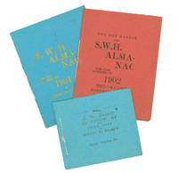
190263105Byerly Printing Co 1902. First and only edition. Illustrated by F. P. Byerly. 3 vols. 32mo. Blue red and green printed sewn wrappers. Fine. First and only edition. Illustrated by F. P. Byerly. 3 vols. 32mo. Amateur printing. Byerly Printing Co unknown