Antiquariat.de

4 438 résultats
1888K-113Wien, Milit?rgeographisches Institut, 1888. Formatangabe ca 50 x 37 cm, gefaltet zu 8 Segmenten, Ausgabe: einf?rbig; Zustand: gut
1914K-377Wien, Milit?rgeographisches Institut, um 1914. folgt der Ausgabe 1894, Formatangabe ca 50 x 37 cm, gefaltet zu 8 Segmenten ; Zustand: gut , teils mit Randnot. Am Kartenrand Bleistift
19412410150322xbvkTokyo, Tetsujiro Tanaka, Showa, 16 (1941). Titlepage in Japanese and English, halftransparent sheet with printed translation of the calligraphy on the following-, calligraphy-sheet, 2 sheets of Japanese text, large-foldout 'Map of showing the Distribution of National Parks'(Jap./Engl. Headline), 3 p. content in Japanese, 3 p. content in English, 4 p. Introdution in Japanese, 2 p. 'A short historical Outline of the National Parks in Japan.' and 'A few Characteristics of Japan and its National Parks.' by S. G. Strong, 11/9 p. with detailed lists of 'The Mountains in the National Parks of Japan.', 'The Waterfalls . . .', 'The Lakes and Marshes . . .', 'The Hot Springs', 'The historic Place[s,] The Sights and The natural Souvenir[s] . . .', 17 pages of Japanese Text; followed by descriptions of each National Park with seperate titlesheet, 4 pages of text including a map (and 8-20 singleside printed photographic plates): AKAN (8), DAISETSUZAN (10), TOWADA (11), NIKKO (13), FUJI - HAKONE (16), JAPANESE ALPS (20), YOSHINO & KUMANO (11), DAISEN (8), SETO INLAND SEA (10), ASO (9), UNZEN (9), KIRISHIMA (10); OVERALL 135 PLATES with 9 fold-out panoramas, 57 wholepage photographic plates, 39 pl. with 2 photos each, 10 pl. w. 3 photos, 19 pl. w. 4 photos, 1 pl. w: 5 photos; 255 PHOTOGRAPHIC VIEWS IN TOTAL. - Publisher's gilt titled (English and Japanese) flower-patterned bronze-colour silken blockbook-binding in the original clothfolder* with bone-clasps; oblong-folio (ca. 26 x 38 x 5 cm; ca. 3,1 kg.).
Very Good German Original color map on cloth. Oblong atlas folio. (48 x 63 cm). In Latin, Greek and German. Toponyms are Turkish in Latin transcription script as well as their ancient names in Roman and Greek. Including Afiun Karahisar [Afyonkarahisar] and its south and southwest area. Ascanius Lavus, Djemal Bey Tschiftligi, Macropedium, Asi Karaaghatsch, Denizli, Cretopolis, Sozopolis, Isparta, Tabenerum Campus, Hynera (Cydrara), Anaua Lacus (Adji Tuz Gölü), Ishikli Eumenia, Panasium (Banas Ovasi i.e. Plain), etc. It's one of the 24 sheets of 'Karte von Kleinasien'. Rihard Kiepert was a German cartographer born in Weimar. He was the son of famed geographer Heinrich Kiepert. Richard Kiepert studied geography and history in Berlin and Heidelberg. In 1870, he traveled in Palestine and Asia Minor, returning to take part in the Franco-Prussian War. In 1874, he received his doctorate of philosophy at the University of Jena. From 1874 until 1878 he worked on the compilation of Ferdinand von Richthofen's atlas of China, and from 1875 to 1887, he was editor of the geographical periodical Globus. From 1902 until 1908 he worked on the Spezialkarte von Kleinasien, a map of Asia Minor that was created on a 1:400,000 scale. After his father's death in 1899, he continued the work on the elder Kiepert's classic Formae Orbis Antiqui.
Very Good Turkish, Ottoman (1500-1928) Original color map on cloth. Folded. Wrinkled on paper. Stains on cloth. 12 sheets on paper. Oblong atlas folio. (50 x 60 cm). In Ottoman script.[MAP of ALEXANDRETTA] Iskenderun - Tayakadin. It shows villages and settlements in Tayakadin of Iskenderiye. Scale: 1/25.000. Hegira: 1329 = Gregorian: 1913. This is one the serie of the Bonn projection maps which are the first map series in modern techniques in Turkey and the Ottoman Empire. In order to produce these maps covering Turkish territory, Reconnaissance Branch was incorporated into The Mapping Commission. The maps were produced in the datum based on the latitude and longitude of Ayasofya Mosque in equal area Bonn Projection. The field works for the 123 sheets covering the country were conducted by 76 staff. The production was completed in 18 years starting from east west. Field works continued without stopping except in years 1914 and 1920. This map series called also reconnaissance maps contributed a lot to producing 1:25.000 scale maps. Not description on map-maker. A very detailed map. Extremely rare.
Very Good Turkish, Ottoman (1500-1928) Original color map. Folded. Oblong atlas folio. (50 x 60 cm). In Ottoman script. [MAP of EAST ANATOLIA and ARTVIN] Oltu, Artvin, Ispir, Hasankale. Shows Artvin, Ispir, Hasankale and Kars city. Scale: 1/200.000. This is one the serie of the Bonn projection maps which are the first map series in modern techniques in Turkey and the Ottoman Empire. In order to produce these maps covering Turkish territory, Reconnaissance Branch was incorporated into The Mapping Commission. The maps were produced in the datum based on the latitude and longitude of Ayasofya Mosque in equal area Bonn Projection. The field works for the 123 sheets covering the country were conducted by 76 staff. The production was completed in 18 years starting from east west. Field works continued without stopping except in years 1914 and 1920. This map series called also reconnaissance maps contributed a lot to producing 1:25.000 scale maps. Hegira: 1332 = Gregorian: 1916. Not description on map-maker.
Very Good Turkish, Ottoman (1500-1928) Original color map. Folded. Oblong atlas folio. (50 x 60 cm). In Ottoman script. [MAP of EAST ANATOLIA] Malatya - Divrigi, Mancinik, Adiyaman, Harput. Shows Malatya, Adiyaman and Kharpout region; Firat River (Euphrates), Yazi Düzü, Erguvan etc. Scale: 1/200.000. This is one the serie of the Bonn projection maps which are the first map series in modern techniques in Turkey and the Ottoman Empire. In order to produce these maps covering Turkish territory, Reconnaissance Branch was incorporated into The Mapping Commission. The maps were produced in the datum based on the latitude and longitude of Ayasofya Mosque in equal area Bonn Projection. The field works for the 123 sheets covering the country were conducted by 76 staff. The production was completed in 18 years starting from east west. Field works continued without stopping except in years 1914 and 1920. This map series called also reconnaissance maps contributed a lot to producing 1:25.000 scale maps. Hegira: 1332 = Gregorian: 1916. Not description on map-maker. According to Türkezer & Çobanoglu: History of Mapping in Turkey-1:200.000 Scale Maps, cartographer of this map is Kambay, Cemal.
Good Turkish, Ottoman (1500-1928) Original color map. Folded. Tears in margins. Slightly stained. Otherwise a good copy. Oblong atlas folio. (50 x 60 cm). In Ottoman script. [MAP of EAST BLACK SEA] Artvin, Rize, Oltu. Shows Artvin and Georgian borders, Rize (Rizeon - Rizunda - Rizini) and Oltu cities and regions. Scale: 1/200.000. Hegira: 1330 = Gregorian: 1914. This is one the serie of the Bonn projection maps which are the first map series in modern techniques in Turkey and the Ottoman Empire. In order to produce these maps covering Turkish territory, Reconnaissance Branch was incorporated into The Mapping Commission. The maps were produced in the datum based on the latitude and longitude of Ayasofya Mosque in equal area Bonn Projection. The field works for the 123 sheets covering the country were conducted by 76 staff. The production was completed in 18 years starting from east west. Field works continued without stopping except in years 1914 and 1920. This map series called also reconnaissance maps contributed a lot to producing 1:25.000 scale maps. Not description on map-maker. Extremely rare.
Very Good Turkish, Ottoman (1500-1928) Original color map. Folded. Oblong atlas folio. (50 x 60 cm). In Ottoman script. [MAP of EAST BLACK SEA] Trabzon, Giresun, Erzincan, Ispir. Shows Trebizond, Cerasonte, Erzingan (Eriza), Suspiritis (Sper) of Erzurum (Erzeron city); mostly Black Sea shores of Trabzon and Giresun. . Scale: 1/200.000. This is one the serie of the Bonn projection maps which are the first map series in modern techniques in Turkey and the Ottoman Empire. In order to produce these maps covering Turkish territory, Reconnaissance Branch was incorporated into The Mapping Commission. The maps were produced in the datum based on the latitude and longitude of Ayasofya Mosque in equal area Bonn Projection. The field works for the 123 sheets covering the country were conducted by 76 staff. The production was completed in 18 years starting from east west. Field works continued without stopping except in years 1914 and 1920. This map series called also reconnaissance maps contributed a lot to producing 1:25.000 scale maps. Hegira: 1336 = Gregorian: 1920. Not description on map-maker. Extremely rare.
Very Good Turkish, Ottoman (1500-1928) Original color map on cloth. Folded. Oblong atlas folio. (50 x 60 cm). In Ottoman script. [MAP of MAGNESIA - AEGEAN REGION] Manisa - Soma, Izmir, Aydin cities (Magnesia, Smyrna and Tralleis) in Aegean region. It shows villages and settlements in Tayakadin of Iskenderiye. Scale: 1/25.000. Hegira: 1328 = Gregorian: 1912. This is one the serie of the Bonn projection maps which are the first map series in modern techniques in Turkey and the Ottoman Empire. In order to produce these maps covering Turkish territory, Reconnaissance Branch was incorporated into The Mapping Commission. The maps were produced in the datum based on the latitude and longitude of Ayasofya Mosque in equal area Bonn Projection. The field works for the 123 sheets covering the country were conducted by 76 staff. The production was completed in 18 years starting from east west. Field works continued without stopping except in years 1914 and 1920. This map series called also reconnaissance maps contributed a lot to producing 1:25.000 scale maps. Not description on map-maker. A very detailed map showing lakes, rivers and mountains. Extremely rare.
Very Good English Paperback. Map in original wrappers. Roy. 8vo. (24 17 cm). Folded huge color map. (Size: 70x75 cm). In English and Turkish. [MAP] Geographical distribution of vegetation in Trakya (Thrace).= [Trakya bitki örtüsü haritasi]. Shows the forestries of Quercus, Fagus, Carpinus, Pinus, Castanea, Fraxinus, Longos; Salix Alba and Populus Alba along the Meriç Valley.; Maquis.; Rush and swamp.; Littoral plants.; The boundary of Maquis.; Agricultural areas. OCLC 976817060.
Very Good Turkish, Ottoman (1500-1928) Original color map of Erzurum city center and it environment. Folded. 69x42,5 cm. In Ottoman script. One sheet. Shows center of Erzurum city and topography environment. No scale info. Hegira: 1336 = Gregorian: 1920. Not description on map-maker. This is one the serie of the Bonn projection maps which are the first map series in modern techniques in Turkey and the Ottoman Empire. In order to produce these maps covering Turkish territory, Reconnaissance Branch was incorporated into The Mapping Commission. The maps were produced in the datum based on the latitude and longitude of Ayasofya Mosque in equal area Bonn Projection. The field works for the 123 sheets covering the country were conducted by 76 staff. The production was completed in 18 years starting from east west. Field works continued without stopping except in years 1914 and 1920. This map series called also reconnaissance maps contributed a lot to producing 1:25.000 scale maps. Extremely rare.
191667110[Berlin] : [Kgl. Preuss. Landesaufnahme] 1916. Aufnahme 1897, hrsg. 1899, b[er. 19]13, Aufl.dr. 1916 1 Kt. : Flachdruck, farbig (schwarz/blau); 50,5x48cm auf Leinen aufgezogen [2 Warenabbildungen] 0
Very Good Turkish, Ottoman (1500-1928) Original color map. Oblong atlas folio. (51 x 61 cm). In Ottoman script. Folded. Topography and toponyms of East Anatolia: Shows Erzurum region, Hasankale (Pasinler), Oltu, Hinis, Karakilise and surroundings. Scale: 1: 200.000. This is one the serie of the Bonn projection maps which are the first map series in modern techniques in Turkey and the Ottoman Empire. In order to produce these maps covering Turkish territory, Reconnaissance Branch was incorporated into The Mapping Commission. The maps were produced in the datum based on the latitude and longitude of Ayasofya Mosque in equal area Bonn Projection. The field works for the 123 sheets covering the country were conducted by 76 staff. The production was completed in 18 years starting from east west. Field works continued without stopping except in years 1914 and 1920. This map series called also reconnaissance maps contributed a lot to producing 1:25.000 scale maps. Rare.
Very Good Turkish, Ottoman (1500-1928) Original map of Kars Fortress. Oblong: 45x57 cm. In Ottoman script. Scale: 1/21000. [PLAN OF KARS FORTRESS] Kars Kal'asi plâni (Based on 1898 discoveries and 1908 practice). A very detailed plan in Ottoman script of Kars Fortress and is environment. Some red markings. Extremely rare.
009764[Région de Roanne], Mémoire remis de la part du titulaire de la prébende du Lac. Texte XVIIIe envoyé par ce titulaire à « Messieurs de la Chambre Ecclésiastique » au nom de plusieurs personnes titulaires de prébendes demande une modération des prélèvements. Une note au crayon indique « région R.[illisible] Roanne ». Cette note est de Jean-Louis Debauve (on retrouve son discret cachet au dos) qui, connaissant le personnage, ne l'a pas mise sans raison, mais nous ne savons pas où il a trouvé l'information. [317]
178727487Paris 1787 Une Estampe Originale, eau-forte au burin gravée en noir par Berthault d'après LE SAGE, format de la gravure seule : 30 cm de haut par 44 cm de large, gravure sur papier épais blanc, légères rousseurs, [Paris] [1787],
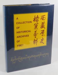
199523917London: Cultural Relics Publishing House. Near Fine in Near Fine dust jacket. 1995. Hardcover. 7501008760 . Dust-jacket protected in archival mylar cover.; No date 1995. Foreword dated October 1994. Gold papered boards with red lettering on spine and front board. Blue lettering and silver illustration on front board. Page dimensions: 285 x 213mm. "China is an ancient vast and multi-nationala caountry and as part of the Chinese nation the Tibetan people's role has developed through history." - from the Foreword. "This book is a collection of 107 photoprints of precious Tibetan historical archives seals and other cultural relics presented in Tibetan Phags-pa Mongolian Chinese Manchu and Mongolian languages" - from the Postscript. Title and preliminary pages in Chinese and English. With Chinese and English translations of the texts of the archives. . Cultural Relics Publishing House hardcover
20001063272000 Edité à compte d'auteur - 2000 - In-8, broché - 179 p. - Riche iconographie en couleurs et en N&B
89 pages. Index, bibliography, glossary. "Divides the sedges of the region into five groups by environment, provides detailed descriptsions of each, provides life-like illustrations." - from Introduction. Usual library markings. Average wear. Sound working copy. Book
220 pages. Index. Addresses these topics: Slope movement processes and characteristics; An office/field technique for recognizing landslide-prone terrain; Measure to manage unstable terrain during forestry activities; Road deactivation and revegegation of unstable terrain. Clean, bright and unmarked with very light wear. A nice copy. Book
Very minor shelfwear. ; Studies in Mediterranean Archaeology Vol. CVI: I: 1; 4to - over 9¾" - 12" tall; 44 pages
Very minor shelfwear. ; Pp 31-111; Studies in Mediterranean Archaeology Vol. CVI: I: 2; 4to - over 9¾" - 12" tall; 80 pages
Very minor shelfwear. ; Pp113-167; Studies in Mediterranean Archaeology Vol. CVI: I: 3; 4to - over 9¾" - 12" tall; 44 pages
Very minor shelfwear. ; Studies in Mediterranean Archaeology Vol. CVI: I: 4; 4to - over 9¾" - 12" tall; 44 pages