Biblio.com

2 245 résultats
1830009582Paris - 21 Quai Voltaire: Rosselin 1830. Map. Fine. Map. A fine map hand-coloured in outline folding into original marbled paper boards with title label to the front board. Boards rubbed conrners worn. The map measures 74 x 55cm and is in very good condition with the paper bright. A very good to fine copy of this rare map. Rosselin hardcover
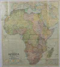
1922175918Washington D.C.: National Geographic Society. 1922. Large folding printed colour map 77.2 x 69.4 cm small inset map of Cape Verde Island note to the transliteration of place-names reference key to railways caravan routes as well as river systems waterways and deserts legend to Colonial or territorial control original folds slight toning in very good condition. Attractive large-scale map with countries and territories coloured according to the controlling colonial power. . National Geographic Society. unknown
62249Bielefeld Velhagen & Klasing 1928. . Gering berieben sonst gutes Exemplar Bielefeld, Velhagen & Klasing, 1928. unknown
58305Hamburg Deutsche Verlags-Gesellschaft D.V.G. 1912. . Außentitel "Pharus Atlas deutscher Städte". - Aachen Berlin Bremen Breslau Coblenz Cöln a. Rh. Darmstadt Dresden Duisburg Düsseldorf Frankfurt a.M. Hamburg Hannover Kiel Leipzig Lübeck Magdeburg München Stettin Stuttgart sowie Brüssel London Paris Wien. Mit illustrierten Bäder- und Kurort-Anzeigen und Führer von Heidelberg Hildesheim Osnabrück und Rendsburg von diesen Städten keine Pläne vorgesehen sowie internationalem Hotel-Register und einem Mitgliederverzeichnis des Internationalen Möbel-Transport-Verbandes. Mit einem Sonderanhang "Schweiz". Besonders interessant durch die zahlreichen schön gestalteten Anzeigen der Zeit viele davon ganzseitig. - Berieben wenig bestoßen innen nur vereinzelt etwas fleckig wenige Blätter eingerissen 1 Blatt m. großem Einriß. Hamburg, Deutsche Verlags-Gesellschaft D.V.G. 1912]. unknown
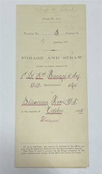
1875320963Standing Rock 1875. unbound. Partly printed military document signed 6th Infantry seven months before Little Big Horn 16.75 x 10.75 inches Standing Rock Nov. 1 1875 "A Statement Of Forage and Straw Issued to and Consumed by the Public Animals under my direction at Standing Rock Dakota Territory during the month of October 1875" for transient animals from Fort Rice signed by Captain and Commander of Post James S. Poland an officer who served under Major Reno at the Little Big Horn and was erroneously reported as "Killed In Action" when severely wounded in the back. At the time this document was signed Poland was ordered to cease his sale of rifles and ammunition to Indians at the Standing Rock Reservation as the recipients were closely connected with Sitting Bull's band. One month later the Commissioner of Indian Affairs called for the use of troops against those Indians. Also signed by Lieutenant William Badger a close friend of Custer who survived the Black Hills Campaign. His son Tom who filled out the body of this document became General Custer's personal secretary in 1876 and was killed at Little Big Horn. Also included: a Xerox of a rare photograph of the 7th cavalry 6th infantry in uniform with accoutrements all identified including Custer Badger and Poland. Partial tearing along one of the folds; otherwise near fine condition.<br/> <br/> unknown
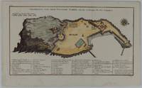
1748175859Leipzig.: Schwabe Johann Joachim. 1748. Engraved map on laid paper 20.5 x 36 cm plate -mark inc. captions 24 x 39 cm sheet size original fold later hand-colouring slight marginal spotting but in very good condition. Fine 18th century ground plan of Gorée Island off the coast of Senegal infamous for its association with slavery. The map shows encampments and forts with a detailed key. Originally published in Abbe Prevost's "Histoire générale des voyages." 1746 -1789 with maps and plans by the great cartographer Jacques-Nicolas Bellin this was prepared for volume two of the the German edition "Allgemeine Historie der Reisen." published in 1748. . (Schwabe, Johann Joachim) unknown
1823ST20595London: Longman Hurst Rees Orme and Brown 1823. Seventh Edition. 237 x 145. 9 3/8 x 5 3/4". 3 p.l. vii 1 viii 1 6-236 pp. <br/> Publisher's blue paper boards and brown paper backstrip original printed paper label EDGES UNTRIMMED AND MOSTLY UNOPENED. A Large Paper Copy. Just the faintest evidence of foxing at very beginning and very end corners with slight wear as always superficial chafing to covers but AN EXCEPTIONALLY FINE COPY the binding remarkably clean and with no significant signs of use and the wide-margined text unusually fresh and nearly as white as snow.<br/> <br/> In its original boards untrimmed and partly unopened this is a wonderful contemporary copy of an important later edition of the magnum opus of a man whose name came to be synonymous with road improvement. DNB tells us that Scottish-born John Loudon McAdam 1756-1836 was "the first systematic builder and administrator of roads in Britain since Roman times" and his impact was so great that his name lives on to the present day in connection with paved surfaces. The use of "macadam" or "macadamized" to mean a good road surface began in the 1820s and continued through the invention of the automobile when dusty roads began to be improved with tar. At first "tar" was combined with "macadam" producing the term "tarmacadam" when referring to these improved roads; eventually this became shortened to "tarmac" which still is broadly understood to refer to road surfaces and more specifically to airport runways. Our author first published "Remarks on the Present System of Road Making" in 1816 to deliver his suggestions for an improved paving method following his extensive survey of the roads of Britain. His system--in which roads were built with a cambered surface for drainage using layers of consistent sizes of stones and gravel--soon caught on both within Britain and abroad. The present seventh edition features a variety of new material much of which deals with McAdam's efforts to encourage legislation for improving roads; this includes a new preface and advertisement as well as the "Minutes of Evidence" given by witnesses regarding turnpike improvement from March to May 1819 and the report of the Select Committee of the House of Commons on McAdam's system from June 1823. As evidenced by its appearance in multiple printings McAdam's "Remarks" was a widely used book but our remarkably well-preserved copy in its publisher's boards--obviously and decidedly--was not. Longman, Hurst, Rees, Orme, and Brown unknown
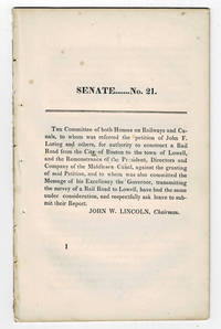
183099804<p>Boston MA: Printed by Dutton and Wentworth 1830. 1830. Very good. - Octavo 8-1/2 inches high by 5-1/4 inches wide. Softcover bound in printed self-wrappers. Once bound in with other similar pamphlets these three related items are unbound and removed with stab marks along the left edges. The pagination is a follows: pages 1-11 1 & 13-21 1-8; and 1-12. There is some scattered foxing throughout all three items. The cover page of the Senate No. 10 report dated December 15 1829 is darkened & stained with minor chipping to the bottom corners of that page and of the last page. Very good.</p><p>First edition Massachusetts Senate No. 21. The report is signed on page 11 by John W. Lincoln Chairman. The report is followed by the text of a bill entitled "An act to establish the Boston and Lowell Rail Road Corporation."</p><p>The Boston and Lowell Railroad was the first major railroad in the state of Massachusetts. The Boston and Lowell Railroad was preceded by the Middlesex Canal. Converting the canal to a railroad would eliminate the issue of transportation being unavailable during the winter when the canal froze. Patrick Tracy Jackson led the task of convincing the state legislature to fund the project. This proved difficult as the investors of the Middlesex Canal were against building a new form of transportation designed to replace their canal. The report at hand details the protest of the directors of the Middlesex Canal against granting the petition of John F. Loring and others to construct a railroad in its place. Loring and the other investors received their charter on June 5 1830 and the railroad began operations on June 24 1835.</p><p>The pamphlet is accompanied by an earlier February 12 1830 pamphlet titled:"To the Honorable the Senate and House of Representatives in General Court assembled. : The president directors and company of the Middlesex Canal having seen the publication of the petition of John F. Loring and others for a rail road from Boston to Lowell and the order of notice thereon beg leave to present the following remonstrance to granting the prayer thereof." 12 pages. Signed page 12: Wm. Sullivan Josh. Coolidge Geo. Hallet committee of directors of Middlesex Canal to this purpose duly authorized. House No. 40 printed by Dutton and Wentworth 1830.</p><p>In addition an earlier pamphlet from 1829 is included: "Boston December 15 1829. To His Excellency Levi Lincoln Governor of the Commonwealth of Massachusetts : Sir On the behalf of the Commissioners of Internal Improvements I have the honor to transmit herewith a report of a survey made in conformity to a resolve of the legislature passed on the 12th day of June 1829 directing the Board to survey a route for a rail road from the town of Taunton to some point in the route previously surveyed between Boston and Providence : with great consideration and respect I am your humble and most obe't. serv't. Josiah J. Fiske chairman." 8 pages. Signed on page 8: Josiah J. Fiske Willard Phillips James Hayward Commissioners of the Board of Internal Improvements. Senate No. 10. Printed by Dutton and Wentworth.</p> [Boston, MA: Printed by Dutton and Wentworth], [1830]. paperback
1835377678Mexico 1835. 1. plus integral blank. Signed in print by Estrada. Folio. Unbound. 1. plus integral blank. Signed in print by Estrada. Folio. A broadside decree issued by Migual Barragan giving city status to Pueblo de Nuestra Se ora la Reina de Los Angeles and naming it the provisional capital rather than Monterey. The Mexican congress declares: "The town of Los Angeles of Alta California is elevated to the rank of city and it will be from now on the capital of this territory." However representatives from Monterey would block moving the capital. <br /> <br /> "This decree was largely due to the efforts of Carlos Antonio Carrillo the deputy from California to the Mexican Congress and the author of the Exposicion of 1831" Streeter. Streeter's copy sold for $200 to Dawson's in 1968. Eberstadt 133-187; Streeter sale 2476; Rocq 4223 unknown
59049Paris. Uten Ã¥r. Stor 4to. Originalt kombinert foromslag og tittelblad. Uten tekst. Med 20 kolorerte plansjer. Aux Bureaux des Journeaux Fransk. <br/><br/><em>Colas 511. “Couvert servant de titre 20 planches gravées sur acier et coloriées chiffr 1 à 20.â€Lipperheide 1052. Bortsett fra noe slitasje i ryggstripen et pent eksemplar. </em> unknown
1827ZB311596Washington: gales & Seaton 1827. 7 pp issued as 19th Congress 2d Session S 14; extraction roughness and sewing stabs at spine previous owner's name on title age staining good only in self wrappers; one and three quarter million dollars were expended since 1811 a considerable sum at the time. - If you are reading this this item is actually physically in our stock and ready for shipment once ordered. We are not bookjackers. Buyer is responsible for any additional duties taxes or fees required by recipient's country. Washington: gales & Seaton, unknown
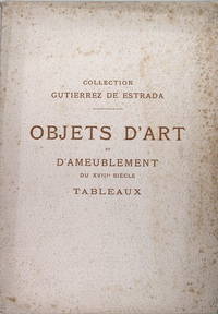
30341Gallerie Georges Petit 1905 : Paul Chevalier Mannhim Jules Feral commissaires-priseurs pour la vente du vendredi 28 et samedi 29 avril 1905. IN/4 broché. In/4 couverture remplié avec des rousseurs exemplaire non coupé 432 pages .222 références illustrations en noir. Ancienne porcelaine de Sèvre pâte tendre de chine et de Saxe. Argenterie - Objets divers - Pendules - Bronzes. Sièges couverts en ancienne tapisserie meubles en bois de plaquage - Tapisseries - Tableaux par Aved Debar Duplessis Octavien Schall etc. unknown
2001217040London.: King Road Gallery. 2001. First edition. . Decorated hard cover. . Fine copy. . Octavo. . Illustrated in black white and color. Important reference work. Very scarce in this condition. King Road Gallery. hardcover
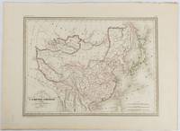
1837177519Paris. circa1837. Engraved map with original outline hand-colour 22 x 30 cm; 28.8 x 38.6 cm sheet marginal repair to the lower corner not affecting the map sheet lightly age-toned in very good condition preserved in a window mount. Fine map of China Japan and Central Asia noting Manchuria "Mandchourie" bordering Northern India and Turkestan in the West and Russia "Russie d'Asie" in the North. <br> <br>From the estate of the late collector and scholar Arthur Hacker with his pencilled catalogue mark on the verso. . unknown
20072081502111901658old books in shanghai 2007. Soft Cover. Fine. Size: A5 Soft Cover Book old books in shanghai paperback
19822092902141202343Shanhai shoten 1982. Soft Cover. Fine. Volume: 1 Shanhai shoten paperback
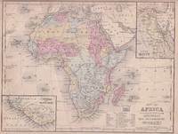
1869176603Philadelphia.: E. H. Butler. circa1869. Lithographed map with original hand-colour 21.2 x 27.6 cm two inset maps of Liberia and Sierra Leone; and Egypt showing the Suez Canal text and engravings for an unrelated entry on the verso; margins dusty top edge worn with small edge tears one affecting the border and marginal chip but in good condition. Detailed map of Africa before the escalation of colonial acquisition in the 1880s. . (E. H. Butler). unknown
18462090502128300687Not Available 1846. Soft Cover. Fine. The book is in fine condition. Not Available paperback
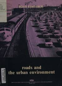
a619841969 OECD. Octavo 210pp. buckram hardcover. Ex-university library. VG text clean no DJ. hardcover
193872459Chicago: Rand McNally & American Hotel Register Co. 1938. First edition of this merging of two American atlases. Folio 10 1/2 x 16 inches. The Rand McNally section is pp. 1-52 at the beginning and pp. 52-105 at the end. All maps printed in blue and red. The Leahy section starts in the middle and runs from p. 1 to p. 112 and with two more pages. These maps are entirely printed in black and much of the section is take up with listing for hotels in various states. Publisher's green cloth with gilt cover lettering Leahy's. The text block was originally stapled into the covers but has since come loose from the staples but the text block is entirely secure. A very good copy of an unusual publication.As both companies were headquartered in Chicago it is easy to imagine a friendly lunch at which this was discussed. Rand McNally & American Hotel Register Co. hardcover
Z1-N-007-00593sold by OECD Publications Center. Used - Good. Ships from UK in 48 hours or less usually same day. Your purchase helps support Sri Lankan Children's Charity 'The Rainbow Centre'. Ex-library so some stamps and wear but in good overall condition. 100% money back guarantee. We are a world class secondhand bookstore based in Hertfordshire United Kingdom and specialize in high quality textbooks across an enormous variety of subjects. We aim to provide a vast range of textbooks rare and collectible books at a great price. Our donations to The Rainbow Centre have helped provide an education and a safe haven to hundreds of children who live in appalling conditions. We provide a 100% money back guarantee and are dedicated to providing our customers with the highest standards of service in the bookselling industry. [sold by] OECD Publications Center unknown
195676405San Jose: H.M. Gousha Co. on or before 1956. First edition of this gathering. Folio 13 1/4 x 18 inches. 62 unused road maps in color and with inserts each neatly divided by side tabs. All maps bound on stubs. Original red cloth portfolio with flap and snap fasteners the Shell logo stamped on front cover some soiling or darkening to extremities. The portfolio has some expected wear but the maps are fresh and clean. Shell maps of this era are notable for their high-quality cartography colorful graphics and often included travel tips local advertisements and information about Shell services. None located by OCLC. Harry Mathias Gousha a former Rand McNally went independent in 1926 and relocated to California in 1947. It was a propitious time as the 50s in most respects witnessed the onset of the great American phenomenon of the Road Trip. With the improvement in cars longer and longer trips became feasible. None of the great Interstates as we know them today were in existence at that time so road maps were essential for any successful road trip. The H.M. Gousha Company was one of the "Big Three" major producers of road maps and atlases in the United States during the 25 years following World War II General Drafting and Rand McNally were the other two. Shell maps of this era although free are notable for their high-quality cartography colorful graphics and often included travel tips local advertisements and information about Shell services. The H. M. Gousha Company produced millions of oil company road maps used as marketing tools distributed at no charge at gas stations by customers that included Gulf Oil Conoco Shell Standard Oil and dozens of others. Though most Gousha maps were produced for oil companies many others were issued for customers not related to the petroleum industry including automobile clubs state governments banks and realtors. Ironically the company was purchased by Rand McNally in 1996. H.M. Gousha Co. hardcover
51860Leipzig Georg Joachim Göschen 1830. . Verlags-Bibliographie Göschen 1785-1838 Nr. 1027. Vgl. Studien zur Verlagsgeschichte u. zur Verlegertypologie der Goethezeit S. 190. - Einband stark beschabt Textteil gebräunt/stockfl.; erste Karte gebräunt sonst nur gelegentlich stockfleckig im weißen Kartenrand. - Allgemeine Übersicht. Topographie der vorzüglichsten Orte von A-Z. Grenzkolorierte Karten von Königreiche ENGLAND SCHOTTLAND u. IRLAND; Gibraltar Malta Helgoland Ionien; die Kolonien: Britisch-Ostindien Kap-Kolonie Westindien afrikanische Westküste Goldküste Guinea Mauritius St. Helena Nordamerika Hopparo Britisch-Guyana Australien. - Der königlich sächsische Kammerrat W. E. A. v. Schlieben 1781-1839 Statistiker u. Oberlandfeldmesser war Mitbegründer des Statischen Vereins in Sachsen 1831-1850 u. Leiter des Zentralkomitees des Vereins. Leipzig, Georg Joachim Göschen, 1830. unknown
20162081502111900300Chinese book office 2016. Soft Cover. Fine. Number of pages: 367p Chinese book office paperback
20062092902141204738beijing library 2006. Soft Cover. Fine. Volume: 1 beijing library paperback