[QINGDAO IN 1938].Biblio.com
4 345 résultats
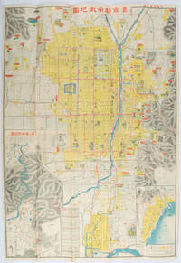
1572171093Qingdao: Taiheiyoko. 太平洋行. 昭和 13 1938. Coloured folding plan of Qingdao in 1938. some browning on reverse with a small lighter section on map Japanese place names no scale 36 x 39cm 3 inset maps. This 1938 Qingdao city map shows street names in Chinese characters and location of Chinese and Japanese public buildings such as the hospital shrines Japanese primary schools and high schools. The 3 inset maps show railway and transport routes as well as outskirts of the city. . [Taiheiyoko]. 太平洋行. unknown
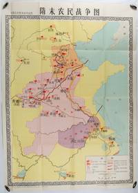
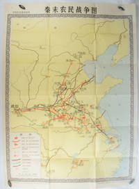
1980176714北京. Beijing.: 地图出版社.Di tu chu ban she. 1st Edition 1st Printing. 1980. Large Chinese education map folded with original envelope scale 1:1500000 legend left lower corner showing the military advance routes and battle grounds led by several leaders of the agrarian rebels including 王薄 Wang Bo 窦建德 Dou Jiande 杜伏威 Du Fuwei and 翟让 Zhai Rang. Very good copy. <br> <br>Text in Chinese. Sheet measures 106.8 x 76.52cm. . 地图出版社.[Di tu chu ban she]. unknown
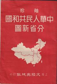
1952215851大陸輿地社. 1952. Charming pocket size atlas with double page coloured map showing China as a whole and the provinces with inset maps of special geographical features and a description of key information about each province vertical text. Text in traditional Chinese characters names on map read from right to left or vertically. Light wear little light browning but maps very clean and bright very good condition 14.5 x 9.8cm. . 大陸輿地社. unknown
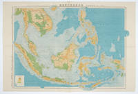
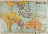
1572160538東京.Tokyo.: 日本名所圖繪社.Nihon Meisho Zuesha. 昭和16 1941. Folding colour Japanese map of the Malay Archipelago and Thailand scale 1: 8500000 with attractive original pictorial paper envelope. This map also shows the Dutch French and American colonies. Hainan Province and the South China Sea are shown in the north. Agricultural and mineral resources indicated across the map. Few small holes at holes and other light signs of wear. Slipcase lttle torn. Text in Japanese and English. 53.3 × 78.2cm. . 日本名所圖繪社.[Nihon Meisho Zuesha]. unknown
1572160533Tokyo.: 日本名所圖繪社.Nihon Meisho Zuesha. 昭和 17 1942. Folding Japanese coloured map of the Malay Archipelago and Thailand during World War II scale 1:8500000. Legend in lower corner indicates altitudes. Ink annotation in Japanese left edge. Pin holes at three corners upper right corner torn with loss evenly browned otherwise very good. Text in Japanese and English. 52.8 x 75.6cm. This map shows most of Thailand former Indochina Hainan Province and South China Sea Sumatra and Java Sea Borneo the Philippine Islands Celebes Timor New Guinea and parts of Micronesia. Natural resources such as tobacco spices wood sugar metal mines tin iron and etc. rice and other resources are indicated on the map. . 日本名所圖繪社.[Nihon Meisho Zuesha]. unknown
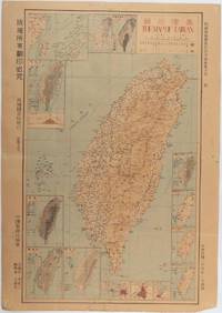
1945215871Taiwan.: 禹甸圖書局. Yudian tushuju. 1945. 1945 Ministry of Interior map of Taiwan published in the 34th year of the Republic of China with inset title and key top right. Romanised Japanese names for some areas and cities written in capital letters on main map which is surrounded by 15 small inset maps at edges each with its own scale. Paper browned wear at folds and edges repaired with archival washi on reverse some light stains and a few marks. 1 x 3cm chip bottom right corner. 77.4 x 54 cm. Text in traditional Chinese characters. Inset maps show clockwise from right edge; 1. Distribution of inhabitants according to ethnic background or minority group 2. Qing Dynasty prefectures and counties 3. Japanese administrative regions during the occupation 4. Strategic industrial and military places three city maps - 5.Chilung or Keelung port 6. Taipei city and 7. Tainan city 8. Geological formations 9. agricultural metallurgical and mineral products 10. Soil types 11. Topography of the island including sea currents and altitude diagram 12. Taiwan's position in relation to the mainland coast provinces of Fujian and Zhejiang as well as the Liuqiu Ryukyu Islands including Okinawa 13. Okinawa detail 14. Climate and rainfall in January 15. Climate and rainfall in July. . 禹甸圖書局. [Yudian tushuju]. unknown
1955172396No publication details. Circa1955. Chinese black and white military map of Japan based on a map issued by 赤旗報 Shimbun Akahata on 24 June 1953. No scale given inset map of Hokkaido upper left corner legend lower section showing air and navy bases military exercise bases ammunition dump shooting ranges for the air force and navy headquarters of the coast guard etc. Text upper section provides details of the different types of US military bases and infrastructure. Text in traditional Chinese. 25.8 x 35.8cm. . No publication details. unknown
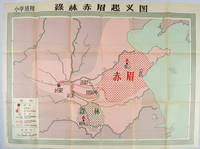
1958171563Beijing.: 地图出版社. Di tu chu ban she. 1st Edition 2nd Printing. 1958. Large Chinese coloured educational map folded. Scale 1:2000000 legend lower left corner showing the military advance of two peasant insurgent groups Lulin and Chimei's march towards the capital city Chang'an now Xi'an in 17 AD. In original worn paper wrapper map in very good condition. Text in traditional Chinese. Map measures 77 x 105.2cm. 王匡 Wang Kuang and 王凤 Wang Feng founded the Lulin Army in the region of modern Hubei Province. 樊崇 Fan Chong lead the Chimei also known as Red Eyebrows Army in the northern parts of modern Shandong Province. . 地图出版社. [Di tu chu ban she]. unknown
1981173280Beijing.: 地图出版社. Di tu chu ban she. 1st Edition 2nd Printing. 1981. Large Chinese coloured educational map folded scale 1:2000000. Legend lower left corner shows the routes of military advance led by peasant rebellion leaders' 陈胜Chen Sheng and 吴广Wu Guang in red and other military activities led by 项羽Xiang Yu and 刘邦Liu Bang in various colours. In original worn paper wrapper map in very good condition. Text in Chinese. Map measures 105.5 x 76.6cm. . 地图出版社. [Di tu chu ban she]. unknown
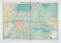
1572159290東京.Tokyo.: 金鈴社. Kinrei-sha. 昭和十八 October 101943. Two maps printed in colour on a single side of a folded sheet. The map titled "Complete Map of India and Australia" shows the region covering Australia southern India western mainland south-east Asia Indonesia the Philippines and New Guinea. The other map titled "India and Burma" shows the region covering India Afghanistan the western section of China Burma and Thailand on the lower left side. New Zealand is in an inset map in the lower right corner. As the note on the cover says "Including the detailed descriptions of the Solomons New Guinea and southern islands" this map shows the theatres of the Pacific War and the surrounding areas. The map indicates agricultural and mineral resources as well as cities roads railways sea routes national borders etc. Cover and publication details printed on two panels on the reverse. Some marking and browning. . 金鈴社. [Kinrei-sha]. unknown
1572172829大阪. Osaka.: 大阪毎日新聞社. Osaka Mainichi Shinbunsha. 昭和 13 1938. Black and white map folded showing Hankow one of the three cities which merged to become Wuhan 54.5 x 49cm scale 1:2000000. Some light browning tiny closed tear upper margin neatly repaired with conservation standard tape. Good copy. This Hankow/Hankou War Situation Map is a supplement map of Osaka Mainichi Newspaper on 25 August 1938. The two inset maps show the region around Nanjing and Hong Kong. It gives detailed place names of Hankow area. . 大阪毎日新聞社. [Osaka Mainichi Shinbunsha]. unknown
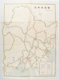
1519172590奉天. Mukuden.: 満鉄鉄道総局. Mantetsu Tetsudo Sokyoku. 昭和 15 1940. Colour folded map seven small very holes not affecting the printed image otherwise good. 53 x 38.5cm Map showing the comprehensive railway network in Manchuria with names of all the stations. It includes the lines run by the South Manchurian Railway Company their temporary industrial lines light rail as well as the lines run by other Russian and Chinese companies. By 1940 the network had expanded so much that it included almost the whole of Manchuria. . 満鉄鉄道総局. [Mantetsu Tetsudo Sokyoku]. unknown
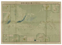
1819155215統正社 Tōseisha . Showa 18 1943. Colour folded map 54. x 76.5cm. Pinholes at corners light even browning good copy. This Japanese map of Micronesia shows the Mariana Islands Eastern and Western Caroline Islands Marshall Islands and Gilbert Islands. The separate maps around the edge are clockwise from the upper right corner: Jaluit Atoll Guam Island Rota Island Saipan Island Palau Islands Yap Island Hall Islands Pohnpei Island Truk Islands and Kusaie Island. . 統正社 [Tōseisha ]. unknown
1819162103Tokyo.: Tōseisha. Showa 18 1943. Folding colour map of Australia 54.2 x 76.4cm. Some foxing particularly along folds and upper right margins a few repaired tears and small holes at folds.With original sleeve. The 15th map in the Standard Maps of Greater East Asia series of 20 maps. Shows the natural resources such as sheep gold pearl diary regions opals etc. Tasmania appears as an inset in the bottom right corner. Text in Japanese. . Tōseisha. unknown
1572160554Tokyo 東京: 統制社Tosei-sha. 昭和 Showa 18. 1943. Colour folding map 54 x 75.5cm with original envelope. Envelope a little torn some occasional browning very good. The 13th map in this Standard Maps of Greater East Asia series of 20 maps. All text in Japanese. Shows railways shipping routes administrative boundaries airfields ports lighthouses mines oil wells etc. . 統制社(Tosei-sha) unknown
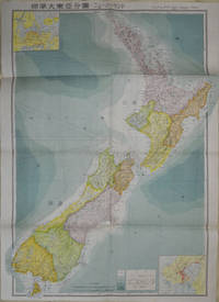
1572154080Tokyo: 統制社Tosei-sha. 昭和18 Showa1943. Folding colour map of New Zealand with inset of Auckland and Wellington top and bottom corners1:2000000 scale little light browning. Original envelope worn with closed tears. 54 x 76.5cm. Good copy. Scale plan of New Zealand printed by Tosei in 1943. The map legend shows infrastructure deemed important to the Land Survey Bureau of the General Staff Headquaters of the Imperial Japanese army such as boundaries powerlines quarries and mines; railroads sea-routes etc. . 統制社(Tosei-sha) unknown
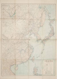
1419160524Tokyo.: 大日本帝國陸地測量部. 昭和14 1939. Large colour folding Japanese WWII map. Scale 1:5000000 featuring Japan Korea Taiwan Karafuto Eastern China parts of French Indochina and the Northern Philippines US colony in detail. Legend includes territorial boundaries national and regional and shows some borders as unclear i.e. Taiwan and bordering region along Northeast China the Soviet Union and Mongolia air routes submarine communication cables linking major costal cities i.e. Hong Kong Xiamen Shanghai Nagasaki etc. airports radio stations mining fields and more. A small chart shows the names of mountains rivers and lakes also included adjacent to legend. Some small holes at folds creases and some minor loss edges generally very good. Text in Japanese. 109 x 77.8cm. . 大日本帝國陸地測量部. unknown
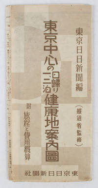
1419163423東京日日新聞社. Showa 14 19391939. Title on map :東京中心の健康地案内鳥瞰圖. Tōkyō chūshin no kenkōchi annai chōkanzu. <br>Colour map of region around Tokyo with inset map in lower right corner. Few closed tears along central fold larger tear repaired small holes at folds a little light browning. Measures 19.5 cm x 9.5 cm when folded and 38.7 cm x 54 cm when open. Bird's eye view map of the region around Tokyo showing places where the residents of the city can go for healthy one two or three day trips. The map published by the Tokyo Nichi Nichi Newspaper in 1939 highlights hot springs golf courses beaches parks fishing areas mountains shrines and ski areas. The mark ハ indicates hiking courses. On the reverse side the distance to each resort area the way to get there and the costs are detailed. Users of the map area are warned that the areas circled in red around the mouth of Tokyo Bay is a military area where photos cannot be taken without permission. Even with the rising tides of war in 1939 city people were clearly still looking for ways to escape the noise and dust of the city for health-giving recreation. . 東京日日新聞社. unknown
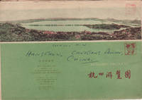
1962160933杭州.Hangzhou.: 浙江人民出版社.Zhejiang renmin chu ban she. 2nd Edition 3rd Printing. 1962. Folding colour tourist brochure for Hangzhou. One side shows large map of Hangzhou the other 5 more detailed maps chops and previous owner's annotations upper cover small hole at one fold some light wear and browning good. Text in both traditional and simplified Chinese. Sheet size 53.9 x 38.3cm folded size 13.5 x 19.2cm. <br> <br>One side includes a legend an inset showing tourist spots surrounding Hangzhou a table shows lists of Hangzhou's hospitality industry e.g. hotels cinemas swimming pools restaurants department stores etc. The other side includes five individual tourist maps: Viewing Fish at Flower Pond 花港觀魚 Lingyin Temple 靈隱 Hangzhou Bus Map 杭州市公交路线图 Lonely Mountain 孤山 Dreaming of the Tiger Spring 虎跑. . 浙江人民出版社.[Zhejiang renmin chu ban she]. unknown
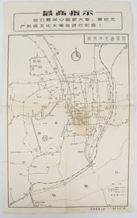
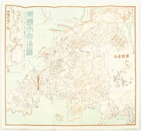
19671632381967. Vintage transportation black and white map of Hangzhou folded no scale a legend lower right corner shows bus/trolleybus routes and terminals. The map covers the old city of Hangzhou from the north side of the city 杭三中"Hangzhou No.3 High School" to the south side 钱江大桥 "Qiantang River Bridge". The West Lake is featured in the centre with its famous tourist spot 三潭映月 "Three Pools Mirroring the Moon" indicated. Bus/trolleybus routes connects schools hospitals municipal government departments cinemas department stores tourist spots around the West Lake etc are all shown on this map. <br> <br>Stained in the central section light wear along folds and edges otherwise good. Text in Chinese. Sheet measures 39.1 x 24.8cm The headline Chinese text in the box along the top of the map reproduces one of the highest directives from Mao's Quotations: "You must pay attention to state affairs and carry the great proletarian cultural revolution through to the end!" . unknown
1419171112東京. Tokyo.: 伊林書店. Ibayashi Shoten. 昭和14 1939. Colour printed folding map 78 X 109cm minor damage original envelope 27.5 x 20cm. Very good copy. This map offers comprehensive information on northern China Manchuria the Soviet Union and Hokkaido including Kuril Islands under the Japanese control. It also includes the Jewish Autonomous State which existed in the late 1930s. The inset map provides detailed information on the border area of Japan Manchuria and the Soviet Union. Legends include national borders railways major cities iron mines and oil wells. <br> <br>Published in 1939 this map is an expression of the tension Japan felt in its relationship with the Soviet Union. At the time the Soviet Union was seen as the mighty threat to the lying just north of Manchuria and Japan . . 伊林書店. [Ibayashi Shoten]. unknown
1938159295Tokyo: 大日本雄辯會講談社 Dainihon Yūbenkai Kōdansha. Shōwa 13. 1938. Two large detailed maps of China and on the reverse of the Soviet Union in Asia Manchuria and Mongolia printed double sided on a single large sheet. Issued as a supplement to Volume 14 Number 1 of the magazine Kingu on New Year's Day in 1938. <br> <br>Holes at a number of holes causing a small amount of loss some occasional browning some chipping on margins. The map has clearly been used but is still largely complete. The colourful map of China on a scale of 1:2600000 includes part of Manchukuo and Inner and Outer Mongolia on the north and part of French Indochina to the south-west. It shows East Hebei Autonomous Anti- Communist Council Jidong Fanggong Zizhi Zhengfu 冀東防共自治政府 south of Manchukuo which existed from late 1935 until February the 1st1938. The legend includes national and provincial borders cities roads railways sea and air routes and undersea cables. There is an inset map of East Asia titled "Present Situation of Far East" on the lower right corner which shows the areas under influence of Communism and those under influence of/controlled or colonised by the United Kingdom France Japan and China. <br> <br>The map on the reverse printed in blue and black shows the Asian section of the Soviet Union Manchuria and Mongolia on a scale of 1:3000000. There is an inset map of Asia titled "Asian Continent" at the upper left corner the area enclosed by a rectangle which indicates the area covered in this map. The legend includes cities railways roads national borders district borders province borders and air routes. . 大日本雄辯會講談社 [Dainihon Yūbenkai Kōdansha]. unknown
1922171899京都. Kyoto.: 山中書房. Yamanaka Shobō. 大正 11 1922. Attractive colour folding map of Kyoto with a quite detailed illustrated tourist guide printed in blue and white on the reverse some light browning holes at some folds good copy. 78.5 x 54cm This 1922 colour folding tourist map of Kyoto offers sightseeing information each panel showing a photographic monochrome image of the site discussed. <br> <br>The two inset maps on the Kyoto map show Otsu city on the shore of Lake Biwa and the Arashiyama area north of Kyoto. The main map highlights the major temples and famous sights in red geographic features such as rivers and hills are shown and an inset chart shows distances of sights from the nearby stations. The information on the reverse gives more detail on the famous sights a calendar of events seasonal highlights and details of the Imperial graves around Kyoto. . 山中書房. [Yamanaka Shobō]. unknown
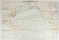
169329東京. Tokyo.: 九段書房.Kudan shobo. 大正十四 1925. Coloured folding Japanese map showing the military strength of Japan the United States and the United Kingdom in the Pacific original pictorial envelope scale not given. Some small holes at folds occasional light foxing a prior owner's signature on reverse minor wear envelope. Very good copy in like envelope. Map measures 54.4 x 78.8cm. The explanatory text in Japanese printed on the reverse in blue summarises the colonial possessions of the US and the UK as well as providing a comparison between the land size naval presence natural resources immigration issues and maritime transport capacities of Japan the United States and the United Kingdom. Legend indicates national regional provincial territorial boundaries canals undersea cables airline routes metropolitans capital cities mining fields hot springs ancient battle fields major trade ports Japanese embassies and consular offices. A large area marked 日本委任统治 "South Pacific Mandate" highlighted in a box is adjacent to Australian occupied Papua New Guinea. . 九段書房.[Kudan shobo]. unknown
2008169215北京.Beijing.: 星球地图出版社.Xing qiu di tu chu ban she. May2008. Two large coloured maps printed on double sided on a single sheet folded issued shortly after the devastating 2008 Wenchuan Earthquake which was occurred on 12 May 2008. Small tears along folds mended by both non-acidic tape and cello tape some creasing generally good. Text in Chinese. Sheet measures 84.9 x 119.7cm. <br> <br>Map of Sichuan Province: scale 1: 1100000 inset map lower right corner showing the provincial capital city Chengdu a statistical chart lower section listing counties within Sichuan Province their population and territory size. <br> <br>Map of Wenchuan County and Its Vicinity: 1: 300000 various colour representing altitude differences inset map showing the position Wenchuan County within Sichuan Province a mileage chart listing the distance between Wenchuan County to nearby cities. A brief introduction of Wenchuan on left section accompanying the images of the rescue forces. The Great Wenchuan Earthquake was the biggest earthquake in Chinese history with a casualty over 69000 people. . 星球地图出版社.[Xing qiu di tu chu ban she]. unknown