1 203 résultats
1623LD8073London: Printed by John Beale for George Humble 1623. Second edition. Hardcover. Very Good. Folio 340 x 220mm. xx 1258pp. 74 numerous error in paging and register. Signatures: par.6 1st leaf blank A8; B-2H6; I4; 2K-4S6; 4T4; 4V-4Y6; 4Z8 4Z8 sic 4Z4; 5A-5T6; 5V1 of 4. Printers device of Humble on title head- and tail- pieces and initials throughout. Many in text engravings including 8 full page genealogies and numerous woodcuts throughout of coins and seals. Text in double column. Period full English calf rebacked and restored at corners in modern leather and stamped in gilt Historie of Great Britain Speed; lacking frontis. title somewhat browned and remargined text block lightly browned around edges lacking final 3 leaves of Table otherwise good. Sold as is. Large white on black bookplate of Dr. Otto Orren Fisher of Detroit Michigan to front pastedown. <br/><br/>Second Edition of Speeds Historie of Great Britain. Second Edition revised and enlarged and reissued in 1625 and again in 1627; Speeds Historie of Great Britain was originally published in 1612 with The Theatre of the Empire of Great Britaine as a companion volume though continuously paginated The Historie being the second work and the contents listing refers to the first four books which were part of the Theatre although this work books 5 - 10 is complete in itself. His account of the reign of Henry VIII p. 998 is followed by an appendix described in the running head as A Catalogue of the Religious Houses Colledges and Hospitals sometimes in England and Wales. These sections hold a wealth of information on early successors and founders of English Institutions. It was likely Speed an apt historian himself borrowed many of his materials from William Camden and was supplied by many Sir Robert Cotton Sir Henry Spelman and other antiquaries with whom he was acquainted. Although he probably had access to historical sources that are now lost to us he certainly used the work of Saxton and Norden his work as a historian is considered mediocre and secondary in importance to his map-making and the town plans he drew. Despite its many defects the Historie was very frequently cited by later writers. An important rich historical and artifactual book on Early English history. STC 2nd ed. 23046.3 Printed by John Beale for George Humble hardcover books
16279025633London: George Humble 1646 and 1627. Hardcover. Very good. Two works in one volume. Oblong octavo measuring 6 1/4 x 3 7/8 inches 16 x 9.75 cm.Rebound in full brown pebbled morocco with new tan endpapers. With custom made drop back folding clamshell slipcase in complementary tan cloth with leather spine labes stamped in gilt. First part with engraved title plus 19 engraved maps as called for. Second part with engraved title bound in upside down and remargined; Sixty - four maps called for in the index. Lacks map of England Scotland and Ireland1 and final map entitled MIDIA 64. Yorkshire map is missing section folded in from fore edge. 81 maps of 83 called for PLUS two engraved title pages. Some interior stains and foxing but still quite acceptable. A series of images is available on request. <br/><br/> George Humble hardcover books
1626273459London: George Humble 1626. unbound. Map. Engraving with hand coloring. Image measures 15.25" x 19.75".<br/><br/> This beautiful carte a figures map of Tartary by John Speed presents the many geography speculations found at a time when parts of Asia were largely unexplored by Europeans. Extends from Armenia eastward to include part of North America and includes the Arctic Sea and Nova Zembla.<br><br>Korea is presented as an Island while the Kamchatka Peninsula is entirely absent. The Straits of Anian believed to be associated with the mythical Northwest Passage is identified. The Great Wall of China is depicted in a grand style south of which lies the Kingdom of China. Throughout several kingdoms important cities rivers lakes islands mountains and other topographical features are noted. These includes important cities which were part of the ancient Silk Route.<br><br>The Caspian Sea presented along its East-West Axis according to the practice of the time is identified by various names Sea of Sala otherwise Bachu called by the Russians Chualenske More in old time the Caspian and Hircan Sea. Further north Tazota Island from the Roman geographer Pliny the Elder appears in the Arctic Circle.<br><br>Beijing or Peking appears north of the Great Wall and is identified by the name Cambalu as used my Marco Polo. Interesting notations are also included throughout including one north of the Great Wall reading "In this Country is a hil out of which they dig earth called by Pliny terra Asbestus having fine veines like grasse which being spun and weaved yeeld cloth that wil nut burn in the fire".<br><br>The map is surrounded on the left and right with illustrations of the costumes and people from various parts of the region. Along the top border four views are included detailing the cities Astrakan Samarkand Cambalu and a view of the house of Nova Zembla.<br><br>Engraved by Dirck Grijp. Appears in Speed's important "Prospect of the Most Famous Parts of the World". The map is in good condition with some wear along the original centerfold. Overall foxing and some tape residue long the top margin from framing. Very good impression. English text verso.<br><br>John Speed 1552-1629 is widely considered to be the most famous English cartographer of the 17th century. His atlas "The Theatre of the Empire of Great Britaine" contained the first set of individual county maps of England and Wales as well as significant town plans that are in many cases the first visual records of their subjects. This important map of Asia is a wonderful example of his work.<br/><br/> George Humble unknown books
1953033292London: Penguin Books 1953. Forty plates from John Speed's pocket atlas of 1627. Introduced and described by E. G. R. Taylor. 31 1p. plus 40 colored illus. original stiff printed boards King Penguin books 61. Penguin Books unknown books
1610247261Sudbury & Humble 1610. Map. Engraving with hand coloring. Image measures 15 x 20".<br/><br/> This wonderfully decorated map depicts the island of Anglesey off the northwest coast of Wales. The island is centered on the map and labeled with towns rovers as well pictorial mountains and trees. A strapwork title cartouche features the coat of arms of England flanked by a lion and a unicorn. Below two elegant ships sail the beautifully patterned ocean surrounding an elaborate and colorful compass rose. In the lower left corner of the map showing part of Wales is an ornamental scale topped with strapwork cherubs a peacock and the country's coat of arms. A similar border frames the inset of Beaumaris in the upper right of the map which shows a plan of the port city labeled according to a key including its famous castle. The map appeared in Speed's atlas "The Theatre of the Empire of Great Britaine." It is in good condition with but margins are cropped. Expert repair to right corners. John Speed 1552-1629 is widely considered to be the most famous English cartographer of the 17th century. His atlas "The Theatre of the Empire of Great Britaine" contained the first set of individual county maps of England and Wales as well as significant town plans that are in many cases the first visual records of their subjects. This map of Anglesey is a beautiful example of his work.<br/><br/> Sudbury & Humble unknown books
1627273306London: George Humble 1627. unbound. Map. Engraving with later hand coloring. Image measures 15.25" x 20".<br/><br/> This fascinating 1627 map of Asia by John Speed is the first British map of Asia. The map presents the entire continent from the Mediterranean east to include Japan and the East Indies. The map presents many speculations and common conventions found at a time when parts of Asia were largely unexplored by Europeans.<br><br>Korea is presented as an elongated peninsula while the Kamchatka Peninsula is entirely absent. The map shows Japan and a fairly detailed depiction of the East Indies. Further west the Caspian Sea is presented along its East-West axis as per the practice at the time. The Great Wall of China is depicted in a grand style. Throughout several kingdoms important cities rivers lakes islands mountains and other topographical features are noted.<br><br>One of the most interesting cartographic feature on this map is the appearance of Lake Ciamay or Lake Chiamay near northeast India. This mythical lake appeared on maps from the 16th to late 18th century and was believed to be the source of the great rivers of Southeast Asia.<br><br>Illustrations of ships and sea monsters are included. The map is surrounded on the left and right with illustrations of the costumes and people from various parts of the continent. Along the top border eight city views are included detailing Candy Goa Damascus Jerusalem Ormus Bantam Aden and Macao.<br><br>Engraved by Abraham Goos 1590 - 1643 a master engraver was the son of Pieter Goos and Margareta van den Keere which were both from map families. Appears in Speed's important "Prospect of the Most Famous Parts of the World". The map is in good condition with some wear and verso repair along the original centerfold. Overall foxing and narrow margins. English text verso.<br><br>John Speed 1552-1629 is widely considered to be the most famous English cartographer of the 17th century. His atlas "The Theatre of the Empire of Great Britaine" contained the first set of individual county maps of England and Wales as well as significant town plans that are in many cases the first visual records of their subjects. This important map of Asia is a wonderful example of his work.<br/><br/> George Humble unknown books
1954223986London: Phoenix House Limited 1954. First edition. Illustrated. 3 vols. Folio. Three-quarter cloth patterned boards paper labels. Near Fine 3 in slipcases. First edition. Illustrated. 3 vols. Folio. Phoenix House Limited unknown books
279246George Humble. First. unbound. Miniature Map. Engraving. 3 1/4" x 4 1/4"<br/><br/> Rare undated first edition of John Speed's map of Middlesex County from "Theatre" in miniature. Includes lovely rendering of London. John Speed 1552-1629 born in Cheshire and a tailor by profession until he was 50 is widely considered to be the most famous English cartographer of the 17th century. He is noted for placing England in the mainstream of map publishing an industry which was at the time dominated by the Dutch. His atlas "The Theatre of the Empire of Great Britaine" contained the first set of individual county maps of England and Wales as well as significant town plans that are in many cases the first visual records of their subjects.<br/><br/> George Humble unknown books
163230290London: John Dawson for George Humble 1632. Folio pp. 22 1237 i.e. 1281 - page numbers 1043-1086 assigned to recto only 85; includes the preliminary blank leaf; engraved frontispiece portrait of Speed by S. Savery numerous woodcut illustrations and genealogical tables throughout; numerous woodcut initials and ornaments; contemporary full calf perfunctorily rebacked in brown calf maroon morocco label on spine; several clean tears entering text no loss leaf 5a with small piece missing from fore-edge causing minor loss to a few words and numbers light occasional dampstains; a good sound complete copy. A continuation of his Theatre of Great Britaine whose contents are described in this volume as The Chorographicall Part accounting for the first 4 books. This volume The Historicall Part therefore begins with "the fifth booke" but is complete in itself. STC 23049; Graesse V 462-63; Lowndes 2471-72. <br/><br/> John Dawson, for George Humble unknown books
1611956London: John Sudbury & George Humble; John Dawson for George Humble 1611. 1st Edition. Hardcover. Very Good. THE EARLIEST ATLAS OF THE BRITISH ISLES AD THE EARLIEST WORLD ATLAS BY AN ENGLISHMAN. FIRST EDITION of "The Theatre"; 1611 bound with the second edition 1631 of the "Prospect" "The Theatre of the Empire of Great Britaine. was the earliest English attempt at producing an atlas on a grand scale with the first detailed maps of the provinces of Ireland the first set of county maps consistently attempting to show the boundaries of territorial divisions and the first truly comprehensive set of English town plans-a notable contribution to British topography. Perhaps as many as fifty of the seventy-three towns had not previously been mapped and about fifty-one of the plans were probably Speed's own work. A balance is struck between the modern and historical with information placed on the edges of the maps about antiquarian remains and sites and vignettes of famous battles together with arms of princes and nobles. This additional information is one of the Theatre's most significant contributions" Dictionary of National Biography. The "Theatre" is complete with engraved architectural title engraved Royal Achievements by Jodocus Hondius dated 1611 letterpress list of kingdoms and woodcut royal arms three letterpress section titles with woodcut borders three woodcut royal arms 67 double-page engraved maps most by Jodocus Hondius woodcut head- and tail-pieces and initials mounted on guards throughout. The "Prospect" was intended as a supplement to the "Theatre" and includes 22 maps of different parts of the world including the famous world map presumably by Abraham Goos and the map of America both showing California as an island. With engraved portrait frontispiece bound before "Theatre". NOTE: The "Prospect" is lacking "Invasions" but with 'Canaan' bound in its place and lacking the final text leaf on 'Civill Warres'. Also with portrait trimmed to platemark and laid down. Provenance: J.B. Speed Art Museum Louisville Kentucky bookplate. London: John Sudbury & George Humble; John Dawson for George Humble 1611; 1631. Folio 414x287mm 19th-century full calf with elaborately gilt-decorated spine. Joints repaired small chip to label. Some offsetting including on the world map some marginal repaired closed tears some maps closely cropped. Most maps including the world map with good strong impressions. John Sudbury & George Humble; John Dawson for George Humble hardcover books
697206639Packt Publishing Limited pp. 212 Index. Papeback. New. Packt Publishing, Limited unknown
186532612Washington 1865. 16pp disbound light rubberstamp Good.<br/><br/> Speed was a Kentuckian appointed as Lincoln's Attorney General in 1864. Though a Border State moderate he quickly became an all-out Union man with the outbreak of war. Here he opines that trial of the alleged presidential assassins should occur by military commission rather than civil courts: the law of war as part of the law of nations has implicitly been adopted in the Constitution. "When lawless wretches become so impudent and powerful as not to be controlled and governed by the ordinary tribunals of a country armies are called out and the laws of war invoked." The laws of war do not require different treatment of "secret active enemies" and "open active enemies" who would be tried by military tribunal. Under these circumstances the alleged assassins may be tried by military court without a jury. <br/>FIRST EDITION. Monaghan 739. II Harv. Law Cat. 634. Not in LCP. unknown books
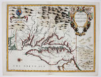
16769394London 1676. No Binding. Near Fine. 14 3/4 x 19 ¼ inches. Fine hand color; wear to bottom of centerfold else fine condition. A very attractive near-mint example. Speed's handsomely engraved work is one of the earliest English maps of the area and one of the first to demarcate the borders of colonial Virginia and Maryland. Just three years before the publication of Speed's map Augustine Herrman had conducted the first thorough surveys of Maryland at the behest of Lord Baltimore. Speed's was one of the first maps to adopt this groundbreaking cartography. However in general outline Speed still followed the prototype of Captain John Smith who conducted the first European survey of Chesapeake Bay. Speed's map "is the last major derivative of the Smith map and it is unique as an example of the transition from one basic prototype map to another. The delineation of the land area follows Smith while the toponymic prototype was the Herrman map of 1673." Verner in Tooley Mapping of America p.170 A particularly important feature derived from Herrman by Speed is the boundary line indicated by a double row of trees between Virginia and Maryland on the Eastern Shore. English text on the verso contains extensive descriptions of Virginia and Maryland. unknown books
004895Phoenix: Cowboy Artists of America 1981. Pictorial Cover. Very Good. Limited. 9"x12". 66 pp. Owner's stamp front papers. 16th Exhibition. Phoenix: Cowboy Artists of America, 1981 unknown books
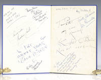
1939112422London: Macdonald and Co 1939. First edition of this overview of Hollywood. Quarto original cloth illustrated. Signed on the front pastedown and endpapers by <span class="match">Walt</span> <span class="match">Disney</span> and 13 other Hollywood actors and actresses including Chico Marx "To Pat Sincerely Chico Marx"; Pat O'Brien; "To Pat my own namesake Love Pat O'Brien Nov 21 1947; Deborah Kerr "I see a dark Stranger" on page 76 "with best wishes Deborah Kerr"; Merle Oberon "To Pat all the best Merle Oberon"; Joe E. Brown "To Pat Joe Brown." Brown was one of the most popular American comedians in the 1930s and 1940s with films like A Midsummer Night's Dream Earthworm Tractors Alibi Ike and Some Like It Hot. Jack Train "Best wishes Pat Jack Train Don't' mind if I do"; Ray Milland "Merry Xmas Pat Ray Milland." Milland is best remembered for his Academy Award-winning portrayal of an alcoholic writer in The Lost Weekend<i> </i>leading man opposite John Wayne's corrupt character in Reap the Wild Wind 1942 the murder-plotting husband in Alfred Hitchcock's Dial M for Murder 1954 and Oliver Barrett III in Love Story. <sup id="cite_ref-mgrmdmg_3-0" class="reference"></sup>Two of the signatures are pasted onto the end papers while the rest are signed directly onto the end papers with one on page 76. Near fine in a very good dust jacket. An exceptional collection of signatures in this film review book. Macdonald and Co hardcover books
14710S. BRUNS BARNES 1967. FIRST EDITION VERY GOOD. F. S. BRUNS, BARNES, 1967 unknown books
14711S. BRUNS BARNES 1969. FIRST EDITION VERY GOOD. F. S. BRUNS, BARNES, 1969 unknown books
19697870baSSouth Brunswick NJ: A. S. Barnes & Company 1969. Book. Near fine condition. Hardcover. First Edition. Oblong octavo 8vo. 228 pages including an index. Hardcover binding measures 20.2 x 22.5cm with minimal shelfwear. Unclipped dustjacket with minor shelfwear and minor tears; protected in mylar. Profusely illustrated with black & white photos. Movies; periodical. The text is clean and unmarked. First edition. A. S. Barnes & Company Hardcover books
1939114789London: Macdonald and Co 1939. First edition of this overview of Hollywood. Quarto original cloth illustrated. In very good condition. Macdonald and Co hardcover books
191824367Chicago: Union League Club of Chicago. 1918. First Edition; First Printing. Softcover. Wraps a very good copy with a little soiling and darkening. The author outlines why Germany must be stopped.; 8vo 8" - 9" tall; 28 pp . Union League Club of Chicago paperback books
1610022406London: John Spede Speed John Sudbury Georg George Humble 1610. First Edition . Single Folded Sheet. Near Fine/No Jacket. Image 20 1/2' x 15". 1610 date in both the title block and the printing information block. Original two page map from Speed's atlas in a very strong impression. Very attractive later color coastal water outlines blue with brown along land coastlines inset maps of Bangor and Caernarvon in light blue and orange borders in red shields in red all details nicely colored. Near fine print and coloring strong no tears or repairs very slight dust/soiling in small area in margins adjacent to center fold. Nicely framed with double glaze displaying the atlas pages 123 and 124 on the reverse. <br/> <br/> John Spede (Speed), John Sudbury, Georg (George) Humble unknown
1975RO20000214DESSAIN ET TOLRA. 1975. In-8. Cartonnage d'éditeurs. Etat d'usage, Couv. défraîchie, Dos satisfaisant, Intérieur frais. 117 pp., nombreuses figures dans le texte. Couverture de bibliothèque.. . . . Classification Dewey : 694-Menuiserie
1981RO70105714HACHETTE Bibliothèque Verte. 1981. In-12. Relié. Bon état, Couv. convenable, Dos satisfaisant, Rousseurs. 186 pages. Illustrations noir et blanc et couleur de Edouard Guenégaud. Tampons d'école.. . . . Classification Dewey : 843.0692-Livres d'enfants
1793Hachette 1981, collection bibliothèque verte cartonnée, illustrations de Edouard Guénégaud; très bon état
1948RO60112905MacDonald & Co. 1948. In-8. Relié. Etat d'usage, Couv. légèrement passée, Dos frotté, Intérieur acceptable. 160 pages. Illustré de nombreuses photos en noir et blanc et en couleur, dans et hors texte. Texte sur 2 colonnes. Couverture se détachant légèrement. Annotations en page de garde (ex-dono). Jaquette manquante.. . . . Classification Dewey : 420-Langue anglaise. Anglo-saxon