Robert SpeedBiblio.com
6 résultats
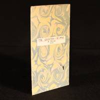
1710931F22London: printed and sold by the booksellers of London and Westminster 1710 . Paperback. Very Good Indeed. 7" by 4.5". None. A scarce early eighteenth century piracy of Robert Speed's scarce poem about a fight in a debtors prison. First published in 1621 and scarce in all contemporary editions.This is a pirate edition produced by Henry Hills but without his name appearing to the title page.A mock-heroic satire from Robert Speed detailing a brawl in the Wood Street Compter or debtors' prison between two tradesmen. ESTC T58812. With the label of J. O. Edwards to the front pastedown.An attractive example of this work. Rebound in paper wraps with a title label to the front wrap. Small ink mark towards tail of front wrap. Endpapers renewed. Name label to front pastedown. Internally firmly bound. Pages age toned due to the paper type but generally clean. Very Good Indeed printed, and sold by the booksellers of London and Westminster paperback
171312789London: Henry Overton Bassett & Chiswell 1713. Copper-engraved map with full modern colour very large marings in very good condition except for a stain at the bottom edge well away from the image. A highly decorative map of Denbighshire by one of the greatest English cartographers<br/> <br/>Denbighshire in Wales clearly a mountainous region was surveyed by Christopher Saxton which was Speed's source for this map. William Smith Pursuivant at the College of Arms was the apparent source for the coats of arms: one of which is that of Robert Dudley Earl of Leicester Queen Elizabeth's favorite. In the town plan of Denbigh in the upper right corner is a circular inset displaying what appears to be a castle. It is actually an unfinished and indeed never finished church that Leicester had tried to have built in Denbigh. Apparently his unpopularity was part of the reason the church was never completed. The map is decorated with a sea monster a classical god on horseback and a ship. Henry Overton's edition of this map includes the few roads that snaked their way through the county.<br/> <br/>cf. Hawkyard and Nicolson The Counties of Britain A Tudor Atlas by John Speed p. 73-76; Skelton The County Atlases of the British Isles 1579-1850 Map Collector's Circle part 1 #7 Speed and part 4 #92 & 121. Henry Overton, Bassett & Chiswell unknown books
171312789London: Henry Overton Bassett & Chiswell 1713. Copper-engraved map with full modern colour very large marings in very good condition except for a stain at the bottom edge well away from the image. A highly decorative map of Denbighshire by one of the greatest English cartographers<br/> <br/> Denbighshire in Wales clearly a mountainous region was surveyed by Christopher Saxton which was Speed's source for this map. William Smith Pursuivant at the College of Arms was the apparent source for the coats of arms: one of which is that of Robert Dudley Earl of Leicester Queen Elizabeth's favorite. In the town plan of Denbigh in the upper right corner is a circular inset displaying what appears to be a castle. It is actually an unfinished and indeed never finished church that Leicester had tried to have built in Denbigh. Apparently his unpopularity was part of the reason the church was never completed. The map is decorated with a sea monster a classical god on horseback and a ship. Henry Overton's edition of this map includes the few roads that snaked their way through the county.<br/> <br/> cf. Hawkyard and Nicolson The Counties of Britain A Tudor Atlas by John Speed p. 73-76; Skelton The County Atlases of the British Isles 1579-1850 Map Collector's Circle part 1 #7 Speed and part 4 #92 & 121. Henry Overton, Bassett & Chiswell unknown
1760e8831London: W. Owen at Homer's Head Temple-Bar. G : in Good condition. Boards scuffed with edge wear. Spine cracked with wear at base. Text block firm. 1760. Fourth Edition Revised and Corrected. Quarter leather marbled board cover. 180mm x 100mm 7" x 4". xii vi 328pp 118pp. Two engraved plates. ' To which is added a translation of Dr. Speed's commentary on sea water. As also an account of the nature properties and uses of all the remarkable mineral waters in Great Britain.' Bound with an extract pages 165-283 from Francis Fuller ' Medicina Gymnastica: or A treatise concerning the power of exercise with respect to the animal oeconomy and the great necessity of it in the cure of several distempers'. . W. Owen, at Homer's Head, Temple-Bar hardcover
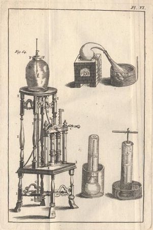
17422698Paris, David Fils, 1742 ; in-8 ; plein veau marbré, dos à nerfs décoré, pièce de titre grenat, tranches rouges (reliure de l'époque) ; XVI pp., 458 pp., (5) ff. de table, (2) pp. (explication des parties de la machine pneumatique), (1) f. de privilège ; vignette de titre gravée par Duflos et 6 planches dépliantes.
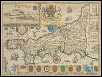
171021976<p>London: And Now Sold by Henry Overton at the White Horse without Newgate London 1710-1743. 385 by 510mm. 15.25 by 20 inches. Speed's map of Cornwall Double-page engraved map with hand colour. A map of Cornwall from one of the Overton editions of the first large-scale atlas of the British Isles Speed's 'Theatre'. In the top left-hand corner is a prospect of 'Launceston or Ancient Dunhevet'. Along the right-hand side of the map four antiquities are illustrated including the Hurlers Stones which according to legend are men petrified for playing hurling on a Sunday. The sea around the peninsula is filled with sea-monsters and ships. John Speed 1552-1629 was the outstanding cartographer of his age. By trade a merchant tailor but by proclivity a historian it was the patronage of Sir Fulke Greville poet and statesman that allowed him to pursue this interest in earnest. His 'Theatre of Great Britain' from which the present work is drawn was first published in 1611 or 1612 and is 'the earliest English attempt at atlas-production on a grand scale' Skelton. Drawing heavily on the work of Saxton and Norden little of Speed's cartography is original he acknowledges 'I have put my sickle into other mens corne' instead it is his blend of cartography and history incorporating town-plans vignettes and genealogy that makes Speed an innovator. This map is from one of the editions of the 'Prospect' published by Henry Overton between ca. 1710 and 1743. Unlike in earlier editions the verso of the maps tend to be blank.</p> And Now Sold by Henry Overton at the White Horse without Newgate London,