SPEED, JohnBiblio.com
1 204 résultats
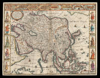
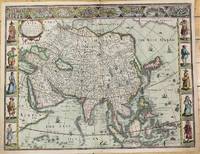
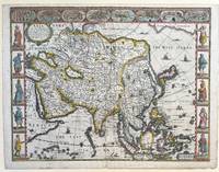
1627337000London: George Humble 1627. unbound. Map. Engraving with hand coloring. Image measures 15 3/8" x 20".<br/> <br/> This fascinating 1626 map of Asia by John Speed is the first British map of Asia. The map presents the entire continent from the Mediterranean east to include Japan and the East Indies. The map presents many speculations and common conventions found at a time when parts of Asia were largely unexplored by Europeans.<br> <br> Korea is presented as an elongated peninsula while the Kamchatka Peninsula is entirely absent. The map shows Japan and a fairly detailed depiction of the East Indies. Further west the Caspian Sea is presented along its East-West axis as per the practice at the time. The Great Wall of China is depicted in a grand style. Throughout several kingdoms important cities rivers lakes islands mountains and other topographical features are noted.<br> <br> One of the most interesting cartographic feature on this map is the appearance of Lake Ciamay or Lake Chiamay near northeast India. This mythical lake appeared on maps from the 16th to late 18th century and was believed to be the source of the great rivers of Southeast Asia.<br> <br> Illustrations of ships and sea monsters are included. The map is surrounded on the left and right with illustrations of the costumes and people from various parts of the continent. Along the top border eight city views are included detailing Candy Goa Damascus Jerusalem Ormus Bantam Aden and Macao.<br> <br> Engraved by Abraham Goos 1590 - 1643 a master engraver was the son of Pieter Goos and Margareta van den Keere which were both from map families. Appears in Speed's important "Prospect of the Most Famous Parts of the World". The map is in good condition. Archival repair to closed tear at lower margin near centerfold. Minor staining at edges not affecting the image. English text on verso.<br> <br> John Speed 1552-1629 is widely considered to be the most famous English cartographer of the 17th century. His atlas "The Theatre of the Empire of Great Britaine" contained the first set of individual county maps of England and Wales as well as significant town plans that are in many cases the first visual records of their subjects. This important map of Asia is a wonderful example of his work.<br/> <br/> George Humble unknown
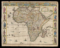
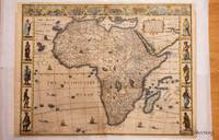
162621913<p>London: published at the charges of G. Humble 1626 but 1627-1632. 390 by 500mm. 15.25 by 19.75 inches. The first English map of Africa Double-page engraved map with hand-colour. The first English map of Africa from the first atlas compiled and published by an Englishman Speed's 'Prospect'. The map was engraved by Abraham Goos for Speed's 'Prospect of the Most Famous Parts of the World'. Along the top border are eight inset views of cities mainly in North Africa for example Alexandria Tangier and Tunis; along the side margins are inset engravings of people from different regions. The map is dense with place names rivers mountains and lakes many fictitious. While ships and sea-monsters populate the sea inland are depicted animals including zebras elephants lions and monkeys. The source of the Nile is given to the Lakes Zaire and Zaflan as according to Ptolemy. Accompanying text in English 'The Description of Africa' is printed on the reverse. John Speed 1552-1629 was the outstanding cartographer of his age. By trade a merchant tailor but by proclivity a historian it was the patronage of Sir Fulke Greville poet and statesman that allowed him to pursue this interest in earnest. His 'Theatre of Great Britain' first published in 1611 or 1612 was the first large-scale printed atlas of the British Isles. The 'Prospect of the Most Famous Parts of the World' from which the present work is drawn appeared in 1627 bound with the 'Theatre' and is the first world atlas compiled by an Englishman to be published in England. Engraved in Amsterdam many of the maps are anglicized versions of works by Dutch makers in distinctive carte-à-figure style featuring borders with figures in local costume and city views. Norwich 30; Shirley Atlases T.SPE-2a.</p> published at the charges of G. Humble,
162621912<p>London: Are to be sold in pops-head alley against the Exchange by G. Humble 1626 but 1627-1632. 400 by 510mm. 15.75 by 20 inches. The first English printed map of Asia Double-page engraved map with hand-colour. The first English printed map of the continent of Asia from the first atlas compiled and published by an Englishman Speed's 'Prospect'. The map is heavily influenced by Hondius' 1623 map and inherits the gaps in his geographical understanding of Asia: Korea is presented as a peninsula and an anonymous stretch of water separates Asia from America identified only as a blending of 'The Tartarian Sea' and 'The West Ocean'. In India one finds the mythical 'Lake Ciamay' a common feature of European maps of Asia from the 16th to the 18th c. the imagined source of the major rivers of south-east Asia. The map is not without topographical accuracy however. In China the Great Wall of China is depicted described as 'a bulwarke against the suddaine infall of ye Tartars on this side'. Vignettes in the border at the top of the map depict bird's-eye views of important towns among them 'Goa' and 'Aden'. Illustrated in the borders along the sides of the map are costumed figures. Accompanying text in English 'The Description of Asia' is printed on the reverse. John Speed 1552-1629 was the outstanding cartographer of his age. By trade a merchant tailor but by proclivity a historian it was the patronage of Sir Fulke Greville poet and statesman that allowed him to pursue this interest in earnest. His 'Theatre of Great Britain' first published in 1611 or 1612 was the first large-scale printed atlas of the British Isles. The 'Prospect of the Most Famous Parts of the World' from which the present work is drawn appeared in 1627 bound with the 'Theatre' and is the first world atlas compiled by an Englishman to be published in England. Engraved in Amsterdam many of the maps are anglicized versions of works by Dutch makers in distinctive carte-à-figure style featuring borders with figures in local costume and city views. Chubb XXV; 'Mapping the Continent of Asia' 30; Shirley Atlases T.SPE-2a; Suárez 200.</p> Are to be sold in pops-head alley against the Exchange by G. Humble,
163230290London: John Dawson for George Humble 1632. Folio pp. 22 1237 i.e. 1281 - page numbers 1043-1086 assigned to recto only 85; includes the preliminary blank leaf; engraved frontispiece portrait of Speed by S. Savery numerous woodcut illustrations and genealogical tables throughout; numerous woodcut initials and ornaments; contemporary full calf perfunctorily rebacked in brown calf maroon morocco label on spine; several clean tears entering text no loss leaf 5a with small piece missing from fore-edge causing minor loss to a few words and numbers light occasional dampstains; a good sound complete copy. A continuation of his Theatre of Great Britaine whose contents are described in this volume as The Chorographicall Part accounting for the first 4 books. This volume The Historicall Part therefore begins with "the fifth booke" but is complete in itself. STC 23049; Graesse V 462-63; Lowndes 2471-72. <br/><br/> John Dawson, for George Humble unknown books
16643551London: Rowland Reynolds. Very Good. 1664. First Edition. Rebacked with new endpapers; early twentieth century blind & gilt embossed spine over contemporary full ruled sheep. Fore edge corners renewed. Four full page engravings: incl. frontis of James Howell standing in a wood; his coat of arms to the left which seems to be borrowed form his 'Dendrologie' Paris1641; Charles II of Britain Louis XIV of France & Philip IV of Spain with chapters corresponding to each monarch.; Folio; Additional images and further information provided upon request. ; All shipments through USPS insured Priority Mail. . Rowland Reynolds
1963151483Tooele County UT: N.p. 1963. Archive of 163 vernacular photographs including 145 in color and 18 in black-and-white capturing the 1960-1963 National Speed Trials commonly known as Speed Week at the Bonneville Salt Flats in Utah. Housed in 17 yellow envelopes with dates and names of racers written in holograph ink annotation to the rectos. <br/><br/>Offered with the archive is a brand new set of the two-volume Bonneville National Speed Trials references covering 1949-1958 and 1959-1968 respectively. The set is new and still in shrinkwrap.<br/><br/>In the early 1960s wealthy California car owners began to experiment with surplus jet engines to boost the horsepower of their cars creating distinctive bootlegged hotrods referred to as jet cars or jets designed specifically for the compacted salt surface of the flats. <br/><br/>The photographs in the archive document many early iterations of these unusual and profoundly dangerous vehicles with a particular focus on racers from southern California including Art Arfons' 8000-horsepower Cyclops which set a record for an open-cockpit vehicle 342 mph which still stands today and Mickey Thompson's Challenger I the first car to record a top speed of 400 mph. Also notable are several photographs of the streamliner entries of the Summers brothers in 1961 1962 and 1963 whose streamliner Goldenrod would go on to hold the land speed record from 1965 to 1991. <br/><br/>As a whole the photographs are bright and well-executed clearly shot with a racing insider's eye for detail. Photographs from the perspective of Speed Week attendees are scarce owing to the relatively remote locale and complete absence of accommodations for spectators making the images in the archive an uncommon intimate record of several pivotal years in the history of hotrod racing.<br/><br/>Photographs 5.75 x 3.5 inches envelopes 7.5 x 4. Some photographs with faint adhesive residue to the versos else envelopes and photographs generally Near Fine.<br/><br/>Full provenance available. N.p. unknown books
1626M10939London c.1626. Very Good. Notes: English text on verso.<br>First British map of Asia the map has 8 town plans in upper border and costumes of inhabitants of Asia in side borders. Size : 395x514 mm 15.55x20.24 Inches Coloring: Original Hand Coloring Category: Maps Asia Continent; unknown
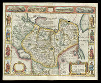
1626273459London: George Humble 1626. unbound. Map. Engraving with hand coloring. Image measures 15.25" x 19.75".<br/><br/> This beautiful carte a figures map of Tartary by John Speed presents the many geography speculations found at a time when parts of Asia were largely unexplored by Europeans. Extends from Armenia eastward to include part of North America and includes the Arctic Sea and Nova Zembla.<br><br>Korea is presented as an Island while the Kamchatka Peninsula is entirely absent. The Straits of Anian believed to be associated with the mythical Northwest Passage is identified. The Great Wall of China is depicted in a grand style south of which lies the Kingdom of China. Throughout several kingdoms important cities rivers lakes islands mountains and other topographical features are noted. These includes important cities which were part of the ancient Silk Route.<br><br>The Caspian Sea presented along its East-West Axis according to the practice of the time is identified by various names Sea of Sala otherwise Bachu called by the Russians Chualenske More in old time the Caspian and Hircan Sea. Further north Tazota Island from the Roman geographer Pliny the Elder appears in the Arctic Circle.<br><br>Beijing or Peking appears north of the Great Wall and is identified by the name Cambalu as used my Marco Polo. Interesting notations are also included throughout including one north of the Great Wall reading "In this Country is a hil out of which they dig earth called by Pliny terra Asbestus having fine veines like grasse which being spun and weaved yeeld cloth that wil nut burn in the fire".<br><br>The map is surrounded on the left and right with illustrations of the costumes and people from various parts of the region. Along the top border four views are included detailing the cities Astrakan Samarkand Cambalu and a view of the house of Nova Zembla.<br><br>Engraved by Dirck Grijp. Appears in Speed's important "Prospect of the Most Famous Parts of the World". The map is in good condition with some wear along the original centerfold. Overall foxing and some tape residue long the top margin from framing. Very good impression. English text verso.<br><br>John Speed 1552-1629 is widely considered to be the most famous English cartographer of the 17th century. His atlas "The Theatre of the Empire of Great Britaine" contained the first set of individual county maps of England and Wales as well as significant town plans that are in many cases the first visual records of their subjects. This important map of Asia is a wonderful example of his work.<br/><br/> George Humble unknown books
1632129648At London : Printed By Iohn Dauuson For George Humble And Are To Be Sold In Popes-Head Pallace At The Signe Of The White Horse 1632. Third Edition. Hardback. Finely and period sympathetically bound in modern aniline calf over marble boards. Raised bands with a dark morocco gilt-blocked label. An uncommonly good example - scans and additional bibliographic detail on request. ; 1237 pages; With sundry descents of the Saxons kings their marriages and armes. Signatures: par. 6 -par. 1 A8 B-2H6 2I4 2K-4S6 4T4 4V-4Z6 5A8 5B-5Y6 5Z4. Physical desc. : 20 1237 i. E. 1281 85 p. : ill. geneal. Tables. This third edition has been reissued enlarged and newly corrected. Subject: Great Britain - History - To 1485. Referenced by: STC 2nd ed. 23049. At London : Printed By Iohn Dauuson, For George Humble, And Are To Be Sold In Popes-Head Pallace, At The Signe Of The White Hors hardcover
167621929<p>London: and are to be sold by Tho: Bassett in Fleet Street & Richard Chiswell in St. Pauls Churchyard 1676. 395 by 510mm. 15.5 by 20 inches. Speed's map of 'Tartary' Double-page engraved map with hand-colour. A map of Tartary encompassing parts of modern-day Siberia and Central Asia from the 1676 edition of the first atlas compiled and published by an Englishman Speed's 'Prospect'. The decorative border that runs along the top of the map depicts views of major cities as well as the house built on 'Nova Zemla' Novaya Zemlya by the explorer Willem Barentsz and his crew stranded there in 1596 here presented fending off a polar bear. Along each side are illustrated figures in regional costume. Accompanying text in English 'The Description of the Kingdom of Tartary' is printed on the reverse. John Speed 1552-1629 was the outstanding cartographer of his age. By trade a merchant tailor but by proclivity a historian it was the patronage of Sir Fulke Greville poet and statesman that allowed him to pursue this interest in earnest. His 'Theatre of Great Britain' first published in 1611 or 1612 was the first large-scale printed atlas of the British Isles. The 'Prospect of the Most Famous Parts of the World' from which the present work is drawn appeared in 1627 bound with the 'Theatre' and is the first world atlas compiled by an Englishman to be published in England. Engraved in Amsterdam many of the maps are anglicized versions of works by Dutch makers in distinctive carte-à-figure style featuring borders with figures in local costume and city views. This map is from the 1676 edition of the 'Prospect' published by Thomas Bassett and Richard Chiswell. While not as rare as the earlier publications this edition is perhaps the most important given that it is the first to include the nine new maps: among them Virginia and Maryland Barbados and Russia. It is also the last time that the 'Prospect' was printed as an atlas. Shirley Atlases T.SPE-2f.</p> and are to be sold by Tho: Bassett in Fleet Street & Richard Chiswell in St. Pauls Churchyard,
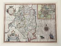
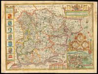
162764885London. 1627. A handsome early Sudbury and Humble edition of John Speed's map of Oxfordshire in colour. Towns and cities are highlighted in red decorative college arms and the supposed years of their foundation are found on either side of the map. A detailed inset map of the city of Oxford is in the upper right corner with a separate key with 28 listed city landmarks. The arms of the earl of Oxford to the right. Two academic university figures are seen standing with a pair of compass dividers either side of a striking globe representing the scale of miles. A strapwork border design and the royal coat of arms complete this map wonderfully well. Size: 395 x 535 mm. Copperplate engraving with later hand colouring. Fair condition. Some old repairs to lower central fold. Slight discolouration to the central fold. unknown
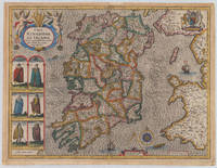
161038006London: John Sudbury and George Humble 1610-27. In very good to excellent condition. 38.5 x 51 cm 15.25 x 20 inches. Original antique copper engraving hand colored in outline and wash very likely old colored. Engraved by Jodocus Hondius. Published 1627 English text edition. Very decorative map of the County of the kingdom of Ireland. At the top left is the title cartouche on which two putti are sitting holding a harp. Below are six engraved costume prints depicting three couples: Gentleman / Gentlewoman of Ireland Civil Irish woman / Civil Irish Man Wild Irish man / Wild Irish woman. In the top right corner we the coat of arms with the inscription 'God and my right' in French language. In the Irish Sea next to the compass rose and mileage scale a sailing ship and a sea monsters are engraved. Below the imprint with the publisher John Sudbury and George Humble and the privileg dated 1610. An early edition of this rare map of Ireland with strong engraved waves in the sea. John Speed 1551 oder 1552 – 28. Juli 1629 war ein englischer Kartograf Chronologe und Historiker mit Wurzeln in Cheshire. Als Sohn eines Bürgers und Schneiders in London verließ er den Beruf seiner Familie um die Aufgabe anzunehmen die Geschichte Topografie und Karten der Königreiche Großbritanniens zusammenzustellen und zu überarbeiten um die Vereinigung ihrer Monarchien in der Person von König James I. und VI. darzustellen. Er erreichte dies mit bemerkenswertem Erfolg mit der Unterstützung und Hilfe der führenden Altertumsforscher seiner Generation. Er stützte sich auf die Shire-Karten von Christopher Saxton John Norden und anderen und verbesserte sie indem er als Erster die Hundertgrenzen in sie einfügte und er war der Landvermesser und Urheber vieler der darin enthaltenen Stadtpläne. Seine Arbeit trug dazu bei frühneuzeitliche Konzepte der britischen Nationalidentität zu definieren. Seine biblischen Genealogien wurden auch offiziell mit der Erstausgabe der King-James-Bibel in Verbindung gebracht. Er gehört zu den berühmtesten englischen Kartografen. Wikipedia.A minor marginal light staining in very good to excellent condition. 2nd English edition 1616 P. 255 John Sudbury and George Humble unknown
1626320851626. John Speed was a notable cartographer and historian of Britain. This decorative map is sought after by collectors because it is the first map of Africa prepared by a notable English cartographer. His Theatre of the Empire of Great Britaine was widely influential later editions of which included this map of Africa. The map first was published in A prospect of the most famous parts of the world which was a supplement to Speed's Theatre. Somewhat paradoxically this first English map of Africa was engraved by the famous Abraham Goos from Amsterdam - he was a relative of the Hondius family and therefore knew well the Dutch maps from which this map is derived. The map has a long publication history see Betz: published first by William Humble then his son George first state with date of 1626; then Roger Rea most of whose atlases were destroyed in the Great Fire of London 2nd state. Basset & Chiswell acquired Speed's plates after 1668 and published this 3rd state of the map together with maps of the other continents and the world map. Some time before 1690 Christopher Browne acquired the plates but a map of Africa from him is not known. The map is based maps of Jodocus Hondius whose Latin annotations are translated into English and Willem Blaeu his geography. The geography is typically early seventeenth century with its legendary Ptolemaic mountains rivers and lakes; typically the Nile arises from two lakes. The Europeans knew little about the interior of Africa and therefore there are numerous illustrations of terrestrial animals 'elephants for want of towns' according to Jonathan Swift; the oceans have ships and sea serpents. The English text on verso provides a fascinating view of the European concept concerning the wildlife customs and manners of the African people. There is a description of Anthropophagi cannibals who kill their own babies to avoid the trouble of raising them; but in order to preserve their race steal children from their neighbors. The side borders of this carte-a-figure map comprise sets of 5 decorative costumes of African peoples and the top border displays prospects of eight African Cities. Some of the border illustrations are copied from Willem Blaeu. At top is a panel of panoramas and plans illustrating Tanger Ceuta Alger Tunis Alexandria Cairo Alca Mozambique and the Canary Islands. This example of the map is in attractive colour and in very good condition. a few minor chips along the edges and an old repair on the bottom joint. Acid free mounting tape on the back. unknown
163230290London: John Dawson for George Humble 1632. Folio pp. 22 1237 i.e. 1281 - page numbers 1043-1086 assigned to recto only 85; includes the preliminary blank leaf; engraved frontispiece portrait of Speed by S. Savery numerous woodcut illustrations and genealogical tables throughout; numerous woodcut initials and ornaments; contemporary full calf perfunctorily rebacked in brown calf maroon morocco label on spine; several clean tears entering text no loss leaf 5a with small piece missing from fore-edge causing minor loss to a few words and numbers light occasional dampstains; a good sound complete copy. A continuation of his Theatre of Great Britaine whose contents are described in this volume as "The Chorographicall Part" accounting for the first 4 books. This volume "The Historicall Part" therefore begins with "the fifth booke" but is complete in itself. STC 23049; Graesse V 462-63; Lowndes 2471-72. John Dawson, for George Humble unknown
167621930<p>London: Sold by Tho: Basset in Fleet Street and Richard Chiswell in St. Pauls Church yard 1676. 405 by 515mm. 16 by 20.25 inches. Speed's map of Russia Double-page engraved map with hand-colour. A map of Russia one of the nine new maps added to the 1676 edition of Speed's 'Prospect' the first atlas compiled and published by an Englishman. Unusually this map is not in the carte-à-figure style that characterizes the 'Prospect'. Instead set in the top left-hand corner of the map is a detailed plan of Moscow with points of particular interest such as 'The Emperours Palace' and 'The Horse market' labelled. On the right-hand side is an elaborate cartouche containing views including 'Archangel' Arkhangelsk and 'A Hott House'. Accompanying text in English 'The Description of Russia' is printed on the reverse. John Speed 1552-1629 was the outstanding cartographer of his age. By trade a merchant tailor but by proclivity a historian it was the patronage of Sir Fulke Greville poet and statesman that allowed him to pursue this interest in earnest. His 'Theatre of Great Britain' first published in 1611 or 1612 was the first large-scale printed atlas of the British Isles. The 'Prospect of the Most Famous Parts of the World' from which the present work is drawn appeared in 1627 bound with the 'Theatre' and is the first world atlas compiled by an Englishman to be published in England. Engraved in Amsterdam many of the maps are anglicized versions of works by Dutch makers in distinctive carte-à-figure style featuring borders with figures in local costume and city views. This map is from the 1676 edition of the 'Prospect' published by Thomas Bassett and Richard Chiswell. While not as rare as the earlier publications this edition is perhaps the most important given that it is the first to include the nine new maps: among them Virginia and Maryland Barbados and the present example Russia. It is also the last time that the 'Prospect' was printed as an atlas. Shirley Atlases T.SPE-2f.</p> Sold by Tho: Basset in Fleet Street and Richard Chiswell in St. Pauls Church yard,
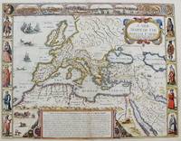
16769731London Thomas Bassett and Richard Chiswell 1676. Copper engraving 38.5 x 51.5 cm modern hand-colour closed tear in the sea beside the vignette of a naval engagement trivial spotting English text to verso. Speeds 'carte à figure' map of Italy with eight costume vignettes and six city views around the edges with the coats of arms of Corsica and Sardinia. John Speed 1552-1629 is unquestionably the most significant English map-maker of the seventeenth-century. The first edition of Speed's Theatre was published in 1612. It was the first atlas of the British Isles and the first attempt made by an Englishman to match the achievements of the great continental publishing houses - although much of the engraving of the copper plates was performed in Amsterdam by Jodocus Hondius. Our map of Italy appeared in Speeds Prospect of the Most Famous Parts of the World the first world atlas attributed to an Englishman first published in 1627; again many of the plates were engraved in Amsterdam mostly by Abraham Goos. Map unknown
41599LONDON JOHN DAWSON FOR GEORGE HUMBLE 1632. .THEIR ORIGINALS MANNERS HABITS WARRES COINES AND SEALS; WITH SUCCESSIONS LIVES ACTS AND ISSUES WITH THE ENGLISH MONARCH. THIRD EDITION. QUARTO ENGRAVED FRONTIS. 1232 PAGES WITH SUMMARY AND INDEX MANY WOODCUTS OF ARMS COINS AND PORTRAITS. SOMETIME REBOUND IN HALF LEATHER OVER MARBLED BOARDS NEW ENDPAPERS RAISED BANDS GILT TITLES. THE TITLE AND FRONTIS. HAVE BEEN REMOUNTED WITH SOME LOSS TO THE EDGES. WEAKNESS TO FRONT HINGE BUT A REMARKABLY GOOD HANDSOME COPY VERY CLEAN. LONDON, JOHN DAWSON FOR GEORGE HUMBLE, 1632 hardcover
1651M8291London: Tho: Basset; Richard Chiswell c. 1651. Very Good. Notes: StolenHighly decorative map of the Roman Empire. Includes illustrations of ships and sea monsters as well as various animals placed in their native lands. <br>Includes a decorative cartouche on the upper right side and a brief historical description of the history of the Roman Empire at the bottom of the map. Illustrations of Rome Geneva Jerusalem Venice Constantinople and Alexandria as well as various native people in costumes are placed around the map. Size : 391x509 mm 15.40x20.05 Inches Coloring: Original Hand Coloring Category: Maps Mediterranean Sea; Maps Asia Near East Turkey; Maps Europe Continent; Maps Africa Continent; Tho: Basset; Richard Chiswell unknown
1610M9855London c.1610. Very Good. Notes: John Speed's map of Leinster county; also with an <br>early plan of Dublin. Size : 382x511 mm 15.04x20.12 Inches Coloring: Original Hand Coloring Category: Maps Europe Ireland; unknown
167634894London: Thomas Basset & Richard Chiswell 1676. Copper-engraved map. Image area: 15 1/4 x 20 inches. Very good. Matted. The first state of Speed's early map of Virginia.<br/> <br/>As noted by Burden this was the first map to incorporate information from Augustine Hermann's Virginia and Maryland As it is Planted and Inhabited this present Year 1670 a landmark map of the region. While the general outlines of the map are taken from John Smith's map of 1612 much of the toponomy derives from Hermann as well as the representation of Delaware Bay which did not appear on Smith's map and a more accurate depiction of the northeastern shore of Chesapeake Bay. With very interesting text on the verso condensed from John Ogilby's America published in 1671.<br/> <br/>£Burden 456. Thomas Basset & Richard Chiswell unknown books
1676LTH20-A-5London: Thomas Bassett; Richard Chiswell 1676. Leather. Good. 17.5" by 13". None. A collection of leaves from the highly sought after geographical work; The Theatre of the Empire of Great Britain. Complete with the maps this is around £100000. Containing; the original title page in both red and black printing two dedication pages "To the Right Honourable Sir Joseph Sheldon" and "To the Most High and Most Potent Monarch James" three leaves of the preface three leaves of poetical works the "Contents of the Chorographical Part The First Book" through to the contents of "The King's Dominions Abroad" the title page to "The Second Book: Containing the Principality of Wales" page 97 and 98 of this work five leaves of road branch diagrams the title page to "The Third Book: Containing a General View of the Kingdom of Scotland" page 129 of this work the title page to "The Fourth Book: Containing the Kingdom of Ireland" page 135 of this work the title page to "A Prospect of the Most Famous Parts of the World" and the complete Index. Rebacked in a full contemporary calf binding with the original calf boards. Externally a trifle rubbed with wear to the extremities and minor cocking to the spine. Both hinges are tender. Internally binding is a little strained in places with some leaves working loose. Work is seriously incomplete with what is present listed above. Some scattered spotting and handling marks. Good Thomas Bassett; Richard Chiswell hardcover
16651785London: to be solde by Roger Rea ye Elder and younger at ye Golden Crosse in Cornhill against the Exchange 1665. 410 by 550mm. 16.25 by 21.75 inches. Double-page engraved map upper left and right margins skilfully repaired margins reinforced with japan paper. The map bears the imprint of Roger Rea the Elder and Younger. The Reas had purchased the rights to Speed's work from William Garrett in 1659 who had previously purchased them from the widow of William Humble in the same year. Skelton suggests that the father and son intended a new edition of the atlas for the Restoration of 1660. However the atlas would appear not to have been published until 1665. This is borne out by an advertisement in the Term Catalogue by the subsequent owners of the plates Thomas Bassett and Richard Chiswell in 1675: "Mr John Speed's. Geography of the Kingdoms of England Scotland and Ireland. together with his Prospect. all in one entire Volume hath been for seven Years past out of Print the greatest part of an Impression then newly Printed being destroyed by the late dreadful Fire 1666". This is borne out by the rarity of the Rea edition of the atlas. There is evidence that they planned an edition of 1666 as there are impressions of Sussex Buckingham and Derby with Rea's imprint which bear that date. Rea would later sell the plates to Bassett and Chiswell who would publish a new edition in 1676. to be solde by Roger Rea ye Elder and younger at ye Golden Crosse in Cornhill against the Exchange, unknown
16270020055London: George Humble. Sumptuously rebound in quarter calf by Period Binders of Bath with bright gilt titles to spine and five raised bands new cream endpapers with complementing brown buckram boards preserving Armorial Bookplate of Arthur Levin Josephs to fixed front endpaper. First page is professionally relaid title page followed by Dedication page Contents Page and Index of Chapters 12 155/924pp Second Index of Principal Events A to Z46pp. Numerous engarvings throughout as called for. Two pages in unpaginated second index at end have three inch horizontal tears with no loss. Otherwise all VG. . Very Good. Hardcover. Second Edition. 1627. George Humble hardcover
16651761London: to be solde by Roger Rea ye elder & younger at ye Golden Crosse in Cornhill agt. ye Exchang 1665. 410 by 550mm. 16.25 by 21.75 inches. Double-page engraved map fine contemporary outline hand colour upper left and right margins skilfully repaired margins reinforced with japan paper. The map bears the imprint of Roger Rea the Elder and Younger. The Reas had purchased the rights to Speed's work from William Garrett in 1659 who had previously purchased them from the widow of William Humble in the same year. Skelton suggests that the father and son intended a new edition of the atlas for the Restoration of 1660. However the atlas would appear not to have been published until 1665. This is borne out by an advertisement in the Term Catalogue by the subsequent owners of the plates Thomas Bassett and Richard Chiswell in 1675: "Mr John Speed's. Geography of the Kingdoms of England Scotland and Ireland. together with his Prospect. all in one entire Volume hath been for seven Years past out of Print the greatest part of an Impression then newly Printed being destroyed by the late dreadful Fire 1666". This is borne out by the rarity of the Rea edition of the atlas. There is evidence that they planned an edition of 1666 as there are impressions of Sussex Buckingham and Derby with Rea's imprint which bear that date. Rea would later sell the plates to Bassett and Chiswell who would publish a new edition in 1676. to be solde by Roger Rea ye elder & younger at ye Golden Crosse in Cornhill agt. ye Exchang, unknown
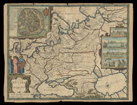
97473Are to be sold by Ric. Chiswell on St. Pauls Church yard and by The: Bassett in Fleetstreet. 1676. Lg.map engr.surface ca 55 cm x 42 cm. Frame 61.5cm x 50cm Nicely hand-coloured. An attractive and decorative map Featured "carte a figure" map adorned with side panels depicting costumed figures and further enhanced with a row of city views along the top. Prague is at the centre. The Danube River flows from west to east along the bottom of the map. An inset at right explains the symbols used. Very good. Framed in double glazed Mount. English text on verso. From: A Prospect of the Most Famous Parts of the World London Th. Bassett & R. Chiswell 1676. Are to be sold by Ric. Chiswell on St. Pauls Church yard and by The: Bassett in Fleetstreet. 1676 unknown