Speed Joseph J.ABAA

67 résultats
184156464Baltimore: Sherwood & Co 1841. First edition 8vo pamphlet 2 12 2; later paper wrappers; lightly foxed and folded very good. A pro-slavery tract arguing that slavery "is one of the primitive domestic relations ordained and established by the Creator. as one of the best means of promoting the happiness of the human family." Sabin 80086. Afro-Americana 9365 both incorrectly attributing the work to J. J. Sheed. See Sabin 89236 for correction. <br/><br/> Sherwood & Co unknown books
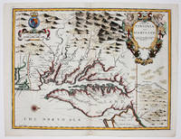
16769394London 1676. No Binding. Near Fine. 14 3/4 x 19 ¼ inches. Fine hand color; wear to bottom of centerfold else fine condition. A very attractive near-mint example. Speed's handsomely engraved work is one of the earliest English maps of the area and one of the first to demarcate the borders of colonial Virginia and Maryland. Just three years before the publication of Speed's map Augustine Herrman had conducted the first thorough surveys of Maryland at the behest of Lord Baltimore. Speed's was one of the first maps to adopt this groundbreaking cartography. However in general outline Speed still followed the prototype of Captain John Smith who conducted the first European survey of Chesapeake Bay. Speed's map "is the last major derivative of the Smith map and it is unique as an example of the transition from one basic prototype map to another. The delineation of the land area follows Smith while the toponymic prototype was the Herrman map of 1673." Verner in Tooley Mapping of America p.170 A particularly important feature derived from Herrman by Speed is the boundary line indicated by a double row of trees between Virginia and Maryland on the Eastern Shore. English text on the verso contains extensive descriptions of Virginia and Maryland. unknown books
167634894London: Thomas Basset & Richard Chiswell 1676. Copper-engraved map. Image area: 15 1/4 x 20 inches. Very good. Matted. The first state of Speed's early map of Virginia.<br/> <br/>As noted by Burden this was the first map to incorporate information from Augustine Hermann's Virginia and Maryland As it is Planted and Inhabited this present Year 1670 a landmark map of the region. While the general outlines of the map are taken from John Smith's map of 1612 much of the toponomy derives from Hermann as well as the representation of Delaware Bay which did not appear on Smith's map and a more accurate depiction of the northeastern shore of Chesapeake Bay. With very interesting text on the verso condensed from John Ogilby's America published in 1671.<br/> <br/>£Burden 456. Thomas Basset & Richard Chiswell unknown books
1626273459London: George Humble 1626. unbound. Map. Engraving with hand coloring. Image measures 15.25" x 19.75".<br/><br/> This beautiful carte a figures map of Tartary by John Speed presents the many geography speculations found at a time when parts of Asia were largely unexplored by Europeans. Extends from Armenia eastward to include part of North America and includes the Arctic Sea and Nova Zembla.<br><br>Korea is presented as an Island while the Kamchatka Peninsula is entirely absent. The Straits of Anian believed to be associated with the mythical Northwest Passage is identified. The Great Wall of China is depicted in a grand style south of which lies the Kingdom of China. Throughout several kingdoms important cities rivers lakes islands mountains and other topographical features are noted. These includes important cities which were part of the ancient Silk Route.<br><br>The Caspian Sea presented along its East-West Axis according to the practice of the time is identified by various names Sea of Sala otherwise Bachu called by the Russians Chualenske More in old time the Caspian and Hircan Sea. Further north Tazota Island from the Roman geographer Pliny the Elder appears in the Arctic Circle.<br><br>Beijing or Peking appears north of the Great Wall and is identified by the name Cambalu as used my Marco Polo. Interesting notations are also included throughout including one north of the Great Wall reading "In this Country is a hil out of which they dig earth called by Pliny terra Asbestus having fine veines like grasse which being spun and weaved yeeld cloth that wil nut burn in the fire".<br><br>The map is surrounded on the left and right with illustrations of the costumes and people from various parts of the region. Along the top border four views are included detailing the cities Astrakan Samarkand Cambalu and a view of the house of Nova Zembla.<br><br>Engraved by Dirck Grijp. Appears in Speed's important "Prospect of the Most Famous Parts of the World". The map is in good condition with some wear along the original centerfold. Overall foxing and some tape residue long the top margin from framing. Very good impression. English text verso.<br><br>John Speed 1552-1629 is widely considered to be the most famous English cartographer of the 17th century. His atlas "The Theatre of the Empire of Great Britaine" contained the first set of individual county maps of England and Wales as well as significant town plans that are in many cases the first visual records of their subjects. This important map of Asia is a wonderful example of his work.<br/><br/> George Humble unknown books
16279025633London: George Humble 1646 and 1627. Hardcover. Very good. Two works in one volume. Oblong octavo measuring 6 1/4 x 3 7/8 inches 16 x 9.75 cm.Rebound in full brown pebbled morocco with new tan endpapers. With custom made drop back folding clamshell slipcase in complementary tan cloth with leather spine labes stamped in gilt. First part with engraved title plus 19 engraved maps as called for. Second part with engraved title bound in upside down and remargined; Sixty - four maps called for in the index. Lacks map of England Scotland and Ireland1 and final map entitled MIDIA 64. Yorkshire map is missing section folded in from fore edge. 81 maps of 83 called for PLUS two engraved title pages. Some interior stains and foxing but still quite acceptable. A series of images is available on request. <br/><br/> George Humble hardcover books
166821680London: Printed for Roger Rea 1668. Third edition. This was first published in 1631. Maps removed they were printed with the text. lacking A2 &7 B5 C2 &8 D5 E2 &8 F5 G2 &7 H5 I2 &8 K4 L1 & 6 M3 &7 and N4 &8. 1 vols. Oblong 24mo 6 1/2 x 4 inches. Later green wrappers some browning of text lacking 21 leaves else a very good copy. Third edition. This was first published in 1631. Maps removed they were printed with the text. lacking A2 &7 B5 C2 &8 D5 E2 &8 F5 G2 &7 H5 I2 &8 K4 L1 & 6 M3 &7 and N4 &8. 1 vols. Oblong 24mo 6 1/2 x 4 inches. The section on America the D gathering is lacking the first and final leaves but the comments on Virginia are present "on the East it has Mare del Nort on the North Norumbega Florida on the South and Westward the bound are not yet set.The North parts are most inhabited by our men and it is therefore called New England." Florida is "'a Pleasant Region.discovered by our English under Sebastian Cubbot 1497 but left for the Spaniard to possess.and after him the French but neither in quiet. For they warred upon each other till they left neither of them men enough to hold it". Sabin 89228n Printed for Roger Rea unknown books
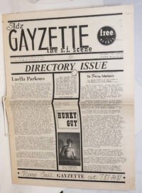
1971231921San Francisco: ADZ 1971. Newspaper. 8p. folded tabloid newspaper fewer personal ads and more local ads for gay services and sex toys toning newsprint. Special issue with centerfold maps to SF gay bars baths shops etc. ADZ unknown books
1953033292London: Penguin Books 1953. Forty plates from John Speed's pocket atlas of 1627. Introduced and described by E. G. R. Taylor. 31 1p. plus 40 colored illus. original stiff printed boards King Penguin books 61. Penguin Books unknown books
1610247261Sudbury & Humble 1610. Map. Engraving with hand coloring. Image measures 15 x 20".<br/><br/> This wonderfully decorated map depicts the island of Anglesey off the northwest coast of Wales. The island is centered on the map and labeled with towns rovers as well pictorial mountains and trees. A strapwork title cartouche features the coat of arms of England flanked by a lion and a unicorn. Below two elegant ships sail the beautifully patterned ocean surrounding an elaborate and colorful compass rose. In the lower left corner of the map showing part of Wales is an ornamental scale topped with strapwork cherubs a peacock and the country's coat of arms. A similar border frames the inset of Beaumaris in the upper right of the map which shows a plan of the port city labeled according to a key including its famous castle. The map appeared in Speed's atlas "The Theatre of the Empire of Great Britaine." It is in good condition with but margins are cropped. Expert repair to right corners. John Speed 1552-1629 is widely considered to be the most famous English cartographer of the 17th century. His atlas "The Theatre of the Empire of Great Britaine" contained the first set of individual county maps of England and Wales as well as significant town plans that are in many cases the first visual records of their subjects. This map of Anglesey is a beautiful example of his work.<br/><br/> Sudbury & Humble unknown books
1963151483Tooele County UT: N.p. 1963. Archive of 163 vernacular photographs including 145 in color and 18 in black-and-white capturing the 1960-1963 National Speed Trials commonly known as Speed Week at the Bonneville Salt Flats in Utah. Housed in 17 yellow envelopes with dates and names of racers written in holograph ink annotation to the rectos. <br/><br/>Offered with the archive is a brand new set of the two-volume Bonneville National Speed Trials references covering 1949-1958 and 1959-1968 respectively. The set is new and still in shrinkwrap.<br/><br/>In the early 1960s wealthy California car owners began to experiment with surplus jet engines to boost the horsepower of their cars creating distinctive bootlegged hotrods referred to as jet cars or jets designed specifically for the compacted salt surface of the flats. <br/><br/>The photographs in the archive document many early iterations of these unusual and profoundly dangerous vehicles with a particular focus on racers from southern California including Art Arfons' 8000-horsepower Cyclops which set a record for an open-cockpit vehicle 342 mph which still stands today and Mickey Thompson's Challenger I the first car to record a top speed of 400 mph. Also notable are several photographs of the streamliner entries of the Summers brothers in 1961 1962 and 1963 whose streamliner Goldenrod would go on to hold the land speed record from 1965 to 1991. <br/><br/>As a whole the photographs are bright and well-executed clearly shot with a racing insider's eye for detail. Photographs from the perspective of Speed Week attendees are scarce owing to the relatively remote locale and complete absence of accommodations for spectators making the images in the archive an uncommon intimate record of several pivotal years in the history of hotrod racing.<br/><br/>Photographs 5.75 x 3.5 inches envelopes 7.5 x 4. Some photographs with faint adhesive residue to the versos else envelopes and photographs generally Near Fine.<br/><br/>Full provenance available. N.p. unknown books
1627273306London: George Humble 1627. unbound. Map. Engraving with later hand coloring. Image measures 15.25" x 20".<br/><br/> This fascinating 1627 map of Asia by John Speed is the first British map of Asia. The map presents the entire continent from the Mediterranean east to include Japan and the East Indies. The map presents many speculations and common conventions found at a time when parts of Asia were largely unexplored by Europeans.<br><br>Korea is presented as an elongated peninsula while the Kamchatka Peninsula is entirely absent. The map shows Japan and a fairly detailed depiction of the East Indies. Further west the Caspian Sea is presented along its East-West axis as per the practice at the time. The Great Wall of China is depicted in a grand style. Throughout several kingdoms important cities rivers lakes islands mountains and other topographical features are noted.<br><br>One of the most interesting cartographic feature on this map is the appearance of Lake Ciamay or Lake Chiamay near northeast India. This mythical lake appeared on maps from the 16th to late 18th century and was believed to be the source of the great rivers of Southeast Asia.<br><br>Illustrations of ships and sea monsters are included. The map is surrounded on the left and right with illustrations of the costumes and people from various parts of the continent. Along the top border eight city views are included detailing Candy Goa Damascus Jerusalem Ormus Bantam Aden and Macao.<br><br>Engraved by Abraham Goos 1590 - 1643 a master engraver was the son of Pieter Goos and Margareta van den Keere which were both from map families. Appears in Speed's important "Prospect of the Most Famous Parts of the World". The map is in good condition with some wear and verso repair along the original centerfold. Overall foxing and narrow margins. English text verso.<br><br>John Speed 1552-1629 is widely considered to be the most famous English cartographer of the 17th century. His atlas "The Theatre of the Empire of Great Britaine" contained the first set of individual county maps of England and Wales as well as significant town plans that are in many cases the first visual records of their subjects. This important map of Asia is a wonderful example of his work.<br/><br/> George Humble unknown books
101075hardcover. 8vo cloth; inner hinge weak. St. Louis 1903.<br/><br/> unknown books
1918400527Chicago: The Reilly & Lee Co 1918. Hardcover. Very Good/Good. Twentieth edition. Pictorial red cloth stamped in black. Illustrated by William Donahey. Owner's Pinocchio bookplate on front pastedown pages lightly age-toned near fine in a good edgeworn dustwrapper spine faded with one inch chip on head. A sequel to Miss Minerva and William Green Hill. The Reilly & Lee Co hardcover books
1913258231913. Mosby Thomas Speed. Causes and Cures of Crimes. St. Louis: C.V. Mosby Company 1913. x 354 pp. Owner stamp to front free endpaper. Frontis. Illus. Hardcover. Original cloth very good. $65. Treats the technical aspects of criminality in a popular voice and calls for the abolishment of the penitentiary. Marke A Catalogue of the Law Collection at New York University 1953 475. unknown books
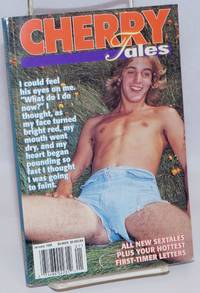
1998242443New Jersey: Second Wind Pub 1998. Magazine. 130p. illustrated with explicit erotic drawings very good digest size magazine in pictorial wraps. Erotic gay stories illustrated by drawings. Part of the Firsthand/Manscape/Guys series. Second Wind Pub unknown books
004895Phoenix: Cowboy Artists of America 1981. Pictorial Cover. Very Good. Limited. 9"x12". 66 pp. Owner's stamp front papers. 16th Exhibition. Phoenix: Cowboy Artists of America, 1981 unknown books
171312789London: Henry Overton Bassett & Chiswell 1713. Copper-engraved map with full modern colour very large marings in very good condition except for a stain at the bottom edge well away from the image. A highly decorative map of Denbighshire by one of the greatest English cartographers<br/> <br/>Denbighshire in Wales clearly a mountainous region was surveyed by Christopher Saxton which was Speed's source for this map. William Smith Pursuivant at the College of Arms was the apparent source for the coats of arms: one of which is that of Robert Dudley Earl of Leicester Queen Elizabeth's favorite. In the town plan of Denbigh in the upper right corner is a circular inset displaying what appears to be a castle. It is actually an unfinished and indeed never finished church that Leicester had tried to have built in Denbigh. Apparently his unpopularity was part of the reason the church was never completed. The map is decorated with a sea monster a classical god on horseback and a ship. Henry Overton's edition of this map includes the few roads that snaked their way through the county.<br/> <br/>cf. Hawkyard and Nicolson The Counties of Britain A Tudor Atlas by John Speed p. 73-76; Skelton The County Atlases of the British Isles 1579-1850 Map Collector's Circle part 1 #7 Speed and part 4 #92 & 121. Henry Overton, Bassett & Chiswell unknown books
1928015391Chicago: T S Denison. 1928. First Edition. Paperback. Wraps near fine with owner's name sheet music. . T S Denison paperback books
195539438NY: Popular Library 1955. Mass market paperback. Very good. Slight spine lean wraps lightly rubbed and edgeworn else very good. <br/><br/> Popular Library paperback books
14710S. BRUNS BARNES 1967. FIRST EDITION VERY GOOD. F. S. BRUNS, BARNES, 1967 unknown books
14711S. BRUNS BARNES 1969. FIRST EDITION VERY GOOD. F. S. BRUNS, BARNES, 1969 unknown books
19697870baSSouth Brunswick NJ: A. S. Barnes & Company 1969. Book. Near fine condition. Hardcover. First Edition. Oblong octavo 8vo. 228 pages including an index. Hardcover binding measures 20.2 x 22.5cm with minimal shelfwear. Unclipped dustjacket with minor shelfwear and minor tears; protected in mylar. Profusely illustrated with black & white photos. Movies; periodical. The text is clean and unmarked. First edition. A. S. Barnes & Company Hardcover books
1939114789London: Macdonald and Co 1939. First edition of this overview of Hollywood. Quarto original cloth illustrated. In very good condition. Macdonald and Co hardcover books
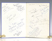
1939112422London: Macdonald and Co 1939. First edition of this overview of Hollywood. Quarto original cloth illustrated. Signed on the front pastedown and endpapers by <span class="match">Walt</span> <span class="match">Disney</span> and 13 other Hollywood actors and actresses including Chico Marx "To Pat Sincerely Chico Marx"; Pat O'Brien; "To Pat my own namesake Love Pat O'Brien Nov 21 1947; Deborah Kerr "I see a dark Stranger" on page 76 "with best wishes Deborah Kerr"; Merle Oberon "To Pat all the best Merle Oberon"; Joe E. Brown "To Pat Joe Brown." Brown was one of the most popular American comedians in the 1930s and 1940s with films like A Midsummer Night's Dream Earthworm Tractors Alibi Ike and Some Like It Hot. Jack Train "Best wishes Pat Jack Train Don't' mind if I do"; Ray Milland "Merry Xmas Pat Ray Milland." Milland is best remembered for his Academy Award-winning portrayal of an alcoholic writer in The Lost Weekend<i> </i>leading man opposite John Wayne's corrupt character in Reap the Wild Wind 1942 the murder-plotting husband in Alfred Hitchcock's Dial M for Murder 1954 and Oliver Barrett III in Love Story. <sup id="cite_ref-mgrmdmg_3-0" class="reference"></sup>Two of the signatures are pasted onto the end papers while the rest are signed directly onto the end papers with one on page 76. Near fine in a very good dust jacket. An exceptional collection of signatures in this film review book. Macdonald and Co hardcover books
1979015666Flagstaff AZ: Northland Press 1979. Book. Very good condition. Paperback. Signed by Authors. First Edition. Octavo 8vo. viii 109 pages of text. Paperback binding has minimal sunning to the extremities and minor shelfwear. Contains about 100 photographs of the artist the process and his works. Signed by the artist on the half-title page "U. Grant Speed" with no further inscription. The artist rarely signs his first name "Ulysses" or initial. The text is clean and unmarked. First edition. Northland Press Paperback books