SPEED, JOHN:Biblio.com
1 009 résultats
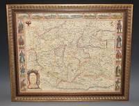
97473Are to be sold by Ric. Chiswell on St. Pauls Church yard and by The: Bassett in Fleetstreet. 1676. Lg.map engr.surface ca 55 cm x 42 cm. Frame 61.5cm x 50cm Nicely hand-coloured. An attractive and decorative map Featured "carte a figure" map adorned with side panels depicting costumed figures and further enhanced with a row of city views along the top. Prague is at the centre. The Danube River flows from west to east along the bottom of the map. An inset at right explains the symbols used. Very good. Framed in double glazed Mount. English text on verso. From: A Prospect of the Most Famous Parts of the World London Th. Bassett & R. Chiswell 1676. Are to be sold by Ric. Chiswell on St. Pauls Church yard and by The: Bassett in Fleetstreet. 1676 unknown
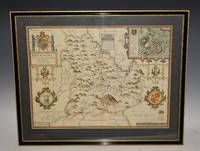
87950Bassett & Chiswell 1676. Lg. map engr.surface ca 51 cm x 37 cm. English text on verso. A nice example of this decorative County map by John Speed. Includes inset of Breknoke with the coat of arms for James Butler Earle of Breknoke and three other coasts of arms plus and early battle scene. FRAMED in double Glazed Hogarth Frame. Strong impression with the detail in the engraving clear and black. Overall in very good condition. Imprint on left- hand corner giving publishers: “Performed by John Speede. And are to be solde by Thomas Bassett in Fleetstreet and Richard Chiswell in St Pauls Churchyard”. The maps by J.Speed are "the best known and most popular of all English county maps" Tooley. Despite competition from maps of the English counties by Blaeu and Jansson Speed’ maps were “bestsellers”. A beautifully coloured map of the historic county of Brecknockshire with an inset map of the city of Brecon. Bassett & Chiswell, 1676 unknown
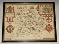
92126Sudbury & George Humbell 1610-1612. Engraved surface 20 x 15.50 inches. Frame Size 26.5 x 21.50 inches Attractive hand-colouring. A nice example of this decorative County map by John Speed. Includes inset of Breknoke with the coat of arms for James Butler Earle of Breknoke and three other coasts of arms plus and early battle scene. FRAMED in Glazed Hogarth Frame. Strong impression with the detail in the engraving clear and black. Frame has a few small chips. Overall in very good condition. Imprint on left- hand corner giving publishers: “Performed by John Speede. And are to be solde by Sudbury & George Humbell”. The maps by J.Speed are "the best known and most popular of all English county maps" Tooley. Despite competition from maps of the English counties by Blaeu and Jansson Speed’ maps were “bestsellers”. A beautifully coloured map of the historic county of Brecknockshire with an inset map of the city of Brecon. Sudbury & George Humbell 1610-1612 unknown
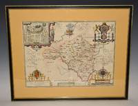
92117Sudbury & George Humbell 1610/11 1st Edition. Engraved surface 20 x 15.50 inches. With later light hand colouring. Frame Size 26.5 x 21.50 inches Attractive hand-colouring. Double glazed with English text on verso. An attractive and decorative map with inset town plan of Radnor scales of English Miles within large decorative cartouche and 3 elaborate coat of arms. Title cartouche and large compass rose. Strong impression with the detail in the engraving clear and black. Nice wide mustard margins. A few weak creases near centrefold. Overall in very good condition. A scarce edition. Imprint in the centre lower bottom giving publishers: “Described by Christopher Saxton Augmented and published by John Speede servant of his Majesty. And are to be solde in Popes head alley by John Sudbury & George Humbell The maps by J.Speed are "the best known and most popular of all English county maps" Tooley. Despite competition from maps of the English counties by Blaeu and Jansson Speed’ maps were “bestsellers”. Sudbury & George Humbell 1610/11 1st Edition unknown
1258162229.Gpaperback. Good. Access codes and supplements are not guaranteed with used items. May be an ex-library book. paperback
1962DC 167NY: Vantage Press 1962. SIGNED by Speed & Has DJ DJ has price & 1st stated Pages are browning -- John Orville Speed the Pennyrile Poet & from Madisonville KY -- EMAIL for Pictures. Signed by Author. First Edition. Hard Cover. Good/Good. Vantage Press Hardcover
1610247261Sudbury & Humble 1610. Map. Engraving with hand coloring. Image measures 15 x 20".<br/> <br/> This wonderfully decorated map depicts the island of Anglesey off the northwest coast of Wales. The island is centered on the map and labeled with towns rovers as well pictorial mountains and trees. A strapwork title cartouche features the coat of arms of England flanked by a lion and a unicorn. Below two elegant ships sail the beautifully patterned ocean surrounding an elaborate and colorful compass rose. In the lower left corner of the map showing part of Wales is an ornamental scale topped with strapwork cherubs a peacock and the country's coat of arms. A similar border frames the inset of Beaumaris in the upper right of the map which shows a plan of the port city labeled according to a key including its famous castle. The map appeared in Speed's atlas "The Theatre of the Empire of Great Britaine." It is in good condition with but margins are cropped. Expert repair to right corners. <br> <br> John Speed 1552-1629 is widely considered to be the most famous English cartographer of the 17th century. His atlas "The Theatre of the Empire of Great Britaine" contained the first set of individual county maps of England and Wales as well as significant town plans that are in many cases the first visual records of their subjects. This map of Anglesey is a beautiful example of his work.<br/> <br/> Sudbury & Humble unknown
20152-0007597436Harpercollins Publishers 2015. Paperback. New. fourth edition edition. 700 pages. 10.39x7.72x1.02 inches. Harpercollins Publishers paperback
20102-0415595401Routledge 2010. Paperback. New. 1st edition. 208 pages. 9.69x6.85x0.39 inches. Routledge paperback
A9780727766915Hardback. New. <p>This volume includes high-quality papers on best practice in planning design construction and management for large-scale railway infrastructure projects. It is divided into two sections: ground engineering geotechnics groundworks and earthworks and structural engineering bridges viaducts tunnels and underground structures.</p> hardcover
201113391London: Routledge 2011. 1st. Hardcover. Octavo; xiv 194 pages. New unread copy. Next day shipping. Celebrating our 15th year - all domestic orders ship with Delivery Confirmation Tracking Number - Images available upon request. Routledge hardcover
1404860444.Glibrary. Good. Access codes and supplements are not guaranteed with used items. May be an ex-library book. unknown
1404863931.Gpaperback. Good. Access codes and supplements are not guaranteed with used items. May be an ex-library book. paperback
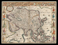
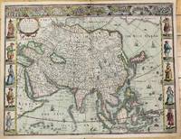
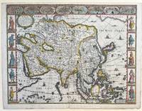
162621912<p>London: Are to be sold in pops-head alley against the Exchange by G. Humble 1626 but 1627-1632. 400 by 510mm. 15.75 by 20 inches. The first English printed map of Asia Double-page engraved map with hand-colour. The first English printed map of the continent of Asia from the first atlas compiled and published by an Englishman Speed's 'Prospect'. The map is heavily influenced by Hondius' 1623 map and inherits the gaps in his geographical understanding of Asia: Korea is presented as a peninsula and an anonymous stretch of water separates Asia from America identified only as a blending of 'The Tartarian Sea' and 'The West Ocean'. In India one finds the mythical 'Lake Ciamay' a common feature of European maps of Asia from the 16th to the 18th c. the imagined source of the major rivers of south-east Asia. The map is not without topographical accuracy however. In China the Great Wall of China is depicted described as 'a bulwarke against the suddaine infall of ye Tartars on this side'. Vignettes in the border at the top of the map depict bird's-eye views of important towns among them 'Goa' and 'Aden'. Illustrated in the borders along the sides of the map are costumed figures. Accompanying text in English 'The Description of Asia' is printed on the reverse. John Speed 1552-1629 was the outstanding cartographer of his age. By trade a merchant tailor but by proclivity a historian it was the patronage of Sir Fulke Greville poet and statesman that allowed him to pursue this interest in earnest. His 'Theatre of Great Britain' first published in 1611 or 1612 was the first large-scale printed atlas of the British Isles. The 'Prospect of the Most Famous Parts of the World' from which the present work is drawn appeared in 1627 bound with the 'Theatre' and is the first world atlas compiled by an Englishman to be published in England. Engraved in Amsterdam many of the maps are anglicized versions of works by Dutch makers in distinctive carte-à-figure style featuring borders with figures in local costume and city views. Chubb XXV; 'Mapping the Continent of Asia' 30; Shirley Atlases T.SPE-2a; Suárez 200.</p> Are to be sold in pops-head alley against the Exchange by G. Humble,
1626M10939London c.1626. Very Good. Notes: English text on verso.<br>First British map of Asia the map has 8 town plans in upper border and costumes of inhabitants of Asia in side borders. Size : 395x514 mm 15.55x20.24 Inches Coloring: Original Hand Coloring Category: Maps Asia Continent; unknown
1627337000London: George Humble 1627. unbound. Map. Engraving with hand coloring. Image measures 15 3/8" x 20".<br/> <br/> This fascinating 1626 map of Asia by John Speed is the first British map of Asia. The map presents the entire continent from the Mediterranean east to include Japan and the East Indies. The map presents many speculations and common conventions found at a time when parts of Asia were largely unexplored by Europeans.<br> <br> Korea is presented as an elongated peninsula while the Kamchatka Peninsula is entirely absent. The map shows Japan and a fairly detailed depiction of the East Indies. Further west the Caspian Sea is presented along its East-West axis as per the practice at the time. The Great Wall of China is depicted in a grand style. Throughout several kingdoms important cities rivers lakes islands mountains and other topographical features are noted.<br> <br> One of the most interesting cartographic feature on this map is the appearance of Lake Ciamay or Lake Chiamay near northeast India. This mythical lake appeared on maps from the 16th to late 18th century and was believed to be the source of the great rivers of Southeast Asia.<br> <br> Illustrations of ships and sea monsters are included. The map is surrounded on the left and right with illustrations of the costumes and people from various parts of the continent. Along the top border eight city views are included detailing Candy Goa Damascus Jerusalem Ormus Bantam Aden and Macao.<br> <br> Engraved by Abraham Goos 1590 - 1643 a master engraver was the son of Pieter Goos and Margareta van den Keere which were both from map families. Appears in Speed's important "Prospect of the Most Famous Parts of the World". The map is in good condition. Archival repair to closed tear at lower margin near centerfold. Minor staining at edges not affecting the image. English text on verso.<br> <br> John Speed 1552-1629 is widely considered to be the most famous English cartographer of the 17th century. His atlas "The Theatre of the Empire of Great Britaine" contained the first set of individual county maps of England and Wales as well as significant town plans that are in many cases the first visual records of their subjects. This important map of Asia is a wonderful example of his work.<br/> <br/> George Humble unknown
2019x-0367381818Auerbach Pub 2019. Paperback. New. 337 pages. 9.50x6.50x1.00 inches. Auerbach Pub paperback
2010x-1439809828CRC Pr I Llc 2010. Hardcover. New. 1st edition. 315 pages. 9.49x6.42x2.28 inches. CRC Pr I Llc hardcover
37581131-nnew. unknown
37581131like new. unknown
12266767-nnew. unknown
12266767like new. unknown
DADAX0367381818CRC Press 2019-09-19. 1. paperback. New. 6.14x0.77x9.21. Buy with confidence. Excellent Customer Service & Return policy. CRC Press paperback
2011SONG1439809828CRC Press 2011-12-20. 1. hardcover. Used: Good. 6.10x0.90x9.10. Buy with confidence. Excellent Customer Service & Return policy. CRC Press hardcover
1439809828.Ghardcover. Good. Access codes and supplements are not guaranteed with used items. May be an ex-library book. hardcover