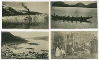
29 résultats
1802LD1833Weimar: Bureau de l'Industrie 1802-1804. Hardcover. Very Good. Atlas volumes; four bound together in one with a total of 73 plates. Vol. I: 12 plates one folding. Vol. II: 23 plates on 19 sheets. Vol. III: 24 plates 1-12 13a 13b 14-23. Vol. IV: 14 plates 1-7 8a 8b 9-13. A few maps lightly soiled and wrinkled along the edges but overall contents are nice and clean in worn scuffed binding. <br/><br/> Bureau de l'Industrie hardcover books
1900WRCAM54627Seattle; Skagway 1900. Twelve photographs each approximately 4 1/4 x 7 1/2 inches. Overall very good. A collection of photographs taken by Seattle photographer Frank La Roche. La Roche 1853- 1934 a Philadelphia native transplanted to the Northwest established a photography studio in Seattle in 1889. He undertook many trips to Alaska documenting the Klondike Gold Rush at length from 1897 to 1899. This group contains images of Juneau Sitka Fort Wrangell here spelled Wrangle and Taku Glacier. Two images are of Chilkat Tlingit Indians and one photo of the Seymour Rapids in British Columbia is also included. Each is numbered and captioned in manuscript or in print within the negative. Exemplary images from this noted landscape photographer of Alaska and the West. unknown books
1802262991Baltimore: Printed for Thomas Andrews & Butler. W. Pechin & S. Sower 1802. First American edition of the author's first published work. iv 7-172; 155 pp. 1 vols. 12mo. Bound to style in quarter brown calf and marbled boards preserving contemporary red morocco spine label. Foxing throughout very good. First American edition of the author's first published work. iv 7-172; 155 pp. 1 vols. 12mo. Author's First Book. Garside Raven & Schowerling: 1789:64 mentioning this edition and another in NY in 1802 ; Loeber and Loeber pp. 1134 Location: NUC InND Loeber coll; Block p. 200; Summers p. 163 first edition; Printed for Thomas, Andrews & Butler. W. Pechin & S. Sower unknown books
1832265137London: De La Rue Cornish & Rock 1832. 22 original drawings numerous plates some hand-colored pasted-in on variously colored leaves some with embossed frames by De La Rue & Co London manuscript verses throughout. 57 ll. Square 8vo. Contemporary dark purple morocco covers embossed in blind with large die of a rococo frame design surrounding a central diamond gilt-ruled border spine embossed in blind by a die with a cathedral design titled in gilt and signed by the binder "De La Rue Cornish & Rock" on the spine a.e.g. pink moire pastedowns. Very slight rubbing to binding edges light dampstaining to a few leaves endpapers evidently removed. 22 original drawings numerous plates some hand-colored pasted-in on variously colored leaves some with embossed frames by De La Rue & Co London manuscript verses throughout. 57 ll. Square 8vo. De La Rue Cornish & Rock Embossed Album. A commonplace book of particular interest for its embossed binding manufactured by De La Rue Cornish and Rock. From 1829 through 1832 Thomas de la Rue 1793-1866 partnered with Samuel Cornish and William Rock to manufacture cards embossed papers and playing cards. "De La Rue produced a number of fine albums annuals etc stamped on the back and sides with very finely executed blind imprints ." Ramsden. The De La Rue company still in operation is now one of the world's largest printers of commercial notes and paper. For binding cf. Maggs 1212 II no 241; Ramsden London Bookbinders p. 59 De La Rue, Cornish & Rock] unknown books
18881549Casa Blanca 1888. Very good. Manuscript map 18 x 23.5 inches. Drawn in black red and blue. Previously folded. Minor soiling and wear. An attractive manuscript map depicting the topography surrounding the small Sinaloan town of Santa Anita southeast of Culiacán near El Comedero. The map is somewhat oddly oriented with due north pointing toward the lower right corner of the sheet. It shows Santa Anita at its center with mountains to its east and dry plains to the west heading toward the Pacific Ocean. Two trails labeled "Camino Nacional de Culiacan" and "Camino del Veinticuatro" connect Santa Anita to the even smaller towns of Llano and Veinticuatro at the map borders. A small section of the Rio San Lorenzo is detailed at the eastern edge of the map area for context. The map was surveyed and drawn by Ignacio L. Rocha a graduate in 1883 of the reformed Colegio Rosales first founded in 1874. Three other maps by Rocha are located in the Mexican Agricultural Archives. A neat and appealing example. unknown books
18589321Chicago: Chas. Scott & Co 1858. Original printed wrappers 14pp. Spotted lightly worn old institutional and duplicate stamps one of which reads: "Presented by Judge and Mrs. Isaac R. Hitt Washington D.C." Isaac R. Hitt is listed on page 3 as a stockholder. Good. <br/><br/> A very scarce ante-fire imprint. "This company was chartered in January 1856 capitalized at $300000. It owned some 475 acres of coal lands in La Salle County on the Illinois Central Railroad and along the Illinois River. Chicago men who held stock in the company: James V.Z. Blaney B.S. Morris L.P. Hillard J.M. Wilson W.W. Mitchell and Charles M. Dupuy" Byrd. This Statement analyzes "the importance of cheap fuel to the City of Chicago" and the ability of the Company to provide it. <br/>FIRST EDITION. Ante-Fire Imprints 338 2. Byrd 2962 1. 336 NUC 0412784 2. OCLC 62978823 2- Chicago Hist. Mus. Newberry 62190408 2- U IL Lehigh as of September 2019. Chas. Scott & Co unknown books
18851099Chicago: Geo. F. Cram 1885. Good plus. Large folding pamphlet approximately 20 x 41.5 inches. A few small chips and short closed tears at edges; several short separations and very minor losses along folds. Contemporary agent's ink stamp on cover panel. Tape repair across portion of horizontal fold; one panel with patches of light staining. A scarce colorful promotional for the Rock Island Route as well as its national and international connections with a fascinating stamp of an Australian sales agent. One side of the sheet prints an extensive promotional text and timetables for the various routes and services of the Chicago Rock Island & Pacific Railway. The main side of the sheet prints a map of the United States with state borders shaded in four colors highlighting the principal routes of the Rock Island from Chicago to Minnesota Iowa and Kansas and its connections to points on both the East and West Coasts. An inset map at lower right promotes the Rock Island as part of a transcontinental route between the United Kingdom Ireland and Australia. Most interestingly this copy is stamped on the cover panel with the information of a George. H. Hibbard "Australian Passenger Agent America's Cons'd Trans-continental Railways 6 Bridge Street Sydney N.S.W." Hibbard was evidently the agent in charge of distributing information about the trans-America route in Sydney one of its end points. Several issues of this map were published during the 1880s all scarce. We locate copies of the present 1885 issue at Stanford SMU and the Library of Congress. Geo. F. Cram unknown books
1858406267New York: Benjamin F. Corlies 1858. A very good to near-fine copy with one closed tear and some light discoloration to the wrappers. 8vo. 10 pages. Original glazed-paper printed wrappers. Nine articles outline the structure of the company which had formed in 1847 as the Rock Island and LaSalle Rail Road Company and reincorporated under its new name in 1851. OCLC 4997635. Eberstadt catalogue 131 item 354. <br/><br/> Benjamin F. Corlies unknown books
185830039New York: Benjamin Corlies 1858. Original printed glossy wrappers light fading to lettering. Stitched. 10 2 blanks pp. Near Fine.<br/><br/> Founded in 1847 as the Rock Island and LaSalle Rail Road Company the Chicago and Rock Island reincorporated in 1851 and adopted these bylaws in 1858. In 1880 the Company was reorganized as the Chicago Rock Island and Pacific Railway. <br/>131 Eberstadt 354. Benjamin Corlies unknown books
18607334Chicago: Cameron Amberg & Co. Printers; and Shober & Carqueville Lithographers 1860. Trade card 13 x 7.5 cm. printed both sides the verso in chromolithography depicting the interior of a dining car with tables set in anticipation of the passengers' meals. Text on the recto reads "These Dining and Restaurant Cars run on the Chicago Rock Island & Pacific Railroad between Chicago and Omaha are in all respects the most luxurious traveling conveniences on the American continent. A bottle of fine French wine is served for an additional fifteen cents with an Extra Fine Meal for which only seventy-five cents is charged. Passengers will bear in mind that these are not the commonly-called Hotel Cars with their attendant high prices and bed-room odors. Our Dining Cars are used for no other purpose. All meals on Overland Trains are served in them. A. Smith Sup't Dining Car Line." The company became the Chicago Rock Island & Pacific Railroad in 1866 the company changed names frequently. In the mid-1870s the company established its Chicago-Omaha route. As such this card likely dates between the mid-1860s and mid-1870s. The railroad became known for introducing the first "elegant" dining cars to passenger trains and the lithograph on this trade card by Shober & Carqueville Lithographers of Chicago exudes elegance indeed. No tears folds or bends; slight glue residue on back. Cameron, Amberg & Co., Printers; [and] Shober & Carqueville Lithographers unknown books
1881265597Providence: Providence Press Company Printers 1881. First Edition. Hard Cover. Very Good binding. A relatively attractive copy of this regimental history. Bud Robertson in the Military Aspects--Soldier's Life section of Nevin's bibliography considers is "short on military matters but long on personal incidents" and "one of the better sources fro 1862-1863 campaigning around Washington and Norfolk Va." Nevins I 168. With some foxing to the preliminary only pages. And old fashioned homemade private library pocket to the rear endpapers. .This copy is pretty bright and tight. It is from the library of Civil War historian James I. "Bud" Robertson and has his bookplate on the front pastedown on top of an earlier bookplate presumably from the private library. Nevins I 168. Very Good binding. Providence Press Company, Printers unknown books
1854001541London: Rock & Co. 1854. Book. Very good condition. Paperback. First Edition. Oblong 32mo. Two volumes. Yellow printed and embossed wrappers with slight shelfwear and soiling. No title pages as issued. Each volume contains 6 engraved views. The first contains views titled Clifton from Ashton Falls Clifton from the Ferry The Avon from St. Vincent's Rocks St. Vincent's Rocks Hot Wells & Baths and Victoria Square. The second volume contains New Church - Victoria Park Terraces - Clifton from Cumberland Basin Victoria Square duplicate The Pump Room - Royal Clifton Spa - Hotwells Clifton The Rivers Avon & Levern from Penpole Point and Nightingale Valley near Clifton. There is a bit of foxing affecting each plate of the first volume as well as small tears at the top edge of each plate not affecting images. A small water stain in the margin of the first 4 plates in volume one and the first 3 plates in the second volume not affecting images. The plates in the second volume are on thicker paper. Most of the plates are dated individually and range from June 2nd 1852 to October 10th 1854. They measure 4" tall by 6.75" wide approximate. Natural scenes showing the countryside rivers and paddlewheelers and architecture of local buildings. Interesting ephemeral viewbooks in very good condition despite the minor faults. England Great Britain Cities Viewbook Natural History. Rock & Co. Paperback books
1878212169London: Sampson Low 1878. Third. hardcover. very good. Folding map 367 pages 32 pages of advertisements. 12mo pictorial gilt and black stamped red cloth spine and hinges repaired. London: Sampson Low 1878. Third edition. A very good copy.<br/><br/> Sampson Low unknown books
1878WRCAM1392St. Louis 1878. 282pp. Illus. Frontis. Original gilt cloth. Some edge wear else good. Lacks the map. A fine guide to Texas in this period listing resources by county. Without the folding map which is usually lacking. HOWES R389. MORRISON 3073. hardcover books
1888101899Chicago: J.M.W. Jones Stationery 1888. Softbound. VG ex art library with faded stamp on top of cover ancient colored tape strips along spine. Original color pictorial wrappers. 88 pp. profusely illustrated with line engravings. A very clean tight copy of this book with a beautiful color illustrated cover of a dramatic mining scene. J.M.W. Jones Stationery paperback books
189135027Madrid: colophon: imprenta de Juan Cayetano Garcia 1891. 12mo. 2 vols. <br><br>The author had been an oidor in the royal audiencia in Lima in the mid-third of the 17th century. The first edition of this work appeared in 1681 and is now rare. In the series "Coleccion de libros raros o curiosos que tratan de America" as vols. III and IV. Maroon cloth binding spine and front cover stamped in gilt. Each part with its own original wrappers. Front wrapper of vol. II repaired with tape and with a small water stain; back endpapers of both have each a stamp in the lower left corner. Age-toned. [colophon: imprenta de Juan Cayetano Garcia] hardcover books
183313299London: W. E. Andrews 1833. 12mo. 2 vols. in 1. I: x 239 pp. II: 234 pp. 1 f. Plates. <br><br>Travel and description of Rome illustrated with a few interesting wood engraved plates. Publisher's gilt stamped brown cloth top of spine chipped with loss. Bookplate ownership stamps rubber and embossed. Ink spots on front cover. A decent copy. W. E. Andrews hardcover books
183812041Washington: Blair & Rives printers 1838. 8vo. 13 pp.; fold. map. <br><br>Includes a folding map titled "Plat sic of the Milwaukee and Rock River Canal." Government document: 25th Congress 2d Session. Senate. 271. Removed from a nonce volume; short tear in lower margin not touching text. Mild spotting to final blank page and map. Notation inked above title. Good. Blair & Rives, printers unknown books
1828M12311Philadelphia:: Carey Lea & Carey 1828. 1828. Second American edition. Small 4to. xxiii 25-600 16 ads. pp. Index errata slip; foxing. Original gilt-stamped calf leather spine label; upper joint starting spine head worn corners showing. Ownership signature Brinton Library rubber-stamp. Good. Carey, Lea & Carey, 1828. hardcover books
183812042Washington 1838. 8vo. 13 pp. <br><br>Government document: 25th Congress 2d Session. Doc. No. 326. Ho. of Reps. Removed from a nonce volume; short tear at lower margin not touching text. Foxed. Inked numeral in top right corner inked notation at bottom of last page. Good. unknown books
18808642Chicago 1880. 27pp stitched. Original printed wrappers. Very Good. unknown books
188913870Cincinnati 1889. 8.5 x 15.5 cm. Original printed wrappers and staples. 10pp. Light wear Very Good. "Bituminous sand rock is a natural product found in Kentucky." Its virtues include elastic qualities and a granular surface "which prevent horses from slipping and falling." The Company's mission is to exploit its commercial properties. Not in Romaine. unknown books
189137780New York: Cassell Publishing Company. 1891. Hard cover. Very Good. No dust jacket. Withdrawn bookplate of Fitchburg Historical Society; pages slightly toned along margins; hinges a bit fragile; ; 790 p. Illus. 24 cm. . Cassell Publishing Company hardcover books
189949478Boston: Richard G. Badger 1899. First Edition. 12mo. Pictorial cloth boards; 163pp; illus. Covers spotted and lightly soiled; internally clean tight and unmarked. A Good to Very Good reading copy. An oriental romance with some fantasy elements. Roche a leading Irish-American intellectual was the long-time editor of the Pilot Boston's leading Irish Republican newspaper. Richard G. Badger unknown books
1880WRCLIT81946Philadelphia & Germantown: Swedenborg Publishing Association 1880. 293pp. Sewn into later plain stiff wrappers. Uniform tanning to the text block lower foretip lightly bumped very good. First US edition. The two terminal pages of adverts offer Barrett's SWEDENBORG LIBRARY and kindred texts out of Germantown. OCLC locates eight copies of this printing spread over several records. OCLC:39915886. Swedenborg Publishing Association unknown books