5 résultats
168128767guérande 1681 un double feuillet (document authentique) de 4 pages manuscrites à l'encre brune sur papier ligné et filigrané "a la fleur de lys couronnée", format : 18,5 centimètres de large x 25 centimètres de haut, cachet fiscal à l'encre noire : "Bretagne ", fait à Guérande, LE 2 SEPTEMBRE 1681, signature manuscrite du Chanoine gardataire des papiers baptismaux et enterrements de Guerande ; Gilbert MERLET
162664313Rostock, Joachim Fueß für Johann Hallervord, 1626. 4°. 12 nn. Bll., Geheftet (ausgebunden; ohne Einband).
168528789Montoir 1685 2 double feuillets (document authentique) de 8 pages manuscrites à l'encre brune sur papier vergé, ligné et filigrané, format : 19 centimètres de large x 30 centimètres de haut, fait à MONTHOIR (Montoir), LE 20 MAI 1685
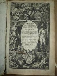
162531.185Bruselas: Ivan de Meerbeque 1625. 1ª ed. Pergamino. . 20x30.8. Hermosa portada grabada. Ivan de Meerbeque unknown
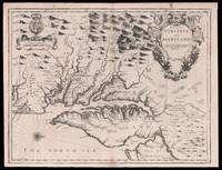
167615097London : Thomas Basset & Richard Chiswell 1676. 390 by 500mm. 15.25 by 19.75 inches. Sheet size 400 by 520mm 15.75 by 20.5 inches. Engraved map text on verso. Publishers Thomas Bassett and Richard Chiswell republished English cartographer John Speed's 1552-1629 popular 1611 atlas "The Theatre of the Empire of Great Britain" in 1676. As a supplement they included new section "A Prospect of the most Famous parts of the World" which contained maps engraved by Francis Lamb of the English colonies of New England and New York Virginia and Maryland Carolina and Florida and Jamaica and Barbados. This map separates Virginia and Maryland from New England and New York to show this area in greater detail and it also includes a small part of northern Carolina. It is the ninth and last derivation of John Smith's general outline of the area from 1612. The map is updated to incorporate details from Augustine Herrman's "Virginia and Maryland As it is Planted and Inhabited this present Year 1670". Although Herrman's publication bore a royal Privilege it did not protect the map from being copied particularly in the naming of the places and landmarks and a clearer delineation of the shore of the north-eastern part of the Chesapeake Bay. Hermann's map did not include specific borders however he did include a double line of trees showing the division of Virginia and Maryland on the Eastern shore from the 1668 border settlement which is also included on the present map. The text on the verso includes descriptive information on the region and is condensed from John Ogilby's "America". Burden 456 state 1 Tooley p170 Derivative 9 state 1 Thomas Basset & Richard Chiswell, unknown