Mallet, Alain ManessonBiblio.com
56 résultats
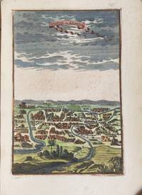
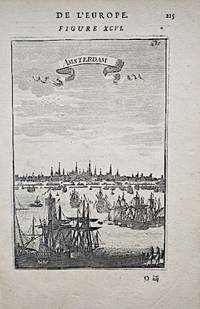
1683M16085.75" x 4.25"-14.6 x 10.7 cm. Copperplate engraving. Fine. A charming early view of Amsterdam Netherlands with ships in the foreground and the town in the background. Economic prosperity abounded during the 17th century coining it the "Golden Age" for Dutch culture. Much of this wealth stemmed from sea trade both within Europe and overseas in Africa Asia and the Americas. The economic boom resulted in more canals being created around the city for the quick transportation of goods. Published in Mallet's "Description de l'Univers",
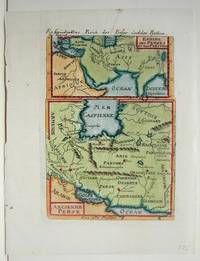
1686M18871686. Excellent; some light age toning. Size : 157x110 mm 6.125x4.375 Inches Coloring: Hand Colored Category: ; Maps Asia Middle East Iran Iraq unknown
1690M1872Paris c.1690. Very Good. Size : 150x105 mm 5.875x4.125 Inches Coloring: Hand Colored Category: ; Maps Asia Middle East Iran Iraq unknown
162446861624 16x24 cm, broché, 188 pages, excellent état, Collection Ascendances de la Revue de Géographie Alpine, numéro hors-série, cartes, figures, graphiques, reproductions et photographies en N&B uniquement, beau papier glacé, ISBN : 2903095299
162446941624 16x24 cm, broché, 280 pages, excellent état, Collection Ascendances de la Revue de Géographie Alpine, numéro hors-série, cartes, figures, graphiques, reproductions et photographies en N&B uniquement, papier glacé, photographie de couverture de Alain Morel, bibliographie en fin d'ouvrage, ISBN : 2903095256
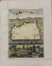
1686M1886Germany 1686. Excellent. Notes: 17th century map of Baghdad. Size : 155x115 mm 6.125x4.5 Inches Coloring: Hand Colored Category: ; Maps Asia Middle East Iran Iraq unknown
1686M18331686. Very Good. Size : 150x113 mm 5.875x4.5 Inches Coloring: Hand Colored Category: ; Maps Europe Switzerland; Maps City Maps unknown
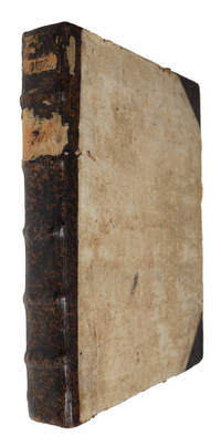
168561394Franckfurt am Mayn Zunner 1685. 4to. In contemporary half calf. Traces from old paper-label to spine. Binding with considerable wear. Back board broken but still attached. Inner hinges split. Frontispiece partly detached. Previous owner's name in contemporary hand to spine. With a few occassional brownspots and tears in margin but internally generally nice and clean. 8 210 14 pp. 128 engraved plates and 1 frontispiece. plates are numbered consecutively from 1 - 130. Plate no. 90 and 92 are missing but collation corresponds to the digitalized copy in Regensburg Staatliche Bibliothek OCLC Accession No: 930342403 and the Otto Leopold Schmidt-copy sold at Bonham in 2020. <br/><br/><em>First German translation vol. 4 only of Mallet’s lavishly illustrated ambitious guide to Europe offering geographical and cultural knowledge to a broader audience in part because of the numerous and detailed engravings. Mallet's maps and illustrations are not only geographically informative but also a fine example of the baroque style of the period. It has been suggested that his background as a teacher led to him being concerned with entertaining his readers. This concern manifested itself in these charming illustrations which include maps cityscapes and depictions of various cultural practices and costumes. The first edition appeared in Paris in 1683 as "Description de l'univers" and soon after the hundreds of copper plates for the illustrations were transferred to Jan David Zunner in Frankfurt who published the first edition of the German translation in 1684 with German text engraved in the plates. He then published the second French edition in 1685 with the German text still in the plates. Alain Manesson Mallet 1630–1706 was a French cartographer and engineer primarily known for his significant contributions to cartography particularly through the present work. He began his career as a soldier in the army of Louis XIV eventually rising to the rank of Sergeant-Major in the artillery and serving as an Inspector of Fortifications. Mallet also served under the King of Portugal before returning to France where he was appointed to the court of Louis XIV. His expertise in military engineering and mathematics earned him a position teaching mathematics at the royal court. For the original in French see: Brunet III 1343 and Sabin 44130 and Graesse IV 354. </em> unknown
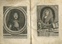
168429632AB1684. 1. Band von 5. Franckfurt Johann David Zunner 1684. 1 gestochener Titel 2 gestochene Portraits 110 von 113 Kupfertafeln 4 Bl. 138 S. 5 Bl. Register. Pappband der Zeit Kanten stärker bestoßen oberes Kapital fixiert. 1. deutschspr. Ausgabe. - VD17 39:129238W; vgl. Sabin 44130; Poggendorff II 26; Graesse IV 353 f; Houzeau & L. I 8800 frz. EA von 1683. - Der Kartograph und Ingenieur Mallet 1630-1706 beschreibt in 5 Teilen die "Sitten Religionen und Regierungsarten" Mallet verschiedener Nationen aller Kontinente. Dieser erste Teil ist von besonderer wissenschaftsgeschichtlicher Relevanz denn er fasst einleitend das astronomische und meteorologische Wissen der Zeit zusammen. Es folgt die Beschreibung der unterhalb des Nordpols gelegenen Länder. Die zahlreichen Kupfertafeln zeigen vornehmlich Motive aus der Astronomie sowie Landkarten aber auch Darstellungen aus der beschriebenen Region. - Mit beiden Portraits Ludwig XIV und Mallet die laut VD17 öfter fehlen. Nicht enthalten sind die Tafeln Nr. 15 80 u. 81. Vorsatz mit Besitzvermerken von alter Hand Titelblatt verso und S. 100 gestempelt. Durchgehend etwas stockfleckig. S. 135 mit größerer Fehlstelle. unknown
168561394Franckfurt am Mayn, Zunner, 1685. 4to. In contemporary half calf. Traces from old paper-label to spine. Binding with considerable wear. Back board broken but still attached. Inner hinges split. Frontispiece partly detached. Previous owner's name in contemporary hand to spine. With a few occassional brownspots and tears in margin, but internally generally nice and clean. (8), 210, (14) pp. + 128 engraved plates and 1 frontispiece. (plates are numbered consecutively from 1 - 130. Plate no. 90 and 92 are missing, but collation corresponds to the digitalized copy in Regensburg, Staatliche Bibliothek, OCLC Accession No: 930342403 and the Otto Leopold Schmidt-copy, sold at Bonham in 2020).
1686M10391686. Very Good; some smudges on the left hand margin. Notes: From German Edition of "Description de l'Univers" Size : 101x157 mm 4x6.125 Inches Coloring: Hand Colored Category: Maps South America Countries; unknown
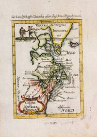
1685M11010Germany 1685. Very Good. Notes: From German Edition of "Description de l'Univers"<br>Map of Eastern North America<br><br> Size : 160x105 mm 6.30x4.13 Inches Coloring: Hand Colored Reference: Burden #565; Kershaw #267 Category: Maps Canada East; Maps United States East States; unknown
1686M15261686. Good. Notes: From German Edition of "Description de l'Univers" Size : 165x115 mm 6.5x4.5 Inches Coloring: Hand Colored Category: Maps Central America Countries; Maps South America Countries; unknown
1684M1826Paris: Thierry Denys 1684. Excellent. Size : 145x102 mm 5.75x4 Inches Coloring: Hand Colored Category: Maps Africa East Thierry, Denys unknown
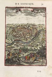
1683M10552Paris c.1683. Very Good. Size : 150x105 mm 5.91x4.13 Inches Coloring: Hand Colored Category: Maps City Maps; Maps Africa North Egypt; unknown
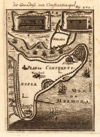
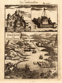
168628645Frankfurt: Jean David Zunner 1686. Other. A strong impression uncolored as published. In excellent condition. 150 by 111mm 6 by 4¼ inches. Copper engraving published in Allain M. Mallet's description of the world 'Description De L' Univers Contenant Les Differents Systemes Du Monde Les Cartes generales & particulieres.'. French text edition with additional German titles on top. Decorative birds eye plan of Constantinoples with port of Constantinoples Galata and the Marmara sea. Engraved ships and buildings. Jean David Zunner unknown
1686M18561686. Very Good; some light occasional browning. Size : 161x123 mm 6.375x4.875 Inches Coloring: Hand Colored Category: ; Maps Europe Italy unknown
168628646Frankfurt: Jean David Zunner 1686. Other. A strong impression uncolored as published. In excellent condition. 145 by 104mm 5¾ by 4 inches. Copper engraving published in Allain M. Mallet's description of the world 'Description De L' Univers Contenant Les Differents Systemes Du Monde Les Cartes generales & particulieres.'. French text edition with additional German titles on top. Jean David Zunner unknown
1652179691652 broché - 16.5x23 -32 pp - 1984- éditions OUEST FRANCE - illustrations hors texte
1652179711652 broché - 16.5x23 -32 pp - 1984- éditions OUEST FRANCE - illustrations hors texte
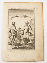
1683175636Netherlands. Circa1683. Copper engraving 14.6 x 9.5 cm with a caption in Dutch at the head a little browned at the margins but in good condition. Prepared as plate LXIII for Manesson's five volume "Description de L'Univers" a representation with classical flourishes of inhabitants of the Sonde Sunda Islands. . unknown
1686M18711686. Excellent; one or two small light browning spots. Size : 163x112 mm 6.375x4.375 Inches Coloring: Hand Colored Category: ; Maps Asia Middle East Iran Iraq unknown
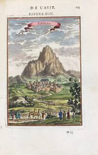
1683M11125Paris 1683. Very Good. Notes: 17th century copperplate French view of Erivan Yerevan Armenia. <br>French text on verso. Size : 150x105 mm 5.91x4.13 Inches Coloring: Hand Colored Category: Maps Asia Middle East Caucasus; unknown
1686M18581686. Very Good. Size : 170x125 mm 6.75x4.875 Inches Coloring: Hand Colored Category: ; Maps Europe Italy unknown
1684M1503Paris: Thierry Denys 1684. Very Good. Size : 145x105 mm 5.75x4.125 Inches Coloring: Hand Colored Category: Maps South America Countries; Thierry, Denys unknown