Mallet, Alain ManessonBiblio.com

56 résultats
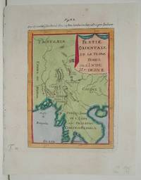
1684M1060Paris: Thierry Denys c. 1684. Very Good. Size : 152x104 mm 6x4.125 Inches Coloring: Hand Colored Reference: Maryland State Archives Category: Maps United States East States; Thierry, Denys unknown
1686M7129Germany c. 1686. Very Good;. Size : 146x103 mm 5.75x4.06 Inches Coloring: Hand Colored Category: Maps Europe Balkans; Maps Europe Greece Macedonia; unknown
1684M1525Paris: Thierry Denys 1684. Excellent. Size : 152x110 mm 6x4.375 Inches Coloring: Hand Colored Category: ; Maps United States South Florida; Maps City Maps Thierry, Denys unknown
161781991617 Paris, Revue Obliques n°16-17, 1972, in-4 broché, 352 pp; nombreuses illustrations dont 16 planches hors-texte en couleurs, bibliographie. Textes de Alain Robbe-Grillet, Olivier-René Veillon, Philippe Sollers, Bruce Morrissette, Colette Astier, Maurice Blanchot, Gerard Genette, Jean Ricardou, André Gardies etc.
1686M18571686. Very Good; some light age toning. Size : 162x120 mm 6.375x4.75 Inches Coloring: Hand Colored Category: ; Maps Europe Italy unknown
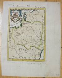
1686M7065Germany 1686. Very Good;. Notes: From German Edition of "Description de l'Univers". Size : 150x108 mm 5.91x4.25 Inches Coloring: Hand Colored Category: Maps Europe Poland Lithuania; unknown
168395181683. Very Good. Minor edge toning else bright and clean. <br/><br/>Copper plate engraving. unknown books
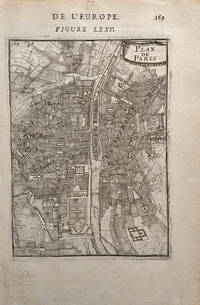
1683M1593Copperplate engraving. This map was engraved by French cartographer/military engineer Alain Manesson Mallet. He was active in the mid to late 17th century. A bird's eye view of the city of Paris showing the Siene River various " quartiers" and major public buildings such as the Louvre and the Tuilleries. The peripheries are farmland and forests. Published in Mallet's "Description de l'Univers"
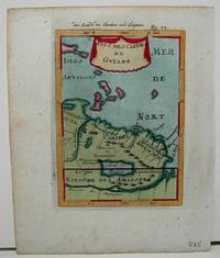
1686M7071686. Good; some discoloration of margins; one browning spot on upper margin. Notes: From German Edition of "Description de l'Univers" Size : 155x105 mm 6.125x4.125 Inches Coloring: Hand Colored Category: Maps South America Countries; unknown
1686M7061686. Very Good. Notes: From German Edition of "Description de l'Univers" Size : 155x110 mm 6.125x4.375 Inches Coloring: Hand Colored Category: Maps South America Countries; unknown
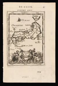
1686M1888Paris 1686. Excellent. Size : 160x110 mm 6.25x4.375 Inches Coloring: Hand Colored Category: ; Maps Asia Continent unknown
1686M18821686. Excellent. Size : 158x110 mm 6.25x4.375 Inches Coloring: Hand Colored Category: Maps Asia South East unknown
1686M18771686. Excellent. Size : 150x105 mm 5.875x4.125 Inches Coloring: Hand Colored Category: ; Maps Asia Near East Turkey unknown
1686M10381686. Good; some darkening in the lower right margin; and two light browning spots on the left margin. Notes: From German Edition of "Description de l'Univers" Size : 150x105 mm 5.875x4.125 Inches Coloring: Hand Colored Category: Maps Central America Mexico; Maps City Maps unknown
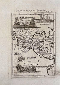
16858214One uncolored miniature copper-engraved map of southern North America also depicting Florida extending through Central America. A large cartouche to top along with vignettes of sea battle in the Pacific and Native American battle in the region of Louisiana. This is the second state with a German title above the map "Mexica oder Neu Spannien" published in Johann David Zunner's edition of Mallet's Description de l'Universe. A nice clean copy. The map measures 3.9 x 5.6 inches 9.9 x 14.2 cm while the page is 5.5 x 7.5 in.
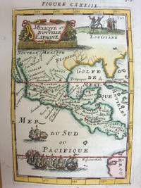
1686M7067Paris 1686. Very Good;. Notes: From French Edition of "Description de l'Univers". Size : 148x102 mm 5.83x4.02 Inches Coloring: Hand Colored Category: Maps Central America Mexico;Maps United States South; unknown
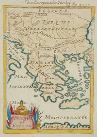
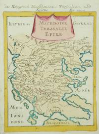
1686M7128Germany c. 1686. Very Good;. Notes: Map of Macedonia.<br>Mallet Alain Manesson 1630-1706 was an important French geographer and military engineer at the time of King Louis XIV. Size : 160x116 mm 6.30x4.57 Inches Coloring: Hand Colored Category: Maps Europe Greece Macedonia; unknown
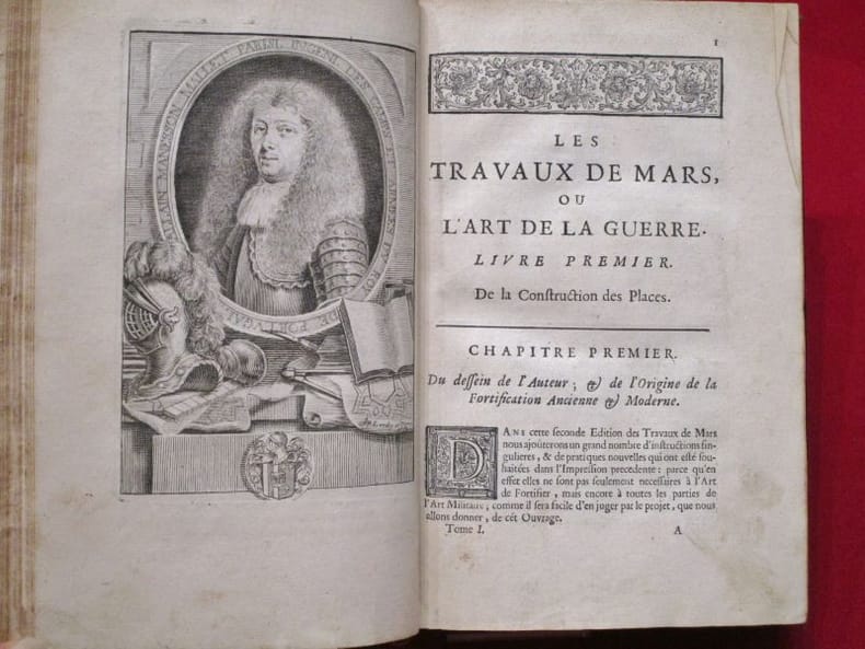
161714760Paris Imprimerie de Pierre Le-Mur (pour Samuel Thiboust) 1617 Fort volume in-4 veau marbré de l'époque, dos à nerfs orné de fers dorés, dauphin couronné doré en queue, double filet doré encadrant les plats, armes au centre. (14) pp-868 pp. et (20) pp. (Page de titre rogné court dans la partie inférieure, avec perte de quelques lettres au bas, mors supérieur et coiffes restaurés).
1685114486Denys thierry 1685 A Paris, Chez Denys Thierry, 1685, 1 volume in-8 de 135 x 215 mm, (12) ff., 363 pages, (2) ff. (Table). Tome I seul sur 3, contient 2 frontispices et 155 planches. Pleine reliure d'époque, dos à 5 nerfs portant tires et tomaisons dorés, roulette dorée sur les coupes, gardes blanches. Coiffes, coins et un mors abimés, quelques manques de cuir, quelques rousseurs, de rares déchirures en marge (sans atteinte au texte), bon état général.
168457949ABBand 2 (von 3). Paris, Chez Denys Thierry. 1684. Klein-4°. Gestochener Titel, 6 n.n.Bll., 341 S. mit 120 Abbildungen, 3 n.n.S.table. Lederband der Zeit mit goldgeprägtem Rückentitel, reicher floraler Rückenvergoldung
169056974Description de l'Univers. c.1690. Plan of the city of San Juan Puerto Rico one of the biggest and best natural harbours in the Caribbean. Copper engraving. Later colour. Fine condition. Slight offsetting. Size: 11 x 15 cm. 4½ x 6 inches unknown
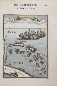
1684M1519Paris: Thierry Denys 1684. Very Good;. Notes: 17th Century French map of Cuba and the Bahamas Lucayan Archipelago.<br>Mallet Alain Manesson 1630-1706 was an important French geographer and military engineer at the time of King Louis XIV. Size : 150x106 mm 5.875x4.125 Inches Coloring: Hand Colored Category: Maps West Indies Cuba & Bahamas; Thierry, Denys unknown
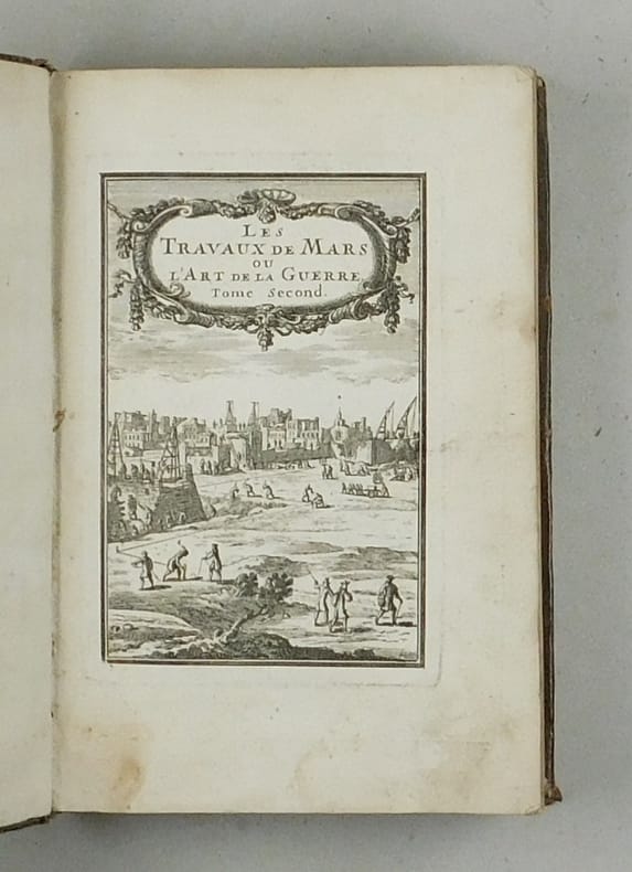
168315889Paris: Chez Denys Thierry 1683. 210 by 139mm. 8.25 by 5.5 inches. Engraved map French text on verso. From the second volume of Manesson-Mallet's five volume description of the world 'Description de L'Univers' published first in 1683 in French and then again in French and German in 1684 and 1685 followed by a final German edition of 1719. Manesson-Mallet 1630-1706 was an engineer in the service of the King of Portugal. On his return to France he was appointed Master of mathematics to the pages of King Louis XIV. In addition to his history of the world he also wrote a book about fortifications 'Les Travaux de Mars' and another about surveying and mapmaking 'La Geometrie Pratique divisee en quatre livers' Hubbard 50. Chez Denys Thierry, unknown
1686M18841686. Excellent. Size : 150x105 mm 5.875x4.125 Inches Coloring: Hand Colored Category: ; Maps Asia South East Indonesia & Papua New Guinea unknown
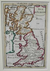
1684M1837Paris 1684. Excellent. Size : 155x105 mm 6.125x4.125 Inches Coloring: Hand Colored Category: ; Maps Europe United Kingdom unknown