1 372 résultats
186064001London UK: William Tweedie 337 Strand 1860. Small 4to. 5.25 x 7.5 in. xv 1 3-172 xi 1 pp. Woodcut-engraved frontisp. of the author still preserving tissue guard. Publisher’s ribbed plum-coloured cloth dark maroon coloured title label & price of 1 shilling 6 pence mounted front cover very minor chipping head & foot of spine slight fraying title label stamping dimmed and minor bumping to a couple corners still a VG copy w/ London UK bookseller’s label partially removed at gutter margin front pastedown. First edition first printing of the first book wholly devoted to the Underground Railroad published only in England and by an African-American/Native-American author. Mitchell was a pivotal figure in the Underground Railroad who also aided the escaped slave “Eliza†whose escape over the Ohio River ice inspired the key dramatic moment in Harriet Beecher Stowe’s pivotal Uncle Tom’s Cabin. “Eliza†was sheltered originally in the network by noted abolitionist John Rankin passed on to Mitchell who then subsequently ensured her safe passage along the network overseen by Levi Coffin 1798-1877. Ironically the passage of the 1850 Fugitive Slave Act which criminalized those aiding in the Underground Railroad to free slaves with fines of $ 1000 and six months imprisonment fueled resistance and forced Mitchell to publish this seminal work in Great Britain rather than the U.S. As a freeborn orphan Black in North Carolina Mitchell was forced into apprenticeship with a North Carolina plantation owner where he witnessed the deprivations of slavery and became inspired to aid African-American slaves to escape to Canada. From 1842-1855 he helped over 1300 slaves reach Canada from his Washington Court House Fayette County Ohio way station. This memoir recounts many anecdotes of the formerly enslaved including: one enslaved woman who died from frostbite while protecting her three children and a former slave John Mason brought Mitchell in just 19 months of that 13 year span “265 human beings whom he had been instrumental in redeeming from slavery.†Mitchell further recounts Mason’s recapture in Kentucky and later escape from New Orleans to Canada. Mitchell estimates in his book that 60000 enslaved peoples escaped into Canada on the Underground Railroad modern estimates range from 40000 to 100000. At the end of the 1850’s he moved to Toronto and began serving as a minister to African-American Baptist Free Mission congregations largely composed of freed slaves and the final section details the lives of these Canadian Black immigrants. In the final appendix he urgently pleads for a boycott of Southern cotton by Great Britain attempting to overcome resistance to the economic impact and hardship it would have on British cotton mills and related industries. Mitchell c. 1826-c.1879 was encouraged to write this historic work by W.H. Bonner A British abolitionist and had toured Britain in 1860 with William Howard Day and British abolitionist George Thompson to oppose the condition of slavery before the outbreak of the Civil War. This work is quite scarce with only 2 copies at auction in the last 50 years and both those appear to have been the 2nd edition which removed the hyphen in “Under-Ground†extended the title and a couple other revisions. William Tweedie, 337, Strand, hardcover
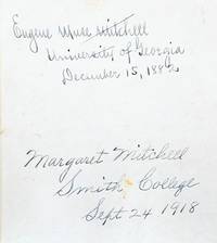
1882176004Boston: Ginn Heath & Co. 1882. A glimpse into Mitchell's family life and thwarted education A resonant literary artefact from a formative period of Mitchell's life: her family's copy of a dictionary used in her early days at Smith College and inscribed by her upon enrolment. A gift from her father a prominent Atlanta lawyer and historian it is inscribed by both generations on the front pastedown: "Margaret Mitchell Smith College Sept. 24 1918" and above her father's inscription from his own university days: "Eugene Muse Mitchell University of Georgia December 15 1882". Both father and daughter have practised their signatures elsewhere in the volume. It was Mitchell's suffragist mother May Belle Stephens Mitchell who encouraged her to attend Smith the prestigious female liberal arts school; she wanted her daughter to be educated as preparation for life's vagaries. May Belle loomed large as a figure of admiration and influence in Mitchell's early years but she did not live to witness the fruits of her daughter's schooling and the literary success of Gone with the Wind. In 1919 she died of influenza. This and the death of Mitchell's fiancé in action during the First World War prompted Mitchell to abandon her studies after her freshman year. She left Massachusetts and returned to the South to assume a role in her family's household supporting her father and stepping into her mother's role of a society hostess. 2 works in 1 octavo 188 x 140 mm presumably issued thus. Early 20th-century black textured coated cloth cloth labels lettered in manuscript. Housed in a custom green half morocco slipcase. Annotations to rear blank and throughout in an unidentified hand. Spines ends worn repair to covers inner hinges strengthened with linen spine labels toned and lifting slightly couple of small damp stains to edges loss to lower outer corner of first title page small tear to pp. 246-7 in second work contents toned. hardcover
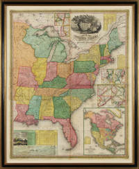
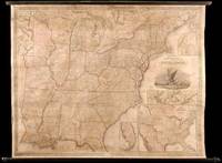
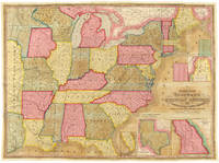
183122138Philadelphia 1831. No binding. Fine. Map of the United States. Entered according to Act of Congress in the Clerks Office of the Eastern District of Pennsylvania October 10th 1831. Philadelphia 1831. Folding map on four sheets joined. Folding into original covers 8vo binding size: 9 5/8 x 6 1/2 in. red half morocco over marbled paper boards upper cover with gilt-lettered title label corner and edges worn. The map and covers now apart and separately mounted for display. Historical BackgroundFirst edition and the first wall map issued by Mitchell. This edition does not have the counties delineated and numbered. Ristow mistakenly says all editions have the townships he means counties numbered but this one the first does not thereby eliminating the index of counties and thus showing more of the western territory. This map predates the Traveler's Guide by 1 year and thus is Mitchell's first ""original"" production as opposed to the Finley material he reissued as the American Atlas and Pocket Maps. Copyright date is October 10 1831. There is no other date on the map. Ristow thinks the map was issued in early 1832 but it is not in Phillips until 1834 edition which probably has the counties indicated by number and the 1831 copyright so Ristow may not have seen this edition but rather the 1834.ReferenceKarrow 1-1473; Ristow p309.ConditionOriginal full color the palette rich and bright. One 5-inch repaired tear at left into Arkansas some cracking and more minor tears at folds. Some overall browning of the sheet. In good condition.
183122138Philadelphia 1831. No binding. Fine. Map of the United States. Entered according to Act of Congress in the Clerks Office of the Eastern District of Pennsylvania October 10th 1831. Philadelphia 1831. Folding map on four sheets joined. Folding into original covers 8vo binding size: 9 5/8 x 6 1/2 in. red half morocco over marbled paper boards upper cover with gilt-lettered title label corner and edges worn. The map and covers now apart and separately mounted for display. Historical BackgroundFirst edition and the first wall map issued by Mitchell. This edition does not have the counties delineated and numbered. Ristow mistakenly says all editions have the townships he means counties numbered but this one the first does not thereby eliminating the index of counties and thus showing more of the western territory. This map predates the Traveler's Guide by 1 year and thus is Mitchell's first ""original"" production as opposed to the Finley material he reissued as the American Atlas and Pocket Maps. Copyright date is October 10 1831. There is no other date on the map. Ristow thinks the map was issued in early 1832 but it is not in Phillips until 1834 edition which probably has the counties indicated by number and the 1831 copyright so Ristow may not have seen this edition but rather the 1834.ReferenceKarrow 1-1473; Ristow p309.ConditionOriginal full color the palette rich and bright. One 5-inch repaired tear at left into Arkansas some cracking and more minor tears at folds. Some overall browning of the sheet. In good condition. books
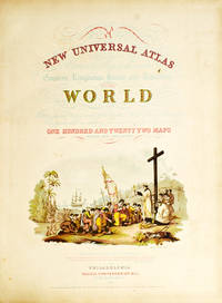
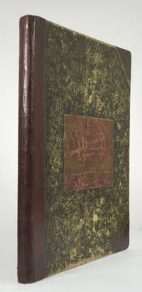
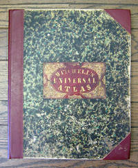
1852236680Philadelphia: Thomas Cowperthwait & Co 1852. Chromolithograph title hand-colored frontispiece 73 hand-colored lithographic maps. 1 vols. Folio. Half red morocco in period style original marbled boards with printed label on upper cover very clean. Chromolithograph title hand-colored frontispiece 73 hand-colored lithographic maps. 1 vols. Folio. Mitchell & Sons first published their NEW UNIVERSAL ATLAS in 1846 having acquired Tanner's NEW UNIVERSAL ATLAS in 1845 and printed it several times subsequently until 1850 when the firm sold the rights to Cowperthwait & Co. of Philadelphia who published it until 1856 continually adding to and editing the hand-colored maps. Despite the attribute "Universal" in the title the Atlas clearly concentrates on America with 43 maps of the continent and features a large double-page transcontinental map of the U.S; and this 1852 Cowperthwait edition is the first to show counties in California and New Mexico. Phillips 809; Ristow pp.311-13; Rumsey p.240 Thomas, Cowperthwait & Co unknown
1852236680Philadelphia: Thomas Cowperthwait & Co 1852. Chromolithograph title hand-colored frontispiece 73 hand-colored lithographic maps. 1 vols. Folio. Half red morocco in period style original marbled boards with printed label on upper cover very clean. Chromolithograph title hand-colored frontispiece 73 hand-colored lithographic maps. 1 vols. Folio. Mitchell & Sons first published their NEW UNIVERSAL ATLAS in 1846 having acquired Tanner's NEW UNIVERSAL ATLAS in 1845 and printed it several times subsequently until 1850 when the firm sold the rights to Cowperthwait & Co. of Philadelphia who published it until 1856 continually adding to and editing the hand-colored maps. Despite the attribute "Universal" in the title the Atlas clearly concentrates on America with 43 maps of the continent and features a large double-page transcontinental map of the U.S; and this 1852 Cowperthwait edition is the first to show counties in California and New Mexico. Phillips 809; Ristow pp.311-13; Rumsey p.240 Thomas, Cowperthwait & Co unknown books
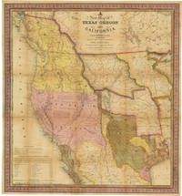
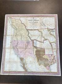
1846WRCAM32518CPhiladelphia: S. Augustus Mitchell 1846. 46pp. text plus colored folding map 22 1/2 x 20 3/4 inches. 18mo. Original gilt morocco cover neatly rebacked in matching morocco. Map neatly repaired with tissue on folds. Text is clean. A major western map with accompanying text. The detailed "New Map of Texas Oregon and California with the Regions Adjoining." shows the western portion of the U.S. to the Pacific with Indian Territory Missouri Territory Iowa and portions of the states of Missouri Arkansas Louisiana and Wisconsin as well as northern Mexico and part of British Columbia illustrating in detail the trans-Mississippi region on the verge of the Mexican-American War. Texas is elaborately depicted with the Rio Grande as its southern border; Oregon is shown to extend to 54° 40"; and the Santa Fe Trail and the Oregon Trail are both detailed the latter with a table of distances published in the lower corner of the map. "This map represents a great step forward in that it is among the first by a commercial cartographer to utilize the recent explorations that had bounded and determined the nature of the Great Basin.because of its popularity this map of the West exerted great influence not only with the public but on other commercial cartographers" - Wheat. The text describes each territory or state in turn with notes on Lewis and Clark and other early explorers and more historical material. Howes also mentions an issue with thirty-four pages of text but Sabin lists only the present collation. HOWES M685 "aa." SABIN 49714. MARTIN & MARTIN 36. WAGNER-CAMP 122b. COWAN p.433. WHEAT TRANSMISSISSIPPI 520. STREETER SALE 2511. PHILLIPS MAPS p.844. WHEAT GOLD REGIONS 29. REESE BEST OF THE WEST 91. S. Augustus Mitchell unknown books
185949436Philadelphia: S. Augustus Mitchell 1859. Large hand-colored wall map on rods approx. 64" square with 4 engraved vignettes 3 inset maps 2 of the world and 1 of the Sandwich Islands all within an elaborate floral border; some infill along the margins slight loss in the population tables at the bottom and several cracks in the paper the whole neatly and professionally backed with linen; overall appearance is certainly very good or better with the usual small defects. America as it was on the eve of the Civil War. OCLC records examples from 1856 1857 1858 1860 and 1861 but not this. Unusual features of this map include the Shoshone Territory what is now mostly Idaho Colona now part of Colorado the unusually large Nebraska the horizontal Utah and New Mexico and the unusually small Dakotas. <br/><br/> S. Augustus Mitchell unknown books
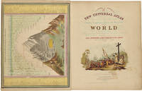
18525810Philadelphia: Thomas Cowperthwait & Co 1852. Folio. 17 x 13 3/4 inches. Chromolithographic title with large vignette hand-coloured frontispiece of the heights of the principal mountains and lengths of the principal rivers contents list printed in red black and gold 73 hand-coloured lithographed maps charts and city plans 1 double-page. Publisher's green marbled paper-covered boards with morocco title label elaborately tooled and lettered in gilt on upper cover red morocco spine and corners expertly renewed to style. Modern red cloth box morocco lettering piece<br/> <br/>A fine copy of this famous atlas with hand-coloured maps of all the individual States and Territories. The map of California shows counties in California and New Mexico for the first time.<br/> <br/>Despite its title the Atlas concentrates to a marked degree on the American continent with 43 maps of the area including a fine double-page east-to-west-coast map of the United States. S. Augustus Mitchell and his sons were the leading publishers of maps in the United States during most of the nineteenth century. Mitchell had come to Philadelphia around 1830 with the intention of improving the standard of geography textbooks Philadelphia then being the leading city in America for cartographical publications. A New American Atlas published in 1831 was his first work. In 1845 he acquired the rights to Tanner's New Universal Atlas first published in 1836 and in 1846 he published his first edition of the present work. Mitchell continued to publish the atlas until 1850 when he sold the copyright to Cowperthwait & Co. of Philadelphia. Thomas Cowperthwait & Company published it until the mid-1850s when it was purchased by Charles De Silver. The Cowperthwait company continued to add edit alter and hand-colour the maps.<br/> <br/>Phillips Atlases 807; cf. Ristow pp. 311-313; Rumsey p.239. Thomas, Cowperthwait & Co unknown books
18556365Philadelphia: Charles DeSilver 1855. Folio. 17 x 14 inches. Chromolithographic title with large vignette hand-coloured frontispiece of the heights of the principal mountains and lengths of the principal rivers contents list printed in red black and gold 71 hand-coloured lithographed maps and charts 3 double-page and 1 city plan. Publisher's red half morocco with green marbled paper-covered boards morocco title label elaborately tooled and lettered in gilt on upper cover. Modern red cloth box dark red morocco lettering piece<br/> <br/>A fine copy of this famous atlas with hand-coloured maps of all the individual States and Territories. The first edition to have DeSilver as publisher and here including 'A New Map of Nebraska Kansas New Mexico & the Indian Territories' for the first time: present here as an additional map un-numbered and not called for in the contents list<br/> <br/>Despite its title the Atlas concentrates to a marked degree on the American continent with a city plan of Washington D.C. and 42 maps of the area including a fine double-page coast-to-coast map of the United States and 30 maps of the States and Territories. The un-numbered map of Nebraska Kansas etc. is here bound between sheets numbered 37 and 38. S. Augustus Mitchell and his sons were the leading publishers of maps in the United States during most of the nineteenth century. Mitchell had come to Philadelphia around 1830 with the intention of improving the standard of geography textbooks Philadelphia then being the leading city in America for cartographical publications. A New American Atlas published in 1831 was his first work. In 1845 he acquired the rights to Tanner's New Universal Atlas first published in 1836 and in 1846 he published his first edition of the present work. Mitchell continued to publish the atlas until 1850 when he sold the copyright to Cowperthwait & Co. of Philadelphia. Thomas Cowperthwait & Company published it until the mid-1850s when it was purchased by Charles De Silver. The Cowperthwait company continued to add edit alter and hand-colour the maps.<br/> <br/>Phillips Atlases 6118; cf. Ristow pp. 311-313; Rumsey pp.240-241. Charles DeSilver unknown books
184687887Philadelphia PA: S. Augustus Mitchell 1846. Map. Good Plus. Folding lithographic map 22.75 in. x 21 in. with original color. Map is laid flat in archival plastic and will be securely protected and shipped in a mailing tube. Tanning to seams. Tape repairs and reinforcement on verso to all seams. Tiny losses of paper at six seam junctions. Storm 2841. Wagner-Camp 122b. <br /> <br /> This is Mitchell's third map of Oregon the first being "Oregon and California" published in Mitchell's ;School and Family Geography; and the second being "Mexico and Guatemala" which includes Upper or New California New Mexico and Texas." Wheat Mapping The Transmississippi West 520. Carl Wheat described it as: ".a work of real importance highly popular and.on it the influence of the War wioth Mexico is strikingly revealed.It was among the first by a commercial cartographer to utilize the recent explorations that had bounded and determined the nature of the Great Basin. The Texas claim to a western boundary up the Rio Grande is here shown with the northern panhandle extending all the way to the 42nd parallel.Because of its popularity this map of the West exerted great influence not only on the public but on other commercial cartographers." "The region covered by the map was of particular interest in 1846 because of two recent and related events. In 1845 Texas was admitted into the Union which prompted Mexico to invade Texas in 1846 thus precipitating the U.S.-Mexican war. General curiosity about the new State of Texas and interest in the war with Mexico led to Mitchell's timely map becoming quite popular. Mitchell used the latest and best sources for the map including Arrowsmith's 1841 map of Texas Fremont's and Emory's maps of their explorations in the region data from the Lewis & Clark expedition Nicollet's map of the region between the Mississippi River and the Missouri River Wilkes map of Oregon. <br /> <br /> Among other significant uses of the map Brigham Young ordered 6 copies of the map and an example in the BYU collection includes an annotation placing the Mormons in Utah pre-dating Fremont's map of 1848 which is the first printed map noting the presence of the Mormons in the Great Basin. <br /> <br /> The map shows Texas's claims to the Upper Rio Grande in present-day New Mexico -- eventually given up as part of the Great Compromise of 1850 in exchange for the U.S. Federal Government's assumption of Texas's public debt. One of the most influential maps in Western American History." from Stanford University Library. S. Augustus Mitchell unknown
185949436Philadelphia: S. Augustus Mitchell 1859. Large hand-colored wall map on rods approx. 64" square with 4 engraved vignettes 3 inset maps 2 of the world and 1 of the Sandwich Islands all within an elaborate floral border; some infill along the margins slight loss in the population tables at the bottom and several cracks in the paper the whole neatly and professionally backed with linen; overall appearance is certainly very good or better with the usual small defects. America as it was on the eve of the Civil War. Unusual features of this map include the Shoshone Territory what is now mostly Idaho Colona now part of Colorado the unusually large Nebraska the horizontal Utah and New Mexico and the unusually small Dakotas. Phillips Maps of America lists only the 1856 edition. OCLC records examples from 1856 1857 both on conjoined sheets 1858 1860 and 1861 but not this. S. Augustus Mitchell unknown
181969865Atlanta Georgia August 18 1936. attractively matted and framed with the envelope to an overall size of about 20 x 16 inches. . Light horizontal creases where folded to fit the envelope; otherwise very fine. 10-1/2 x 7 inches. Mitchell thanks her correspondent for her kind remarks about "Gone With the Wind" and the verisimilitude of her characters: "I know no higher compliment that can be paid to an author." Her second paragraph discusses the novel's ending and the future of Scarlett and Rhett and concludes "I do hate to write. Just now I feel that I will never write anything again." unknown
1852WRCAM31820APhiladelphia: Thomas Cowperthwait & Co. 1852. Chromolithographic title with large vignette; handcolored frontispiece of heights of principal mountains and lengths of principal rivers; contents list printed in red black and gold; seventy-three handcolored lithographic maps charts and city plans one double-page. Folio. Publisher's three-quarter red morocco and marbled boards spine ruled in gilt morocco label lettered in gilt on front board. Binding worn and rubbed front hinge tender. Contemporary bookplate on front pastedown. Some toning but generally clean internally. Very good overall. A famous atlas with handcolored maps of all the individual states and territories with the map of California showing counties in California and New Mexico for the first time and with the locations of Native American tribes shown in several western states and territories. Despite its title the atlas concentrates to a marked degree on the American continent with forty-three maps of the area including a fine double-page coast- to-coast map of the United States. <br> <br> S. Augustus Mitchell and his sons were the leading publishers of maps in the United States during most of the 19th century. Mitchell had come to Philadelphia round 1830 with the intention of improving the standard of geography textbooks Philadelphia then being the leading city in America for cartographical publications. A NEW AMERICAN ATLAS published in 1831 was his first work. In 1845 he acquired the right to Tanner's NEW UNIVERSAL ATLAS first published in 1836 and in 1846 he published his first edition of the present work. Mitchell continued to publish the atlas until 1850 when he sold the copyright to Cowperthwait & Co. of Philadelphia. Thomas Cowperthwait & Company published it until 1856 when it was purchased by Charles DeSilver. The Cowperthwait company continued to add edit alter and hand-color the maps. PHILLIPS ATLASES 807. RISTOW pp.311-13 ref. RUMSEY 553. Thomas, Cowperthwait & Co. hardcover books
185265704With the First Map to Show Counties in California and New Mexico MITCHELL S. Augustus. A New Universal Atlas of the World. Containing Maps of the various Empires Kingdoms States and Republics Of The World. With a special map of each of the United States Plans of Cities &c. Comprehended in seventy sheets and forming a series of One Hundred And Seventeen Maps Plans And Sections Philadelphia: Cowperthwait & Co. 1852. Complete with seventy-three full colored maps one of which is double-paged color frontispiece vignette title-page and table of contents heightened in gilt. Folio 17 x 14 inches; 430 x 355 mm. Half red morocco over marbled boards. Front board with red morocco label lettered in gilt. Binding scuffed and bumped. Hinges professionally repaired. Some toning throughout mainly to blank versos of maps and margin edges only occasionally affecting the maps. Closed tear to front free endpaper. A few instances of foxing on maps mainly to map 51 "Holland and Belgium." A small dark spot in Buenos Ayres on map 44. A small piece scraped off of map 73 "Oceana" but not making a hole all the way through. Also a marginal closed tear to this map professionally repaired. Overall a very good copy. This atlas was first published in 1846 by Mitchell & Sons after acquiring the rights to Tanner's New Universal Atlas in 1845. Mitchell & Sons reprinted it several times until 1850 when they sold the rights to Cowperthwait & Co. of Philadelphia who published it until 1856. During this time the atlas was further expanded and edited. Over half of this atlas deals with the Americas and features the double-page "A New Map of the United States of America." Within this map of the USA is a detailed inset of "The Gold Regions of California." The present edition is the first to show counties in California and New Mexico. Howes. Streeter. HBS 65704. $7500 Cowperthwait & Co. hardcover books
18496558Philadelphia: S. Augustus Mitchell 1849 Folio. 17 3/8 x 14 inches. Lithographed title with large vignette letterpress "Table of Contents" and 73 hand-colored lithographed maps charts and city plans. Three-quarter red morocco over marbled boards large red morocco title label on front cover elaborately tooled and lettered in gilt. Spine and corners renewed in red leather. Boards rubbed and scuffed at edges. Maps in fine condition. Overall a fine copy. A very nice copy of this very scarce atlas with hand-colored maps of all the individual States and Territories and including the rare and famous map of "Oregon Upper California & New Mexico" showing the large yellow-colored area in California labeled "Gold Region." The Atlas concentrates on the American continent with 43 maps of the area including a fine double-page coast-to-coast map of the United States. Samuel Augustus Mitchell and his sons were the leading publishers of maps in the United States during most of the nineteenth century. A New American Atlas published in 1831 was Mitchell's first work. In 1846 he published his first edition of the present work. He continued to publish the Atlas until 1850 when he sold the copyright to Cowperthwait & Co. It was with this 1849 edition that "New Mexico" was added to the title of the map as well as the words "Gold Region" added in a large yellow area in "Upper or New California." As Wheat states "We find S. Augustus Mitchell in Philadelphia publishing in 1849 a revised version of his Texas Oregon and California map taking advantage of Frémont's later work and displaying a large colored Gold Region." Also many routes are shown by red hand-colored lines including Frémont's routes. Wheat: Mapping the Transmississippi West: 630 p.284; text p.82; not noted in Wheat's Maps of the Gold Region. S. Augustus Mitchell hardcover books
1845WRCAM32219Philadelphia: S. Augustus Mitchell 1845. Wall map 52 x 66 inches with full period hand-color. Expertly repaired backed with modern linen trimmed in green cloth on contemporary rollers. A few light creases and some marginal soiling but on the whole a bright map in very good condition. This impressive wall map of the United States was originally published in 1836 and again in 1841 supplemented by an occasional ACCOMPANIMENT. In this 1846 edition an important inset map is added entitled "A General Map of the United States with the Contiguous British & Mexican Possessions" 16 1/2 x 21 inches. This inset incorporates the discoveries of Fremont in the Great Basin and California shows all of Texas and stretches Oregon Territory well into Canada beyond the line of the Treaty of Guadalupe Hidalgo. In the large map some counties are added in Iowa Territory. There are also small inset maps of Boston New York Philadelphia Charleston Washington Albany Rochester and Niagara Falls. An important American map showing the country on the eve of its second great national expansion. RUMSEY 4223. PHILLIPS MAPS p.898. S. Augustus Mitchell hardcover books
18454885Philadelphia: S. Augustus Mitchell 1845. Copper-engraved wall map with full original colour expertly repaired backed with modern linen trimmed in green cloth on contemporary rollers with bright colour overall in very good condition. An impressive wall map of the United States from a crucial year in American history.<br/> <br/>In 1834 Mitchell republished his A New Map of the United States under the title of Reference and Distance Map. New updated editions appeared almost yearly. When compared to the 1833 edition of the former this 1845 edition of the Reference and Distance Map shows many new developments in the upper Midwest. The outline of Lake Michigan has undergone extensive corrections. An oversized Wisconsin Territory 1836 now appears. Two of the small insets of American towns have been removed from the upper left-hand corner so that the new oversized Territory of Iowa 1838 could be added. The large inset General Map of the United States now shows Texas in its last year as an independent Republic. An important American map showing the country on the eve of its second great national expansion.<br/> <br/>Rumsey 4223; Phillips Maps p. 898. S. Augustus Mitchell unknown books
1888106806Philadelphia: J.B. Lippincott Company 1888. Rare first edition presentation copy of the father of American neurology's most popular work. Octavo original cloth with gilt titles to the spine and front panel. Presentation copy inscribed by the author on the front free endpaper "Mrs. Johnson with the author's regards." Weir has also noted "25 copies large paper No. 19." In near fine condition. One of Mitchell's most popular works Doctor an Patient provides a prime example of the eminent physician's direct appeal to the common sense and intelligence of the layman at large. Addressed chiefly to women the essays include: The Physician Convalescence Pain and Consequences The Moral Management of Sick or Invalid Children Nervousness and it Influence on Character and Out-Door Camp-Life for Women. The work quickly gained popularity upon publication and went through four revisions. Mitchell's more prominent patients included Charlotte Perkins Gilman and Virginia Woolf who wrote a savage satire of his treatments in her 1925 novel Mrs. Dalloway. J.B. Lippincott Company hardcover books
1888106806Philadelphia: J.B. Lippincott Company 1888. Rare first edition presentation copy of the father of American neurology's most popular work. Octavo original cloth with gilt titles to the spine and front panel. Presentation copy inscribed by the author on the front free endpaper "Mrs. Johnson with the author's regards." Weir has also noted "25 copies large paper No. 19." In near fine condition. One of Mitchell's most popular works Doctor an Patient provides a prime example of the eminent physician's direct appeal to the common sense and intelligence of the layman at large. Addressed chiefly to women the essays include: The Physician Convalescence Pain and Consequences The Moral Management of Sick or Invalid Children Nervousness and it Influence on Character and Out-Door Camp-Life for Women. The work quickly gained popularity upon publication and went through four revisions. Mitchell's more prominent patients included Charlotte Perkins Gilman and Virginia Woolf who wrote a savage satire of his treatments in her 1925 novel Mrs. Dalloway. J.B. Lippincott Company hardcover
185265704Philadelphia: Cowperthwait & Co 1852. Complete with seventy-three full colored maps one of which is double-paged color frontispiece vignette title-page and table of contents heightened in gilt. Folio 17 x 14 inches; 430 x 355 mm.<br> <br> Half red morocco over marbled boards. Front board with red morocco label lettered in gilt. Binding scuffed and bumped. Hinges professionally repaired. Some toning throughout mainly to blank versos of maps and margin edges only occasionally affecting the maps. Closed tear to front free endpaper. A few instances of foxing on maps mainly to map 51 "Holland and Belgium." A small dark spot in Buenos Ayres on map 44. A small piece scraped off of map 73 "Oceana" but not making a hole all the way through. Also a marginal closed tear to this map professionally repaired. Overall a very good copy.<br> <br> This atlas was first published in 1846 by Mitchell & Sons after acquiring the rights to Tanner's New Universal Atlas in 1845. Mitchell & Sons reprinted it several times until 1850 when they sold the rights to Cowperthwait & Co. of Philadelphia who published it until 1856. During this time the atlas was further expanded and edited. Over half of this atlas deals with the Americas and features the double-page "A New Map of the United States of America." Within this map of the USA is a detailed inset of "The Gold Regions of California." The present edition is the first to show counties in California and New Mexico.<br> <br> Howes. Streeter.<br> <br> HBS 65704.<br> <br> $6500. Cowperthwait & Co unknown
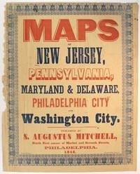
184660347Philadelphia: Evans printer Fourth below Chestnut 1846. Folio broadside approx. 17½" x 13¾" printed in red and blue with wood and metal type and within an ornate typographic border printed in blue. Left-hand margin slightly ragged but not touching the border; the whole slightly toned but on the whole very good. Purchased as a broadside in fact this is likely the upper wrapper of Mitchell's Maps of New Jersey Pennsylvania Maryland & Delaware Philadelphia City and Washington City five color maps issued together in 1846. Whether this colorful setting of type was used as a commercial advertisement beyond the obvious display on the wrapper is uncertain. Phillips List of Geographical Atlases in the Library of Congress 3692. Evans, printer, Fourth below Chestnut unknown
1846WRCAM39939Philadelphia: S. Augustus Mitchell 1846. 46pp. plus large folding map 25 x 34 1/4 inches with full period color. 16mo. Original blindstamped and gilt blue morocco with original clasp. Morocco a bit rubbed and edgeworn. Map with two closed tears in left edge where bound in with no loss; small closed tear along Iowa-Missouri border with no loss. The text is very clean. In very good condition the map with brilliant contemporary color. Second edition after the first of 1843 of this rare pocket map of North America showing the United States west to Texas Indian Territory and Dakota Territory i.e. 19° longitude west of Washington D.C. The map J.H. Young's "Mitchell's National Map of the American Republic or the United States of North America" is revised and updated from the 1843 version most notably by the addition of the newly created Territory of Iowa. The inset map of Texas is new to this 1846 edition and dates from the first year of statehood still showing Texas with its Republic boundaries. The Oregon inset is also new and shows the Oregon border going north into Canada i.e. before the 1846 treaty boundaries. There are also two population tables and the text lists the major railroad steamboat and stage routes all the way west to Iowa Wisconsin and Missouri. The four insets are: "Map of the North-Eastern boundary of the United States According to the Treaty of 1842" "Map of the Southern part of Florida" "Map of Oregon Territory" and "Map of the State of Texas." These four insets take the place of the thirty-two small inset maps of cities and town from the 1843 version of the map. Rumsey lists only the wall map version of this 1846 map. OCLC locates eight copies of this important pocket map. RISTOW p.310. OCLC 228693421 8551053. RUMSEY 3796 ref. S. Augustus Mitchell unknown books
184631381Philadelphia: S. Augustus Mitchell 1846. 16mo. 46pp. plus large folding map 25 x 34 1/4 inches with full period color. Original blindstamped and gilt purple morocco with original clasp. Morocco a bit rubbed and edgeworn. One significant tear from the left edge where bound in with no loss; several other noticeable separations along folds.<br/> <br/>Second edition after the first of 1843 of this rare pocket map of North America showing the United States west to Texas Indian Territory and Dakota Territory i.e. 19° longitude west of Washington D.C.<br/> <br/>The map J.H. Young's "Mitchell's National Map of the American Republic or the United States of North America" is revised and updated from the 1843 version most notably by the addition of the newly created Territory of Iowa. The inset map of Texas is new to this 1846 edition and dates from the first year of statehood still showing Texas with its Republic boundaries. The Oregon inset is also new and shows the Oregon border going north into Canada i.e. before the 1846 treaty boundaries. There are also two population tables and the text lists the major railroad steamboat and stage routes all the way west to Iowa Wisconsin and Missouri. The four insets are: "Map of the North-Eastern boundary of the United States According to the Treaty of 1842" "Map of the Southern part of Florida" "Map of Oregon Territory" and "Map of the State of Texas." These four insets take the place of the thirty-two small inset maps of cities and town from the 1843 version of the map. Rumsey lists only the wall map version of this 1846 map. OCLC locates eight copies of this important pocket map.<br/> <br/>OCLC 228693421 8551053; Ristow p.310; Rumsey 3796 ref. S. Augustus Mitchell unknown books
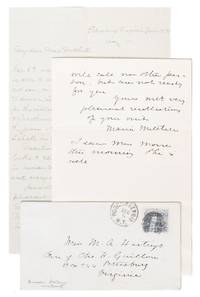
18707830Poughkeepsie NY & Petersburg VA 1870. Near Fine. This exceptional correspondence documents the esteemed astronomer Maria Mitchell 1818 - 1889 supporting the career of Troy Female Seminary science educator Mary Anne Hastings 1822 - 1906. Two ALS and an envelope: Maria Mitchell's letter dated December 6 1869 2 pp. on one sheet measuring 116 x 181 mm folded and her envelope measuring 132 x 73 mm addressed to Hastings and postmarked Poughkeepsie NY; and Mary A. Hastings' letter dated January 10 1870 1 p. measuring 133 x 205 mm. In Near Fine condition. Both letters with old folds and Mitchell's with a patch of toning but clean overall. Mitchell's letters are scarce in commerce and letters with significant content are rare: this correspondence is definitely significant evidencing Mitchell's connections with other women in the sciences and how those connections were essential for women's success in the strictly male-controlled scientific field of the nineteenth century.<br /> <br /> In 1869 Maria Mitchell was in the fifth year of her appointment as Professor of Astronomy and Directory of the Observatory at Vassar College in Poughkeepsie New York. She had already been an influential astronomer for over two decades: she discovered the comet C/1847 T1 "Miss Mitchell's Comet" in 1847; was "the only American woman to gain self-supporting scientific employment and international recognition" throughout the 1850s ANB; and had recently been elected to the American Philosophical Society only the third woman and the first American woman to gain membership. <br /> <br /> These two letters between Mitchell and Mary A. Hastings capture an instance of Mitchell advocating professionally for another prominent science educator. The letters refer to a meeting at Vassar between the two educators in which they discussed Hastings' potential employment at Swarthmore College: Hastings writes "Thank you very heartily for the interest you have taken in my going to Swarthmore" and "I am glad I met you for those pleasant hours in Vassar - I dare hardly tell you how precious they were to me." In her own letter Mitchell notes that she discussed Hastings in correspondence with Swarthmore President Edward Parrish 1822 - 1872: Mitchell forwards Parrish's response "Thy mention of Miss H. is noted. We still keep her in view" and explains "So it is as I supposed. They will call no other person but are not ready for you." Mitchell concludes her letter with well wishes for Hastings and a mention of her colleague Ann Eliza Morse "I saw Miss Morse this morning. She is well" the longtime assistant to Vassar's Lady Principal Hannah W. Lyman. <br /> <br /> Throughout her career Mitchell was dedicated to cultivating solidarity between professional women; an incident during her tenure at Vassar demonstrates how crucial that solidarity could be. Though Mitchell had already well earned her esteem as an astronomer and educator by the time she began working at the college she and her fellow educator Dr. Alida Avery realized that they were both being paid less than half the salary of their male counterparts Mitchell herself was being paid less than a third. Beginning in 1870 Mitchell and Dr. Avery became embroiled in a years-long battle with the administration eventually being granted a significant salary increase that still capped their pay below that of male professors. Mitchell later went on to help organize the Association for the Advancement of Women a precursor to the General Federation of Women's Clubs and was an ardent advocate for the acceptance of women in the sciences in particular; her "advocacy and influence" can be partially credited with bringing many women into the field as astronomical computers in the late nineteenth century ANB. <br /> <br /> By the time Hastings and Mitchell had their meeting at Vassar Hastings had been an educator for over twenty years primarily in mathematics and the sciences. The same year that Mitchell observed her comet Hastings had gained a teaching appointment at the Troy Female Seminary her alma mater where she "became one of the first women in America to offer laboratory lectures with experiments" University of Michigan. She later served as principal of the Female Seminary in Hamilton New York and held a teaching position at Ripley Female College in Vermont. At the time she wrote this letter she had left New England for Virginia then in the midst of Reconstruction; she observes in a nod to Mitchell's own abolitionist convictions: "I am learning how the world looks to educated people who have no belief in human rights or faith in human progress and every day I think God for New England." Though Hastings seemingly never found employment at Swarthmore she did return to New England to teach mathematics to the inaugural class of fifteen students at Smith College in 1875. <br /> <br /> Full transcripts of the letters are available upon request.<br /> <br /> "Maria Mitchell Determined Stargazer." American Philosophical Society September 13 2018. University of Michigan. "Finding Aid: Ruth Hastings papers 1852-1853."<br /> General Catalogue of the Officers and Graduates of Vassar College 1881. Vassar Encyclopedia "Maria Mitchell Salary Dispute." Near Fine. unknown