46 résultats
17795597London: Published by J.F.W. Des Barres in 'The Atlantic Neptune' 1779. Sea chart etched with roulette-work with original colour with aquatint view. Printed on laid paper with 'J Bates' watermark and 'JB' countermark. A very fine sea chart and view of Egmont now called Jeddore Harbour from 'The Atlantic Neptune' the first British sea atlas of her North American colonies<br/> <br/>This is a finely presented and highly detailed chart of what is now known as Jeddore Harbour near Halifax. The bay seven miles long and three miles wide is captured in a cartographic composition of great topographical and hydrographical detail and is further embellished by a roundel containing a mariner's view of the area. This chart is the fifth and final state produced and is identical to the Henry Stevens Collection variant 49G in the National Maritime Museum Greenwich. Des Barres studied under the great mathematician Daniel Bernoulli at the University of Basel before continuing on to the Royal Military College at Woolwich. On the outbreak of the Seven Years war in 1756 he joined the British Royal American Regiment as a military engineer. He came to the attention of General James Wolfe who appointed him to be his aide-de-camp. From 1762 Des Barres was enlisted to survey the coastlines of Nova Scotia Newfoundland and the Gulf of St.Lawrence while his colleague Samuel Holland charted the New England coast. In 1774 Des Barres returned to England where he began work on the Neptune. His dedication to the project was so strong that often at his own expense he continually updated and added new charts and views up until 1784. That year he returned to Canada where he remained for a further forty years becoming a senior political figure and a wealthy land owner and living to the advanced age of 103. The Atlantic Neptune was the first British sea atlas of her North American colonies and one of the most important achievements of eighteenth century cartography. With an official commission from the Royal Navy Des Barres published the first volume in London in 1775 which was soon followed by further volumes. Des Barres' monumental endeavor eventually featured over two-hundred charts and aquatint views many being found in several states. All of the charts were immensely detailed featuring both hydrographical and topographical information. Des Barres' plates were used to print further editions up into the first decade of the nineteenth-century. The Neptune met with the highest acclaim from the beginning and is today widely regarded as superior to all other atlases produced during its time.<br/> <br/>National Maritime Museum: Henry Stevens Collection: K0124 HNS 49G & Catalogue no.38 p.382; Cf. Spendlove The Face of Early Canada Chapter 4: "J.F.W. Des Barres and The Atlantic Neptune"; pp. 18-22; Debard "The Family Origins of Joseph Frederick Wallet Des Barres: A Riddle Finally Solved" Nova Scotia Historical Review Vol 14 No. 2 1994 p.15. Published by J.F.W. Des Barres in 'The Atlantic Neptune' unknown books
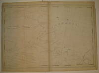
177928787London: British Admiralty for 'The Atlantic Neptune' 1779. Etching with roulette work original outline color on laid paper watermarked "JBates" and countermarked "JB" This excellent example of Des Barres' craftsmanship details a portion of the strait between New Brunswick and what is now Prince Edward Island then St. John's Island. It includes on the New Brunswick side: Shediac Cocagne and Boutouche. The chart includes soundings throughout the Straits and Baie Verte. This is one of the many regions Des Barres himself surveyed during the 1760s. Des Barres of Swiss-Huguenot extraction studied under the great mathematician Daniel Bernoulli at the University of Basel before continuing on to the Royal Military College at Woolwich. Upon the outbreak of hostilities with France in 1756 he joined the British Royal American Regiment as a military engineer. He came to the attention of General James Wolfe who appointed him to join his personal detail. During this period he also worked with the future legendary explorer James Cook on a monumental chart of the St. Lawrence River. From 1762 Des Barres was enlisted to survey the coastlines of Nova Scotia Newfoundland and the Gulf of St. Lawrence while his colleague Samuel Holland charted the New England coast. He also managed to gain access to some surveys of the American South Cuba and Jamaica. In 1774 Des Barres returned to England where he began work on The Neptune. His dedication to the project was so strong that often at his own expense he continually updated and added new charts and views up until 1784. That year he returned to Canada where he remained for a further forty years becoming a senior political figure and a wealthy land owner and living to the advanced age of 103. The Atlantic Neptune the most celebrated sea atlas contained the first systematic survey of the east coast of North America. Des Barres's synergy of great empirical accuracy with the peerless artistic virtue of his aquatint views created a work that "has been described as the most splendid collection of charts plates and views ever published" National Maritime Museum Catalogue. Upon the conclusion of the Seven Years War Britain's empire in North America was greatly expanded and this required the creation of a master atlas featuring new and accurate sea charts for use by the Royal Navy. Des Barres was charged with this Herculean task publishing the first volume in London in 1775 which was soon followed by three further volumes. Des Barres's monumental endeavor eventually featured over two-hundred charts and views many being found in several states. Des Barres's charts were immensely detailed featuring both hydrographical and topographical information and in many cases remained the most authoritative maps of the regions covered for several decades.<br/> <br/>Streeter copy: Vol. II # 58; Stevens 68e. British Admiralty for 'The Atlantic Neptune'] unknown books
178134269London: Published by J.F.W. Des Barres in 'The Atlantic Neptune' 1781. Etching with aquatint. Sheet size: 33 x 24 1/4 inches. A portion of the upper left platemark expertly reinforced. 3rd state of 5 Corresponding to Stevens 51 c. A set of six navigational views of Halifax Harbour and nearby coastal area from one of the most important North American marine atlases.<br/> <br/>This group includes four views intended as aids to navigation. The profiles were intended for use by captains of vessels to identify exactly where they were in relation to distant shorelines; added to these is a charming roundel giving a picturesque view of a waterfall on the Hinchinbroke River and finally a tranquil view in Halifax harbour which is enlivened by the small scene in the lower right of the image where amid clouds of steam men work frantically to re-tar the hull of a man-of-war. This later state of the print incorporates all the improvements in detail and the addition of sailing ships of all kinds. 'The Atlantic Neptune' was the first great marine atlas and one of the greatest achievements of eighteenth century cartography. Published in England in 1774 it contained over 250 charts and views of the North American and Canadian coasts. The charts were intensely detailed and contained both hydrographical and topographical details. The Neptune was compiled and published for the Royal Navy by Joseph F. W. Des Barres a Swiss cartographer who joined the Royal American Regiment as a surveyor. Des Barres fought in the French and Indian wars and was enlisted to survey the Canadian coastline. While his fellow surveyor Samuel Holland charted the New England coast Des Barres mapped the shoreline of Nova Scotia Newfoundland and the St. Lawrence River regions. In 1774 Des Barres returned to England where he compiled and published his monumental atlas; his dedication to the project was so strong that he published an updated version of the work every year until 1784. Des Barres' work was so superior to any other contemporary atlas that the maps were used as the standard charts of the East coast for over 50 years. The Neptune remains one of the most important atlases ever printed its views and maps chart the history of North America and allow us to glimpse forgotten shores long changed with the passage of time.<br/> <br/>Spendlove The Face of Early Canada Chapter 4: "J.F.W. Des Barres and The Atlantic Neptune"; pp. 18-22; Debard "The Family Origins of Joseph Fredericks Wallet DesBarres: A Riddle Finally Solved" Nova Scotia Historical Review Vol 14 No. 2 1994 p.15; Catalogue of the Henry Newton Stevens Collection.51c. Published by J.F.W. Des Barres in 'The Atlantic Neptune' unknown books
17815598London: Published by J.F.W. Des Barres in 'The Atlantic Neptune' 1781. Etching with added hand-colour. On laid paper with 'J Bates' watermark and 'JB' countermark. A fine print from "The Atlantic Neptune" which charts the Annapolis Royal with a coastal view of Gulliver's Hole and a descriptive text.<br/> <br/>'The Atlantic Neptune' was the first great marine atlas and one of the greatest achievements of eighteenth century cartography. Published in England in 1774 it contained over 250 charts and views of the North American and Canadian coasts. The charts were intensely detailed and contained both hydrographical and topographical details. The Neptune was compiled and published for the Royal Navy by Joseph F. W. Des Barres a Swiss cartographer who joined the Royal American Regiment as a surveyor. Des Barres fought in the French and Indian wars and was enlisted to survey the Canadian coastline. While his fellow surveyor Samuel Holland charted the New England coast Des Barres mapped the shoreline of Nova Scotia Newfoundland and the St. Lawrence River regions. In 1774 Des Barres returned to England where he compiled and published his monumental atlas; his dedication to the project was so strong that he published an updated version of the work every year until 1784. Des Barres' work was so superior to any other contemporary atlas that the maps were used as the standard charts of the East coast for over 50 years. The Neptune remains one of the most important atlases ever printed its views and maps chart the history of North America and allow us to glimpse a forgotten land long changed by the passage of time. This chart is an excellent eighteenth century record of the first settlement in Canada. In 1605 two years before the first permanent English settlement at Jamestown three years before the founding of Quebec and fifteen years before the Pilgrims landed at Plymouth a small party of French explorers led by Sieur de Monts established Port Royal as the first settlement in Canada. The settlement was later renamed Annapolis Royal which is the name asigned to it in Des Barres chart.<br/> <br/>Spendlove The Face of Early Canada Chapter 4: "J.F.W. Des Barres and The Atlantic Neptune"; pp. 18-22; Debard "The Family Origins of Joseph Fredericks Wallet DesBarres: A Riddle Finally Solved" Nova Scotia Historical Review Vol 14 No. 2 1994 p.15. Published by J.F.W. Des Barres in 'The Atlantic Neptune' unknown books
17813608London: Published by J.F.W Des Barres in 'The Atlantic Neptune' 1781. Etching with aquatint printed in sepia. Printed on laid paper with watermark `J Bates' and countermark `JB'. A large-scale view of the scenery near Lakevale and Antigonish on the North West coast of Nova Scotia from 'The Atlantic Neptune' the first British sea atlas of her North American colonies<br/> <br/>This is a very fine scene depicting a dramatic point where the highlands of Nova Scotia cascade into the Gulf of St. Lawrence. This is the second state of this view and is identical to the Henry Stevens Collection variant 70B in the National Maritime Museum Greenwich. Des Barres studied under the great mathematician Daniel Bernoulli at the University of Basel before continuing on to the Royal Military College at Woolwich. On the outbreak of the Seven Years war in 1756 he joined the British Royal American Regiment as a military engineer. He came the attention of General James Wolfe who appointed him to be his aide-de-camp. From 1762 Des Barres was enlisted to survey the coastlines of Nova Scotia Newfoundland and the Gulf of St.Lawrence while his colleague Samuel Holland charted the New England coast. In 1774 Des Barres returned to England where he began work on the Neptune. His dedication to the project was so strong that often at his own expense he continually updated and added new charts and views up until 1784. That year he returned to Canada where he remained for a further forty years becoming a senior political figure and a wealthy land owner and living to the advanced age of 103. The Atlantic Neptune was the first British sea atlas of her North American colonies and one of the most important achievements of eighteenth century cartography. With an official commission from the Royal Navy Des Barres published the first volume in London in 1775 which was soon followed by further volumes. Des Barres' monumental endeavor eventually featured over two-hundred charts and aquatint views many being found in several states. All of the charts were immensely detailed featuring both hydrographical and topographical information. Des Barres' plates were used to print further editions up into the first decade of the nineteenth-century. The Neptune met with the highest acclaim from the beginning and is today widely regarded as superior to all other atlases produced during its time.<br/> <br/>Spendlove The Face of Early Canada Chapter 4: "J.F.W. Des Barres and The Atlantic Neptune"; pp. 18-22; Debard "The Family Origins of Joseph Fredericks Wallet DesBarres: A Riddle Finally Solved" Nova Scotia Historical Review Vol 14 No. 2 1994 p.15; National Maritime Museum: Henry Stevens Collection: K0231 HNS 70B. Published by J.F.W Des Barres in 'The Atlantic Neptune' unknown books
178013223London: Published by J.F.W. Des Barres in 'The Atlantic Neptune' 1780. Etching with aquatint printed in sepia. On laid paper with 'J Bates' watermark and 'JB' countermark. Expertly repaired 1/2 inch hole to image. A very fine view of Quebec. This image is one of the most important of all the views included in Des Barres masterpiece: 'The Atlantic Neptune'.<br/> <br/>'The Atlantic Neptune' was the first great marine atlas and one of the greatest achievements of eighteenth century cartography. Published in England in 1774 it contained over 250 charts and views of the North American and Canadian coasts. The charts were intensely detailed and contained both hydrographical and topographical details. The Neptune was compiled and published for the Royal Navy by Joseph F. W. Des Barres a Swiss cartographer who joined the Royal American Regiment as a surveyor. Des Barres fought in the French and Indian wars and was enlisted to survey the Canadian coastline. While his fellow surveyor Samuel Holland charted the New England coast Des Barres mapped the shoreline of Nova Scotia Newfoundland and the St. Lawrence River regions. In 1774 Des Barres returned to England where he compiled and published his monumental atlas; his dedication to the project was so strong that he published an updated version of the work every year until 1784. Des Barres' work was so superior to any other contemporary atlas that the maps were used as the standard charts of the East coast for over 50 years. The Neptune remains one of the most important atlases ever printed its views and maps chart the history of Canada and the United states and allow us to glimpse a forgotten land long changed by the passage of time. Spendlove writes that the 'large prints from The Atlantic Neptune are among the finest and most beautiful pictures of Canada ever made. Des Barres was an artist of great ability. and his delineation of ships was particularly effective and one could hardly find anything finer' The Face of Early Canada pp. 18-19. The present view is apparently taken from on board a ship on the St. Lawrence River looking north west towards towards the citadel and burgeoning city of Quebec. In the foreground are two finely-observed merchantmen their flags and pennants streaming out in the stiff breeze blowing up the river valley. This is an historically important image of Quebec as it looked twenty years after its capture by Wolfe drawn by an artist of high merit who took part in the 1759 campaign. Second state of 2<br/> <br/>National Maritime Museum Greenwich Henry Newton Stevens Collection 125a; Cf. Spendlove The Face of Early Canada Chapter 4: "J.F.W. Des Barres and The Atlantic Neptune"; pp. 18-22; Debard "The Family Origins of Joseph Fredericks Wallet DesBarres: A Riddle Finally Solved" Nova Scotia Historical Review Vol 14 No. 2 1994 p.15; Stevens 125B. Published by J.F.W. Des Barres in 'The Atlantic Neptune' unknown books
178119326London 1781. Engraved chart the town and border hand-coloured as issued. Minor repaired edge tears. Sheet Size: 22 5/8 x 32 1/2 inches. An important 18th century chart of Louisbourg harbour.<br/> <br/>Des Barres of Swiss-Huguenot extraction studied under the great mathematician Daniel Bernoulli at the University of Basel before continuing on to the Royal Military College at Woolwich. Upon the outbreak of hostilities with France in 1756 he joined the British Royal American Regiment as a military engineer. He came to the attention of General James Wolfe who appointed him to join his personal detail. During this period he also worked with the future legendary explorer James Cook on a monumental chart of the St. Lawrence River. From 1762 Des Barres was enlisted to survey the coastlines of Nova Scotia Newfoundland and the Gulf of St. Lawrence while his colleague Samuel Holland charted the New England coast. He also managed to gain access to some surveys of the American South Cuba and Jamaica. In 1774 Des Barres returned to England where he began work on The Neptune. His dedication to the project was so strong that often at his own expense he continually updated and added new charts and views up until 1784. That year he returned to Canada where he remained for a further forty years becoming a senior political figure and a wealthy land owner and living to the advanced age of 103. The Atlantic Neptune the most celebrated sea atlas contained the first systematic survey of the east coast of North America. Des Barres's synergy of great empirical accuracy with the peerless artistic virtue of his aquatint views created a work that "has been described as the most splendid collection of charts plates and views ever published" National Maritime Museum Catalogue. Upon the conclusion of the Seven Years War Britain's empire in North America was greatly expanded and this required the creation of a master atlas featuring new and accurate sea charts for use by the Royal Navy. Des Barres was charged with this Herculean task publishing the first volume in London in 1775 which was soon followed by three further volumes. Des Barres's monumental endeavor eventually featured over two-hundred charts and views many being found in several states. Des Barres's charts were immensely detailed featuring both hydrographical and topographical information and in many cases remained the most authoritative maps of the regions covered for several decades.<br/> <br/>Stevens 140. unknown books
177734270London: Published by J.F.W. Des Barres in 'The Atlantic Neptune' 1777. Hand-colored etching on Bates paper. No imprint. Sheet size: 32 1/4 x 23 3/4 inches with center fold as with all early issues. Expert restoration to center fold and marginal tears. A set of six navigational views of Halifax Harbour and nearby coastal area from one of the most important North American marine atlases.<br/> <br/>This group includes four profile views intended as aids to navigation. The profiles were intended for use by captains of vessels to identify exactly where they were in relation to distant shorelines; added to these is a charming roundel giving a picturesque view of a waterfall on the Hinchinbroke River and finally a tranquil view in Halifax harbour which is enlivened by the small scene in the lower right of the image where amid clouds of steam men work frantically to re-tar the hull of a man-of-war. This finely coloured example of the print corresponds to Stevens 51 first state without stamped plate number. 'The Atlantic Neptune' was the first great marine atlas and one of the greatest achievements of eighteenth century cartography. Published in England in 1774 it contained over 250 charts and views of the North American and Canadian coasts. The charts were intensely detailed and contained both hydrographical and topographical details. The Neptune was compiled and published for the Royal Navy by Joseph F. W. Des Barres a Swiss cartographer who joined the Royal American Regiment as a surveyor. Des Barres fought in the French and Indian wars and was enlisted to survey the Canadian coastline. While his fellow surveyor Samuel Holland charted the New England coast Des Barres mapped the shoreline of Nova Scotia Newfoundland and the St. Lawrence River regions. In 1774 Des Barres returned to England where he compiled and published his monumental atlas; his dedication to the project was so strong that he published an updated version of the work every year until 1784. Des Barres' work was so superior to any other contemporary atlas that the maps were used as the standard charts of the East coast for over 50 years. The Neptune remains one of the most important atlases ever printed its views and maps chart the history of North America and allow us to glimpse forgotten shores long changed with the passage of time.<br/> <br/>Spendlove The Face of Early Canada Chapter 4: "J.F.W. Des Barres and The Atlantic Neptune"; pp. 18-22; Debard "The Family Origins of Joseph Fredericks Wallet DesBarres: A Riddle Finally Solved" Nova Scotia Historical Review Vol 14 No. 2 1994 p.15; Stevens 51A. Published by J.F.W. Des Barres in 'The Atlantic Neptune' unknown books
178133877London: Published by J.F.W. Des Barres in 'The Atlantic Neptune' 1781. Etching with aquatint. Printed on laid paper with `J. Bates' watermark and `JB' countermark. Skillful marginal restoration in several places. One of the most desirable large-scale views from the 'The Atlantic Neptune' the first British sea atlas of her North American colonies.<br/> <br/>In this fine scene Des Barres depicts his own men camping beneath the hills that form the spine of Sable Island the 20 mile-long shifting sandbar that lies 111 miles off the coast of Halifax. From 1766 to 1768 Des Barres and his party spent two seasons surveying the waters around Sable Island. The island is known for both for its wild horses depicted here and more ominously. as the "Graveyard of the Atlantic." The island is the last offshore remnant from the time when the sea levels were much lower. It is theorized that the vast mound of sand that forms the island was deposited there by glaciers at the end of the last ice age. The shifting nature of the shoals off the island allied with treacherous sea currents have meant that until the invention of modern navigational techniques it was extremely hazardous to ships. Over 350 wrecks have been recorded since 1583 the most recent in July 1999. The horses on the island now numbering about 200 are probably descended from stock belonging to the Acadians of Nova Scotia. In 1760 the Boston merchant Thomas Hancock shipped 60 Acadian horses to Sable island where they have bred and flourished ever since. The isolated nature of the herd means that they provide insights into the type of animal that was favoured by the eighteenth-century settlers. This view is the fourth and final state produced and is identical to the Henry Stevens Collection variant 77D in the National Maritime Museum Greenwich. Des Barres studied under the great mathematician Daniel Bernoulli at the University of Basel before continuing on to the Royal Military College at Woolwich. On the outbreak of the Seven Years war in 1756 he joined the British Royal American Regiment as a military engineer. He came the attention of General James Wolfe who appointed him to be his aide-de-camp. From 1762 Des Barres was enlisted to survey the coastlines of Nova Scotia Newfoundland and the Gulf of St.Lawrence while his colleague Samuel Holland charted the New England coast. In 1774 Des Barres returned to England where he began work on the Neptune. His dedication to the project was so strong that often at his own expense he continually updated and added new charts and views up until 1784. That year he returned to Canada where he remained for a further forty years becoming a senior political figure and a wealthy land owner and living to the advanced age of 103. The Atlantic Neptune was the first British sea atlas of her North American colonies and one of the most important achievements of eighteenth century cartography. With an official commission from the Royal Navy Des Barres published the first volume in London in 1775 which was soon followed by further volumes. Des Barres' monumental endeavor eventually featured over two-hundred charts and aquatint views many being found in several states. All of the charts were immensely detailed featuring both hydrographical and topographical information. Des Barres' plates were used to print further editions up into the first decade of the nineteenth-century. The Neptune met with the highest acclaim from the beginning and is today widely regarded as superior to all other atlases produced during its time.<br/> <br/>Spendlove The Face of Early Canada Chapter 4: "J.F.W. Des Barres and The Atlantic Neptune"; pp. 18-22; Debard "The Family Origins of Joseph Fredericks Wallet DesBarres: A Riddle Finally Solved" Nova Scotia Historical Review Vol 14 No. 2 1994 p.15; National Maritime Museum: Henry Stevens Collection: K0252 HNS 77D &Catalogue no.62-66 p.383; Phillips p.634. Published by J.F.W. Des Barres in 'The Atlantic Neptune' unknown books
1776227653London 1776. First. unbound. very good. Sea chart. Engraving. Image measures 27.25" x 40.25".<br/><br/> Beautiful rare nautical chart of Port Campbell SE Nova Scotia. This is the first state and shows settlements and shoals in outline only. Includes the yet named Shelburne Harbour and Roseneath Island now McNutt Island. Includes description of the shoreline and tides. Map is dated 1776 just before the Loyalists came and settled the area. Published in "The Atlantic Neptune" the first British sea atlas of the eastern coast of North America hailed for both its accuracy and its aesthetics. J.F.W. Des Barres c. 1729-1827 was born in Basle Switzerland but went to military school in England. He became a colonial administrator in Nova Scotia and also served as governor of Quebec. Des Barres was commissioned for the surveying project in 1762 and dedicated ten years to the gathering of the charts and publication of the atlas. Small chips and tears to margin not affecting the image slight wear to original folds overall toning.<br/><br/> unknown books
177913202London: Published by J.F.W. Des Barres in 'The Atlantic Neptune' 1779. Etching with aquatint printed in sepia coloured by hand. Printed on laid paper with `J Bates' watermark and `JB' countermark. Small tears to fold repaired tear to plate mark. A large-scale view of the entrance to the harbour at Louisbourg from one of the most important North American marine atlases.<br/> <br/>This very fine view is taken from the sea with the harbour mouth in the foreground and in the background the spires and roofs of the town and fort of Louisbourg the port of entry to Cape Breton county Nova Scotia. As usual Des Barres has added rowing boats and ships to give the viewer the correct sense of scale. Des Barres of Swiss-Huguenot extraction studied under the great mathematician Daniel Bernoulli at the University of Basel before continuing on to the Royal Military College at Woolwich. Upon the outbreak of hostilities with France in 1756 he joined the British Royal American Regiment as a military engineer. He came to the attention of General James Wolfe who appointed him to join his personal detail. During this period he also worked with the future legendary explorer James Cook on a monumental chart of the St. Lawrence River. From 1762 Des Barres was enlisted to survey the coastlines of Nova Scotia Newfoundland and the Gulf of St. Lawrence while his colleague Samuel Holland charted the New England coast. He also managed to gain access to some surveys of the American South Cuba and Jamaica. In 1774 Des Barres returned to England where he began work on The Neptune. His dedication to the project was so strong that often at his own expense he continually updated and added new charts and views up until 1784. That year he returned to Canada where he remained for a further forty years becoming a senior political figure and a wealthy land owner and living to the advanced age of 103. The Atlantic Neptune the most celebrated sea atlas contained the first systematic survey of the east coast of North America. Des Barres's synergy of great empirical accuracy with the peerless artistic virtue of his aquatint views created a work that "has been described as the most splendid collection of charts plates and views ever published" National Maritime Museum Catalogue. Upon the conclusion of the Seven Years War Britain's empire in North America was greatly expanded and this required the creation of a master atlas featuring new and accurate sea charts for use by the Royal Navy. Des Barres was charged with this Herculean task publishing the first volume in London in 1775 which was soon followed by three further volumes. Des Barres's monumental endeavor eventually featured over two-hundred charts and views many being found in several states. Des Barres's charts were immensely detailed featuring both hydrographical and topographical information and in many cases remained the most authoritative maps of the regions covered for several decades.<br/> <br/>Spendlove The Face of Early Canada Chapter 4: "J.F.W. Des Barres and The Atlantic Neptune"; pp. 18-22; National Maritime Museum Greenwich Henry Newton Stevens Collection: 65C; Debard "The Family Origins of Joseph Fredericks Wallet DesBarres: A Riddle Finally Solved" Nova Scotia Historical Review Vol 14 No. 2 1994 p.15. Published by J.F.W. Des Barres in 'The Atlantic Neptune' unknown books
17793603London: Published by J.F.W. Des Barres in 'The Atlantic Neptune' 1779. Etching with aquatint printed in sepia. Printed on laid paper with `J Bates' watermark and `JB' countermark. A large-scale view of the entrance to the harbour at Louisbourg from 'The Atlantic Neptune' the first British sea atlas of her North American colonies<br/> <br/>A fine view of the harbour of Louisbourg the former "impregnable" fortress that was the gateway to French America and the scene of two great battles between France and Britain in 1748 and 1758. The scene depicted here features ships sailing into the excellent natural harbour surrounded by a ruggedly beautiful landscape. This is the third state of this view and is identical to the Henry Stevens Collection variant 65C in the National Maritime Museum Greenwich. Des Barres studied under the great mathematician Daniel Bernoulli at the University of Basel before continuing on to the Royal Military College at Woolwich. On the outbreak of the Seven Years war in 1756 he joined the British Royal American Regiment as a military engineer. He came the attention of General James Wolfe who appointed him to be his aide-de-camp. From 1762 Des Barres was enlisted to survey the coastlines of Nova Scotia Newfoundland and the Gulf of St.Lawrence while his colleague Samuel Holland charted the New England coast. In 1774 Des Barres returned to England where he began work on the Neptune. His dedication to the project was so strong that often at his own expense he continually updated and added new charts and views up until 1784. That year he returned to Canada where he remained for a further forty years becoming a senior political figure and a wealthy land owner and living to the advanced age of 103. The Atlantic Neptune was the first British sea atlas of her North American colonies and one of the most important achievements of eighteenth century cartography. With an official commission from the Royal Navy Des Barres published the first volume in London in 1775 which was soon followed by further volumes. Des Barres' monumental endeavor eventually featured over two-hundred charts and aquatint views many being found in several states. All of the charts were immensely detailed featuring both hydrographical and topographical information. Des Barres' plates were used to print further editions up into the first decade of the nineteenth-century. The Neptune met with the highest acclaim from the beginning and is today widely regarded as superior to all other atlases produced during its time.<br/> <br/>Spendlove The Face of Early Canada Chapter 4: "J.F.W. Des Barres and The Atlantic Neptune"; pp. 18-22; Debard "The Family Origins of Joseph Fredericks Wallet Des Barres: A Riddle Finally Solved" Nova Scotia Historical Review Vol 14 No. 2 1994 p.15; National Maritime Museum: Henry Stevens Collection: K0206 HNS 65C. Published by J.F.W. Des Barres in 'The Atlantic Neptune' unknown books
178134403London: J.F.W. Des Barres 1781. Hand-colored line engraving and aquatint. Two plates printed on two sheets joined with 8 views arranged in 5 rows. Sheet size: 32 x 43 3/4 inches. 8 navigational profile views from the greatest of all 18th century sea atlases.<br/> <br/>These eight views of sites in and around Nova Scotia were designed to give navigators additional information to the soundings on the charts of these same places. Several of the placenames have changed but Beaver Island Port Bickerton Chedabucto Bay and Canso remain. This is the 5th of 5 states with many ships and aquatinted features to the landscapes added to the original plates. Des Barres of Swiss-Huguenot extraction studied under the great mathematician Daniel Bernoulli at the University of Basel before continuing on to the Royal Military College at Woolwich. Upon the outbreak of hostilities with France in 1756 he joined the British Royal American Regiment as a military engineer. He came to the attention of General James Wolfe who appointed him to join his personal detail. During this period he also worked with the future legendary explorer James Cook on a monumental chart of the St. Lawrence River. From 1762 Des Barres was enlisted to survey the coastlines of Nova Scotia Newfoundland and the Gulf of St. Lawrence while his colleague Samuel Holland charted the New England coast. He also managed to gain access to some surveys of the American South Cuba and Jamaica. In 1774 Des Barres returned to England where he began work on The Neptune. His dedication to the project was so strong that often at his own expense he continually updated and added new charts and views up until 1784. That year he returned to Canada where he remained for a further forty years becoming a senior political figure and a wealthy land owner and living to the advanced age of 103.<br/> <br/>The American Revolution in drawings and prints; a checklist of 1765-1790 graphics in the Library of Congress / Compiled by Donald H. Cresswell with a foreword by Sinclair H. Hitchings. Washington : 1975 no. 397-404; #61e Henry Stevens Collection. J.F.W. Des Barres unknown books
177920759London: Published by J. F. W. Des Barres in 'The Atlantic Neptune' 1779. Black and white copper engraving. Large repaired tear 12" from bottom edge parallel to centerfold. 4" repaired split from bottom in centerfold. Thin uneven margins. Plate size: 30 1/4 x 22 1/8 inches. This is a fantastic sea chart of the Delaware coast from the 'The Atlantic Neptune' which is universally recognized as one of the most magnificent atlases ever made.<br/> <br/>This superb sea chart constructed for the use of the British Navy shows the major part of the Delaware coast from Rehobeth to Bombay Hook as well as the opposing south New Jersey shore. 'The Atlantic Neptune' was the first great marine atlas and one of the great achievements of eighteenth century cartography. When publication in England began in 1774 it contained over 250 charts and views of the North American and Canadian coasts. The charts were intensely detailed and contained both hydrographical and topographical details. The Neptune was compiled and published for the Royal Navy by Joseph F. W. Des Barres a Swiss cartographer who joined the Royal American Regiment as a surveyor. Des Barres fought in the French and Indian wars and was enlisted to survey the Canadian coastline. While his fellow surveyor Samuel Holland charted the New England coast Des Barres mapped the shoreline of Nova Scotia Newfoundland and the St. Lawrence River regions. In 1774 Des Barres returned to England where he compiled and published his monumental atlas; his dedication to the project was so strong that he published an updated version of the work every year until 1784. Des Barres' work was so superior to any other contemporary atlas that the maps were used as the standard charts of the East coast for over 50 years. The Neptune remains one of the most important atlases ever printed its views and maps chart as aspect of the history of North America and now allow us to glimpse this land drastically changed by the passage of time.<br/> <br/>Snyder City of Independence p. 271; Stevens 158. Published by J. F. W. Des Barres in 'The Atlantic Neptune' unknown books
177634405London: J. F. W. Des Barres 1776. Engraved with color wash and outline color. Sheet: 31 x 42 1/4 inches. Expert restoration primarily at the upper margin. Two sheets joined both watermarked "J.Bates" and countermarked "JB". Fourth state of five. Among the earliest charts published by Des Barres were those relevant to the crisis in New England as the War of Independence broke out.<br/> <br/>This chart depicts the coast of Massachusetts from Salem to Scituate Harbor and includes the complicated hydrography of Boston Harbor and the confluent rivers. A considerable amount of coastal topography is included obviously relevant to warships. Fundamentally a chart for navigators it includes soundings and shoals with particularly strong detail along the Charles and Mystic Rivers as well as in Salem and Marblehead. Samuel Holland was the lead surveyor. In 1764 he was named Surveyor General of both the Province of Quebec and the Northern District of North America. He had a considerable staff and the British Navy assisted in providing soundings. From 1770 to 1774 his squad worked exclusively on northeastern colonies that soon became part of the United States. The surveys that derived from the industry of their work were the most accurate ever made to that time. They were sent to London where Des Barres supervised the engraving and publication. The charts were very soon put to use. Des Barres of Swiss-Huguenot extraction studied under the great mathematician Daniel Bernoulli at the University of Basel before continuing on to the Royal Military College at Woolwich. Upon the outbreak of hostilities with France in 1756 he joined the British Royal American Regiment as a military engineer. He came to the attention of General James Wolfe who appointed him to join his personal detail. During this period he also worked with the future legendary explorer James Cook on a monumental chart of the St. Lawrence River. From 1762 Des Barres was enlisted to survey the coastlines of Nova Scotia Newfoundland and the Gulf of St. Lawrence while his colleague Samuel Holland charted the New England coast. He also managed to gain access to some surveys of the American South Cuba and Jamaica. In 1774 Des Barres returned to England where he began work on The Neptune. His dedication to the project was so strong that often at his own expense he continually updated and added new charts and views up until 1784. That year he returned to Canada where he remained for a further forty years becoming a senior political figure and a wealthy land owner and living to the advanced age of 103.<br/> <br/>Stevens Collection 94d ; cf. Hornsby Surveyors of Empire: Samuel Holland J.F.W. Des Barres and the Making of the Atlantic Neptune. 2011. J. F. W. Des Barres unknown books
177517671London: Published by J.F.W. Des Barres in 'The Atlantic Neptune' 1775. Copper-engraved and etched map with aquatint on two joined sheets. Printed on laid paper with `J Bates' watermark and `JB' countermark in excellent condition. Sheet size: 30 1/4 x 42 5/8 inches. With: The explanatory text leaf titled as above. 1p. folio 25 1/2 x 19 inches. The finest and most celebrated sea chart of Boston Harbor ever produced and a highly important Revolutionary War map depicting details relating to the Siege of Boston: with the very rare explanatory text leaf.<br/> <br/>This is one the most important maps contained in Des Barres' The Atlantic Neptune and one of the most significant large-scale maps of the Revolutionary War. It provides an invaluable record of Boston at the beginning of the war covering the area from the environs of the city out into the open waters of Massachusetts Bay. A particularly striking feature is the use of boldly etched and subtly aquatinted details to capture the diverse topography of the region including the numerous hills islands and river estuaries. It is important to remember that this was issued as a working sea-chart and as such the cartographer has naturally concentrated on features such as depth soundings indicated by detailed lines and based on surveys by Samuel Holland and George Callendar and the navigable channels between the harbor's numerous shoals which are delicately outlined in stipple-engraving. Holland's original manuscript map is today preserved in the British Hydrographic Library at Taunton Somerset. The present map shows the city of Boston with its streets carefully outlined occupying a pear-shaped peninsula a position that would soon prove precarious to its British defenders in the escalating conflict. This is the second state of five of Des Barres' chart and is identical to the Henry Stevens Collection variant 96D in the National Maritime Museum Greenwich. This state shows a number of notable changes when compared with the original and was evidently altered to take particular account of the Siege of Boston April 19 1775 to March 17 1776. Henry Stevens noted that this state depicted the addition of "Numerous Forts Batteries Redoubts &c. which have been inserted in many places notably on the Charles Town peninsula and on the mainland between 'Willis Creek' and 'Mystic River' also on the east and north side of 'Charles River' below 'Cambridge'.also to the south of 'Boston Neck' and 'Dorchester Neck'.This state is almost as rare as the first state. It is found in some copies of the earliest edition of the Neptune." The accuracy scope and artistic virtue of Des Barres's Chart of the Harbour of Boston was apparent to his contemporaries and it became the main source map of the area for decades to come. Joseph Frederick Wallet Des Barres was born in Switzerland where his Huguenot ancestors had fled following the repeal of the Edict of Nantes. He studied under the great mathematician Daniel Bernoulli at the University of Basel before immigrating to Britain where he trained at the Royal Military College Woolwich. Upon the outbreak of hostilities with France in 1756 he joined the British Royal American Regiment as a military engineer. He came to the attention of General James Wolfe who appointed him to join his personal detail. During this period he also worked with the legendary future explorer James Cook on a monumental chart of the St. Lawrence River. Upon the conclusion of the Seven Years War Britain's empire in North America was greatly expanded and this required the creation of a master atlas featuring new and accurate sea charts for use by the Royal Navy. Des Barres was enlisted to survey the coastlines of Nova Scotia Newfoundland and the Gulf of St. Lawrence. With these extremely accurate surveys in hand Des Barres returned to London in 1774 where the Royal Navy charged him with the Herculean task of producing the atlas. He was gradually forwarded the manuscripts of numerous advanced surveys conducted by British cartographers in the American Colonies Jamaica and Cuba of which the present map is based on the work of Samuel Holland conducted in the 1760s. The result was The Atlantic Neptune which became the most celebrated sea atlas of its era containing the first systematic survey of the east coast of North America. Des Barres's synergy of great empirical accuracy with the peerless artistic virtue of his aquatint views created a work that "has been described as the most splendid collection of charts plates and views ever published" National Maritime Museum Catalogue. The Neptune eventually consisted of four volumes and Des Barres's dedication to the project was so strong that often at his own expense he continually updated and added new charts and views to various editions up until 1784 producing over 250 charts and views many appearing in several variations. All of these charts were immensely detailed featuring both hydrographical and topographical information such that in many cases they remained the most authoritative maps of the regions covered for several decades. Following the completion of The Neptune Des Barres returned to Canada where he remained for a further forty years becoming a senior political figure and a wealthy land owner living to the advanced age of 103.<br/> <br/>Cf. GuthornBritish Maps of the American Revolution referring to Holland's original manuscript 59/3; Krieger & Cobb p.107 1781 issue; Lingel Atlantic Neptune N91.2; National Maritime Museum Henry Stevens Collection K0713 HNS 96D; National Maritime Museum Catalogue 78-83; Nebenzahl Bibliography 3; Stevens Bibliography of the Atlantic Neptune unpublished pp.211-216; Sellers & Van Ee 945. Published by J.F.W. Des Barres in 'The Atlantic Neptune' unknown books
177634921London: J. F. W. Des Barres 1776. Engraved view printed on laid paper engraved by James Newton after Pierie. Sheet size: 22 1/2 x 31 1/2 inches. First state. Repaired tears in lower margin. Rare view of Boston from Dorchester Heights published shortly after George Washington's first victory of the American Revolution.<br/> <br/>Following the Battles of Lexington and Concord American troops laid siege to Boston. Strategically Dorchester Heights offered commanding views of both Boston town and harbour. On March 4 1776 under the cover of darkness and with batteries firing from Roxbury and Cambridge to provide a diversion George Washington moved canon captured at Ticonderoga onto the Heights and fortified the position. Faced with little choice given the overwhelming strategic advantage General Howe retreated from Boston on March 17 giving George Washington and the Americans a decisive early victory in the war. The present view accomplished by British artillery officer William Pierie in 1773 depicts Boston Boston Harbor and Roxbury as it would have been seen by Washington and the American army. The Shirley-Eustis house the home of Governor William Shirley and later Governor William Eustis in Roxbury is visible in the middle ground and in the far distance the beacon is visible atop Beacon Hill. A rare view published in 1776 in the New England section of Des Barres monumental Atlantic Neptune. Joseph Frederick Wallet Des Barres was born in Switzerland where his Huguenot ancestors had fled following the repeal of the Edict of Nantes. He studied under the great mathematician Daniel Bernoulli at the University of Basel before immigrating to Britain where he trained at the Royal Military College Woolwich. Upon the outbreak of hostilities with France in 1756 he joined the British Royal American Regiment as a military engineer. He came to the attention of General James Wolfe who appointed him to join his personal detail. Des Barres returned to London in 1774 where the Royal Navy charged him with the Herculean task of producing an atlas of sea charts of the American coast. The result was The Atlantic Neptune which became the most celebrated sea atlas of its era containing the first systematic survey of the east coast of North America. Des Barres's synergy of great empirical accuracy with the peerless artistic virtue of his aquatint views created a work that "has been described as the most splendid collection of charts plates and views ever published" National Maritime Museum Catalogue. The Neptune eventually consisted of four volumes and Des Barres's dedication to the project was so strong that often at his own expense he continually updated and added new charts and views to various editions up until 1784 producing over 250 charts and views many appearing in several variations. Following the completion of The Neptune Des Barres returned to Canada where he remained for a further forty years becoming a senior political figure and a wealthy land owner living to the advanced age of 103.<br/> <br/>Henry Stevens Collection HNS97; Deak 132. J. F. W. Des Barres unknown books
177933200London 1779. Engraved and aquatint map period hand colouring. 14 lettered references large inset with title as above. Rare revolutionary chart of the Hudson River showing the American defenses on the eve of the Battle of Fort Montgomery.<br/> <br/>On October 6 1777 a British force led by Lieutenant General Sir Henry Clinton attacked Forts Montgomery and Clinton from the landward side where the American defenses were only partially completed. Support from cannon fire from British ships on the Hudson River that had passed through the chevaux de frise on the lower river. By the end of the day both forts had fallen to the British who burned the forts and tore down the stonework buildings. However the battle was a pyrrhic victory for the British. The campaign against the forts caused delays in reinforcing General John Burgoyne at Saratoga where Americans forced the British surrender ten days later at the Battle of Saratoga before Clinton's forces could arrive. The present map which depicts the Forts and the River defenses prior to the battle is from The Atlantic Neptune the finest large scale sea atlas of the United States and Canadian Atlantic coastline ever produced. The maps in the atlas were produced over a seven-year period 1775-82 and are well known for their accurate portrayal of various sounds bays bars harbors as well as navigational hazards. This atlas was used extensively by the Royal Navy during the American Revolution. Des Barres studied under the great mathematician Daniel Bernoulli at the University of Basel before continuing on to the Royal Military College at Woolwich. On the outbreak of the Seven Years war in 1756 he joined the British Royal American Regiment as a military engineer. He came to the attention of General James Wolfe who appointed him to be his aide-de-camp. From 1762 Des Barres was enlisted to survey the coastlines of Nova Scotia Newfoundland and the Gulf of St.Lawrence while his colleague Samuel Holland charted the New England coast and further south. In 1774 Des Barres returned to England where he began work on the Neptune. His dedication to the project was so strong that often at his own expense he continually updated and added new charts and views up until 1784. That year he returned to Canada where he remained for a further forty years becoming a senior political figure and a wealthy land owner and living to the advanced age of 103. The Atlantic Neptune was the first British sea atlas of her North American colonies and one of the most important achievements of eighteenth century cartography. With an official commission from the Royal Navy Des Barres published the first volume in London in 1775 which was soon followed by further volumes. Des Barres' monumental endeavor eventually featured over two-hundred charts and aquatint views many being found in several states. All of the charts were immensely detailed featuring both hydrographical and topographical information. The Neptune met with the highest acclaim from the beginning and is today widely regarded as superior to all other atlases produced during its time. Henry Stevens identified only a single state of this chart issued coloured or uncoloured which appeared in some examples volume four part two of the Atlantic Nepture; the map however is not listed in the engraved list of maps for that section and given the rarity was likely not issued in all copies.<br/> <br/>National Maritime Museum: Henry Stevens Collection: HNS156; Cf. Phillips Atlases 1198; Hornsby Surveyors of Empire: Samuel Holland J.F.W. Des Barres and the Making of the Atlantic Neptune 2011. unknown books
178019770London: J.F.W. Des Barres in the 'Atlantic Neptune' 1780. Engraved with aquatint period oxidized color. Good condition apart from expert restoration to center fold upper and lower margins. A very rare and highly important sea chart of Pensacola Harbor from the 'Atlantic Neptune' the finest marine atlas of North America's east coast produced during the Revolutionary War.<br/> <br/>This superbly drafted map features the magnificent natural harbor of Pensacola on the Florida panhandle. The town with its fort and carefully laid out streets is featured in the left-centre of the map. Another settlement "Campbell Town" is located further up the harbour toward where the entrance of the "Scambia" Escambia River. The borders of various land grants are demarcated and the countryside is elegantly detailed with aquatint features and coloured in a light brown-green wash. The chart precisely captures the features of the coast showing how the harbor is protected by two sandy bars of land the outer being Santa Rosa Island. The chart features a great deal of quantitative hydrographic information and instructions to mariners are written in the lower right of the map ensuring that it was by far the most accurate and comprehensive pilot for the harbor produced in the eighteenth-century. The present example is the first of two variants of this chart. It is important to note that the year this map was printed the region was caught up in the dramatic action of the Revolutionary War. The Spaniards who had just joined the war on the American side seized the British garrison at Fort Barrancas and West Florida remained in their possession for the duration of the war. Joseph Frederick Wallet Des Barres was born in Switzerland where his Huguenot ancestors had fled following the repeal of the Edict of Nantes. He studied under the great mathematician Daniel Bernoulli at the University of Basel before immigrating to Britain where he trained at the Royal Military College Woolwich. Upon the outbreak of hostilities with France in 1756 he joined the British Royal American Regiment as a military engineer. He came to the attention of General James Wolfe who appointed him to join his personal detail. During this period he also worked with the legendary future explorer James Cook on a monumental chart of the St. Lawrence River. Upon the conclusion of the Seven Years War Britain's empire in North America was greatly expanded and this required the creation of a master atlas featuring new and accurate sea charts for use by the Royal Navy. Des Barres was enlisted to survey the coastlines of Nova Scotia Newfoundland and the Gulf of St. Lawrence. With these extremely accurate surveys in hand Des Barres returned to London in 1774 where the Royal Navy charged him with the Herculean task of producing the atlas. Gradually he was forwarded the manuscripts of numerous advanced surveys conducted by British cartographers in the American Colonies Jamaica and Cuba. The result was The Atlantic Neptune which became the most celebrated sea atlas of its era containing the first systematic survey of the east coast of North America. Des Barres's synergy of great empirical accuracy with the peerless artistic virtue of his aquatint views created a work that "has been described as the most splendid collection of charts plates and views ever published" National Maritime Museum Catalogue. The Neptune eventually consisted of four volumes and Des Barres's dedication to the project was so strong that often at his own expense he continually updated and added new charts and views to various editions up until 1784 producing over 250 charts and views many appearing in several variations. All of these charts were immensely detailed featuring both hydrographical and topographical information such that in many cases they remained the most authoritative maps of the regions covered for several decades. Following the completion of the Neptune Des Barres returned to Canada where he remained for forty years becoming a senior political figure and a wealthy land owner living to the advanced age of 103.<br/> <br/>National Maritime Museum Henry Newton Stevens Collection HNS 173A & Catalogue III 144 p.384; Sellers & Van Ee Maps and Charts of North America and the West Indies 1663. J.F.W. Des Barres in the 'Atlantic Neptune' unknown books
178026675London 1780. Aquatint and line engraving period hand colouring. Very rare first state of Des Barres's chart of the coast of Georgia.<br/> <br/>This fine chart is from "The Atlantic Neptune" one of the finest large scale sea atlases of the United States and Canadian Atlantic coastline ever produced. The maps in the atlas were produce over a seven-year period 1775-82 and are well known for their accurate portrayal of various sounds bays bars harbors as well as navigational hazards. This atlas was used extensively by the Royal Navy during the American Revolution. This is a detailed chart of the Georgia and upper Florida coastlines covering an area between the mouth of the River May to John's Island. The towns of Savannah Beaufort Hardwick and Sunbury are shown and the coastal Parishes in Georgia are names. To the west is noted "Indian Boundary Line." This very rare first state is larger than the subsequent two states without any detail added to the South Carolina coast and without the inset in the lower right corner added in or after 1780.<br/> <br/>Stevens 168a. unknown books
177633412London: J. F. W. Des Barres for The Atlantic Neptune 1776. Large engraved chart from Des Barres' Atlantic Neptune on two sheets of laid paper joined each bearing "J Bates" watermark. 43x31 inches sheet size nice margins; contemporary hand-color in outline; slightest offsetting a superior copy. State 4 of 7. Fine chart depicting the waters between New Bedford and Martha's Vineyard.<br/> <br/>Buzzards Bay and the Vineyard Sound including the Elizabeth Islands and the western half of Martha's Vineyard. Showing much more on-shore information than is typical for a Des Barres chart there are details of property boundaries structures even a road from Menemshaw Pond to Tisbury. Native names throughout remain largely unchanged today. Joseph Des Barres was born in Switzerland in 1721 and educated in Basel before emigrating to England and entering the Royal Military College where he learned engineering and the art of surveying. In 1756 Des Barres was commissioned a Lieutenant in the Royal American Regiment and dispatched to North America. He served in America during the Seven Years War under Colonel Bouquet Lord Howe and General Amherst and participated in the Quebec campaign as General Wolfe's engineer. Though Des Barres was responsible for the surveys done of Nova Scotia and the Isle of Sable the surveying of the coastline of what became the United States was undertaken by Major Samuel Holland a Dutchman who joined the British army during the French and Indian War as an engineer and became ultimately Surveyor General for North America. Holland was in charge of a rather large staff that included Charles Blaskowitz and George Gauld. They ultimately provided greatly improved charts for the entire coastline and the Gulf of Mexico. All this work was done prior to the Revolution which necessarily brought the surveys to an end. The publishing supervised by Des Barres continued throughout the war years. Des Barres compiled and edited the atlas maintaining a high standard throughout. His primary motive seems to have been the navigational usefulness of the charts. He clearly envisioned a navigator's needs in approaching a shoreline. The Atlantic Neptune was the first new survey of American coastlines in a century and the need was very great. The charts were plagiarized for the next thirty or forty years. Des Barres also had a flare for making charts aesthetically appealing so that they are invariably handsome as well as unfailingly interesting.<br/> <br/>Stevens 88D; John Carter Brown Library Charting the East Coast of North America The Atlantic Neptune Providence: 1972; Robert Lingel 'The Atlantic Neptune' in the Bulletin of the New York Public Library July 1936 pp.571-603; Augustus P. Loring 'The Atlantic Neptune' in American Maritime Prints New Bedford: 1985. J. F. W. Des Barres for The Atlantic Neptune unknown books