VILLEFOSSE, Héron de - FOUJITA, Leonard TsuguharuLivre Rare Book
2 779 résultats
19513864Paris, Bernard Klein, 1951. Un fort volume in-folio en ff., couverture illustrée, chemise cartonnée, boite-écrin toilée de l'éditeur. - 27 GRAVURES ORIGINALES DE L.-T. FOUJITA : 10 gravures en couleurs à pleine page et 17 pointes sèches originales (dont la couverture et 2 lettrines). 6 des pointes-sèches en noir hors-texte sont ici rehaussées à l'aquarelle, ainsi que les deux lettrines décorées aquarellées. - Tirage limité à 315 exemplaires. Un des 250 numérotés sur Grand Vélin d'Arches. - L' OUVRAGE LE PLUS CÉLÈBRE ET LE PLUS RECHERCHÉ PARMI CEUX ILLUSTRÉS PAR FOUJITA. —— ENGLISH DESCRIPTION: Héron de Villefosse. LA RIVIÈRE ENCHANTÉE. 27 eaux-fortes originales (1951) Paris, Bernard Klein, 1951. A folio volume in ff., illustrated cover, cardboard folder, publisher's canvas box. - 27 ORIGINAL ENGRAVINGS BY L.-T. FOUJITA: 10 full-page color engravings and 17 original drypoints (including the cover and 2 water-colored initials). - Six of the drypoints in black out of text are here enhanced with watercolor. The two illustrated initials are also hand-enhanced. Limited edition of 315 copies. One of the 250 numbered on Grand Vélin d'Arches. THE MOST FAMOUS AND MOST SOUGHT-AFTER WORK AMONG THOSE ILLUSTRATED BY FOUJITA. Condition: Perfect condition and complete with all engravings. Additional information and photographs on personalized request. État : Parfait état voire exceptionnel et complet de toutes les gravures. Informations et photographies supplémentaires sur demande personnalisée -- Condition: Perfect condition and complete with all engravings, in its shell-box in a pristine condition.
177633412London: J. F. W. Des Barres for The Atlantic Neptune 1776. Large engraved chart from Des Barres' Atlantic Neptune on two sheets of laid paper joined each bearing "J Bates" watermark. 43x31 inches sheet size nice margins; contemporary hand-color in outline; slightest offsetting a superior copy. State 4 of 7. Fine chart depicting the waters between New Bedford and Martha's Vineyard.<br/> <br/> Buzzards Bay and the Vineyard Sound including the Elizabeth Islands and the western half of Martha's Vineyard. Showing much more on-shore information than is typical for a Des Barres chart there are details of property boundaries structures even a road from Menemshaw Pond to Tisbury. Native names throughout remain largely unchanged today. Joseph Des Barres was born in Switzerland in 1721 and educated in Basel before emigrating to England and entering the Royal Military College where he learned engineering and the art of surveying. In 1756 Des Barres was commissioned a Lieutenant in the Royal American Regiment and dispatched to North America. He served in America during the Seven Years War under Colonel Bouquet Lord Howe and General Amherst and participated in the Quebec campaign as General Wolfe's engineer. Though Des Barres was responsible for the surveys done of Nova Scotia and the Isle of Sable the surveying of the coastline of what became the United States was undertaken by Major Samuel Holland a Dutchman who joined the British army during the French and Indian War as an engineer and became ultimately Surveyor General for North America. Holland was in charge of a rather large staff that included Charles Blaskowitz and George Gauld. They ultimately provided greatly improved charts for the entire coastline and the Gulf of Mexico. All this work was done prior to the Revolution which necessarily brought the surveys to an end. The publishing supervised by Des Barres continued throughout the war years. Des Barres compiled and edited the atlas maintaining a high standard throughout. His primary motive seems to have been the navigational usefulness of the charts. He clearly envisioned a navigator's needs in approaching a shoreline. The Atlantic Neptune was the first new survey of American coastlines in a century and the need was very great. The charts were plagiarized for the next thirty or forty years. Des Barres also had a flare for making charts aesthetically appealing so that they are invariably handsome as well as unfailingly interesting.<br/> <br/> Stevens 88D; John Carter Brown Library Charting the East Coast of North America The Atlantic Neptune Providence: 1972; Robert Lingel 'The Atlantic Neptune' in the Bulletin of the New York Public Library July 1936 pp.571-603; Augustus P. Loring 'The Atlantic Neptune' in American Maritime Prints New Bedford: 1985. J. F. W. Des Barres for The Atlantic Neptune unknown
177633412London: J. F. W. Des Barres for The Atlantic Neptune 1776. Large engraved chart from Des Barres' Atlantic Neptune on two sheets of laid paper joined each bearing "J Bates" watermark. 43x31 inches sheet size nice margins; contemporary hand-color in outline; slightest offsetting a superior copy. State 4 of 7. Fine chart depicting the waters between New Bedford and Martha's Vineyard.<br/> <br/>Buzzards Bay and the Vineyard Sound including the Elizabeth Islands and the western half of Martha's Vineyard. Showing much more on-shore information than is typical for a Des Barres chart there are details of property boundaries structures even a road from Menemshaw Pond to Tisbury. Native names throughout remain largely unchanged today. Joseph Des Barres was born in Switzerland in 1721 and educated in Basel before emigrating to England and entering the Royal Military College where he learned engineering and the art of surveying. In 1756 Des Barres was commissioned a Lieutenant in the Royal American Regiment and dispatched to North America. He served in America during the Seven Years War under Colonel Bouquet Lord Howe and General Amherst and participated in the Quebec campaign as General Wolfe's engineer. Though Des Barres was responsible for the surveys done of Nova Scotia and the Isle of Sable the surveying of the coastline of what became the United States was undertaken by Major Samuel Holland a Dutchman who joined the British army during the French and Indian War as an engineer and became ultimately Surveyor General for North America. Holland was in charge of a rather large staff that included Charles Blaskowitz and George Gauld. They ultimately provided greatly improved charts for the entire coastline and the Gulf of Mexico. All this work was done prior to the Revolution which necessarily brought the surveys to an end. The publishing supervised by Des Barres continued throughout the war years. Des Barres compiled and edited the atlas maintaining a high standard throughout. His primary motive seems to have been the navigational usefulness of the charts. He clearly envisioned a navigator's needs in approaching a shoreline. The Atlantic Neptune was the first new survey of American coastlines in a century and the need was very great. The charts were plagiarized for the next thirty or forty years. Des Barres also had a flare for making charts aesthetically appealing so that they are invariably handsome as well as unfailingly interesting.<br/> <br/>Stevens 88D; John Carter Brown Library Charting the East Coast of North America The Atlantic Neptune Providence: 1972; Robert Lingel 'The Atlantic Neptune' in the Bulletin of the New York Public Library July 1936 pp.571-603; Augustus P. Loring 'The Atlantic Neptune' in American Maritime Prints New Bedford: 1985. J. F. W. Des Barres for The Atlantic Neptune unknown books
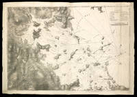
177510833London 5th August 1775. 705 by 1040mm 27.75 by 41 inches. Large aquatint and etched engraving on two sheets joined unfolded and uncut with the LVG watermark together with pamphlet quarto 280 by 230mm original blue wrappers typographic title pp. 5-12 there are no pages 3-4 which agrees with the John Carter Brown example. The first state of one of the most important Revolutionary War illustrations of Boston and its approaches accompanied by the very rare 12 page pamphlet by George Callender entitled 'Nautical remarks and observations for the chart of the harbour of Boston'. Callendar was the Master of HMS Romney. Commissioned in 1762 she served extensively in North America arriving in Boston in May 1768 to support the British during the enforcement of the Townshend Acts. Short of men it was the pressing of local men into service which increased tension in the town to a level which culminated in the Boston Massacre of 1770. This chart is part of a very large body of work known as the 'Atlantic Neptune' undertaken by Des Barres one of the greatest hydrographic achievements of the eighteenth century. The French and Indian War highlighted the lack of accurate mapping of the vast territories now under British control in North America. Samuel Holland was entrusted with the task of accurately mapping the northern portion of these territories. He proposed using the latest accurate methods which included astronomical readings and triangulation. In 1769 he was still working in Canadian waters but had instructed Callendar to undertake the survey of Boston. In England Des Barres was in charge of undertaking the detailed engraving. He set about providing the British government with more accurate mapping of the entire coastline of America and Canada. They proved to be of just as much use to the American rebel forces. This particular chart is notable for recording Boston as it was at the outbreak of hostilities. It illustrates the British defences before the siege. The second state in particular out of the four later ones would record the progress of the siege works constructed by the Americans around the city. As the title informs us it was surveyed in the year 1769 a troubled time in Boston. Extensive soundings are provided in the harbour. The road structure is accurately recorded as are the local towns. It even shows recorded field boundaries. An alphabetical key upper right identifies fourteen locations in the immediate area of Boston including batteries docks forts wharves and the all-important Charles-town Ferry. The accompanying pamphlet of sailing directions is rare. It was replaced soon after by a single sheet version entitled 'A Chart of the Harbour of Boston' which is sometimes found pasted to later states of the map. It is rarely found with the chart as here. Boston Engineering Department List of Maps of Boston pp. 70-71; Cumming British Maps of Colonial America pp.51-56; ESTC N12343 pamphlet; Guthorn 'British Maps of the American Revolution' 59/3 Holland's original manuscript; Krieger and Cobb Mapping Boston p. 106 plate 19; Nebenzahl Bibliography of printed battle plans 3; Sabin 10061 pamphlet; Sellers & Van Ee 945; Stevens Bibliography of the Atlantic Neptune unpublished pp. 211-216; Streeter II:706. unknown
1926577Paris: Société Nouvelle des Éditions d'Art Devambez 1926. Limited Edition. Fine. Edgar Chahine. 4to 13 x 10 3/4 inches 330 x 250 mm; 112 pp. Copy number XXIV of 30 HC copies on papier japon ancien with 26 plates frontispiece title vignette 5 in-text and 19 full-page. Each plate appears in 3 states: first state final state with remarques final state. This is one of 30 copies with roman numerals reserved for the artist and his friends "Imprimé pour l'artiste et ses amis" from an edition limited to 230 special copies; our copy also includes 4 additional plates also in 3 states an original drawing in reddish-orange crayon signed by Edgar Chahine and a signed copper etching plate for one of the illustrations. Superb red morocco binding by H. Blanchetière signed at foot of front turn-in. Covers with inlaid strapwork border of scarlet and turquoise morocco and elaborately tooled in gilt with scrolls and hatched decoration; spine titled in gilt with 3 strapwork compartments and 4 raised bands doublures of turquoise morocco within border of red morocco all tooled in gilt with the original copper plate for an etched portrait inset into front doublure gilt decorations on back doublure red silk moiré flyleaves marbled endpapers t.e.g. Original wrappers and spine bound in very slight rubbing to joints some light foxing; marbled board slipcase a little rubbed. <br /> <br /> Carteret IV 60; BNF34834086. A sumptuous edition of Maurice Barrès 1862 - 1923 travel impressions of Venice which he wrote in 1903 while living in Italy. Barrès was closely associated with the French Symbolists and the Italian Decadents like Gabriele d'Annunzio. He wrote a trilogy The Cult of the Self in 1888 and shortly thereafter was elected to the Chamber of Deputies and remained very involved in nationalist politics for the rest of his life. <br /> This superb 1926 edition is masterfully illustrated by Edgar Chahine 1874 - 1947 an artist of Armenian descent who studied in Venice for several years before moving to Paris. In his etchings he captures the mood and character of the city and its inhabitants. This super-illustrated edition includes the copper plate of the portrait of Chateaubriand p. 52 inset into the front doublure with the following inscription etched at the top of the plate after printing: "Achevé d'imprimer. 1926" followed by Chahine's signature. The book incorporates beautiful typography and a unique colophon set in the shape of the bow-iron that characterises the prow of all Venetian gondolas. Société Nouvelle des Éditions d'Art Devambez unknown
178019770London: J.F.W. Des Barres in the 'Atlantic Neptune' 1780. Engraved with aquatint period oxidized color. Good condition apart from expert restoration to center fold upper and lower margins. A very rare and highly important sea chart of Pensacola Harbor from the 'Atlantic Neptune' the finest marine atlas of North America's east coast produced during the Revolutionary War.<br/> <br/> This superbly drafted map features the magnificent natural harbor of Pensacola on the Florida panhandle. The town with its fort and carefully laid out streets is featured in the left-centre of the map. Another settlement "Campbell Town" is located further up the harbour toward where the entrance of the "Scambia" Escambia River. The borders of various land grants are demarcated and the countryside is elegantly detailed with aquatint features and coloured in a light brown-green wash. The chart precisely captures the features of the coast showing how the harbor is protected by two sandy bars of land the outer being Santa Rosa Island. The chart features a great deal of quantitative hydrographic information and instructions to mariners are written in the lower right of the map ensuring that it was by far the most accurate and comprehensive pilot for the harbor produced in the eighteenth-century. The present example is the first of two variants of this chart. It is important to note that the year this map was printed the region was caught up in the dramatic action of the Revolutionary War. The Spaniards who had just joined the war on the American side seized the British garrison at Fort Barrancas and West Florida remained in their possession for the duration of the war. Joseph Frederick Wallet Des Barres was born in Switzerland where his Huguenot ancestors had fled following the repeal of the Edict of Nantes. He studied under the great mathematician Daniel Bernoulli at the University of Basel before immigrating to Britain where he trained at the Royal Military College Woolwich. Upon the outbreak of hostilities with France in 1756 he joined the British Royal American Regiment as a military engineer. He came to the attention of General James Wolfe who appointed him to join his personal detail. During this period he also worked with the legendary future explorer James Cook on a monumental chart of the St. Lawrence River. Upon the conclusion of the Seven Years War Britain's empire in North America was greatly expanded and this required the creation of a master atlas featuring new and accurate sea charts for use by the Royal Navy. Des Barres was enlisted to survey the coastlines of Nova Scotia Newfoundland and the Gulf of St. Lawrence. With these extremely accurate surveys in hand Des Barres returned to London in 1774 where the Royal Navy charged him with the Herculean task of producing the atlas. Gradually he was forwarded the manuscripts of numerous advanced surveys conducted by British cartographers in the American Colonies Jamaica and Cuba. The result was The Atlantic Neptune which became the most celebrated sea atlas of its era containing the first systematic survey of the east coast of North America. Des Barres's synergy of great empirical accuracy with the peerless artistic virtue of his aquatint views created a work that "has been described as the most splendid collection of charts plates and views ever published" National Maritime Museum Catalogue. The Neptune eventually consisted of four volumes and Des Barres's dedication to the project was so strong that often at his own expense he continually updated and added new charts and views to various editions up until 1784 producing over 250 charts and views many appearing in several variations. All of these charts were immensely detailed featuring both hydrographical and topographical information such that in many cases they remained the most authoritative maps of the regions covered for several decades. Following the completion of the Neptune Des Barres returned to Canada where he remained for forty years becoming a senior political figure and a wealthy land owner living to the advanced age of 103.<br/> <br/> National Maritime Museum Henry Newton Stevens Collection HNS 173A & Catalogue III 144 p.384; Sellers & Van Ee Maps and Charts of North America and the West Indies 1663. J.F.W. Des Barres in the 'Atlantic Neptune' unknown
177933200London 1779. Engraved and aquatint map period hand colouring. 14 lettered references large inset with title as above. Rare revolutionary chart of the Hudson River showing the American defenses on the eve of the Battle of Fort Montgomery.<br/> <br/> On October 6 1777 a British force led by Lieutenant General Sir Henry Clinton attacked Forts Montgomery and Clinton from the landward side where the American defenses were only partially completed. Support from cannon fire from British ships on the Hudson River that had passed through the chevaux de frise on the lower river. By the end of the day both forts had fallen to the British who burned the forts and tore down the stonework buildings. However the battle was a pyrrhic victory for the British. The campaign against the forts caused delays in reinforcing General John Burgoyne at Saratoga where Americans forced the British surrender ten days later at the Battle of Saratoga before Clinton's forces could arrive. The present map which depicts the Forts and the River defenses prior to the battle is from The Atlantic Neptune the finest large scale sea atlas of the United States and Canadian Atlantic coastline ever produced. The maps in the atlas were produced over a seven-year period 1775-82 and are well known for their accurate portrayal of various sounds bays bars harbors as well as navigational hazards. This atlas was used extensively by the Royal Navy during the American Revolution. Des Barres studied under the great mathematician Daniel Bernoulli at the University of Basel before continuing on to the Royal Military College at Woolwich. On the outbreak of the Seven Years war in 1756 he joined the British Royal American Regiment as a military engineer. He came to the attention of General James Wolfe who appointed him to be his aide-de-camp. From 1762 Des Barres was enlisted to survey the coastlines of Nova Scotia Newfoundland and the Gulf of St.Lawrence while his colleague Samuel Holland charted the New England coast and further south. In 1774 Des Barres returned to England where he began work on the Neptune. His dedication to the project was so strong that often at his own expense he continually updated and added new charts and views up until 1784. That year he returned to Canada where he remained for a further forty years becoming a senior political figure and a wealthy land owner and living to the advanced age of 103. The Atlantic Neptune was the first British sea atlas of her North American colonies and one of the most important achievements of eighteenth century cartography. With an official commission from the Royal Navy Des Barres published the first volume in London in 1775 which was soon followed by further volumes. Des Barres' monumental endeavor eventually featured over two-hundred charts and aquatint views many being found in several states. All of the charts were immensely detailed featuring both hydrographical and topographical information. The Neptune met with the highest acclaim from the beginning and is today widely regarded as superior to all other atlases produced during its time. Henry Stevens identified only a single state of this chart issued coloured or uncoloured which appeared in some examples volume four part two of the Atlantic Nepture; the map however is not listed in the engraved list of maps for that section and given the rarity was likely not issued in all copies.<br/> <br/> National Maritime Museum: Henry Stevens Collection: HNS156; Cf. Phillips Atlases 1198; Hornsby Surveyors of Empire: Samuel Holland J.F.W. Des Barres and the Making of the Atlantic Neptune 2011. unknown
178026675London 1780. Aquatint and line engraving period hand colouring. Very rare first state of Des Barres's chart of the coast of Georgia.<br/> <br/> This fine chart is from "The Atlantic Neptune" one of the finest large scale sea atlases of the United States and Canadian Atlantic coastline ever produced. The maps in the atlas were produce over a seven-year period 1775-82 and are well known for their accurate portrayal of various sounds bays bars harbors as well as navigational hazards. This atlas was used extensively by the Royal Navy during the American Revolution. This is a detailed chart of the Georgia and upper Florida coastlines covering an area between the mouth of the River May to John's Island. The towns of Savannah Beaufort Hardwick and Sunbury are shown and the coastal Parishes in Georgia are names. To the west is noted "Indian Boundary Line." This very rare first state is larger than the subsequent two states without any detail added to the South Carolina coast and without the inset in the lower right corner added in or after 1780.<br/> <br/> Stevens 168a. unknown
177933200London 1779. Engraved and aquatint map period hand colouring. 14 lettered references large inset with title as above. Rare revolutionary chart of the Hudson River showing the American defenses on the eve of the Battle of Fort Montgomery.<br/> <br/>On October 6 1777 a British force led by Lieutenant General Sir Henry Clinton attacked Forts Montgomery and Clinton from the landward side where the American defenses were only partially completed. Support from cannon fire from British ships on the Hudson River that had passed through the chevaux de frise on the lower river. By the end of the day both forts had fallen to the British who burned the forts and tore down the stonework buildings. However the battle was a pyrrhic victory for the British. The campaign against the forts caused delays in reinforcing General John Burgoyne at Saratoga where Americans forced the British surrender ten days later at the Battle of Saratoga before Clinton's forces could arrive. The present map which depicts the Forts and the River defenses prior to the battle is from The Atlantic Neptune the finest large scale sea atlas of the United States and Canadian Atlantic coastline ever produced. The maps in the atlas were produced over a seven-year period 1775-82 and are well known for their accurate portrayal of various sounds bays bars harbors as well as navigational hazards. This atlas was used extensively by the Royal Navy during the American Revolution. Des Barres studied under the great mathematician Daniel Bernoulli at the University of Basel before continuing on to the Royal Military College at Woolwich. On the outbreak of the Seven Years war in 1756 he joined the British Royal American Regiment as a military engineer. He came to the attention of General James Wolfe who appointed him to be his aide-de-camp. From 1762 Des Barres was enlisted to survey the coastlines of Nova Scotia Newfoundland and the Gulf of St.Lawrence while his colleague Samuel Holland charted the New England coast and further south. In 1774 Des Barres returned to England where he began work on the Neptune. His dedication to the project was so strong that often at his own expense he continually updated and added new charts and views up until 1784. That year he returned to Canada where he remained for a further forty years becoming a senior political figure and a wealthy land owner and living to the advanced age of 103. The Atlantic Neptune was the first British sea atlas of her North American colonies and one of the most important achievements of eighteenth century cartography. With an official commission from the Royal Navy Des Barres published the first volume in London in 1775 which was soon followed by further volumes. Des Barres' monumental endeavor eventually featured over two-hundred charts and aquatint views many being found in several states. All of the charts were immensely detailed featuring both hydrographical and topographical information. The Neptune met with the highest acclaim from the beginning and is today widely regarded as superior to all other atlases produced during its time. Henry Stevens identified only a single state of this chart issued coloured or uncoloured which appeared in some examples volume four part two of the Atlantic Nepture; the map however is not listed in the engraved list of maps for that section and given the rarity was likely not issued in all copies.<br/> <br/>National Maritime Museum: Henry Stevens Collection: HNS156; Cf. Phillips Atlases 1198; Hornsby Surveyors of Empire: Samuel Holland J.F.W. Des Barres and the Making of the Atlantic Neptune 2011. unknown books
178019770London: J.F.W. Des Barres in the 'Atlantic Neptune' 1780. Engraved with aquatint period oxidized color. Good condition apart from expert restoration to center fold upper and lower margins. A very rare and highly important sea chart of Pensacola Harbor from the 'Atlantic Neptune' the finest marine atlas of North America's east coast produced during the Revolutionary War.<br/> <br/>This superbly drafted map features the magnificent natural harbor of Pensacola on the Florida panhandle. The town with its fort and carefully laid out streets is featured in the left-centre of the map. Another settlement "Campbell Town" is located further up the harbour toward where the entrance of the "Scambia" Escambia River. The borders of various land grants are demarcated and the countryside is elegantly detailed with aquatint features and coloured in a light brown-green wash. The chart precisely captures the features of the coast showing how the harbor is protected by two sandy bars of land the outer being Santa Rosa Island. The chart features a great deal of quantitative hydrographic information and instructions to mariners are written in the lower right of the map ensuring that it was by far the most accurate and comprehensive pilot for the harbor produced in the eighteenth-century. The present example is the first of two variants of this chart. It is important to note that the year this map was printed the region was caught up in the dramatic action of the Revolutionary War. The Spaniards who had just joined the war on the American side seized the British garrison at Fort Barrancas and West Florida remained in their possession for the duration of the war. Joseph Frederick Wallet Des Barres was born in Switzerland where his Huguenot ancestors had fled following the repeal of the Edict of Nantes. He studied under the great mathematician Daniel Bernoulli at the University of Basel before immigrating to Britain where he trained at the Royal Military College Woolwich. Upon the outbreak of hostilities with France in 1756 he joined the British Royal American Regiment as a military engineer. He came to the attention of General James Wolfe who appointed him to join his personal detail. During this period he also worked with the legendary future explorer James Cook on a monumental chart of the St. Lawrence River. Upon the conclusion of the Seven Years War Britain's empire in North America was greatly expanded and this required the creation of a master atlas featuring new and accurate sea charts for use by the Royal Navy. Des Barres was enlisted to survey the coastlines of Nova Scotia Newfoundland and the Gulf of St. Lawrence. With these extremely accurate surveys in hand Des Barres returned to London in 1774 where the Royal Navy charged him with the Herculean task of producing the atlas. Gradually he was forwarded the manuscripts of numerous advanced surveys conducted by British cartographers in the American Colonies Jamaica and Cuba. The result was The Atlantic Neptune which became the most celebrated sea atlas of its era containing the first systematic survey of the east coast of North America. Des Barres's synergy of great empirical accuracy with the peerless artistic virtue of his aquatint views created a work that "has been described as the most splendid collection of charts plates and views ever published" National Maritime Museum Catalogue. The Neptune eventually consisted of four volumes and Des Barres's dedication to the project was so strong that often at his own expense he continually updated and added new charts and views to various editions up until 1784 producing over 250 charts and views many appearing in several variations. All of these charts were immensely detailed featuring both hydrographical and topographical information such that in many cases they remained the most authoritative maps of the regions covered for several decades. Following the completion of the Neptune Des Barres returned to Canada where he remained for forty years becoming a senior political figure and a wealthy land owner living to the advanced age of 103.<br/> <br/>National Maritime Museum Henry Newton Stevens Collection HNS 173A & Catalogue III 144 p.384; Sellers & Van Ee Maps and Charts of North America and the West Indies 1663. J.F.W. Des Barres in the 'Atlantic Neptune' unknown books
178026675London 1780. Aquatint and line engraving period hand colouring. Very rare first state of Des Barres's chart of the coast of Georgia.<br/> <br/>This fine chart is from "The Atlantic Neptune" one of the finest large scale sea atlases of the United States and Canadian Atlantic coastline ever produced. The maps in the atlas were produce over a seven-year period 1775-82 and are well known for their accurate portrayal of various sounds bays bars harbors as well as navigational hazards. This atlas was used extensively by the Royal Navy during the American Revolution. This is a detailed chart of the Georgia and upper Florida coastlines covering an area between the mouth of the River May to John's Island. The towns of Savannah Beaufort Hardwick and Sunbury are shown and the coastal Parishes in Georgia are names. To the west is noted "Indian Boundary Line." This very rare first state is larger than the subsequent two states without any detail added to the South Carolina coast and without the inset in the lower right corner added in or after 1780.<br/> <br/>Stevens 168a. unknown books
177517671London: Published by J.F.W. Des Barres in 'The Atlantic Neptune' 1775. Copper-engraved and etched map with aquatint on two joined sheets. Printed on laid paper with `J Bates' watermark and `JB' countermark in excellent condition. Sheet size: 30 1/4 x 42 5/8 inches. With: The explanatory text leaf titled as above. 1p. folio 25 1/2 x 19 inches. The finest and most celebrated sea chart of Boston Harbor ever produced and a highly important Revolutionary War map depicting details relating to the Siege of Boston: with the very rare explanatory text leaf.<br/> <br/>This is one the most important maps contained in Des Barres' The Atlantic Neptune and one of the most significant large-scale maps of the Revolutionary War. It provides an invaluable record of Boston at the beginning of the war covering the area from the environs of the city out into the open waters of Massachusetts Bay. A particularly striking feature is the use of boldly etched and subtly aquatinted details to capture the diverse topography of the region including the numerous hills islands and river estuaries. It is important to remember that this was issued as a working sea-chart and as such the cartographer has naturally concentrated on features such as depth soundings indicated by detailed lines and based on surveys by Samuel Holland and George Callendar and the navigable channels between the harbor's numerous shoals which are delicately outlined in stipple-engraving. Holland's original manuscript map is today preserved in the British Hydrographic Library at Taunton Somerset. The present map shows the city of Boston with its streets carefully outlined occupying a pear-shaped peninsula a position that would soon prove precarious to its British defenders in the escalating conflict. This is the second state of five of Des Barres' chart and is identical to the Henry Stevens Collection variant 96D in the National Maritime Museum Greenwich. This state shows a number of notable changes when compared with the original and was evidently altered to take particular account of the Siege of Boston April 19 1775 to March 17 1776. Henry Stevens noted that this state depicted the addition of "Numerous Forts Batteries Redoubts &c. which have been inserted in many places notably on the Charles Town peninsula and on the mainland between 'Willis Creek' and 'Mystic River' also on the east and north side of 'Charles River' below 'Cambridge'.also to the south of 'Boston Neck' and 'Dorchester Neck'.This state is almost as rare as the first state. It is found in some copies of the earliest edition of the Neptune." The accuracy scope and artistic virtue of Des Barres's Chart of the Harbour of Boston was apparent to his contemporaries and it became the main source map of the area for decades to come. Joseph Frederick Wallet Des Barres was born in Switzerland where his Huguenot ancestors had fled following the repeal of the Edict of Nantes. He studied under the great mathematician Daniel Bernoulli at the University of Basel before immigrating to Britain where he trained at the Royal Military College Woolwich. Upon the outbreak of hostilities with France in 1756 he joined the British Royal American Regiment as a military engineer. He came to the attention of General James Wolfe who appointed him to join his personal detail. During this period he also worked with the legendary future explorer James Cook on a monumental chart of the St. Lawrence River. Upon the conclusion of the Seven Years War Britain's empire in North America was greatly expanded and this required the creation of a master atlas featuring new and accurate sea charts for use by the Royal Navy. Des Barres was enlisted to survey the coastlines of Nova Scotia Newfoundland and the Gulf of St. Lawrence. With these extremely accurate surveys in hand Des Barres returned to London in 1774 where the Royal Navy charged him with the Herculean task of producing the atlas. He was gradually forwarded the manuscripts of numerous advanced surveys conducted by British cartographers in the American Colonies Jamaica and Cuba of which the present map is based on the work of Samuel Holland conducted in the 1760s. The result was The Atlantic Neptune which became the most celebrated sea atlas of its era containing the first systematic survey of the east coast of North America. Des Barres's synergy of great empirical accuracy with the peerless artistic virtue of his aquatint views created a work that "has been described as the most splendid collection of charts plates and views ever published" National Maritime Museum Catalogue. The Neptune eventually consisted of four volumes and Des Barres's dedication to the project was so strong that often at his own expense he continually updated and added new charts and views to various editions up until 1784 producing over 250 charts and views many appearing in several variations. All of these charts were immensely detailed featuring both hydrographical and topographical information such that in many cases they remained the most authoritative maps of the regions covered for several decades. Following the completion of The Neptune Des Barres returned to Canada where he remained for a further forty years becoming a senior political figure and a wealthy land owner living to the advanced age of 103.<br/> <br/>Cf. GuthornBritish Maps of the American Revolution referring to Holland's original manuscript 59/3; Krieger & Cobb p.107 1781 issue; Lingel Atlantic Neptune N91.2; National Maritime Museum Henry Stevens Collection K0713 HNS 96D; National Maritime Museum Catalogue 78-83; Nebenzahl Bibliography 3; Stevens Bibliography of the Atlantic Neptune unpublished pp.211-216; Sellers & Van Ee 945. Published by J.F.W. Des Barres in 'The Atlantic Neptune' unknown books
177634921London: J. F. W. Des Barres 1776. Engraved view printed on laid paper engraved by James Newton after Pierie. Sheet size: 22 1/2 x 31 1/2 inches. First state. Repaired tears in lower margin. Rare view of Boston from Dorchester Heights published shortly after George Washington's first victory of the American Revolution.<br/> <br/>Following the Battles of Lexington and Concord American troops laid siege to Boston. Strategically Dorchester Heights offered commanding views of both Boston town and harbour. On March 4 1776 under the cover of darkness and with batteries firing from Roxbury and Cambridge to provide a diversion George Washington moved canon captured at Ticonderoga onto the Heights and fortified the position. Faced with little choice given the overwhelming strategic advantage General Howe retreated from Boston on March 17 giving George Washington and the Americans a decisive early victory in the war. The present view accomplished by British artillery officer William Pierie in 1773 depicts Boston Boston Harbor and Roxbury as it would have been seen by Washington and the American army. The Shirley-Eustis house the home of Governor William Shirley and later Governor William Eustis in Roxbury is visible in the middle ground and in the far distance the beacon is visible atop Beacon Hill. A rare view published in 1776 in the New England section of Des Barres monumental Atlantic Neptune. Joseph Frederick Wallet Des Barres was born in Switzerland where his Huguenot ancestors had fled following the repeal of the Edict of Nantes. He studied under the great mathematician Daniel Bernoulli at the University of Basel before immigrating to Britain where he trained at the Royal Military College Woolwich. Upon the outbreak of hostilities with France in 1756 he joined the British Royal American Regiment as a military engineer. He came to the attention of General James Wolfe who appointed him to join his personal detail. Des Barres returned to London in 1774 where the Royal Navy charged him with the Herculean task of producing an atlas of sea charts of the American coast. The result was The Atlantic Neptune which became the most celebrated sea atlas of its era containing the first systematic survey of the east coast of North America. Des Barres's synergy of great empirical accuracy with the peerless artistic virtue of his aquatint views created a work that "has been described as the most splendid collection of charts plates and views ever published" National Maritime Museum Catalogue. The Neptune eventually consisted of four volumes and Des Barres's dedication to the project was so strong that often at his own expense he continually updated and added new charts and views to various editions up until 1784 producing over 250 charts and views many appearing in several variations. Following the completion of The Neptune Des Barres returned to Canada where he remained for a further forty years becoming a senior political figure and a wealthy land owner living to the advanced age of 103.<br/> <br/>Henry Stevens Collection HNS97; Deak 132. J. F. W. Des Barres unknown books
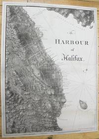
1781M10024London c.1781. Very good few marginal tears expertly repaired; backed on acid free tissue paper for long term preservation. Notes: scarce and superb sea chart constructed for the use of the British Navy shows The Harbour of Halifax Nova Scotia during the late 18th century. <br><br>Colonel Joseph Frederick Wallet DesBarres 1721 – 1824 was a hydrographer cartographer military engineer and landscape artist who served in the Seven Years War in part as the aide-de-camp to General James Wolfe. He also created the monumental four volume Atlantic Neptune which was the most important collection of maps charts and views of North America published in the eighteenth century. Finally he was the Governor of Cape Breton Island and Prince Edward Island. Size : 837x616 mm 32.95x24.25 Inches Coloring: Black & White Category: Maps City Maps; Maps Canada East Nova Scotia; unknown
177634921London: J. F. W. Des Barres 1776. Engraved view printed on laid paper engraved by James Newton after Pierie. Sheet size: 22 1/2 x 31 1/2 inches. First state. Rare view of Boston from the road to Dorchester published shortly after George Washington's first victory of the American Revolution.<br/> <br/> Following the Battles of Lexington and Concord American troops laid siege to Boston. Strategically Dorchester Heights offered commanding views of both Boston town and harbour. On March 4 1776 under the cover of darkness and with batteries firing from Roxbury and Cambridge to provide a diversion George Washington moved canon captured at Ticonderoga onto the Heights and fortified the position. Faced with little choice given the overwhelming strategic advantage General Howe retreated from Boston on March 17 giving George Washington and the Americans a decisive early victory in the war. The present view accomplished by British artillery officer William Pierie in 1773 depicts Boston Boston Harbor and Roxbury as it would have been seen by Washington and the American army. The Shirley-Eustis house the home of Governor William Shirley and later Governor William Eustis in Roxbury is visible in the middle ground and in the far distance the beacon is visible atop Beacon Hill. A rare view published in 1776 in the New England section of Des Barres monumental Atlantic Neptune. Joseph Frederick Wallet Des Barres was born in Switzerland where his Huguenot ancestors had fled following the repeal of the Edict of Nantes. He studied under the great mathematician Daniel Bernoulli at the University of Basel before immigrating to Britain where he trained at the Royal Military College Woolwich. Upon the outbreak of hostilities with France in 1756 he joined the British Royal American Regiment as a military engineer. He came to the attention of General James Wolfe who appointed him to join his personal detail. Des Barres returned to London in 1774 where the Royal Navy charged him with the Herculean task of producing an atlas of sea charts of the American coast. The result was The Atlantic Neptune which became the most celebrated sea atlas of its era containing the first systematic survey of the east coast of North America. Des Barres's synergy of great empirical accuracy with the peerless artistic virtue of his aquatint views created a work that "has been described as the most splendid collection of charts plates and views ever published" National Maritime Museum Catalogue. The Neptune eventually consisted of four volumes and Des Barres's dedication to the project was so strong that often at his own expense he continually updated and added new charts and views to various editions up until 1784 producing over 250 charts and views many appearing in several variations. Following the completion of The Neptune Des Barres returned to Canada where he remained for a further forty years becoming a senior political figure and a wealthy land owner living to the advanced age of 103.<br/> <br/> Henry Stevens Collection HNS97; Deak 132. J. F. W. Des Barres unknown
177634405London: J. F. W. Des Barres 1776. Engraved with color wash and outline color. Sheet: 31 x 42 1/4 inches. Expert restoration primarily at the upper margin. Two sheets joined both watermarked "J.Bates" and countermarked "JB". Fourth state of five. Among the earliest charts published by Des Barres were those relevant to the crisis in New England as the War of Independence broke out.<br/> <br/>This chart depicts the coast of Massachusetts from Salem to Scituate Harbor and includes the complicated hydrography of Boston Harbor and the confluent rivers. A considerable amount of coastal topography is included obviously relevant to warships. Fundamentally a chart for navigators it includes soundings and shoals with particularly strong detail along the Charles and Mystic Rivers as well as in Salem and Marblehead. Samuel Holland was the lead surveyor. In 1764 he was named Surveyor General of both the Province of Quebec and the Northern District of North America. He had a considerable staff and the British Navy assisted in providing soundings. From 1770 to 1774 his squad worked exclusively on northeastern colonies that soon became part of the United States. The surveys that derived from the industry of their work were the most accurate ever made to that time. They were sent to London where Des Barres supervised the engraving and publication. The charts were very soon put to use. Des Barres of Swiss-Huguenot extraction studied under the great mathematician Daniel Bernoulli at the University of Basel before continuing on to the Royal Military College at Woolwich. Upon the outbreak of hostilities with France in 1756 he joined the British Royal American Regiment as a military engineer. He came to the attention of General James Wolfe who appointed him to join his personal detail. During this period he also worked with the future legendary explorer James Cook on a monumental chart of the St. Lawrence River. From 1762 Des Barres was enlisted to survey the coastlines of Nova Scotia Newfoundland and the Gulf of St. Lawrence while his colleague Samuel Holland charted the New England coast. He also managed to gain access to some surveys of the American South Cuba and Jamaica. In 1774 Des Barres returned to England where he began work on The Neptune. His dedication to the project was so strong that often at his own expense he continually updated and added new charts and views up until 1784. That year he returned to Canada where he remained for a further forty years becoming a senior political figure and a wealthy land owner and living to the advanced age of 103.<br/> <br/>Stevens Collection 94d ; cf. Hornsby Surveyors of Empire: Samuel Holland J.F.W. Des Barres and the Making of the Atlantic Neptune. 2011. J. F. W. Des Barres unknown books
189723477Tirage pour les XX, signé : le titre inaugural Paris, Bibliothèque Charpentier, Eugène Fasquelle, 1897, 1900 et 1902. 3 vol. (140 x 185 mm) de 491, 552 et 301 p. Demi-maroquin à coins bleu nuit, dos à nerfs, titres dorés, têtes dorées, doubles couvertures et dos conservés, étuis bordés (reliure signée de J.-P. Miguet). Edition originale. Un des 20 exemplaires numérotés sur vélin d'Arches réservés pour les XX, pour chacun des trois volumes. Ils ne sont pas annoncés à la justification de l'éditeur et viennent avant les 25 exemplaires sur Hollande (après 10 exemplaires sur Japon). Le premier volume est signé par Maurice Barrès à la justification, selon le principe des parutions de la «Société des XX».
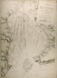
177920759London: Published by J. F. W. Des Barres in 'The Atlantic Neptune' 1779. Black and white copper engraving. Large repaired tear 12" from bottom edge parallel to centerfold. 4" repaired split from bottom in centerfold. Thin uneven margins. Plate size: 30 1/4 x 22 1/8 inches. This is a fantastic sea chart of the Delaware coast from the 'The Atlantic Neptune' which is universally recognized as one of the most magnificent atlases ever made.<br/> <br/>This superb sea chart constructed for the use of the British Navy shows the major part of the Delaware coast from Rehobeth to Bombay Hook as well as the opposing south New Jersey shore. 'The Atlantic Neptune' was the first great marine atlas and one of the great achievements of eighteenth century cartography. When publication in England began in 1774 it contained over 250 charts and views of the North American and Canadian coasts. The charts were intensely detailed and contained both hydrographical and topographical details. The Neptune was compiled and published for the Royal Navy by Joseph F. W. Des Barres a Swiss cartographer who joined the Royal American Regiment as a surveyor. Des Barres fought in the French and Indian wars and was enlisted to survey the Canadian coastline. While his fellow surveyor Samuel Holland charted the New England coast Des Barres mapped the shoreline of Nova Scotia Newfoundland and the St. Lawrence River regions. In 1774 Des Barres returned to England where he compiled and published his monumental atlas; his dedication to the project was so strong that he published an updated version of the work every year until 1784. Des Barres' work was so superior to any other contemporary atlas that the maps were used as the standard charts of the East coast for over 50 years. The Neptune remains one of the most important atlases ever printed its views and maps chart as aspect of the history of North America and now allow us to glimpse this land drastically changed by the passage of time.<br/> <br/>Snyder City of Independence p. 271; Stevens 158. Published by J. F. W. Des Barres in 'The Atlantic Neptune' unknown books
191548305Paris Edouard Pelletan 1915 In-8, maroquin gris anthracite orn sur chaque plat d'une grande composition compartimente par des arabesques et dore petits fers, dlimitant un encadrement de semis de points et d'ovales voquant des graines, avec des motifs floraux aux angles et des gerbes de bl; nom de l'auteur et titre de l'ouvrage pousss or sur le dos nerfs, filet or sur les coupes; rappel du dcor sur les larges encadrements intrieurs, doublures de maroquin bordeaux, gardes de tabis bronze, doubles gardes de papier marbr, tranches dores sur brochure, couverture illustre. Etui (Jules Chadel del. - Joly rel. 1916).Premire dition illustre, comportant 48 bois originaux de Paul-Emile Colin, dont un frontispice, une vignette de titre rpte sur la couverture et 46 in-texte. Tirage limit 580 exemplaires numrots. Un des 30 exemplaires sur papier de Chine, enrichi du prospectus illustr de l'diteur. Trs rare reliure dcore de Jules Chadel. Dessinateur dans l'atelier d'orfvrerie Henri Vever, il fut encourag par son patron et devint un illustrateur-graveur qui connut un trs grand succs durant les annes trente; il fit quelques maquettes de reliures, presque exclusivement pour Henri Vever. De la bibliothque Henri Vever (ex-libris pouss or au bas de la premire doublure).
17763748<b>Striking Casco Bay Chart from the Atlantic Neptune 1776</b><br /><br />This is an exceptional chart of the coast of Maine between Cape Elizabeth and Popham from the early Revolutionary War period. It is from Des Barres' monumental <i>Atlantic Neptune</i> a sea atlas published by the British Admiralty during the last quarter of the 18th century. The <i>Atlantic Neptune</i> has been called "the most splendid collection of charts plans and views ever published." <br /><br />The present chart includes all of Casco Bay naming the larger islands and extends east to include Seguin "Segevin Island" and Georgetown Islands. Among the numerous geographic features named are Great Jebieg Chebeague Merrymeeting Bay Segadahock River Arrowsick Island and Halfway Road i.e. Rock. Roads are shown on the chart as are individual buildings. <br /><br />The chart is dated July___ 1776 i.e. with a prominent space after the month as if a date were going to be inserted. There is no type-stamped "15" at the upper right as called for in some copies of state "b" of the Stevens Catalogue. <br /><br />The chart was folded into four vertical panels about 30 1/4 x 12" to accommodate being "bound up in tall narrow form" Stevens' Catalogue p. vii. The chart paper has the LVG watermark consistent with the earlier issues of the chart. <br />A scarce early state of a desirable chart. <br /><br /><b>References:</b> Stevens <i>Catalogue of the Atlantic Neptune</i>: 105 State: b. Sellers & Van Ee <i>Maps and Charts of North America and the West Indies</i> 1750-1789: 855. <br /><br /><b>Condition: </b>A wonderfully clean example of a striking chart of Casco Bay.<br /><br />ICN 3763. From The Atlantic Neptune.
178134403London: J.F.W. Des Barres 1781. Hand-colored line engraving and aquatint. Two plates printed on two sheets joined with 8 views arranged in 5 rows. Sheet size: 32 x 43 3/4 inches. 8 navigational profile views from the greatest of all 18th century sea atlases.<br/> <br/> These eight views of sites in and around Nova Scotia were designed to give navigators additional information to the soundings on the charts of these same places. Several of the placenames have changed but Beaver Island Port Bickerton Chedabucto Bay and Canso remain. This is the 5th of 5 states with many ships and aquatinted features to the landscapes added to the original plates. Des Barres of Swiss-Huguenot extraction studied under the great mathematician Daniel Bernoulli at the University of Basel before continuing on to the Royal Military College at Woolwich. Upon the outbreak of hostilities with France in 1756 he joined the British Royal American Regiment as a military engineer. He came to the attention of General James Wolfe who appointed him to join his personal detail. During this period he also worked with the future legendary explorer James Cook on a monumental chart of the St. Lawrence River. From 1762 Des Barres was enlisted to survey the coastlines of Nova Scotia Newfoundland and the Gulf of St. Lawrence while his colleague Samuel Holland charted the New England coast. He also managed to gain access to some surveys of the American South Cuba and Jamaica. In 1774 Des Barres returned to England where he began work on The Neptune. His dedication to the project was so strong that often at his own expense he continually updated and added new charts and views up until 1784. That year he returned to Canada where he remained for a further forty years becoming a senior political figure and a wealthy land owner and living to the advanced age of 103.<br/> <br/> The American Revolution in drawings and prints; a checklist of 1765-1790 graphics in the Library of Congress / Compiled by Donald H. Cresswell with a foreword by Sinclair H. Hitchings. Washington : 1975 no. 397-404; #61e Henry Stevens Collection. J.F.W. Des Barres unknown
177634405London: J. F. W. Des Barres 1776. Engraved with color wash and outline color. Sheet: 31 x 42 1/4 inches. Expert restoration primarily at the upper margin. Two sheets joined both watermarked "J.Bates" and countermarked "JB". Fourth state of five. Among the earliest charts published by Des Barres were those relevant to the crisis in New England as the War of Independence broke out.<br/> <br/> This chart depicts the coast of Massachusetts from Salem to Scituate Harbor and includes the complicated hydrography of Boston Harbor and the confluent rivers. A considerable amount of coastal topography is included obviously relevant to warships. Fundamentally a chart for navigators it includes soundings and shoals with particularly strong detail along the Charles and Mystic Rivers as well as in Salem and Marblehead. Samuel Holland was the lead surveyor. In 1764 he was named Surveyor General of both the Province of Quebec and the Northern District of North America. He had a considerable staff and the British Navy assisted in providing soundings. From 1770 to 1774 his squad worked exclusively on northeastern colonies that soon became part of the United States. The surveys that derived from the industry of their work were the most accurate ever made to that time. They were sent to London where Des Barres supervised the engraving and publication. The charts were very soon put to use. Des Barres of Swiss-Huguenot extraction studied under the great mathematician Daniel Bernoulli at the University of Basel before continuing on to the Royal Military College at Woolwich. Upon the outbreak of hostilities with France in 1756 he joined the British Royal American Regiment as a military engineer. He came to the attention of General James Wolfe who appointed him to join his personal detail. During this period he also worked with the future legendary explorer James Cook on a monumental chart of the St. Lawrence River. From 1762 Des Barres was enlisted to survey the coastlines of Nova Scotia Newfoundland and the Gulf of St. Lawrence while his colleague Samuel Holland charted the New England coast. He also managed to gain access to some surveys of the American South Cuba and Jamaica. In 1774 Des Barres returned to England where he began work on The Neptune. His dedication to the project was so strong that often at his own expense he continually updated and added new charts and views up until 1784. That year he returned to Canada where he remained for a further forty years becoming a senior political figure and a wealthy land owner and living to the advanced age of 103.<br/> <br/> Stevens Collection 94d ; cf. Hornsby Surveyors of Empire: Samuel Holland J.F.W. Des Barres and the Making of the Atlantic Neptune. 2011. J. F. W. Des Barres unknown
178134403London: J.F.W. Des Barres 1781. Hand-colored line engraving and aquatint. Two plates printed on two sheets joined with 8 views arranged in 5 rows. Sheet size: 32 x 43 3/4 inches. 8 navigational profile views from the greatest of all 18th century sea atlases.<br/> <br/>These eight views of sites in and around Nova Scotia were designed to give navigators additional information to the soundings on the charts of these same places. Several of the placenames have changed but Beaver Island Port Bickerton Chedabucto Bay and Canso remain. This is the 5th of 5 states with many ships and aquatinted features to the landscapes added to the original plates. Des Barres of Swiss-Huguenot extraction studied under the great mathematician Daniel Bernoulli at the University of Basel before continuing on to the Royal Military College at Woolwich. Upon the outbreak of hostilities with France in 1756 he joined the British Royal American Regiment as a military engineer. He came to the attention of General James Wolfe who appointed him to join his personal detail. During this period he also worked with the future legendary explorer James Cook on a monumental chart of the St. Lawrence River. From 1762 Des Barres was enlisted to survey the coastlines of Nova Scotia Newfoundland and the Gulf of St. Lawrence while his colleague Samuel Holland charted the New England coast. He also managed to gain access to some surveys of the American South Cuba and Jamaica. In 1774 Des Barres returned to England where he began work on The Neptune. His dedication to the project was so strong that often at his own expense he continually updated and added new charts and views up until 1784. That year he returned to Canada where he remained for a further forty years becoming a senior political figure and a wealthy land owner and living to the advanced age of 103.<br/> <br/>The American Revolution in drawings and prints; a checklist of 1765-1790 graphics in the Library of Congress / Compiled by Donald H. Cresswell with a foreword by Sinclair H. Hitchings. Washington : 1975 no. 397-404; #61e Henry Stevens Collection. J.F.W. Des Barres unknown books
192838683Paris chez l'Artiste 1928 In-4, maroquin havane orn sur le premier plat d'une composition voquant des guitares suggres par des cercles coups par des lignes droites obliques, pousss or et mosaqus en maroquin beige dont certains se prolongent sur le second plat en passant par le dos sans nerfs; larges encadrements intrieurs orns de filets dors, doublures et gardes de soie moire havane, doubles gardes de papier marbr, tte dore, non rogn, couverture imprime. Etui (S. et Y. Moineau).48 eaux-fortes originales de P.-A. Bouroux, dont une vignette de titre, 12 hors-texte et 35 in-texte. Tirage limit 221 exemplaires numrots. Un des 175 exemplaires sur vlin de Rives. Belle reliure dcore signe par S. et Y. Moineau qui exercrent Paris de 1945 1960.
192238684Paris Les Cent Bibliophile 1922 In-8, maroquin bleu nuit orn sur les plats d'un grand encadrement d'un filet dor et d'une composition florale de branches de rosiers mosaques en maroquin havane, brun, rouge et vert; rappel du dcor sur le dos quatre nerfs et les larges encadrements intrieurs, doublures et gardes de soie moire rouge, tranches dores sur brochure, couverture illustre. Chemise, tui (Bernasconi).42 pointes sches en couleurs de Malo Renault (dont un frontispice, un hors-texte et 40 in-texte), ainsi que 2 compositions imprimes et gaufres illustrant chacune un plat de la couverture, et une ornementation rpte sur les 13 pages de la prface et encadrant le texte. Tirage unique limit 130 exemplaires numrots sur vlin de Rives. Edition originale de la prface Comment naquit Brnice. Exemplaire imprim au nom du bibliophile Henri Beraldi, enrichi d'une pointe sche originale inutilise. Superbe reliure dcor floral. Des bibliothques Henri Beraldi (Paris, Blaizot, 1935, IV, n10) et Sczaniecki (Paris, 1974, I, n141).