Robert DesnosBiblio.com
111 résultats
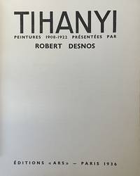
19362381Paris 1936. Editions Ars. In original paper. In fine condition. Editions Ars. In original paper. 23 plates. Edition of 415 numbered copies. One of the 100 on Arches containing the original litograph numbered and signed by Tihanyi. This print inserted in the work - self-portrait of the artist - is very often absent. unknown
194266748Paris: Gallimard 1942. Fine. Gallimard Paris 1942 12 x 19 cm broché Collective first edition for which it was not drawn from great papers one of the review copies service. Back insolated some traces. Rare and beautiful autograph signed by Robert Desnos Jean Galtier-Boissière: ""To Jean Galtier-Boissière this book is not worth a good glass of good wine but better than a kick in the ass. Desnos to his wife in terms less raw Desnos "" Gallimard unknown
1792005599Paris: Veuve Hérissant 1792. Half Calf. Very Good. Exceptionally richly hand-colored French atlas. Elephantine folio 56 by 44 cm. Following title page which contains table of contents as well six two paged hand-colored maps. The first map with its large allegorical cartouche is especially spectacular but all the maps are beautiful and noteworthy for the quality of their coloring. Scarce with copies held by BNF Bibliotheque Sainte-Genevieve Leiden and the National Library of Scotland according to OCLC and not clear whether all of these copies are hand-colored. Corner dampstains most pronounced on title then receding as progress. While unquestionably noticeable on the first map in our view it doesn't seriously detract from the beauty of the map. Other light scattered soiling which again we do not find disconcerting. Some scuffing of the binding. While half calf technically the calf coverage of the boards is minimal. Veuve Hérissant unknown
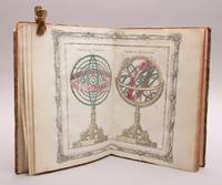
95730Paris Chez le Sr Desnos Ingénieur-Géographe pour les Glôbes et Sphéres et Libraire de sa Majesté Danois 1781. 4to. 23 x 30 cm. Engraved title-page 26 engraved double-paged and hand-coloured maps. Contemporary half calf gilt spine red leather label. Rubbed. . <br/><br/><em>1. Le systême de Ptolémée Thico-Brahé Copernic et Descartes. 2. Sphéres de Ptolémée et de Copernic. 3. Sphéres droite et paralléle. 4. Démonstration géométrique des spéres. 5. Glôbe terrestre et Céleste. 6. A. Position réspective des peuples de la terre. B. Suite de la planche précédente. 7. Hémisphère Occidental. 8. Hémisphère Occidental. 9. Mappe-Monde. 10. L`Europe. 11. La France. 12. La Suisse. 13. L`Italie. 14. L`Espagne. 15. Les Isles Britannique. 16. Les Pays-Bas. 17. L`Allemagne. 18. La Hongrie. 19. La Pologne. 20. La Dannemarc. 21. La Suède et Norvége. 22. La Russie Européene. 23. La Turquie Eoropéene. 24. L`Asie. 25. L`Afrique. 26. L`Amerique. </em> hardcover
176522130Paris 1765. 4to. Grangé Guillyn Desnos et al. Contemporary gold- and blind-tooled marbled calf sewn on 5 supports with the corresponding raised bands on the spine a red morocco title label on the spine lettered in gold a blind-tooled triple fillet border on both boards gold-tooled board edges red edges marbled end papers. With a double-page frontispiece by Le Charpentier after De Sève with a view of the Place de la Concorde in Paris 2 large folding engraved maps of France by Rizzi Zannoni 40 double-page engraved maps and charts of France 10 folding road maps 2 "Cartes odographiques" with the distances between French cities and 3 double-page engraved part-titles all but the frontispiece and titles in a contemporary hand colouring. 2 works in 1 volume the first in 3 parts. 15 1 blank 3 1 blank 8 10; 16 pp. 56 plates First edition of a rare atlas of France mapping out the country from all possible useful points of view. The work includes "analytical" maps which divide France in many ways showing not only the various geographical and political divisions of the country but also the military ecclesiastical juridical genealogical commercial and financial divisions and even hunting territories. The atlas also includes a small sea-atlas with 3 charts showing the French coasts as well as a French road atlas mapping out all the travelling routes of France. The maps were all made under the direction of Louis Charles Desnos 1725-1805 but they were drawn by various mapmakers. Several of the analytical maps and all sea charts were drawn by Rizzi Zannoni and all the road maps by Michel Royal geographer and engineer of the Paris Observatoire. This important geographical compendium drawn primarily from the cartographic collections of Desnos is structured around three series of maps: the Tableau analytique de la France Le petit Neptune and L'indicateur fidèle. All maps 52 in total were newly made and dated 1763-5. In the present composition published by Louis Brion de la Tour ca. 1745-1823 the atlas is in first edition and exactly as issued with all maps including the part-titles dated 1765. Most maps are set within broad ornamental borders and are attractively hand-coloured. After the maps three additional texts follow: the Prospectus du guide des voyageurs pour des routes royales & particulières de la France & autres a Catalogue alphabetique des routes royales et particulières and a Catalogue alphabetique du supplement des 1380 villes de France. Of particular interest is the added catalogue of the stock of Mr. Desnos who was a Paris publisher bookseller and engineer geographer of globes and spheres at Paris. All parts of the present atlas are offered for sale in the catalogue separately as well. With remnants of 2 bookplates mounted on the front pastedown an ownership annotation "Mailly" on the title page. The boards are somewhat scratched with some loss of material. Two maps are browned. Otherwise in very good condition.l Cf. Phillips 2990-2993 all three parts separate with the "Neptune" and "L'Indicateur" dated 1766; Quérard I 515. hardcover
193048215Paris: Nrf 1930. Fine. Nrf Paris 1930 12 x 19 cm broché First edition an advance service de presse copy Handsome autograph inscription from Robert Desnos to Janine and Raymond Queneau : "". devant qui j'ai repassé le conseil de revision who were my council of review"" enriched with a drawing showing a little elephant holding up Robert Desnos' name in its trunk One joint very slightly cracked at foot. Nrf unknown
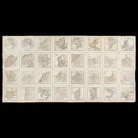
42554Paris : Desnos circa 1771. Thirty-two copperplate engraved maps each measuring 95 x 95 mm image and 115 x 115 mm sheet numbering in the upper right corner of each map; laid on linen overall measurements 470 x 940 mm; inscribed verso Presented by the Marquis St. Simon to A. Gordon with the initials M. G. another Gordon family member below and with another inscription crossed out; housed in a red morocco presentation case with gilt-tooled decoration and title ATLAS 125 x 125 mm lined with blue paper and silk. A rare configuration - possibly unique - of Desnos' Almanach géographique ou petit atlas élémentaire dissected and laid on linen in a fully contemporary presentation case. An inscription records that the cased atlas was presented - presumably to its second owner - by Claude Anne de Rouvroy Marquis de Saint-Simon-Montbléru 1743-1819 a highly significant figure in the American Revolutionary War. The Marquis de Saint-Simon sailed for the Caribbean in 1779 as a colonel in the Touraine regiment. In 1781 he arrived at Jamestown Virginia in command of 3500 French soldiers where he joined forces with a smaller American army under Lafayette. Between them Saint-Simon and Lafayette conducted the siege of Yorktown during which Saint-Simon's force succeeded in preventing Cornwallis and his troops from escaping northwards along the road to Williamsburg. Although he was badly wounded in the leg Saint-Simon refused to leave the lines until the British surrendered and insisted on mounting his horse in order to take part in the surrender ceremony. Saint-Simon was personally thanked by Washington for his contribution to the American cause in a letter written just before his return to the West Indies Library of Congress George Washington Papers Series 4 General Correspondence: George Washington to Saint-Simon October 24 1781. He was also made one of the original members of the Society of the Cincinnati the private patriotic organisation founded by Washington. In 2018 the American Revolution Institute of the Society of the Cincinnati in Washington D.C. announced its acquisition of a portrait of Saint-Simon painted between 1815 and 1818 by the Spanish artist Vicente Lopez. It is the only portrait in American institutional collections of this lesser-known yet important participant in the Revolutionary War. Louis-Charles Desnos was one of the most prolific and influential map and globemakers of his age at a time when Paris was the leading centre of map production in Europe. Desnos married the widow of Nicolas Hardy son of Jacques Hardy a globemaker active during the period 1738-1745. Desnos acquired Hardy's inventory and tools and expanded the company also acquiring the inventories of the Jaillot family and of Nicolas de Fer. Desnos would be appointed Royal Globemaker to King Christian VII of Denmark and continued publishing throughout the late eighteenth century. Desnos first published his miniature atlas in 1770; it would be reissued in two volumes later the same year and again in 1771 with the addition of plate numbers to the maps as in the present example. The maps are titled: Hemisphere Orientale; Hemisphere Occidentale; Europe; Asie; Afrique; Amerique Septentrionale; Amerique Meridionale; Royaume de France; La Suisse diviseÌe en ses xiii cantons et ses allies; L’Italie; DucheÌs de Savoye et Piemont; Le Royaume de Naple et de Sicile; Royaume de Sardaigne; Royaume de Corse; Espagne et Portugal; Royaume de Portugal; Les Isles Britanniques; Pays Bas septentrionaux; Pays Bas meridionaux; L’Empire d’Allemagne; Royaume de Boheme na. les 16 cercles portent le nom de leurs capitales; Royaume de Prusse; Le Royaume de Hongrie; Royaume de Pologne; Royaume de Danemarck; Suede et Norwege; Suede et Norwege septentrionales; Suede et Norwege meridionales; Russie d’Europe; Turquie d’Europe; Russie d’Asie partie occidentale; Russie d’Asie partie orientale. We can locate no other examples which have been laid on linen and specially housed in a morocco case. The present example originally owned by a significant figure in the Revolutionary War is possibly a uniquely prepared copy with a purpose-made sturdy leather case portable and eminently suited to being carried in the pocket of a military coat. hardcover
19261689151926. MASSON André. C'est les bottes de 7 lieues Cette phrase "Je me vois". By Robert Desnos. 13 ff. illustrated with 4 etchings by Masson. Folio 423 x 328 mm. bound in publisher's wrappers in a new cloth folding box. Paris: Galerie Simon Daniel-Henry Kahnweiler 1926. A fine copy of the most beautiful of the books Kahnweiler published with Masson's illustrations and the first book by Robert Desnos with illustrations. One of 90 copies on Arches signed by Masson and Desnos from a total edition of 100. Saphire and Cramer ANDRE MASSON: The Illustrated Books. No. 3. hardcover
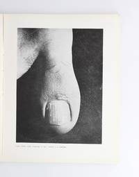
192988960Paris: Documents 1929. Fine. ""Documents . was made into a laboratory a genesis a crucible a rebellion a madness in short an avant-garde."" Jean Jamin Documents Paris 1929-1930 nº 1 à 7 avril 1929 - décembre 1929 ; nº 1 à 8 janvier 1930- octobre 1930 22 x 27.50 cm 15 volumes brochés sous coffret First edition 15 issues in 15 separate instalments abundantly illustrated with black and white photographs. Complete with the special issue Hommage à Picasso #3 1930 and the index for the year 1929 published as a separate 8-page stapled booklet. Some spines slightly faded not affecting the text occasional minor foxing along the margins of certain covers Presented in a custom slipcase with a flat spine in blue morocco title stamped in palladium and spine framed in palladium decorative blue paper boards sky-blue suede doublures; a handsome ensemble signed Boichot. Complete series of this legendary and non-conformist magazine founded by Georges Bataille which gave voice to fields of art and knowledge unrecognised by official culture or considered controversial: popular literature jazz cabaret advertising everyday life Annie Pirabot along with so-called primitive art and objects. Texts by Jean Babelon Jacques Baron Georges Bataille Alejo Carpentier Arnaud Dandieu Robert Desnos Carl Einstein Roger Gilbert-Lecomte Marcel Griaule Juan Gris Eugene Jolas Marcel Jouhandeau Michel Leiris Georges Limbour Marcel Mauss Léon Pierre-Quint Jacques Prévert Raymond Queneau Zdenko Reich Paul Rivet Georges Ribemont-Dessaignes Georges-Henri Rivière André Schaeffner Roger Vitrac among others. Numerous full-page artistic contributions by Hans Arp Constantin Brancusi Giorgio De Chirico Alberto Giacometti Juan Gris Henri Laurens Fernand Léger André Masson Joan Miró Pablo Picasso Joseph Sima etc. The journals pioneering and interdisciplinary approach established it as one of the most important publications of the century: a dissident voice against the doctrinaire surrealism of André Breton Documents was conceived as a war machine against received ideas in Batailles own words and gathered an eclectic array of contributorsacademics ex-Dadaist and Surrealist painters and poets philosophers. It remains renowned for its striking juxtapositions: Rather than assemble documents from separate fields rather than uphold the usual subordination of image to text the journal gives photography drawing and image the privilege of being the most primal substance or the most original trace of human expression Georges Sebbag. Ethnography Documents is remembered above all for Batailles radical ethnographic stance focused on the material and detached from aesthetic criteria and the usual fascination with exoticism. These groundbreaking views foreshadow the Collège de sociologie that Bataille would later found with Michel Leiris Roger Caillois and Jules Moncrot. They are also reflected in the journal through numerous photographs of masks stones and other non-Western artistic creations Siberian Chinese. set alongside modern artworks including drawings by Klee and paintings by Picasso. Bataille also collaborated with the notorious Hans Bellmer who would go on to illustrate the famous second edition of Histoire de lil to create a terrifying portrait of the Hindu goddess of destruction Kali. photography The journal places particular emphasis on photography. Among its most celebrated contributions are the close-up photographs of toes by Jacques-André Boiffard accompanying Batailles essay on the foot in issue no. 6: The point of this article lies in an insistence on directly and explicitly challenging what seduces without relying on poetic contrivances which ultimately amount to little more than diversion Bataille concludes. His fascination with the abnormal and the destructive is also evident in Boiffards fetishistic and sadomasochistic photograph of a woman wearing a Documents hardcover
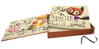
96271Paris Arte Adrien Maeght 1974. . Limited edition number 51 of 150 copies on Arches wove paper signed in red pencil by Miro from an edition of 200 with an additional 20 copies hors commerce; oblong folio 29 x 40 cm; title text and limitation on Arches wove paper 25 lithographs in total 20 colour 5 black and white including wrappers limitation page all bar three double-page; original paper wrappers with first lithograph printed on front spine and back; set of six lithographs in black by or after the same hand one with additions in red ball-point pen in beige paper folder entitled 'documents 1929' housed in publisher's orange cloth covered box with artist's and author's names on spine.<br /> A fine example of the limited edition signed by Miro in red pencil. <br /><br />Both the Spanish artist Joan Miro and the French poet Robert Desnos were prominent figures in the Surrealist movement in Paris where they met in 1925. Miro had long planned to illustrate a book by Desnos but the project was delayed by the outbreak of the Spanish Civil War and subsequently the Second World War in which Desnos was an active member of the French Resistance. He was arrested by the Gestapo in 1944 and sent to several concentration camps including Auschwitz and Buchenwald. Desnos survived the war only to die of typhoid a few weeks after the liberation of the camp where he was held. <br /><br />Nearly thirty years later Desnos' widow approached Miro with the idea of illustrating his works again. In the end they settled on Pénalités de l'enfer ou les nouvelles Hébrides The Penalties of Hell or The New Hebrides Desnos' first work in prose written in Morocco in 1922.<br /> Mourlot 959-90; Cramer 188. Paris, Arte Adrien Maeght, 1974. hardcover
46572Dressé sur les Relations les plus nouvelles de Mrs. de l'Académie Royale des Sciences par L. C. Desnos et J. B. Nolin Géographe. Se fait et se vends chez Desnos rue St. Jacque St. Severin Quartier de la Place Maubert. Paris 1760 avec privilége du Roy. Dedié au Roy par son trés humble trés obéissant et fidel sujet Desnos et monté par lui. Terrestrial globe 265 mm in diameter; engraved gores and two polar calottes with original hand-colouring over plaster base a few old sealed tears without loss; graduated equator tropics of Cancer and Capricorn ecliptic and Premiere Meridian fixe de l'isle de fer the prime meridian on the island of El Hierro which Louis XIII decreed in 1634; two cartouches - including the dedication to the King sometimes found removed during the French Revolution - decorative vignettes of exotic fauna indigenous peoples and maritime vessels numerous coloured tracks of historical and contemporary explorers including Ferdinand Magellan Jacob Le Maire and Willem Schouten Louis de l'Isle de la Croyere Nicolas de Frondat Aleksei Ilyich Chirikov Jean-Baptiste Charles Bouvet de Lozier and Admiral George Anson; papier-mâché meridian ring with printed declination and elevation engraved calendrical papier-mâché horizon ring with zodiac; edges painted red; supported on four papier-mâché quadrant arcs with the printed names of towns and their longitude and latitudes; turned wooden base and finial; total dimensions 600 x 390 mm; a few discreet signs of old restoration including at the North Pole; warm patina; a fine example of this rare terrestrial globe. A vividly illustrated French table globe from the mid-eighteenth century rich in geographical detail that includes the voyages and discoveries of French English Dutch and Russian explorers. Created during the reign of Louis XV by the partnership of Desnos and Nolin two great mapmakers of the period it is a tremendously evocative artefact from the Age of Enlightenment. The globe shows the discoveries made in the Pacific by the early European expeditions prior to those of Cook and the grands voyages of La Perouse Baudin Freycinet and Duperrey. It depicts the newly charted territory of Nouvelle Hollande as it was known from the most recent discoveries: the western coastline as well as the partial coastlines of Van Diemen's Land and New Zealand are based on the discoveries of the Dutch. Also marked are Dampier's Passage separating New Guinea from New Britain and Terre de S. Esprit Australia del Espíritu Santo the island in the New Hebrides originally mistaken by Quiros for the Australian continent. Louis-Charles Desnos 1725-1805 was one of the most prolific and influential map and globe makers of his age at a time when Paris was the major centre for map production in Europe. He married the widow of Nicolas Hardy the son of Jacques Hardy a globe maker active in the years 1738-1745. Desnos acquired Hardy's inventory and tools and expanded the company further through the acquisition of the inventories of the Jaillot family and of Nicolas de Fer. Desnos would be appointed Royal Globemaker to King Christian VII of Denmark and continued publishing throughout the late eighteenth century. Jean-Baptiste Nolin 1686-1762 continued the established business of his father the famous French cartographer engraver publisher and map dealer Jean-Baptiste Nolin 1657-1708. Collections: The only globe by Desnos recorded in Australian public collections is in the National Gallery of Victoria acquired from us in 2023. Another example of this globe is held in Libraries and Archives Canada. Provenance: Jean R. Perrette his bookplate pasted under the base of the globe. Jean R. Perrette's important collection of rare travel and exploration books was sold through Christie's New York in 2016 Sale 12259 Important Travel Exploration and Cartography April 5 2016. The globe is photographed in the catalogue in situ in Mr. Perrette's Library. Reference: van der Krogt Old globes in The Netherlands 1984 pp. 104-105 unknown