NEUGEBAUER, SalomonBiblio.com
28 résultats
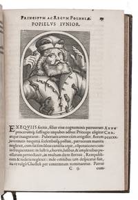
1620D7RBORMFQHCTFrankfurt am Main: Jacob de Zetter Hartman Palthenius 1620. 18th-century gold-tooled calf red sprinkled edges. Small 4to 20 x 14.5 cm. With an engraved title page and engraved portraits in the text. 3 works in 1 volume. With:2 SICCAMA Sybrand editor. Lex Frisionum sive antiquae Frisiorum leges a reliquis veterum Germanorum legibus separatim aeditiae & notis illustratae.Franeker Johannes Lamrinck 1617.3 VENICE. Risposta in difesa delle ragioni del. ser.mo Arciduca Ferdinando contra il manifesto publicato per la Republica di Venetia per occasione della presente guerra. Con l'oratione di Lodovico Eliano oratore di Lodovico XII. re di Francia havvta da lui contro la medesima Republica in augusta nel convento de' Prencipi di Germania alla presenza dell' imperatore Massimiliano I l'anno 1510. Italy Con Licenza de' superiori 1617. Three works from the early 17th century bound together. The first work is a popular illustrated history of Poland with portraits of monarchs theologians and emperors each with a short biography added by Salomon Neugebauer 1611-1654.The second work is the first edition edited by the jurist Sybren Siccama 1571-1622 of a legal work with the laws of Friesland. The first edition based on a now lost manuscript was printed in 1557.The third work is a rare anti-Venetian pamphlet in Italian written on the occasion of the Uskok War 1615-1618. This war was waged by Venice against a group of Balkan pirates Uskoks or Croatian-Habsburg soldiers which was stationed by the Habsburg ruler Archduke Ferdinand of Styria 1578-1637 later Ferdinand II along its frontiers as part of its military borders. The Venetian-Habsburg conflict eventually involved troops from all-over Europe with Venice the Dutch United Provinces and England on one side and the Austrian and Spanish Habsburgs on the other. The pamphlet includes an anti-Venetian Latin oration given in Rome by the French diplomat Louis Hélian in 1510.Tear in one leaf of the second work otherwise in very good condition.l Ad.1: BLC STC German 17th cent. N-136; Czapnik Rare Polonica 340; Hoskins 694; VD17 23:247745G; ad 2: cf. V.d. Aa XVII p. 645; NNBW VI col. 1239; ad 3: WorldCat 6 copies. Jacob de Zetter, Hartman Palthenius, unknown
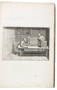
161214945London 1612. Royal folio 52 x 28.5 cm. John Norton printed partly by Jan Mommaert the elder in Brussels and partly by Richard Field in London Contemporary dark brown calf. Rebacked restored and with new endpapers. With an engraved architectural title page with Athena and Hermes representing wisdom and commerce a male and female satyr flanking the title four putti at the top with a sphere made from 12 stars arranged like the sides of a dodecahedron the authors device shown alone in the last illustration the 5 geometric solids and drafting and measuring equipment and 80 etched and engraved illustrations: 64 on otherwise blank pages mostly on integral leaves 2 across double-pages further mostly full-page and 16 on the text pages from small to half-page. The book has no letterpress page or leaf numbers but when a large engraving appears on a recto it usually has an engraved leaf number not a plate number that counts the books leaves beginning with the second leaf of quire a. Further with woodcut head- and tailpieces and dozens of woodcut decorated initials 6 series. engraved title 5 49 16 ll. including engravings. First edition of a famous and original treatise on perspective by the prominent mathematician Salomon de Caus 1576-1626 here in the very rare issue with the imprint of John Norton in London alone in 1612 with the name and date revised in the title-plate. The ESTC records 1611 London and 1612 London/Frankfurt issues of Caus's Perspective but not the present 1612 London issue.Caus was renowned as an inventor of mechanical devices both utilitarian and entertaining. His present work clearly explains and illustrates all aspects of perspective drawing including intricate projections optical illusions shadows anamorphic images and the mirroring of objects. With 2 contemporary perspective construction drawings in the foot margin of one page and some manuscript annotations. One plate has two small abrasions in the corner but the book is further in very good condition with only some small marginal tears and minor marginal water stains. Binding rebacked and restored so structurally sound. A very rare issue of the first edition of a classic work on perspective with 81 beautiful engravings.l Berlin Kat. 4706 not noting the Frankfurt imprint but listed in ESTC as the London/Frankfurt issue; ESTC S124665 1611 London issue & S122163 London/Frankfurt issue; STC 4868.7 1611 London issue & 4869 London/Frankfurt issue; Vagnetti EIIIb7: opera molto chiara splendid work the present 1612 London issue; VD17 1:080353E London/Frankfurt issue; not in BAL; Fowler; Millard but mentioning the London/Frankfurt issue under British 268. ABE CAT Art History unknown
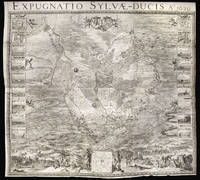
163114959Amsterdam: H.J. Van Wouw 1631. 1274 by 1405mm. 50.25 by 55.25 inches. Engraved wall map on six sheets joined eighteen inset views of the battle and siege works to left and right of the map. Large separately published six sheet map of the Siege of 's-Hertogenbosch during the Eighty Years War. <br/><br/>Hostilities between the Habsburg Empire and the Dutch Republic resumed in 1621 following the ending of the Twelve Years' Truce. The Habsburgs tried to punish the rebellious Dutch Republic by cutting it off from its hinterland by a land blockade. The blockade caused an economic crisis for the Republic and it reacted by trying to harm Spain in its colonies. In 1628 one of the many schemes undertaken met with spectacular success when Admiral Piet Hein of the Dutch West India Company captured the Spanish treasure fleet. With this windfall from the Stadtholder Frederick Henry decided to break the Habsburg blockade by launching a campaign against 's-Hertogenbosch. <br/><br/>'s-Hertogenbosch also known as moerasdraak swamp dragon was the main fortress in the Spanish blockading line and enormous sums of money had been poured into the improvement of its defences. As the ground surrounding the city was a marsh the city was generally deemed to be impregnable as the water-saturated soil seemed to make an application of current siege methods such as trench-digging and undermining impossible. <br/><br/>The Siege <br/><br/>Frederick Hendrik laid siege to the city in April 1629 with an army of 24000 infantry 4000 cavalry and 4000 peasants. He quickly set up a circumvallation and ordered the diverting of the two main streams feeding the swamps the Dommel and the Aa around the city by means of a forty kilometer long contravallation consisting of a double dike which completely enclosed the fortress; having thus created a polder he began to drain it by the use of horse drawn mills. After the soil had sufficiently dried out his siege trenches could begin to approach the city walls. So impressive were the siege works that noblemen travelled from throughout Europe to see them. <br/><br/>Attempts by the Habsburgs under the command of Hendrik van den Bergh Frederik's cousin to relieve the city proved unsuccessful as the circumvallation proved too strong and Frederik's forces dug themselves ever closer to the city along the southern road from the direction of Vught continuously bombarding the defences. During the siege 28517 cannonballs were fired. On 18 July the large Fortress Isabella fell followed the next day by Fort Anthony. Despite repeated sallies by the 2500 men of the garrison the attackers slowly worked their way to the southern city gate. There they undermined Bastion Vught; in the early hours of 11 September a massive explosion caused a large breach in the ramparts. On 14 September its military governor Anthonie Schetz surrendered the city. <br/><br/>The fall of 's-Hertogenbosch was an enormous blow to the prestige of the Spanish monarchy and the worst defeat in the North since the Spanish armada in 1588.3 As a result their position in the North would soon crumble and Frederick Henry encouraged by the success would start a series of other sieges assisted by his cousin Van den Bergh who changed sides after being accused of treason. <br/><br/>The Map <br/><br/>The map on six sheets provides a complete narrative of the siege; to the left and right are 18 inset views nine on each side for seige works dikes and principal forts. To the foreground two figures of Mars and a river god hold up a plan of the city. A group of figures to the lower right depict from right to left Frederick Hendrik surveying the battle field the artist Adriaan van de Venne who turns his head to the viewer and was responsible of the figurative work on the map and the military engineer and author of the map Theodoor Niels who is shown seated consulting a map. Beyond the immediate foreground several battle scenes are shown depicted various stages of the siege. To the centre of the map 's-Hertogenbosch is shown surrounded by the extensive siege works the circumvallation line is clearly marked - a chain of small and larger fortifications connected with a continuous parapet - designed to withstand a relief attempt from the outside and the smaller contravallation line and dike which Hendrick used to drain the swamp. Prominence is given to the Dutch camp at Vught south of the city. The intricate trench works so vital for victory are meticulously delineated and the breaching of the city wall is clearly marked. All prominent landmarks and aspects of the siege are marked by a number that correlated with an explanatory text which accompanied the map. <br/><br/>The author of the map was Theodoor Niels a military engineer in the Dutch army. Niels together with Jan Adriaansz Leeghwater whose water mills and dike work had managed to dry the land surrounding the city were the leading military engineers at the siege. Niels was principally responsible for the construction of the extensive trench network which meant spending a great deal of time on the frontline; a fact that almost cost him his life when on the night of the 22nd June 1629 the defenders exploded a mine under one of his trenches burying him alive. Assumed death he was only rescued when his head and hands were spotted poking out from beneath the rubble. He was fated as a hero and awarded a gold medal for his bravery. Unfortunately his luck would eventually run out when in 1633 he was killed during the battle of Rijnbeek. <br/><br/>On December 7th 1629 the States General recognized Niels vital role by not only awarding him a gold medal and a substantial cash sum but also granting him a privilege of four years in order to produce a great map of the battle. <br/><br/>To enable him to complete the task Niels employed some of the leading artists and engravers working in Amsterdam at the time. These included: the figure and genre painter Adriaan van de Venne who was responsible for the scenes in the foreground and whose sketches would be engraved by Salomon Savery; the plan of the siege would be completed by Balthasar Florenz van Berckenrode whose monumental wall map of Amsterdam published in 1625 had met with such great praise and whose map of Breda of 1637 bears striking similarity to the present work. <br/><br/>Rarity <br/><br/>We are only aware of four institutional examples all of which are located in the Netherlands: Leiden University Library; Amsterdam Rjksprentenkabinet; Dordrecht Museum Simon van Gijn; and Rotterdam Atlas van Stolk. H.J. Van Wouw, unknown