Michel Etienne Turgot ; Louis BretezBiblio.com
178 résultats
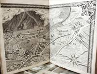
1739B3268Paris: Michel Turgot c. 1739. A fine copy plates are generally very clean and crisp and the atlas is in superb period binding. Edition: First Edition. Binding: recent red full morocco with the coats of arms of Paris. <br><br> Notes: This is the most beautiful and celebrated plan of the city of Paris. Turgot’s maps were designed and engraved with scroll borders to the extreme edges so that the entire twenty plates could be assembled to form one complete map of Paris 8 ½ x 10 ½ feet. Each arrondissement is shown from a birds-eye view; not only are the streets named and portrayed in detail but all of the houses hotels churches monuments private gardens and city parks are delineated in panoramic perspective such that the architectural ornamentation of the buildings can be identified. Size: Tall folio 560 x 455 mm Illustration: Complete with 20 double-page engraved panoramic maps and double-page index plan. References: Berlin Katalog 2506; Boutier 219 Pages: P. 21 double-page plates. Category: Book Atlas & Cartography; Book Europe France; Book Plate Books General; Michel Turgot unknown
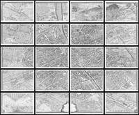
54315Paris: 1734-39. FIRST EDITION. 20 original engraved double page sheets each c. 52 x 80 cm here presented as 20 framed panels each measuring c. 56 x 85 cm giving a total wall space of 280 x 340 cm. A fascinating and colossal view of Paris and amongst the greatest city views of all time. Turgot's map of Paris is possibly the most ambitious urban mapping ever undertaken. This map shows the whole of 18th century Paris and offers an expansive perspective on the city before Baron Georges Eugène Haussmann's 19th-century redesign. Turgot who held the mayor-like office of Prevôt des Marchands de Paris commissioned Louis Bretez and Claude Lucas to produce this map. Oriented to the east on an axonometric projection this map is best understood as an aerial view where in every building window tree shadow and park are shown from an equidistant aerial perspective. In order to produce the thousands of sketches and surveys required to complete this map Bretez was issued a permit to enter every building in Paris. It took the team nearly five years of exhaustive sketching and surveying to assemble this masterpiece. A Monumental Achievement With unprecedented access to the properties of Paris and an official mandate Bretez achieved outstanding detail and accuracy. The buildings of Paris are presented as one would have seen them at the time. The Louvre the Tuileries Garden Notre Dame Cathedral and the Champs Élysées can all be easily recognised. The Bastille the flashpoint of the French Revolution which would start 58 years later is depicted as well. Michel-Etienne Turgot 1690-1751 Louis XV's Prévot des Marchands commissioned this plan in 1734 from Louis Bretez a sculptor painter and perspective specialist who used the conventional bird's-eye representation isometric projection. The stunning result shows maps with great and decorative detail being an important record of the architecture and gardens of Baroque Paris the world capital at the time. This was the last major example of this type of plan. Turgot was chief of the municipality of Paris as provost of merchants the equivalent of today's mayor. He was the father of the famous economist and statesman Anne-Robert-Jacques Turgot whom history remembers chiefly as an early advocate for economic liberalism. Turgot was motivated to commission a map of Paris by his will to champion the reputation of the city for Parisian provincial or foreign elites. As such he asked Louis Bretez a French architect cartographer and professor of perspective who belonged to the Royal Academy of Painting and Sculpture to draw up the plan of Paris and its suburbs. Over his two years of work 1734-1736 Bretez was granted access to all the houses and gardens he needed to visit in order to take the relevant measurements. Paris: 1734-39 unknown
173948765Paris 1739. First Edition. Hardcover. Very Good. Turgot's Monumental Plan of Paris With Excellent Provenance. Elephant Folio 56.5 x 45.5 cm. A magnificent and complete example of the celebrated Plan de Paris commonly known as the Turgot Map housed in a handsome contemporary red Morocco binding with gilt borders spine compartments and bands. The arms of the city of Paris are gilt-stamped to both boards. Neatly rebacked; light rubbing and minor scuffing to the leather. Internally excellent: the sheets are remarkably bright clean and free from repair or loss with only some very faint marginal staining and a couple of spots throughout and the large folding spread with some light discolouration to a couple of the folded corners. Includes the full set of 20 engraved sheets with sheets 18 and 19 joined at the center and folded as issued. The title appears within the ornate cartouche on the key map. A small bookseller's ticket from the famed French antiquarian Pierre Berès is affixed to the upper fore-edge corner of the front paste-down. This is a superbly preserved example of one of the most extraordinary cartographic accomplishments of the 18th century. Commissioned in 1734 under the direction of Michel Étienne Turgot then Prévôt des Marchands Provost of the Merchants of Paris and a senior official in Louis XV's administration the map was designed to glorify the French capital as the political cultural and architectural heart of the kingdom. Louis Bretez a skilled draftsman and member of the Royal Academy of Painting and Sculpture was granted exclusive access to the interiors courtyards and rooftops of the city. Working in a dramatic bird's-eye axonometric perspective Bretez rendered the streets gardens landmarks and even individual buildings in intricate three-dimensional detail. The engravings were executed by Claude Lucas and the full project was completed in 1739 resulting in a masterwork of urban representation. Unlike conventional maps the Turgot Plan was conceived not merely as a geographic tool but as a grand artistic vision: part city portrait part political statement. It remains an unrivaled view of Paris under the Ancien Régime just decades before the French Revolution would transform the urban and social landscape. Widely distributed across France and to the royal courts of Europe the Turgot Map was intended to impress dignitaries scholars and ambassadors alike with the power and refinement of the French capital. Today complete copies in such fine condition are exceedingly scarce. This example with its contemporary binding and provenance would be a great addition for any serious collection of cartography Parisiana or French Enlightenment-era printing. Provenance: A Montreal family purchased from Christie's Canada with Montreal Book Auctions 1970. The Property of the Hon. Madame Georges P. Vanier. With a letter from the auction house and a letter from Parisian dealer Pierre Beres addressed to the buyer confirming this as the copy he sold to General Charles de Gaulle to present to the Governor General Vanier. hardcover