Ptolemy; Girolamo RuscelliBiblio.com
335 résultats
1574M7272Venice: Ruscelli c. 1574. Very Good;. Notes: Italian text on verso.<br>Map of the ancient region of Asiatic Sarmatia.<br>Girolamo Ruscelli 1518–1566 was an Italian mathematician and cartographer active in Venice during the early 16th century. He was also an alchemist writing pseudonymously as Alessio Piemontese.<br>Claudius Ptolemy better known mononymously as Ptolemy was a Greco-Roman mathematician astronomer astrologer geographer and music theorist who wrote about a dozen scientific treatises three of which were important to later Byzantine Islamic and Western European science. Size : 188x262 mm 7.40x10.31 Inches Coloring: Hand Colored Category: Maps Russia; Ruscelli unknown
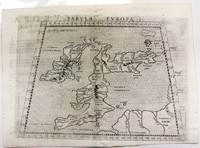
1574M11040Venice c.1574. Very Good. Notes: Map of the British Isles United Kingdom based on Ptolemy's map.<br>Girolamo Ruscelli 1518–1566 was an Italian mathematician and cartographer active in Venice during the early 16th century. Ruscelli is best known for his important revision of Ptolemy's Geographia published posthumously in 1574. Size : 190x262 mm 7.48x10.31 Inches Coloring: Black & White Category: Maps Europe United Kingdom; unknown
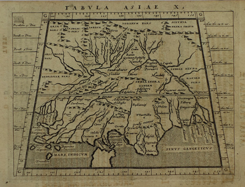
1598M8431Venice: G. Fratelli; G.A. Magini c. 1598. Very Good. Notes: Ptolemaic Map of Tabula Asiae X Plate 10 from "Geografia cioe Descrittione Universale della Terra" published by Magini c.1598. Text in Italian.<br><br><br><br> Size : 140x173 mm 5.50x6.80 Inches Coloring: Black & White Category: Maps Asia Central Afghanistan Pakistan; Maps Asia Central India & Sri Lanka / Ceylon; G. Fratelli; G.A. Magini unknown
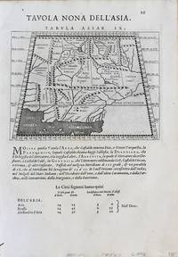
1598M8430Venice.: G. Fratelli; G.A. Magini c. 1598. Very Good. Notes: Ptolemaic Map of Tabula Asiae IX Plate 9 from "Geografia cioe Descrittione Universale della Terra" published by Magini c.1598. Text in Italian. Size : 140x173 mm 5.50x6.80 Inches Coloring: Black & White Category: Maps Asia Central Afghanistan Pakistan; Maps Asia Central Turkmenistan Uzbekistan Tajikistan Kyrgyzstan Kazakhstan; Maps Asia Central India & Sri Lanka / Ceylon; G. Fratelli; G.A. Magini unknown
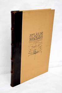
19833638099Valencia.: Vicent García. 1983. Hardcover. Falta el facsimil con los mapas . Good. 46 cm. 1 v. il. col. map. col. Encuadernación en tapa dura de editorial holandesa. Libro de estudios del facsimil. Introducción por Víctor Navarro Brotóns ; traducción y notas por Angel Aguirre Alvarez Víctor Navarro Brotóns y Enrique Rodríguez Galdeano. Tít. de la cub. : Atlas de Claudio Ptolomeo . Falta el facsimil con los mapas . ISBN: 8485094352 v.1 Geografía del mundo antiguo. Geografía regional en general. Geografía universal 913.1"01" Mapas. Atlas geográficos. Globos terráqueos 912100:528.9:091.07 Vicent García. hardcover
1786RW1618Nancy:: Chez C. S. Lamort 1786. 1786. 4to. 2 vi 192 2 pp. 2 large folding zodiac maps. Title vignette full mottled calf leather gilt-stamped spine label raised bands; joints worn corners showing. Very good. Side-by-side translation of Ptolemy's Greek into French describing the position of the stars during Ptolemy's lifetime. / "Montignot has given us the original Greek and a French translation of the seventh book of Ptolemy's great work under the title of `Etat des etoiles fixes au second siecle' in quarto. He has given the designation of the same stars by Flamstead Flamsteed and Beyer and their position in the year 1786." – Thomas Jefferson to Joseph Willard. Chez C. S. Lamort, 1786. hardcover books
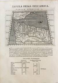
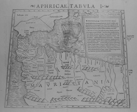
1598M8434Venice: G. Fratelli; G.A. Magini c. 1598. Very Good. Notes: Ptolemaic Map of the North west part of Africa Morocco Tabula Aphricae I Plate 1 from "Geografia cioe Descrittione Universale della Terra" published by Magini c.1598. Text in Italian.<br><br><br> Size : 140x173 mm 5.50x6.80 Inches Coloring: Black & White Category: Maps Africa North; Maps Africa West; G. Fratelli; G.A. Magini unknown
1617LBW-1935[Arnhem, Joannes Jansson, 1617]. 130 x 169 mm.
1617LBW-1964[Arnhem, Joannes Jansson, 1617]. 129 x 170 mm.
159616119Venice:: Giovanni Magini 1596-1598. Map 5 x 6.75 inches on 11.5 x 8 inch leaf. Single leaf from Giovanni Maginis Geographicae Ptolemaei 1597-1598. Revised edition of Ptolemys Geography. Copperplate engraved map of Asia. Latin text to map. Italian text to recto and verso of leaf. Large initial L below map. Engraved by Girolamo Porro. A fine impression. Scarce. Most suitable for framing. Map is 5 x 6.75 inches on leaf at 11.5 x 8 inches. Giovanni Antonio Magini 1555-1617 Italian astronomer astrologer cartographer and mathematician. Girolamo Porro 1520-1604 famous Italian engraver on wood and on copper. Maginis Geographia was first published in 1596 Latin and in 1597 & 1598 in Italian. The maps detailed and extremely attractive were engraved by the famous Porro. Authorities generally believe that they are the finest of the small size Ptolemies following those by Gastaldi done earlier. [Giovanni Magini,] unknown
1972010314PARIS CLUB DU LIVRE PHILIPPE LEBAUD 1972 Un fort volume grand in-folio de 206 pges , dans sa très belle reliure éditeur plein cuir havane , dos plat , motifs de frises grecs inscrustés sur les plats et médaillon en cuir sur le premier plat , tête doré et bien complet de bsa chemise et de sa boite bordurée , ouvrage comportant 20 lithographies originales en couleurs de Jean PICART LE DOUX , tirage à 300 ex. numérotés , un des 225 sur Rives signé par l' artiste , très bon exemplaire . PORT POUR LA FRANCE 20 ? ET POUR L' U.E. 28 ? Très bon Couverture rigide
1552LBW01b4b[Bâle, 1552]. 268 x 333 mm.
41734Paris Catala Frères, imprimeurs-Editeurs 1925 in 4 (33x25,5) 1 chemise à lacets de l'éditeur, dos de percaline titré en long, plat supérieur titré, renfermant un fascicule de texte de 6 pages [1], suivi de 75 planches hors-texte volantes. Collationné complet. Bel exemplaire ( Photographies sur demande / We can send pictures of this book on simple request )
1819RO80255816Imprimerie de A. Bobée. 1819. In-4. Relié. Etat d'usage, Coins frottés, Dos fané, Quelques rousseurs. xliv + 88 + 54 + 20 + 183 + 18 + 37 pages. Quelques tables dépliantes hors texte. Titre doré au dos, pièce de titre verte. Trois photos disponibles.. . . . Classification Dewey : 904-Recueils de récits d'événements
1896000021169Glasgow: Hay Nisbet and Co. 1896. later edition. hardcover. Poor. Octavoapprox. 5 3/8" by 7 7/8" flexible brown leather covers xxvii 5 246 1 pages. Title page browned but the rest of the text is clean and unmarked. Repairs with linen tape at hinges as well as internally. Titling on paper spine label very faded. Mottling on covers damaged area at foot of spine and bottom of rear cover; no text is affected by the damage. 092717B <br/><br/> Hay Nisbet and Co. hardcover
1991DADAX0486268969Dover Publications 1991-11-19. paperback. New. 9.50x1.00x12.25. Buy with confidence. Excellent Customer Service & Return policy. Dover Publications paperback
1998SKU0228145Princeton University Press 1998-10-19. Paperback. Good. Textbook May Have Highlights Notes and/or Underlining BOOK ONLY-NO ACCESS CODE NO CD Ships with Tracking Princeton University Press paperback
1617LBW-1926[Arnhem, Joannes Jansson, 1617]. 130 x 168 mm.
1617LBW-1923[Arnhem, Joannes Jansson, 1617]. 128 x 170 mm.
1617LBW-1938[Arnhem, Joannes Jansson, 1617]. 128 x 168 mm.
1617LBW-1918[Arnhem, Joannes Jansson, 1617]. 130 x 168 mm.
1617LBW-1934[Arnhem, Joannes Jansson, 1617]. 130 x 169 mm.
1617LBW-1933[Arnhem, Joannes Jansson, 1617]. 129 x 170 mm.
1617LBW-1932[Arnhem, Joannes Jansson, 1617]. 129 x 167 mm.
1617LBW-1931[Arnhem, Joannes Jansson, 1617]. 127 x 163 mm.